This book studies places and spaces in Western India both as geographical locations and as imagined constructs. It uncovers the rich history of the region from the perspective of places of pilgrimage, commerce, community, expression and indigeneity.
The volume examines how spaces are intrinsically connected to the lived experiences of people. It explores how spaces in Western India have been constructed over time and how these are reflected in both historical and contemporary settings – in the art, architecture, political movements and in identity formation. The rich examples explored in this volume include sites of Bhakti and Sufi literature, Maharashtrian-Sikh identity, Mahanubhav pilgrimage, monetary practices of the Peshwas and the internet as an emancipatory space for the Dalit youth in Maharashtra. The chapters in this book establish and affirm the forever evolving cultural topography of Western India.
Taking a multidimensional approach, this book widens the scope of academic discussions on the theme of space and place. It will be useful for scholars and researchers of history, cultural studies, geography, the humanities, city studies and sociology.
Urban, rural and indigenous spaces in Maharashtrian politics and environment
Chapter 1
The aftermath of placeless space: mapped, delimited, bifurcated, merged
A phenomenon of Dewas S. and Dewas J.
Irina Glushkova
Introduction
What was once the twin-states of Dewas is now a district, which takes its name from its headquarters at the city of Dewas. This city is now the home of 290,000 citizens and houses one of the largest bank note presses in Asia; it is also the known as the soya capital of India. It is easily found on the administrative map of modern Madhya Pradesh about 143 km southwest from Bhopal, the state capital, and 35 km northeast from Indore, its commercial hub. The popular etymology links the town’s name to Chamunda, a local goddess, or devīvāsinī, whose abode is located in a rocky shrine on the top of a conical hill 300 feet high, a single salient geographical feature of the local landscape, now also occupied by a variety of deities. More than a century ago, Malcolm Darling, a colonial civil servant, in a letter to his friend Edward Morgan Forster, a British writer, described Dewas as the ‘oddest corner of the world outside Alice in Wonderland’. In 1908, one year after his arrival here, Darling mentioned in another letter, ‘How I loathed the place then! Now I could hardly wish for anything better’.1 To this about thirteen years later in a letter comparing Dewas Senior with another tiny principality, Forster reinforced his friend’s perception, ‘How I wish that Dewas wasn’t so meagre! Though I have no doubt as to which state I would choose to live in’.2 It is because of Forster who managed to have finally shaped his otherwise abandoned novel – The Passage to India3 – after his return from Dewas to England that this name still rings a bell outside India. Three decades later Forster’s letters from India to his mother and kin were brought together under the title of The Hill of Devi, preceded by a note he supplemented at the time of their publication his faithful dues to Dewas’ ‘fineness’ and ‘strangeness’, ‘It was the great opportunity of my life’.4 He sums up in one of his letters his impression of the place: ‘Here, indeed, was a very dull India, except for Devi, the sacred acropolis with the rakish cap, half a mile away … She concludes the curiosities of Dewas. Nothing detained the tourist there, and the surrounding domain was equally unspectacular. No antiquities, no picturesque scenery, no large rivers or mountains or forests, no large wild animals, “usual birds and fishes,” according to the gazetteer, no factories, no railway station. Only agriculture … Amidst these surroundings, I was to pass six months of 1921 in the capacity of a Private Secretary [to Maharaja Tukojirao Pawar III]’. (Figures 1.1 and 1.2)5
Figure 1.1 Location of contemporary Dewas.
Since then, the colonial government built the Agra–Bombay road, now known as the National Highway 3, running through Dewas; in 1952, the railway came here. It has also become an object of my focused interest, and for the last few years, I have kept tracking its past glory and collecting my own set of impressions of the span and structure of the eighteenth-century Maratha Confederacy and of the princely state(s) which had been once jointly owned by the renowned Maratha generals Puar/Ponwars/Pawar brothers and then divided by their descendants into Dewas Senior and Dewas Junior, both worth fifteen-gun salute as per the British hierarchical table of military honours.
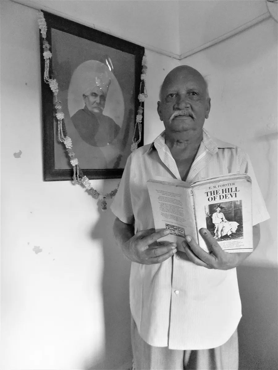
Figure 1.2 Mr. Vijay Pandit, a resident of present-day Dhar, next to a photo of his grandfather, a dewan of Dewas Senior during the times of Tukojirao III. In Pandit’s hands is a copy of The Hill of Devi featuring an image of Forster.
*
‘Looking at any wall map or atlas, we see a world composed of states. The earth’s surface is divided into distinct state territories. Each demarcated by a linear boundary, an edge dividing one sovereignty from the next. The division is accentuated when each territory is blocked out in a separate colour from neighboring states, implying that its interior is a homogeneous space, traversed evenly by state sovereignty. Our world is a jigsaw of territorial states, and we take this picture for granted’.6 This quotation from Michael Biggs’ insightful paper on cartography and state formation was on my mind when I tried to pin down on the few old maps within my reach a location of disjoined parts of the former Maratha principality known as the twin-states of Dewas (17287–1948), in the historical region of Malwa.
The cartography of the Maratha Confederacy during its prime in the eighteenth century is usually shown as a coloured continuum slightly varying in size and configuration, which creates an impression of the Marathas’ sway over a significant part of the Indian subcontinent. This ocular experience would have been unknown to actors of that turbulent period who had neither validated the very concept of the Maratha Confederacy8 nor embraced fragments of the Maratha realm scattered here and there as an enclosed space or perceived them in terms of ‘territory’. Besides their nucleus in Desh (i.e. deś, ‘[our own] country’, a part of the west-central Deccan Plateau bounded by the Sahyadri range and its spurs, which eventually became a topographic designation of the geographical and historical region), the hold over vast areas beyond Maharashtra seems to have been never achieved simultaneously and evenly. The continuously yellow-coloured fragments of maps spreading and widening to the north off the seat of power in Pune also include the area of Malwa, and only roughly indicate their balancing claims to fiscal control neither certain nor secure at different points in time. These claims or rights ‘always under sanction or pretended sanction of the Emperor’ in Delhi were ‘nothing but a prelude to the establishment of complete Maratha sovereignty’, or svarājya, ‘not to be defined as an abstract, territorially circumscribed, dominion complete in itself’.9 This initial understanding of svarājya in the sense of non-moṅglaī is set by Andre Wink against pararājya, or moṅglaī, while both are ‘intermingled … to such an extent … that the concept of territory becomes fallacious’, and makes sense only as a reference to maharāṣṭra rājya10 located in Desh. These claims to the shared space were enforced by the distribution of sarañjams, such that the bonds with clans of leading commanders and their promotion to the rank of sūbhedārs in different parts of Malwa would pave the way to the ‘slow conquest’ of this buffer zone between Maharashtra and Hindustan11 by the Southerners, as Marathas rooting outside Maharashtra had been recognized to the north of their nucleus. Therefore, the disparity of their ‘conquered lands’, including the specific case of Dewas with regard to either Maratha sovereignty or membership in the Maratha Confederacy, resists representation in terms of colours and border lines shown onto a cartographic space. These hallmarks were introduced by colonial historians for visual painting in red and pink the British expansion but later were put to use again through map renaming by students of Maratha history.12
Apart from the intermingling of svarājya and moṅglaī, some pargannās (an administrative unit of several villages) in various parts of Malwa as well as in Maharashtra were owned jointly by leading sardārs. This, while adding to the complexity of the ‘territory’ issue, also diminished a ‘place’ (ṭhikāṇ/ṭhāṇ13) value in the flexural space of the Maratha Confederacy. This ambiguous, varied and dynamic kind of space14 by no means resembled a homogeneous cartographic image of the Maratha Confederacy, which nowadays stands almost as its ‘geobody’ and ‘logo-map’ through its mass reproduction in school textbooks, historical literature and the internet.
The shift from the non-territorial concepts of moṅglāī and svarājya (in its initial meaning) had been manifested by the growth of the extraterritorial Maratha Empire, at a later date divided into quasi-states, known as principalities, princely states, rājya, riyasāt, saṃsthān, etc. As this process was regulated by the Europocentric mentality of the East India Company’s administration, they were formed in accordance with the idea of a ‘territory state’ which had developed since the Peace Treaty of Westphalia (1648) and subsequent transformation of the European landscape. It seems problematic to trace Marathi analogues of ‘territory’ (derivative of Latin ‘territorium’, meaning ‘the area of land surrounding and within the boundaries of a Roman city, municipium etc.’) which is associated with ‘place’ and ‘power’ but is different from ‘land’ and ‘terrain’. Marathi speakers substitute this notion of political geography for various lexemes related to spatial unity such as deś, pradeś, bhūbhāg, prānt, mūlūkh, rāṣṭra, etc., including Sanskrit kṣetra, by thus ignoring the historical context of each alternative. This substitution creates a sort of a ‘territorial trap’15 by juxtaposition of Indian glosses with outside concepts, especially with those which keep on being debated till now. Stuart Elden, tracing within Western political thought the emergence of the notion of ‘territory’ suggests that ‘[t]erritory clearly implies a range of political issues: it is controlled, fought over, distributed, divided, gifted, bought and sold. It is economically important, strategically crucial and legally significant’.16 By the same token, the interplay of two words – ‘place’ and ‘space’ which form the title of this volume – are juxtaposed with and opposed to each other at the same time meaning different things to different scholars. Both are difficult to get planted into the Marathi language soil, and by trying it we may do injustice to indigenous concepts, which might indicate different approaches and modes to the creation of spatial and geographical me...
Table of contents
Cover
Half Title
Title Page
Copyright Page
Dedication Page
Table of Contents
List of figures
List of contributors
Foreword
Acknowledgements
Introduction: location, expositions and synthesis in the region
Part I Urban, rural and indigenous spaces in Maharashtrian politics and environment
Part II Constructing space and place: material culture and public spaces
Part III Religious spaces and places in Western India
Appendices
Index
Frequently asked questions
Yes, you can cancel anytime from the Subscription tab in your account settings on the Perlego website. Your subscription will stay active until the end of your current billing period. Learn how to cancel your subscription
No, books cannot be downloaded as external files, such as PDFs, for use outside of Perlego. However, you can download books within the Perlego app for offline reading on mobile or tablet. Learn how to download books offline
Perlego offers two plans: Essential and Complete
Essential is ideal for learners and professionals who enjoy exploring a wide range of subjects. Access the Essential Library with 800,000+ trusted titles and best-sellers across business, personal growth, and the humanities. Includes unlimited reading time and Standard Read Aloud voice.
Complete: Perfect for advanced learners and researchers needing full, unrestricted access. Unlock 1.4M+ books across hundreds of subjects, including academic and specialized titles. The Complete Plan also includes advanced features like Premium Read Aloud and Research Assistant.
Both plans are available with monthly, semester, or annual billing cycles.
We are an online textbook subscription service, where you can get access to an entire online library for less than the price of a single book per month. With over 1 million books across 990+ topics, we’ve got you covered! Learn about our mission
Look out for the read-aloud symbol on your next book to see if you can listen to it. The read-aloud tool reads text aloud for you, highlighting the text as it is being read. You can pause it, speed it up and slow it down. Learn more about Read Aloud
Yes! You can use the Perlego app on both iOS and Android devices to read anytime, anywhere — even offline. Perfect for commutes or when you’re on the go. Please note we cannot support devices running on iOS 13 and Android 7 or earlier. Learn more about using the app
Yes, you can access Spaces and Places in Western India by Bina Sengar,Laurie Hovell McMillin in PDF and/or ePUB format, as well as other popular books in History & Indian & South Asian History. We have over one million books available in our catalogue for you to explore.