![]()
TWENTY-SEVEN
THE TRANS-CANADA HIGHWAY:
CANADA’S SECOND “NATIONAL DREAM”
When the first CPR trains puffed in to the Vancouver station in 1886, the railway was considered the new country’s “national dream”; it linked the country not only physically but also politically. Then, eight decades later, another “national dream” was realized: the opening of the Trans-Canada Highway.
While the construction of the CPR took only a decade and a half, nearly six decades were needed to complete the highway link. At more than seven thousand kilometres, it is the world’s longest named coast-to-coast highway. Mark Richardson, writing in Maclean’s magazine, once described it as “a necklace across the country, linking Canadian provinces and their people to each other in a tangible, physical and highly visible way.”
The kick-start for a cross-country highway predates even the First World War, when few Canadians had even seen a car. In May 1912 the car-loving members of the Victoria Car Club and the Canadian Highway Association gathered near the Pacific shore in Tofino, British Columbia, and pounded into the ground a sign that read “The Canada Highway.” And so the notion of the Trans-Canada Highway was conceived. To encourage their dream, they offered a medal to the first brave soul to drive across the country using roads entirely within Canada. The problem was that there were none.
Nevertheless, a British journalist named Thomas Wilby, based in New York, believed that such an adventure would make a great story; he convinced the Reo Car Company to provide him with a vehicle and mechanic and off he went. (The Reo Car Company was named for Ransom E. Olds, who later lent his name to the Oldsmobile.)
On August 27, 1912, along with his mechanic and driver, Jack Haney of St. Catharines, Wilby dipped his tires into the Atlantic Ocean in Halifax. But the going proved to be rougher than he had expected. While he managed to make his way through Quebec and southern Ontario using existing roads, which were variously muddy and sandy, he discovered that in North Bay there was no longer any road at all. Against his wishes, he had little choice but to hoist his car onto a train and make his way to Sault Ste. Marie. Unfortunately, he missed the boat that would carry him to Port Arthur, where, when he finally arrived, he once more discovered that there was no road. So it was train again to the prairies.
Despite the gumbo roads, he managed to reach the Rockies. But here again he needed to resort to a combination of rail and rough mountain trails to bring him finally to Vancouver and then by boat to Victoria, where, on October 14, he could at last dip his tires into the Pacific. The medal was not to be his, however, for he had failed to remain on an all-road route.
Through the 1920s, Dr. Perry Doolittle continued to lobby on behalf of the Canadian Automobile Association for the road across Canada. And, indeed, in 1925 he drove across the country himself. Although he had better luck than Wilby, there was still no all-Canada road. Not until the make-work road building of the Depression years did the notion of the Trans-Canada Highway begin to resonate with the federal government.
By 1943 a crude road network did finally exist, and in 1946, Brigadier R.A. Macfarlane and Kenneth MacGillivray completed the first drive across the nation using all-Canadian roads, a feat they accomplished in just nine days. The medal was theirs.
The momentum for a national road had begun to accelerate. In 1949 the federal government passed the Act to Encourage and Assist the Construction of a Trans-Canada Highway — in short, the long-awaited Trans-Canada Highway Act. By upgrading existing provincial roads and adding new links, the TCH was intended to follow the shortest route between the oceans. Provincial lobbying, however, ultimately created a number of alternate routes.
There were to be strict construction standards. The road bed was to be between 6.7 and 7.3 metres wide, with a slope of no more than 6 percent and visibility no less than 183 metres. Provinces would build the road with the federal government shouldering 50 percent of the cost — 100 percent where the route passed through a national park. It would be completed by 1956. Or so they thought.
The inevitable federal-provincial disputes over jurisdiction and cost sharing delayed the opening until September 1962, when political dignitaries led by Prime Minister John Diefenbaker snipped the ribbon in the Rogers Pass in the Rocky Mountains.
The following year, Ed McCourt and his wife became the first to drive the new road (although they were to discover that much remained unpaved).
THE ROAD TODAY
The cross-Canada route today no longer presents the challenge that confronted Wilby, Doolittle, and MacGillivray. While there are those who hike it or bike it for charity, few car drivers undertake the journey as a must-do, which is somewhat unfortunate as the national highway provides a cross-section of our nation’s history and geography as well as some of the country’s most scenic and even oddest sights.
It almost seems like human nature to move from east to west. That, after all, is how the sun moves and how that first national dream unfolded.
While there is little opportunity to dip car tires in the Atlantic at St. John’s, Newfoundland (which was not yet a part of Canada when Wilby started out), the boat launch at nearby Petty Harbour does allow that. But it will be from the Mile 0 marker in St. John’s itself, with its iconic brightly painted cliffside houses and its historic Signal Hill, that the venture can truly begin.
Animal overpasses along the forested portions of the Trans-Canada Highway help reduce fatal collisions between motorists and wildlife.
While a long, dreary drive of seven hundred kilometres leads the Trans-Canada Highway (TCH) across the island province, many side trips lead along scenic peninsulas with their outports, coves, and intriguing place names, like Heart’s Content, Heart’s Delight, Tickle Cove, and the curiously named Dildo. (Dildo is a name that dates to 1711 and was a term often used for a nautical pin. Despite its modern sexual connotation, the town steadfastly refuses to change its name and, indeed, hosts an annual Dildo Days.)
Marine Atlantic’s ferries connect Port aux Basques, Newfoundland, to North Sydney on Cape Breton Island. It was at Louisbourg, a short distance east of North Sydney and site of today’s wonderfully reconstructed and massive Fortress of Louisbourg, and not St. John’s that trippers Macfarlane and MacGillivray dipped their wheels in the Atlantic for Canada’s first all-Canadian cross-country road trip in 1946. (Newfoundland would join Confederation three years later.)
The Canso Causeway, built in 1955 to lure Nova Scotia to participate in the TCH project, connects Cape Breton Island with the mainland. From there, the TCH continues through the rolling Nova Scotia landscape to Moncton, New Brunswick. Rejecting that province’s plea to route the highway through Saint John, the federal government instead took the highway through the capital, Fredericton, and then along the scenic shores of the Saint John River to Edmundston in the heart of Acadian country. Today the TCH has been widened and straightened, and now, as Highway 7, it bypasses the frequent riverside villages of its original alignment, including Hartland, with the world’s longest covered bridge.
Once the TCH reaches the St. Lawrence River, it becomes Quebec Autoroute 20 and remains inland, avoiding the busier river road that was its original route. Up to Quebec City, the route displays scenic views over the wide river, passing several historic villages with their tall, silvery church steeples. After bypassing the ancient provincial capital that lies on the north side of the river, the TCH then moves farther inland along the flat and less scenic St. Lawrence lowlands.
Happily, today’s TCH ignores its early route through the congested centre of Montreal and keeps well south of the city before crossing the St. Lawrence River farther west. Upon entering Ontario, it then swings northwest to follow the Ottawa River toward Ottawa. Here, it becomes Highway 417, again farther inland from its former alignment, the more historic and scenic Highway 17.
In Ottawa, the TCH becomes a major urban route and is frequently congested until it escapes the gridlock and enters the countryside of the Ottawa Valley as Highway 17. Passing outside the historic mill town of Renfrew, the TCH makes its way along the Ottawa River Valley and enters the rugged landscape of the Canadian Shield, where it encounters communities like Pembroke, Chalk River, and Deux-Rivières, with occasional views over the river to Quebec’s Laurentian Mountains. At Mattawa, it veers west to North Bay and eventually to Sudbury.
Ontario ended up with more than one Trans-Canada Highway. An alternative route from Ottawa follows provincial Highways 7 and 12 west to Orillia, where it becomes Highway 69/400, and, after passing through the pink granite barrens of the Canadian Shield, eventually rejoins the main TCH at Sudbury.
This two-lane alternative is more varied than the main TCH 17, winding through a string of historic towns, such as Perth, known as Ontario’s prettiest town, and Madoc, the jumping-off point for Ontario’s first gold rush in 1866. (In that year, eager prospectors hurried to the supposedly fabulous gold find at Eldorado only to find many claims were fraudulent. Eldorado today is a virtual ghost town.) Marmora, the next heritage community, was once Canada’s iron ore capital, remembered today with the historic Miner’s Loop driving trail. Leading to Peterborough, TCH 7 encounters Hastings’s historic mill and the unlikely railway town of Havelock. The city of Peterborough is the home of the distinctive Canadian Canoe Museum and Peterbororough Canal Lift Lock National Historic Site.
Beyond Orillia, the route merges onto Highways 400 and 69 north to Sudbury and the main TCH, 17. On the way, travellers can venture into the port town of Parry Sound and cruise the world-famous Thirty Thousand Islands and farther north visit the French River information centre to learn about the hardships of this ancient fur-trading route to the west.
Back on the Ottawa Valley section, after skirting the eastern boundary of Algonquin Park, the main TCH (Highway 17 here) swings away from the Ottawa River at the historic logging town of Mattawa and heads west to North Bay to meet up with another branch of the TCH, known as the truckers’ Trans-Canada. Numbered as Highway 11, it is more level and, with fewer curves, is much favoured by long-distance truckers, although it is slightly longer than the original TCH. It leads north past historic mining towns like Cobalt and Kirkland Lake to the railway town of Cochrane and then west through Kapuskasing and Hearst before turning south to rejoin Highway 17 just east of the ill-fated Nipigon River bridge.
From Sudbury, the original TCH, Highway 17, continues west and passes what was once the Georgian Bay’s most industrialized shoreline, with more than a dozen sawmill towns and a half-dozen early mining towns. The mills and mines are silent now, some having faded into ghost towns, while tourism now fuels the economic engine for the area.
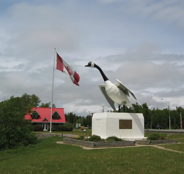
This section also marks the start of the TCH’s string of icons, beginning with the “big nickel” on Sudbury’s outskirts to mark that city’s ongoing role as one of the world’s biggest nickel producers. North of Sault Ste. Marie (with its world-renowned Agawa Canyon tour train), the TCH encounters Wawa’s famous giant goose, the third on the site and built to celebrate overcoming the highway’s last gap. (The first goose failed to weather the elements and rests near a motel in town.)
The iconic Canada goose statue at Wawa, Ontario, symbolizes the point of completion for the Trans-Canada Highway.
The section of road between “the Soo” and this former iron-mining town was among the most difficult to build and, in 1966, was the last to be opened. The hills and lake vistas along the road between the Soo and Wawa mark the start of one of Canada’s most scenic drives.
From Wawa (Anishinaabe for “wild goose” or “Land of the Big Goose”), the TCH cuts inland to the CPR divisional town of White River. It was on the platform of the White River railway station in 1914 that a Canadian army veterinarian, Captain Harry Colebourn, purchased a bear cub to be a mascot for his regiment, naming her Winnipeg after his hometown. In England, he donated the friendly cub, by then nicknamed Winnie, to the London Zoo. There a young boy named Christopher Robin Milne, whose favourite toy was a stuffed bear, became enamoured of the creature, inspiring his father, A.A. Milne, to create a series of children’s books featuring an anthropomorphic character named Winnie-the-Pooh.
It is no surprise, then, that the town’s newest roadside icon is a statue of the friendly little bear, having replaced the infamous thermometer that had proclaimed (incorrectly) that White River was the home of Canada’s coldest temperature ever recorded.
Heading ever more westerly, passing rock outcrops and endless woodlands, the TCH comes to a more recent industrial area where Marathon, Terrace Bay, and Red Rock all emerged as smoky pulp mill towns in the 1950s. The 1980s marked a new gold rush to the Hemlo goldfields near Marathon, where the mines, most now depleted, retain their ghostly headframes by the road.
Here, too, the TCH reconnects with the cliff-lined Lake Superior shoreline, providing travellers with one of Canada’s more scenic and world-renowned drives. It is an area that inspired Group of Seven artists such as Lawren Harris to create some of Canada’s most iconic (and valuable) works of art.
This brings the TCH to the “famous” Nipigon bridge. A short distance east of the railway town of Nipigon, the two branches of the TCH, 11 and 17, join up again. Together they cross the canyon of the Nipigon River on a bridge that marks the only link between the road networks of eastern and western Canada. Any problem on this vital structure would sever the country’s entire road network, which, in January 2016, is exactly what happened.
Following a prolonged but not unusual cold snap, the western end of the newly replaced two-lane span suddenly lurched sixty centimetres into the air, rendering the entire bridge impassible. All of Canada’s cross-country traffic came to a sudden halt at the Nipigon River. Later investigation blamed the contractors for improperly tightened bolts, poorly designed shoe plates, and a lack of rotation in the bearings. The bridge’s closure forced 1,300 trucks each day to endure a lengthy detour around the American south shore of Lake Superior, having to pass through two customs checkpoints. A temporary fix allowed the bridge to partially reopen a month later.
From Nipigon to Manitoba, the TCH becomes a tedious landscape of rock outcrops, boreal forest, and small lakes, interrupted only by the sprawling city of Thunder Bay and the foaming torrent of Kakabeka Falls. Interesting side trips, however, lead to the Sleeping Giant rock formation, a soaring limestone mesa that stabs into Lake Superior, and the ghost town of Silver Islet. Other ventures lead to Ontario’s Grand Canyon, the Ouimet Canyon, and to the Panorama Amethyst mine, the last of the area’s famous working amethyst mines.
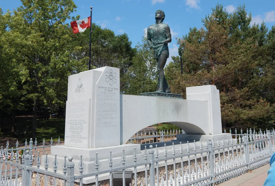
There is another TCH icon here, and that is the monument to Terry Fox. Following the TCH for the most part, in 1980 this athlete, who had lost part of his right leg to cancer, ran a marathon a day to raise money for cancer research. The monument marks the site where recurring cancer forced him to end his journey. He died the following year in Vancouver. He was just twenty-two. Over the following years, his courageous effort has resulted in the annual worldwide Terry Fox Run, which has raised millions of dollars for cancer research.
In 1980 Terry Fox, who had lost his leg to cancer, famously began a cross-Canada run, the Marathon of Hope, to raise money for cancer research. Terry’s run came to a tragic end just outside of Thunder Bay when his cancer returned, forcing him to abandon his quest. Terry eventually succumbed to the disease, dying in June 1981. This monument in Thunder Bay was erected in his memory.
Northwest of Thunder Bay, Dryden marks the location of the infamous paper mill that leaked poisonous mercury into the English-Wabigoon River system in the 1960s and early 1970s, endangering the lives of the Indigenous Peoples that depend on its waters. It has yet to be completely cleaned up.
Eventually, the TCH makes its wa...