eBook - ePub
Plate Tectonics
An Insider's History Of The Modern Theory Of The Earth
Naomi Oreskes
This is a test
- 448 Seiten
- English
- ePUB (handyfreundlich)
- Über iOS und Android verfügbar
eBook - ePub
Plate Tectonics
An Insider's History Of The Modern Theory Of The Earth
Naomi Oreskes
Angaben zum Buch
Buchvorschau
Inhaltsverzeichnis
Quellenangaben
Über dieses Buch
This book provides an overview of the history of plate tectonics, including in-context definitions of the key terms. It explains how the forerunners of the theory and how scientists working at the key academic institutions competed and collaborated until the theory coalesced.
Häufig gestellte Fragen
Wie kann ich mein Abo kündigen?
Gehe einfach zum Kontobereich in den Einstellungen und klicke auf „Abo kündigen“ – ganz einfach. Nachdem du gekündigt hast, bleibt deine Mitgliedschaft für den verbleibenden Abozeitraum, den du bereits bezahlt hast, aktiv. Mehr Informationen hier.
(Wie) Kann ich Bücher herunterladen?
Derzeit stehen all unsere auf Mobilgeräte reagierenden ePub-Bücher zum Download über die App zur Verfügung. Die meisten unserer PDFs stehen ebenfalls zum Download bereit; wir arbeiten daran, auch die übrigen PDFs zum Download anzubieten, bei denen dies aktuell noch nicht möglich ist. Weitere Informationen hier.
Welcher Unterschied besteht bei den Preisen zwischen den Aboplänen?
Mit beiden Aboplänen erhältst du vollen Zugang zur Bibliothek und allen Funktionen von Perlego. Die einzigen Unterschiede bestehen im Preis und dem Abozeitraum: Mit dem Jahresabo sparst du auf 12 Monate gerechnet im Vergleich zum Monatsabo rund 30 %.
Was ist Perlego?
Wir sind ein Online-Abodienst für Lehrbücher, bei dem du für weniger als den Preis eines einzelnen Buches pro Monat Zugang zu einer ganzen Online-Bibliothek erhältst. Mit über 1 Million Büchern zu über 1.000 verschiedenen Themen haben wir bestimmt alles, was du brauchst! Weitere Informationen hier.
Unterstützt Perlego Text-zu-Sprache?
Achte auf das Symbol zum Vorlesen in deinem nächsten Buch, um zu sehen, ob du es dir auch anhören kannst. Bei diesem Tool wird dir Text laut vorgelesen, wobei der Text beim Vorlesen auch grafisch hervorgehoben wird. Du kannst das Vorlesen jederzeit anhalten, beschleunigen und verlangsamen. Weitere Informationen hier.
Ist Plate Tectonics als Online-PDF/ePub verfügbar?
Ja, du hast Zugang zu Plate Tectonics von Naomi Oreskes im PDF- und/oder ePub-Format sowie zu anderen beliebten Büchern aus Ciencias físicas & Física. Aus unserem Katalog stehen dir über 1 Million Bücher zur Verfügung.
Information
PART I
THE HISTORICAL BACKGROUND
The idea that continents move was first seriously considered in the early 20th century, but it took scientists 40 years to decide that it was true. Part I describes the historical background to this question: how scientists first pondered the question of crustal mobility, why they rejected the idea the first time around, and how they ultimately came back to it with new evidence, new ideas, and a global model of how it works.
CHAPTER 1
FROM CONTINENTAL DRIFT TO PLATE TECTONICS
SINCE THE 16TH CENTURY, CARTOGRAPHERS HAVE NOTICED THE jigsaw-puzzle fit of the continental edges.1 Since the 19th century, geologists have known that some fossil plants and animals are extraordinarily similar across the globe, and some sequences of rock formations in distant continents are also strikingly alike. At the turn of the 20th century, Austrian geologist Eduard Suess proposed the theory of Gondwanaland to account for these similarities: that a giant supercontinent had once covered much or all of Earth’s surface before breaking apart to form continents and ocean basins. A few years later, German meteorologist Alfred Wegener suggested an alternative explanation: continental drift. The paleontological patterns and jigsaw-puzzle fit could be explained if the continents had migrated across the earth’s surface, sometimes joining together, sometimes breaking apart. Wegener argued that for several hundred million years during the late Paleozoic and Mesozoic eras (200 million to 300 million years ago), the continents were united into a supercontinent that he labeled Pangea—all Earth. Continental drift would also explain paleoclimate change, as continents drifted through different climate zones and ocean circulation was altered by the changing distribution of land and sea, while the interactions of rifting and drifting land masses provided a mechanism for the origins of mountains, volcanoes, and earthquakes.
Continental drift was not accepted when first proposed, but in the 1960s it became a cornerstone of the new global theory of plate tectonics. The motion of land masses is now explained as a consequence of moving “plates”—large fragments of the earth’s surface layer in which the continents are embedded. These plates comprise the upper 45 to 60 miles (80 to 100 kilometers) of the earth’s surface (now called the lithosphere), and move at a rate of 1 to 4 inches (3 to 10 centimeters) per year. Earthquakes, volcanoes, and mountains are concentrated on plate margins where two plates collide, split apart, or slide past one another. Moreover, the global configuration of continents and oceans is constantly changing. As Wegener suggested, the breakup of Pangea produced the configuration of continents and oceans that we have today.
BEFORE CONTINENTAL DRIFT: VERSIONS OF CONTRACTION THEORY
One of the central scientific questions of 19th-century geology was the origin of mountains. How were they formed? What process squeezed and folded rocks like putty? What made the earth’s surface move? Most theories invoked terrestrial contraction as a causal force. It was widely believed that Earth had formed as a hot, incandescent body, and had been steadily cooling since the beginning of geological time. Because most materials contract as they cool, it seemed logical to assume that Earth had been contracting as it cooled, too. As it did, its surface would have deformed, producing mountains.
In Europe, Austrian geologist Edward Suess (1831–1914) popularized the image of Earth as a drying apple: as the planet contracted, its surface wrinkled to accommodate the diminished surface area. Suess assumed that Earth’s initial crust was continuous, but broke apart as the interior shrunk. The collapsed portions formed the ocean basins; the remaining elevated portions formed the continents. With continued cooling, the original continents became unstable and collapsed to form the next generation of ocean floor, and what had formerly been ocean now became dry land. Over the course of geological history, there would be a continual interchange of land and sea, a periodic rearrangement of the land masses.
The interchangeability of continents and oceans explained a number of other perplexing geological observations, such as the presence of marine fossils on land (which had long before puzzled Leonardo Da Vinci) and the extensive interleaving of marine and terrestrial sediments in the stratigraphic record. Suess’ theory also explained the striking similarities of fossils in parts of India, Africa, and South America. Indeed, in some cases the fossils seemed to be identical, even though they were found thousands of miles apart. These similarities had been recognized since the mid-century, but they had been made newly problematic by Darwin’s theory of evolution. If plants and animals had evolved independently in different places within diverse environments, then why did they look so similar? Suess explained this conundrum by attributing these similar species to an early geological age when the continents were contiguous in an ancient supercontinent called Gondwanaland.2
Suess’ theory was widely discussed and to varying degrees accepted in Europe, but in North America geologist James Dwight Dana (1813–1895) had developed a different version of contraction theory. Dana suggested that the continents had formed early in earth history, when low-temperature minerals such as quartz and feldspar had solidified. Then the globe continued to cool and contract, until the high-temperature minerals such as olivine and pyroxene finally solidified: on the moon, to form the lunar craters; on Earth, to form the ocean basins. As contraction continued after Earth was solid, its surface began to deform. The boundaries between continents and oceans took up most of the pressure—like the seams on a dress—and so mountains began to form along continental margins. With continued contraction came continued deformation, but with the continents and oceans always in the same relative positions.3 Although Dana’s theory was a version of contraction, it came to be known as permanence theory, because it viewed continents and oceans as globally permanent features.
In North America, permanence theory was linked to the theory of geosynclines: subsiding sedimentary basins along continental margins. This idea was developed primarily by James Hall (1811–1889), state paleontologist of New York and the first president of the Geological Society of America (1889). Hall noted that, beneath the forest cover, the Appalachian mountains were built up of folded layers of shallow-water sedimentary rocks, thousands of feet thick. How did these sequences of shallow-water deposits form? How were they folded and uplifted into mountains? Hall suggested that materials eroded off the continents accumulated in the adjacent marginal basins, causing the basins to subside. Subsidence allowed more sediments to accumulate, causing more subsidence, until finally the weight of the pile caused the sediments to be heated, converted to rock, and then uplifted into mountains.4 (The process of uplift, or mountain-building, is called orogeny.) Dana modified Hall’s view by arguing that thick sedimentary piles were not the cause of subsidence but the result of it. Either way the theory provided a concise explanation of how thick sequences of shallow-water rocks could accumulate, but was vague on the question of how they were transformed into mountain belts.
CONTINENTAL DRIFT AS ALTERNATIVE TO CONTRACTION THEORY
In the early 20th century, contraction theory was challenged by three independent lines of evidence. The first came from field mapping. Nineteenth-century geologists had worked in great detail to determine the structure of mountain belts, particularly the Swiss Alps and the North American Appalachians. When they mapped the folded sequences of rocks in these regions, they found the folds to be so extensive that if one could unfold them the rock layers would extend for hundreds of miles. Impossibly huge amounts of terrestrial contraction would have to be involved. Geologists began to doubt contraction theory as an explanation for the origins of mountains.
The second line of evidence came from geodesy—the science of the shape (or figure) of the earth. While field geologists were unraveling the structure of the Alps and Appalachians, cartographers with the Great Trignometrical Survey of India were making geodetic measurements to produce accurate maps of British colonial holdings.5 In the early 1850s, Colonel (later Sir) George Everest, the surveyor-general of India, discovered a discrepancy in the measured distance between two stations, Kaliana and Kalianpur, 370 miles (600 kilometers) apart. When measured on the basis of surveyor’s triangulations, the latitude difference was five seconds greater than when computed on the basis of astronomical observation. Everest thought the difference might be due to the gravitational attraction of the Himalayas on the surveyors’ plumb bobs, and enlisted John Pratt (1809–1871), a Cambridge-trained mathematician and the archdeacon of Calcutta, to examine the problem. Pratt calculated the expected gravitational effect of the mountains, and discovered that the discrepancy was less than it should have been: it was as if part of the mountains were missing. Pratt proposed that the observed effects could be explained if the surface topography of the mountains were somehow compensated by a deficit of mass beneath them—an idea that came to be known as isostasy, or “equal standing.” In the early 20th century, isostasy was confirmed by detailed geodetic and gravity measurements across the United States. John Hayford (1868–1925) and William Bowie (1872–1940), working at the U.S. Coast and Geodetic Survey, demonstrated that the distribution of gravity was most consistent with the assumption of isostasy, not just in mountain belts, but across the continents. Isostasy could be achieved either if the continents were less dense than the layers of rock beneath them, or if they had deep roots, like icebergs. Either way, they “floated” in the substrate beneath them, and therefore they could not sink to become ocean basins. Continents and oceans were not interchangeable.
Third, and most fundamental, physicists discovered radiogenic heat, which contradicted the basic assumption of contraction theory that the earth was steadily cooling. With contraction no longer assumed, earth scientists were motivated to search for other driving forces of deformation. By the 1920s, many considered the science to be in a state of crisis: with contraction theory discredited, how were geologists to account for the evidence of prior continental connections? How were they to reconcile the evidence from historical geology for the changing configuration of land masses with the apparent permanence of continents and oceans? This crisis was felt most acutely by European geologists who had accepted Suess’ theory, but Americans also realized that they faced a dilemma. A number of scientists began to put forward alternative theories of continental fragmentation or migration. Alfred Wegener (1880–1930) is the most significant, for his theory was the most widely discussed at the time, and the one that was later vindicated.
A pioneering meteorologist and author of an early text on the thermodynamics of the atmosphere, Wegener realized that paleoclimate change could be explained if continents had migrated across climate zones and the reconfiguration of land masses altered Earth’s climate patterns.6 However, continental drift was more than just a theory of paleoclimate change. Wegener explicitly presented his theory as a means to reconcile historical geology with isostasy: on the one hand, paleontological evidence that the continents had once been connected; on the other, geodetic evidence that they could not be connected in the way European contractionists had supposed by now-sunken crust. Wegener’s answer was to reconnect the continents by moving them laterally.
Wegener’s theory was widely discussed in the 1920s and early 1930s. It was also hotly rejected, particularly by geologists in the United States, who labeled it bad science. The standard explanation for the rejection of continental drift is the lack of a causal mechanism, but this explanation is false. There was a spirited and rigorous international debate over the possible mechanisms of continental migration, which ultimately settled on the same explanation generally accepted today for plate tectonics: convection currents in the earth’s mantle.
The debate over the mechanism of continental drift centered on the implications of isostasy. If continents floated in a denser substrate, then this substrate had to be either fluid or plastic, and continents could at least in principle move through it. There was good evidence that this was indeed the case: in Scandinavia, geologists had documented a progressive uplift of Finland and Scandinavia since the end of the Pleistocene epoch (10,000 years ago), which they called the Fennoscandian rebound. The accepted explanation for this phenomenon was that during the Pleistocene epoch, the region had been depressed under the weight of a thick sheet of glacial ice; as the ice gradually melted, the land surface gradually rebounded. This provided empirical evidence that continents could move through the substrate in which they were embedded, at least in the vertical direction and at least during the Pleistocene. However, in Scandinavia the cause of motion was generally agreed: first the weight of glacial ice, then the pressure release upon its removal. What force would cause horizontal movement? Would the substrate respond to horizontal movement as it did to vertical movement? Debate over the mechanisms of drift concentrated on the long-term behavior of the substrate and the forces that could cause continents to move laterally.
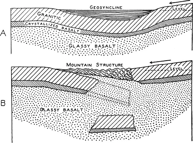
Reginald Daly’s mechanism of continental drift by gravity sliding. Reprinted with permission of Scribner, a Division of Simon and Schuster, from Our Mobile Earth by Reginald A. Daly, copyright © 1926 by Charles Scribner’s Sons, renewed 1954 by Reginald A. Daly, on p. 269.
In the United States, the question was addressed by Harvard geology professor Reginald A. Daly (1871–1957), North America’s strongest defender of continental drift. Daly argued that the key to tectonic problems was to be found in the earth’s layered structure. Advances in seismology suggested that the earth contained three major layers: crust, substrate (or mantle), and core. The substrate, he suggested, might be glassy, and therefore could flow in response to long-term stress just as old plates of glass gradually thicken at their lower edges and glassy lavas flow downhill. Continents might do the same. Building on the geosyncline concept of Dana and Hall, Daly suggested that sedimentation along the continental margins resulted in subtle elevation differences, which in turn produced gravitational instabilities. Eventually, the continent could rupture, sliding down over the glassy substrate under the force of gravity. The sliding fragment would then override the other half—an early suggestion of subduction—and, over time, the accumulation of small increments of sliding would result in global continental drift.7
Daly urged his American colleagues to take up the question of drift, but few did. Reaction in Europe was more favorable. Irish geologist John Joly (1857–1933) linked the question to discoveries in radioactivity. Trained as a physicist, Joly had demonstrated that the commonly observed dark rings in micas—so-called pleochroic haloes—were caused by radiation damage from tiny inclusions of uranium- and thorium-bearing minerals, such as apatite. Radioactive elements were therefore ubiquitous in rocks, suggesting that radiogenic heat was also ubiquitous. If it was, then it could be a force for geological change. Joly proposed that as radiogenic heat accumulated, the substrate would begin to melt. During these episodes of melting, the continents could move under the influence of small forces, such as minor gravitational effects, that would otherwise...
Inhaltsverzeichnis
- Cover
- Half Title
- Title Page
- Copyright Page
- Dedication
- Table of Contents
- Acknowledgments
- Preface: History and Memory
- PART I THE HISTORICAL BACKGROUND
- PART II THE EARLY WORK: FROM PALEOMAGNETISM TO SEA FLOOR SPREADING
- PART III HEAT FLOW AND SEISMOLOGY
- PART IV THE PLATE MODEL
- PART V FROM THE OCEANS TO THE CONTINENTS
- EPILOGUE: CONTINENTS REALLY DO MOVE
- Notes
- Further Reading
- Index
Zitierstile für Plate Tectonics
APA 6 Citation
Oreskes, N. (2018). Plate Tectonics (1st ed.). CRC Press. Retrieved from https://www.perlego.com/book/1597881/plate-tectonics-an-insiders-history-of-the-modern-theory-of-the-earth-pdf (Original work published 2018)
Chicago Citation
Oreskes, Naomi. (2018) 2018. Plate Tectonics. 1st ed. CRC Press. https://www.perlego.com/book/1597881/plate-tectonics-an-insiders-history-of-the-modern-theory-of-the-earth-pdf.
Harvard Citation
Oreskes, N. (2018) Plate Tectonics. 1st edn. CRC Press. Available at: https://www.perlego.com/book/1597881/plate-tectonics-an-insiders-history-of-the-modern-theory-of-the-earth-pdf (Accessed: 14 October 2022).
MLA 7 Citation
Oreskes, Naomi. Plate Tectonics. 1st ed. CRC Press, 2018. Web. 14 Oct. 2022.