Map making and, ultimately, map thinking is ubiquitous across literature, cosmology, mathematics, psychology, and genetics. We partition, summarize, organize, and clarify our world via spatialized representations.Our maps and, more generally, our representations seduce and persuade; they build and destroy. They are the ultimate record of empires and of our evolving comprehension of our world.This bookis about the promises and perils of map thinking. Maps are purpose-driven abstractions, discarding detail to highlight only particular features of a territory. By preserving certain features at the expense of others, they can be used to reinforce a privileged position. When Maps Become the World shows us how the scientific theories, models, and concepts we use to intervene in the world function as maps, and explores the consequences of this, both good and bad.We increasingly understand the world around us in terms of models, to the extent that we often take the models for reality. Winther explains how in time, our historical representations in science, in cartography, and in our stories about ourselves replace individual memories and become dominant social narratives—theybecomereality, and they can remake the world.
Häufig gestellte Fragen
Wie kann ich mein Abo kündigen?
Gehe einfach zum Kontobereich in den Einstellungen und klicke auf „Abo kündigen“ – ganz einfach. Nachdem du gekündigt hast, bleibt deine Mitgliedschaft für den verbleibenden Abozeitraum, den du bereits bezahlt hast, aktiv. Mehr Informationen hier.
(Wie) Kann ich Bücher herunterladen?
Derzeit stehen all unsere auf Mobilgeräte reagierenden ePub-Bücher zum Download über die App zur Verfügung. Die meisten unserer PDFs stehen ebenfalls zum Download bereit; wir arbeiten daran, auch die übrigen PDFs zum Download anzubieten, bei denen dies aktuell noch nicht möglich ist. Weitere Informationen hier.
Welcher Unterschied besteht bei den Preisen zwischen den Aboplänen?
Mit beiden Aboplänen erhältst du vollen Zugang zur Bibliothek und allen Funktionen von Perlego. Die einzigen Unterschiede bestehen im Preis und dem Abozeitraum: Mit dem Jahresabo sparst du auf 12 Monate gerechnet im Vergleich zum Monatsabo rund 30 %.
Was ist Perlego?
Wir sind ein Online-Abodienst für Lehrbücher, bei dem du für weniger als den Preis eines einzelnen Buches pro Monat Zugang zu einer ganzen Online-Bibliothek erhältst. Mit über 1 Million Büchern zu über 1.000 verschiedenen Themen haben wir bestimmt alles, was du brauchst! Weitere Informationen hier.
Unterstützt Perlego Text-zu-Sprache?
Achte auf das Symbol zum Vorlesen in deinem nächsten Buch, um zu sehen, ob du es dir auch anhören kannst. Bei diesem Tool wird dir Text laut vorgelesen, wobei der Text beim Vorlesen auch grafisch hervorgehoben wird. Du kannst das Vorlesen jederzeit anhalten, beschleunigen und verlangsamen. Weitere Informationen hier.
Ist When Maps Become the World als Online-PDF/ePub verfügbar?
Ja, du hast Zugang zu When Maps Become the World von Rasmus Grønfeldt Winther im PDF- und/oder ePub-Format sowie zu anderen beliebten Büchern aus Philosophy & Philosophy History & Theory. Aus unserem Katalog stehen dir über 1 Million Bücher zur Verfügung.
Maps help writers build new worlds, and then open these worlds to the reader. Consider the map of Middle Earth in J. R. R. Tolkien’s The Lord of the Rings; Robert Louis Stevenson’s map of Treasure Island; or R2-D2’s and BB-8’s complementary holographic maps in Star Wars: The Force Awakens. Ocean charts, paper maps, digital maps, and other cartographic objects are as intuitive and familiar as they are disregarded and forgotten, despite being fundamental to finding our way in the world.
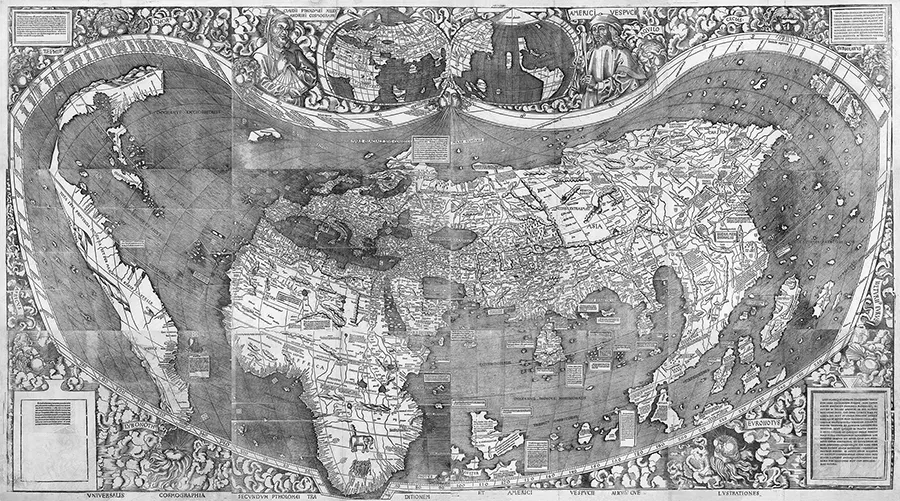
FIGURE 1.1. In 1507, Waldseemüller designed and completed an enormous map: 1.32 by 2.36 meters, in twelve sheets. The title, in English, is roughly A Universal Cosmography According to the Tradition of Ptolemy and the Discoveries of Amerigo Vespucci and Others. (Geography and Map Division, Library of Congress.)
Ponder, for instance, J. L. Borges’s “On Exactitude in Science” (1946), with its map as big as an entire empire, which highlights the practicality—even necessity—of reducing scale and abstracting symbolism. While Borges’s very short story will be familiar to many, it is worth bearing in mind:
In that Empire, the Art of Cartography attained such Perfection that the map of a single Province occupied the entirety of a City, and the map of the Empire, the entirety of a Province. In time, those Unconscionable Maps no longer satisfied, and the Cartographers Guilds struck a Map of the Empire whose size was that of the Empire, and which coincided point for point with it. The following Generations, who were not so fond of the Study of Cartography as their Forebears had been, saw that that vast Map was Useless, and not without some Pitilessness was it, that they delivered it up to the Inclemencies of Sun and Winters. In the Deserts of the West, still today, there are Tattered Ruins of that Map, inhabited by Animals and Beggars; in all the Land there is no other Relic of the Disciplines of Geography. —Suárez Miranda, Viajes de varones prudentes, Libro IV, Cap. XLV, Lérida, 16581
A map the same size as the territory, a one-to-one scaled map, that also copies the entire terrain will fail to subtract irrelevant and noisy features. Due to its magnitude, level of detail, and sheer practical unwieldiness, Borges’s map of the empire is useless in guiding your eye, mind, and feet through a particular neighborhood or city. A perfectly realistic map is a useless representation.
In Italo Calvino’s work of fiction Invisible Cities (1974; Le città invisibili, 1972), Marco Polo recounts to the Mongol emperor, Kublai Khan, the many cities he has visited in both dreams and reality. In the chaotic and smelly city of Eudoxia, according to Polo, there is a symmetrical, patterned carpet.2 Each place in the carpet purportedly corresponds to a place in the city, and each inhabitant reads into the carpet her or his unique perspective. An oracle had told that either the city or the carpet is a map of the entire universe, the other merely an approximate reflection; but neither the inhabitants nor we, the readers, know which is the universe map and which is the reflection. A map represents the territory, and structural analogies between the carpet and the city—and between them and the universe writ large—allow for novel and informative representation relations to emerge.
Consider how Ursula Le Guin’s pathbreaking Earthsea series starts with a map that she herself drew (plate 1), as she reports in an oral interview:
I had written a couple of short stories, very light short stories that took place on these islands where there were wizards and dragons. And when I sort of began thinking about a book, these islands grew in, just boom, it sort of, this is a whole archipelago of islands, and now I draw the map. And so the first thing I did for the book was the map. And I’ve always used that map all six books.3
A map organizes the entire narrative, both for the author in the process of composition and for the reader in the process of comprehension. No story without a map.
Writing in Tom Sawyer Abroad, Mark Twain humorously satirizes the conflation of map and territory as Huck Finn and Tom Sawyer fly over the American Midwest in a balloon:
[Huck:] “I know by the color. We’re right over Illinois yet. And you can see for yourself that Indiana ain’t in sight.”
[Tom:] “I wonder what’s the matter with you, Huck. You know by the color?”
“Yes, of course I do.”
“What’s the color got to do with it?”
“It’s got everything to do with it. Illinois is green, Indiana is pink. You show me any pink down here, if you can. No sir; it’s green.”
“Indiana pink? Why, what a lie!”
“It ain’t no lie; I’ve seen it on the map, and it’s pink.”
You never see a person so aggravated and disgusted. He says:
“Well, if I was such a numbskull as you, Huck Finn, I would jump over. Seen it on the map! Huck Finn, did you reckon the States was the same color out-of-doors as they are on the map?”
“Tom Sawyer, what’s a map for? Ain’t it to learn you facts?”4
Huck’s sincere questions are striking. Perhaps we can forgive him for interpreting the map as the territory. But what if such errors become systemic, shared by many individuals? And what if such errors lead to harm or even death?
Borges’s map of the empire, Calvino’s carpet of Eudoxia, Le Guin’s map of Earthsea, and Mark Twain’s pink Indiana exemplify themes from When Maps Become the World: maps are abstractions discarding detail, focusing only on essential features of the territory. What is essential depends on one’s purposes. Moreover, we map because we have a deep spatial human cognitive and social capacity, and need. We orient ourselves in different kinds of spaces. Maps therefore represent their territories in spatial, multiple, and creative ways. But we also sometimes perniciously conflate and confuse map and territory. In order to realize that a map is not the territory, we can, for instance, consider multiple points of view on—multiple maps of—the same territory.
Literature occasionally goes further and explores the meaning and significance of maps and mapping for science and philosophy. For the philosopher—as for the self-aware writer, artist, creator, explorer, and responsible citizen—this realization allows the map to serve as an apt analogy for theory and model; as metaphor for how we know; and even as illustration of magic, mystery, and the beyond. In a sentence, this book is about the power and limitations of maps and mapping, including those ambitious and interconnected maps that we call scientific theories.
To lay the cartographic groundwork for our journey, this chapter explores my concept of “map thinking,” first theoretically, with sections on elements of map thinking and definitions of our central notion, “map,” and then through three actual cartographic objects. It concludes with some thoughts on digital mapping.
A History and Philosophy of Map Thinking
Visualize a simple paper street map of your favorite city. It can guide you to the museum, to the nearest park, or to a new grocery store. It speaks volumes. Conversely, a bad map serves no purpose but frustration and a disoriented loss of time and direction. Maps can be wrong, or may not fulfill your purposes. But let us take a minute to focus on that street map that guides you properly without incident. Who designed and produced your useful map? According to which data, techniques, and conventions was it made? How did the mapmakers simplify and abstract the teeming city? A well-designed street map is an effective tool, not just a lifeless visual archetype.5
In our mundane map use, we may not care about such questions, since we wish only to get from point A to point B in the most timely or easiest fashion possible. But I want to invite you to become a map thinker—someone who seeks to answer these questions and more. Do maps entrance and enchant you? Did you pore over an atlas for hours at home as a child, traveling continent to continent in your imagination? Let us traverse a new territory in which we investigate the hidden power of mapping within realms of being and action.
The Nature of Map Thinking
Map thinking refers to philosophical reflection concerning what standard geographic maps are and how they are made and used. The purpose of such contemplation is to explore the promises and limits of representations—cartographic and beyond. Representations in general are not just visual, but also linguistic, physical, and mathematical; they proliferate across the sciences, the arts, and everyday life. You might be more comfortable with precise mathematical representations than with visual ones. Your friend might prefer poetry, literature, or other linguistic representations. Important lessons about senses other than visual can be learned from cartographic representations.
Map thinking massages the imagination; excavates hidden assumptions; challenges and synthesizes dualisms; and invites us to reflect on space and time—including the future. In this book, map thinking is used to develop an analogy from representation in the domain of cartography to representation in the domain of scientific theory.
Elements of Map Thinking
Map thinking involves four elements: cartography, mapping, map studies, and map analogizing.
Cartography. Cartography is the study and practice of “philos...
Inhaltsverzeichnis
Cover
Title Page
Copyright Page
Dedication
Contents
Preface
1. Introduction: Why Maps?
PART 1: PHILOSOPHY
PART 2: SCIENCE
Color illustrations
Appendix: Cognitive Map Exercise
References
Index
Footnotes
Zitierstile für When Maps Become the World
APA 6 Citation
Winther, R. G. (2020). When Maps Become the World ([edition unavailable]). The University of Chicago Press. Retrieved from https://www.perlego.com/book/1851435/when-maps-become-the-world-pdf (Original work published 2020)
Chicago Citation
Winther, Rasmus Grønfeldt. (2020) 2020. When Maps Become the World. [Edition unavailable]. The University of Chicago Press. https://www.perlego.com/book/1851435/when-maps-become-the-world-pdf.
Harvard Citation
Winther, R. G. (2020) When Maps Become the World. [edition unavailable]. The University of Chicago Press. Available at: https://www.perlego.com/book/1851435/when-maps-become-the-world-pdf (Accessed: 15 October 2022).
MLA 7 Citation
Winther, Rasmus Grønfeldt. When Maps Become the World. [edition unavailable]. The University of Chicago Press, 2020. Web. 15 Oct. 2022.