![]()
ONE
‘AN ENCHANTED VISION’
When we saw so many cities and villages built in the water and other great towns on dry land and that straight and level Causeway going towards Mexico, we were amazed and said that it was like the enchantments they tell of in the legend of Amadis, on account of the great towers and cues [temples] and buildings rising from the water, and all built of masonry. And some of our soldiers even asked whether the things that we saw were not a dream.1
With these words the Spanish conquistador Bernal Díaz del Castillo recalled his first eye-opening view of the great Aztec city of Tenochtitlan and its wondrous surroundings. This foot soldier had come to the West Indies from Spain in 1514 when he was about nineteen years old, and joined Hernando Cortés’s forces in Cuba in 1519.2 After landing on the Mexican coast near present-day Veracruz in April of that year, this military contingent worked its way inland, in and out of Aztec imperial boundaries, months later to arrive at the vast urban expanse of the Basin of Mexico. They were spellbound as the gleaming panorama unfolded before them. What were they thinking? What were they feeling? They had never seen anything quite like this, but necessarily based their impressions on their own world view. Where did that come from? What vision of the world did they carry with them as they walked straight into this astonishing and unfamiliar land?
Bernal Díaz and his Spanish colleagues were steeped in medieval and early modern Spanish traditions.3 These included their own recent history of conflicts between Spaniards and Moors that fostered aspirations of military valour, expectations of political loyalty, ideals of chivalry and honour, and a firm devotion to Christianity. These strongly grounded historical traditions were augmented by mythical or semi-mythical sagas of adventure and knightly courage. Among the most popular of these were the enthralling tales of Amadis of Gaul (reminiscent of the stories of King Arthur), brought to mind by Bernal Díaz as he gaped at the Aztec capital city. These romantic tales of derring-do follow the exploits of the seemingly invincible knight Amadis as he travels hither and thither about the countryside, enthusiastically vanquishing defiant enemies and conquering glorious cities. The Amadis tales speak often of beautiful towers, impregnable fortresses, elegant palace rooms and courtyards, and sweeping landscapes. One particular ‘Amadis moment’ may have popped into this foot soldier’s mind as he gazed upon Tenochtitlan:
and on the fifth day they found themselves near a very strong castle that overlooked salt water, and the castle was called Bradoyd, and it was the most beautiful in all that land, and was located on a high cliff, and on one side flowed that water and on the other there was a great marsh; and on the water side one could enter only by boat, and on the side toward the marsh there was a causeway so wide that one cart could go and another come, but at the entrance to the causeway there was a narrow bridge and it was a drawbridge.4
In November 1519 Bernal Díaz seems to have envisioned himself in such a setting, even though he wrote and rewrote his recollections from the 1550s until his death in 1584, many years after the events and personal experiences he describes in such colourful detail. And he sounds right out of the tales of Amadis when he states that one of his major goals in writing his account was to ‘extol the adventures which we met with and the heroic deeds we accomplished during the conquest of New Spain and its provinces’.5 These romantic ideals were offset by intense religious beliefs and practical aspirations of wealth in portable goods (especially gold) and control over new lands and labour to work those lands. Clearly the conquistadores were highly motivated and brought with them a constellation of preconceptions and ambitions as they entered this challenging and exotic land.
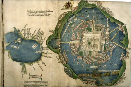
The 1524 Nuremberg Map of Tenochtitlan
Within a year Bernal Díaz’s ‘enchanted vision’ was laid out in a map that encompassed the plan of Tenochtitlan and its surrounding lacustrine and urban landscape. The conquistadores entered this land along the southern causeway (on the left side of the map), having spent the night before in the lakeside city of Ixtapalapa (labelled Iztapalapa). Envision the Spaniards and the native allies they had collected along their journey from the coast, warily riding and walking along the broad causeway, passing multitudes of gawking people in canoes. They persevered step after step past flat-roofed houses and lofty temples, into the mysterious depths of the greatest city of the Aztec known world.
This renowned map was reportedly sent by Cortés with his second letter to the king of Spain in October 1520, almost ten months before the actual fall of the city to the Spaniards and their native allies. The map saw the light of day in Nuremberg in 1524 when it was published as a woodcut, created by a European craftsman and accompanying a Latin publication of Cortés’s sensational second letter. It was designed to appeal and relate to a European audience, hence the medieval-looking towers, domes and spires; the alphabetic glosses; a wicker dyke; houses drawn in perspective (a style not used in pre-Spanish Aztec art); a Classical-style sculpture; two lions among the native zoo animals; a small cross attached to the great temple; and a prominent Habsburg flag. In this colour version of the map, the roofs of the houses are red-tiled. Overall the map depicts an orderly urban world, one that a European viewer would understand as ‘civilized’. But ‘civilized’ is juxtaposed with ‘barbaric’ with the inclusion of manifestations of human sacrifice: a decapitated sculpture and two ominous-looking skull racks are conspicuous in the very heart of the city. Familiar but exotic – a publisher’s dream.
There are convincing indications that the original prototype map was composed by an Aztec scribe. The map is schematic and focuses on balance and symmetry (native preoccupations), with no particular attention to distances or scale. In actuality, the city did not sit in the middle of the lake. Yet the map clearly features the city as central and dominant: it is shown as the axis mundi, as the Aztecs truly conceived it. It was the very centre of their conceptual terrestrial and cosmic world, and it makes sense that the map depicts all roads leading to the centre of this city, and particularly to its monumental temple. The precise alignment of the great temple and the division of the city into quarters are characteristically indigenous and all-important to their conception of their place in the natural and supernatural universe. Also, there are features in the map that are unlikely to have been observed or understood by the Spaniards. For instance, the sun appears in the gap between the main twin temples, perfectly poised as it would have been observed by the Aztecs during its rising at the equinoxes. And details such as the exact locations of the great Tlatelolco market (labelled ‘Foru[m]’), the spring to the west that served as the source of their aqueduct, and the prominent dyke on the eastern side of the lake all appear in their proper places but were not located in Cortés’s second letter. Finally, west is at the top of the map, corresponding to other indigenous and indigenous-style maps from sixteenth-century central Mexico. With all of this in mind, the best-supported conclusion is that the German craftsman who created the woodcut worked from an indigenous prototype, embellishing it with his familiar buildings and other European features.6
The 1524 Nuremberg Map of Tenochtitlan.
This one map weaves together indigenous and European ideas and depictions of geographic space. It is an Aztec conception redesigned to suit European precepts and stylistic understandings. The map is a hybrid, an intricate blend. It provides a good starting-point to pursue a broad overview of landscapes, cities and towns, and the native people encountered by the Spaniards. But it is just one side of the story; as much as possible, the remainder of this book focuses on Aztec culture from the vantage point of the Aztecs themselves.
Landscapes
The lands that the Spanish conquistadores encountered on their trek from the Gulf Coast to highland Tenochtitlan were diverse and expansive: sand dunes and a broad coastal plain gave way to low-lying humid and semi-humid hills and then to more impressive mountains and deep barrancas (gorges), and on to dry stretches and broad, heavily populated plateaus. During their audacious journey the Spaniards experienced something of a microcosm of the Aztec imperial domain. They traversed hot tropical lowlands, encountered small communities nestled in the niches of verdant hillsides, marched more forthrightly across broad plains, weathered the travails of snowy mountain passes (even in August), and finally cast their eyes on the lake-dominated Basin of Mexico. While much of this was unfamiliar to the Spaniards, enough of it reminded them of their Spanish homeland in ‘mountains, valleys and fields’ and ‘fertility, size and the cold, as well as in many other things’ to prompt Cortés himself to suggest naming it New Spain.7 The Spaniards were cognizant of the locations of cities, fortifications and numbers of native warriors, for their immediate needs and survival. They also took notice of particular Spanish interests in the new land, such as sources of water, timber, ores and agricultural crops, in thoughts of a future occupation.
The Spaniards had travelled in and out of the eastern Aztec empire, but similar ecologies were mirrored throughout the Aztec domain to the north, west and south. In their trek, mostly during the summer rainy season, the Spaniards essentially described individual microenvironments (although not calling them that) without the benefit of seeing the broader environmental sweep. Looking at the big picture today, the area encompassed by the Aztec empire lay entirely within the tropics. Variations in ecologies were determined primarily by elevation and rainfall, both of which differed regionally and seasonally. Modern geographers divide this complex world into three distinct zones: tierra caliente, tierra templada and tierra fría. The hub of the Aztec empire lay in tierra fría.
Tierra caliente (hot land) encompasses coastal plains and low-lying inland hills and flatlands, from sea level to an elevation of 1,000 metres (3,280 ft). These lands are hot and humid and typically experience high rainfall, all of which result in environments full of abundant wildlife, lush tropical vegetation and plentiful crop yields (often two harvests of staple crops yearly). In Aztec times, these were (and continue to be) lands of prowling jaguars, screeching monkeys, elegant birds of brilliant plumage, and prolific riverine and marine life. The Aztecs valued these lands as sources for prized goods and commodities such as cacao, cotton, green-stones, colourful feathers and fine salt. In the latter years of the empire, Aztec rulers conquered many cities in this zone, reaping precious tributes to enhance their own power and livelihoods.
Tierra templada (temperate land) lay between 1,000 and 2,000 metres (6,560 ft) in elevation. Here are found landscapes ranging from rugged mountain terrain to more gentle hills to vast river valleys. Seasonal (May–October) rainfall is uneven in this zone, resulting in microenvironments varying from dry scrublands to semi-humid hills to expansive grasslands to mountain forests. Aztec imperial control over temperate lands extended mostly to the south, east and west of their heartland in the Basin of Mexico, and provided the empire with fairly reliable stores of staple crops (especially maize and beans) and a miscellany of resources including turquoise stones, gold, copper, pigments and dyes, and bees’ honey.
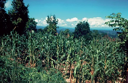
Maize field in a highland landscape.
Tierra fría (cold land) lies above 2,000 metres and encompasses highland plateaus, lake-dominated basins and majestic volcanic mountains. Native vegetation responds to the high altitude and somewhat undependable rainfall: flat grasslands, vast farmlands, scrub woodlands and pine-oak forests are all found in this zone. Seasonal rainfall is more unpredictable than at lower elevations, and farmers always faced a relatively short growing season and the danger of devastating frosts. Yet in Aztec times this zone was a noted breadbasket, the conquistadores marvelling at almost endless stretches of cultivated fields on the highland plateaus. Deer and rabbits were common, millions of migratory birds descended on the lakes in annual swarms, and abundant aquatic resources attracted people for thousands of years prior to and during Aztec ascendency. The Aztecs themselves lived in tierra fría, and extracted resources such as timber, reeds, obsidian and salt from their own heartland and from nearby conquered regions.
The highland Basin of Mexico, sitting at 2,236 metres (7,379 ft) in elevation at its lowest point and therefore in tierra fría, was the heart of the Aztec empire. It encompasses approximately 7,000 square kilometres (2,700 sq. mi.). It is a basin by virtue of its system of interior drainage: it is surrounded by lofty mountains as high as 5,465 metres (18,035 ft) that spill rainfall into the ...