
eBook - ePub
Holman Bible Atlas
Thomas V. Brisco
This is a test
Buch teilen
- 298 Seiten
- English
- ePUB (handyfreundlich)
- Über iOS und Android verfügbar
eBook - ePub
Holman Bible Atlas
Thomas V. Brisco
Angaben zum Buch
Buchvorschau
Inhaltsverzeichnis
Quellenangaben
Über dieses Buch
The Holman Bible Atlas offers a visual feast through which the reader can explore the world of the Bible. Utilizing 140 full color maps key to biblical events and 140 full color photographs illustrating the land, sites, and archaeology of the biblical world, the Atlas draws the reader into the biblical story.The Holman Bible Atlas begins with an introduction to the geography of the biblical world emphasizing the major physical features of the Ancient Near East with special attention given to the geographical regions of Palestine. Information about daily life and the role of archaeology in recovering ancient cultures are discussed.
Häufig gestellte Fragen
Wie kann ich mein Abo kündigen?
Gehe einfach zum Kontobereich in den Einstellungen und klicke auf „Abo kündigen“ – ganz einfach. Nachdem du gekündigt hast, bleibt deine Mitgliedschaft für den verbleibenden Abozeitraum, den du bereits bezahlt hast, aktiv. Mehr Informationen hier.
(Wie) Kann ich Bücher herunterladen?
Derzeit stehen all unsere auf Mobilgeräte reagierenden ePub-Bücher zum Download über die App zur Verfügung. Die meisten unserer PDFs stehen ebenfalls zum Download bereit; wir arbeiten daran, auch die übrigen PDFs zum Download anzubieten, bei denen dies aktuell noch nicht möglich ist. Weitere Informationen hier.
Welcher Unterschied besteht bei den Preisen zwischen den Aboplänen?
Mit beiden Aboplänen erhältst du vollen Zugang zur Bibliothek und allen Funktionen von Perlego. Die einzigen Unterschiede bestehen im Preis und dem Abozeitraum: Mit dem Jahresabo sparst du auf 12 Monate gerechnet im Vergleich zum Monatsabo rund 30 %.
Was ist Perlego?
Wir sind ein Online-Abodienst für Lehrbücher, bei dem du für weniger als den Preis eines einzelnen Buches pro Monat Zugang zu einer ganzen Online-Bibliothek erhältst. Mit über 1 Million Büchern zu über 1.000 verschiedenen Themen haben wir bestimmt alles, was du brauchst! Weitere Informationen hier.
Unterstützt Perlego Text-zu-Sprache?
Achte auf das Symbol zum Vorlesen in deinem nächsten Buch, um zu sehen, ob du es dir auch anhören kannst. Bei diesem Tool wird dir Text laut vorgelesen, wobei der Text beim Vorlesen auch grafisch hervorgehoben wird. Du kannst das Vorlesen jederzeit anhalten, beschleunigen und verlangsamen. Weitere Informationen hier.
Ist Holman Bible Atlas als Online-PDF/ePub verfügbar?
Ja, du hast Zugang zu Holman Bible Atlas von Thomas V. Brisco im PDF- und/oder ePub-Format sowie zu anderen beliebten Büchern aus Theology & Religion & Biblical Reference. Aus unserem Katalog stehen dir über 1 Million Bücher zur Verfügung.
Information
Thema
Theology & ReligionThema
Biblical ReferencePart One
THE BIBLICAL SETTING
INTRODUCTION
The Bible is an intensely geographical book as even a casual glance makes clear. It tells the story of God's redemptive work in human history. This story is revealed through the nation of Israel, the early church, and supremely in Jesus Christ. Specific geographical and cultural settings form the backdrop of this divine drama. Geographic position often plays a crucial part in the history of any people. Cultural influences, military and economic alliances, and the political importance of a given people all are determined to some degree by geographical location. Moreover, physical environment left a deep imprint on ancient societies since they were linked much more closely to the land than we are today. Terrain determined the location of villages and cities as well as the roads that linked them. Climate, soil conditions, and availability of water affected agriculture, location of settlements, everyday diet, even religious beliefs. The land provided the raw materials for household utensils, tools, weapons, houses, and other necessities of daily living. Not surprisingly then, students of the Bible must learn something of the physical setting of the biblical world to understand the story it narrates.
Chapter One
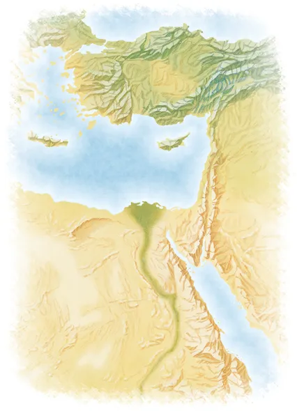
THE FACE OF THE ANCIENT NEAR EAST
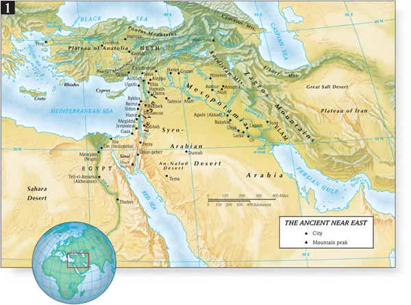
Most of the biblical drama unfolded in the Ancient Near East. Today the modern states of Egypt, Israel, Jordan, Saudi Arabia, Lebanon, Syria, Iraq, Iran, and Turkey occupy that area. The Ancient Near East has been called the “Cradle of Civilization” because many important cultural and technological advances took place there. We now know that comparable innovations occurred in other parts of the world, yet the Near East retains a central place in human history. There the influence of three continents—Africa, Asia, and Europe —converge.
The Fertile Crescent
James Breasted coined the phrase “Fertile Crescent” to describe a band of land where conditions favored the establishment of early agricultural settlements. Water, either from rainfall or irrigation, and a favorable climate encouraged the development of village life. Stretching northwest from the Persian Gulf (the “Lower Sea”), the crescent includes the lands bordering the Tigris and Euphrates Rivers known as Mesopotamia. In southern Turkey the crescent bends south along the eastern Mediterranean coast. Here lies a narrow strip of land caught between the sea and desert called the Levant. Ancient Syria formed the northern half of the Levant, while Palestine occupied the southern portion. The intrusion of the Syro-Arabian Desert from the south gives the crescent its characteristic shape, while mountain ranges (Taurus, Kurdistan, and Zagros Mountains) mark the limits to the north and east.
Beyond the Sinai, south of the Fertile Crescent, lay Egypt. Favored by nature with the Nile River and its abundant water, Egypt played a vital part in the Ancient Near East. From about 3200 B.C., Egypt, like Mesopotamia, became a powerful center of civilization. Historically, the cultures of Egypt and Mesopotamia dominated the history of the Ancient Near East, at least until the campaigns of Alexander the Great (334–323 B.C.).
The emergence of powerful and enduring civilizations in Egypt and Mesopotamia gave strategic importance to Palestine. Palestine was a “land bridge” linking the two great cultural centers. The major international route, the International Coastal Highway, crossed portions of Palestine. This geographical fact is crucial to the history of Palestine. As part of the corridor connecting Egypt and Mesopotamia, Palestine possessed a strategic importance far greater than its size or relatively few resources might suggest. Palestine sat astride the vital economic and military arteries of the Near East. Historically, this meant two things: (1) the people living in Palestine felt the imprint of many cultures, and (2) the major powers sought control of this small land.
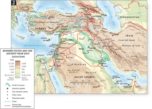
Mesopotamia: Home of Abraham
Mesopotamia was an integral part of the biblical landscape in many periods. Genesis locates Abraham's homeland in Mesopotamia (Gen. 11–12). Mesopotamian kings from Assyria and Babylon appear frequently in the historical and prophetic books of the Old Testament. Jewish captives from Jerusalem spent many years in exile near Babylon. Descendants of those exiles were present at Pentecost.
Mesopotamia, literally the land “between the rivers,” describes those lands bordering the Tigris and Euphrates Rivers. Today Iraq, northern Syria, and extreme southeastern Turkey occupy the area of ancient Mesopotamia. To the south and west the great expanse of the Syro-Arabian desert forms the border beyond which settled life based on agriculture is not possible. To the north and east, mountains ring Mesopotamia. In Bible times these mountains harbored less-advanced peoples who often threatened Mesopotamian kingdoms. Mesopotamia gave birth to many great civilizations, including the Sumerian, Akkadian, Babylonian, and Assyrian.
TIGRIS AND EUPHRATES
The Tigris and Euphrates Rivers dominate Mesopotamia. Both rivers originate in the high mountains of eastern Turkey and flow south-southeastward to the Persian Gulf. Large distances separate the rivers for most of their journey, but near Baghdad they converge to within twenty miles of each other before diverging again. Near the head of the Persian Gulf, the rivers merge into a marshland, a feature characteristic of both ancient and modern times. The Euphrates (1,780 miles long) is longer and slower than the Tigris, but more suited for transportation. Two major tributaries, the Balikh and Habor, join the Euphrates in northwest Mesopotamia. The Tigris (1,150 miles long) is much swifter, descending through the steppes running parallel to the Zagros Mountains. Four tributaries—the Greater and Lesser Zab, the Adhem, and the Diyala—enter the Tigris from these mountains. The influence of the Tigris and Euphrates, with their tributaries, is such that virtually all important cities of Mesopotamia can be found along their courses. Indeed, whenever a river changed its course, as the Euphrates on occasion did, it isolated the cities, which then declined or were abandoned for economic reasons.
Both the Tigris and Euphrates flooded annually. Autumn and winter rains in combination with melting snows of the high northern mountains produced a large volume of water that had to be harnessed. This inundation was unpredictable, at times being inadequate and at other times, violent. The timing of the flood in Mesopotamia was not as helpful for agriculture as in Egypt. Consequently, the inhabitants of central and southern Mesopotamia maintained a sophisticated system of canals, dikes, and dams from earliest times to protect their cities and to distribute water to thirsty fields. Ancient flood stories like the Gilgamesh Epic abounded in Mesopotamia. They expressed the ancients' fascination with and fear of these floods.
NORTH AND SOUTH MESOPOTAMIA
Southern and northern Mesopotamia differ in terms of geography, climate, and natural resources. The dividing line between the two sections is roughly near modern Baghdad. The southern portion from Baghdad to the Persian Gulf (approximately 350 miles by scale) is a flat plain formed by sediments deposited by the rivers and soil blown from the desert. Summers here are very hot (95°F average in July), but winters are mild. Rainfall is scarce, decreasing the farther south one goes; thus crops have depended entirely on irrigation. Still visible from the air are the numerous irrigation canals, long since silted up, required for agriculture. This intense irrigation and flooding resulted in an increase in the salt content of the land (salinization), which eventually hindered crop production.
Southern Mesopotamia lacks many resources. Few building materials were available; houses, temples, and palaces were all built of mud brick. Metals and timber had to be imported. However, the irrigated fields produced excellent crops of barley, the basic staple used for cakes and beer, and some wheat. Dates, which grew in abundance, and sesame oil supplied essential carbohydrates for the diet. Fish from the marshlands and rivers provided much of the meat. Properly utilized, this land supported a significant population, with surpluses for export. Successively, the Sumerian, Akkadian, and Babylonian civilizations arose in southern Mesopotamia, bequeathing a great cultural heritage to the Near East. Cities like Babylon and Ur testify to the land's vitality.
Euphrates River.
North of Baghdad, uplands and steppes contrast with the flat plain of the south. Rolling hills emerge from the high mountains that border Mesopotamia to the north. Rainfall amounts are higher here, with some sections receiving up to twenty inches annually, although many areas receive much less. The summers are somewhat milder than in the south, but winters are harsher due to higher elevations.
Near Mosul in the Middle Tigris Valley, Asshur, Nineveh, and Calah (Nimrud) mark the heartland of ancient Assyria. Timber and building stones offered royal architects materials for the impressive palaces, temples, and administrative centers of the Assyrian kings; however, common people used mud brick for their houses.
Portions of Assyria produced crops of barley and wheat, but seldom in quantities to be totally self-sufficient. Also, the metals necessary for weapons and implements—copper, iron, tin, zinc, and lead—had to be imported along with cedar and supplemental food supplies. This meant that the Assyrians often sought to expand their control southward to Babylonia or westward to the Mediterranean Sea to obtain vital commodities through major trade routes.
Due west of Assyria lay northwest Mesopotamia with its grassy steppes and fertile lands associated with the Balikh and Habor Rivers. Abundant winter rains, a high water table, and numerous small streams make this region especially attractive for raising cattle and sheep. The Bible associates Abraham closely with this region. The biblical term Aram-naharaim (Gen. 24:10; Deut. 23:4), often translated “Mesopotamia,” refers to the land of the Balikh and Habor Rivers.
Egypt: Land of Bondage
As the home of one of the world's enduring civilizations, Egypt looms large on the biblical lan...