![]()
III. STAFF RIDE AND BATTLEFIELD TOUR STANDS
Stand 1 — (Visitor’s Center [inside], grid 627076)
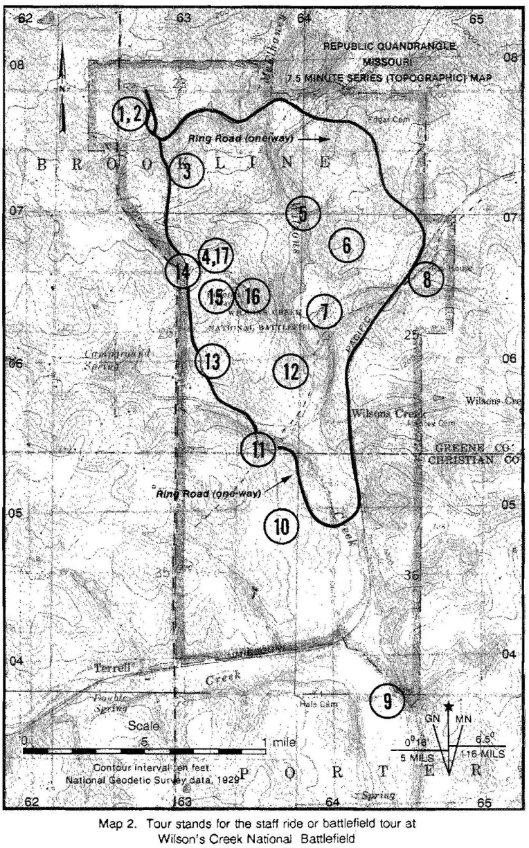
Situation: The Wilson’s Creek Visitor’s Center is a logical place to begin a staff ride or battlefield tour because a clear, concise overview of the campaign and battle can be obtained there. A short slide program at the center provides a good campaign overview, and a good terrain model demonstrates the battle with colored lights and audio narration. Unlike most presentations of this kind, this one is quite effective and helps clarify tactical movements and the battle’s flow. Preferably, this presentation should be experienced before and after walking the battlefield. (For a sequence of the stands and their grids, see table 2; for a map of the Wilson’s Creek National Battlefield and the location of the various staff ride stands, see map 2.) In addition, the park historian may be available for a short demonstration of Civil War artillery and infantry tactics.
Teaching Points: The Union plan and principles of the objective, offensive, and surprise.
Vignettes: General Lyon wrote this message to General Frémont on 27 July 1861 from Springfield:
Memorandum for Col. Phelps (the bearer). See General Frémont about troops and stores for this place. Our men have not been paid and are rather dispirited; they are badly off for clothing and the want of shoes unfits them for marching. Some staff officers are badly needed, and the interests of the government suffer for the want of them. The time of the three months volunteers is nearly out, and on their returning home my command will be reduced too low for effective operations. Troops must at once be forwarded to supply their place. The safety of the State is hazarded. Orders from Gen. Scott strip the entire West of regular forces and increase the chances of sacrificing it. The public press is full of reports that troops from other States are moving toward the northern border of Arkansas for the purpose of invading Missouri. Springfield, July 27. (Adams and Return Ira Holcombe, An Account of the Battle of Wilson’s Creek [Springfield, MO: The Springfield Public Library and Greene County Historical Society, 1961], 18.)
General Lyon, in his last message to General Frémont on 9 August 1861 (the day before the battle), reports:
I retired to this place [Springfield] ...reaching here on the 5th [of August 1861]. The enemy followed to within 10 miles of here. He has taken a strong position, and is recruiting his supplies of horses, mules, and provisions by foraging into the surrounding country, his large force of mounted men enabling him to do this without much annoyance from me. I find my position extremely embarrassing, and am at present unable to determine whether I shall be able to maintain my ground or be forced to retire. I can resist any attack from the front, but if the enemy move to surround me, I must retire. I shall hold my ground as long as possible, though I may endanger the safety of my entire force....The enemy yesterday made a show of force about five miles distant, and has doubtless a full purpose of making an attack upon me.
(The War of the Rebellion: A Compilation of the Official Records of the Union and Confederate Armies, ser. 1, vol. 3 [Washington, DC: U.S. Government Printing Office, 1881; reprint, Wilmington, NC; Broadfoot Publishing Co., 1985], 57. Hereafter referred to as O.R.)
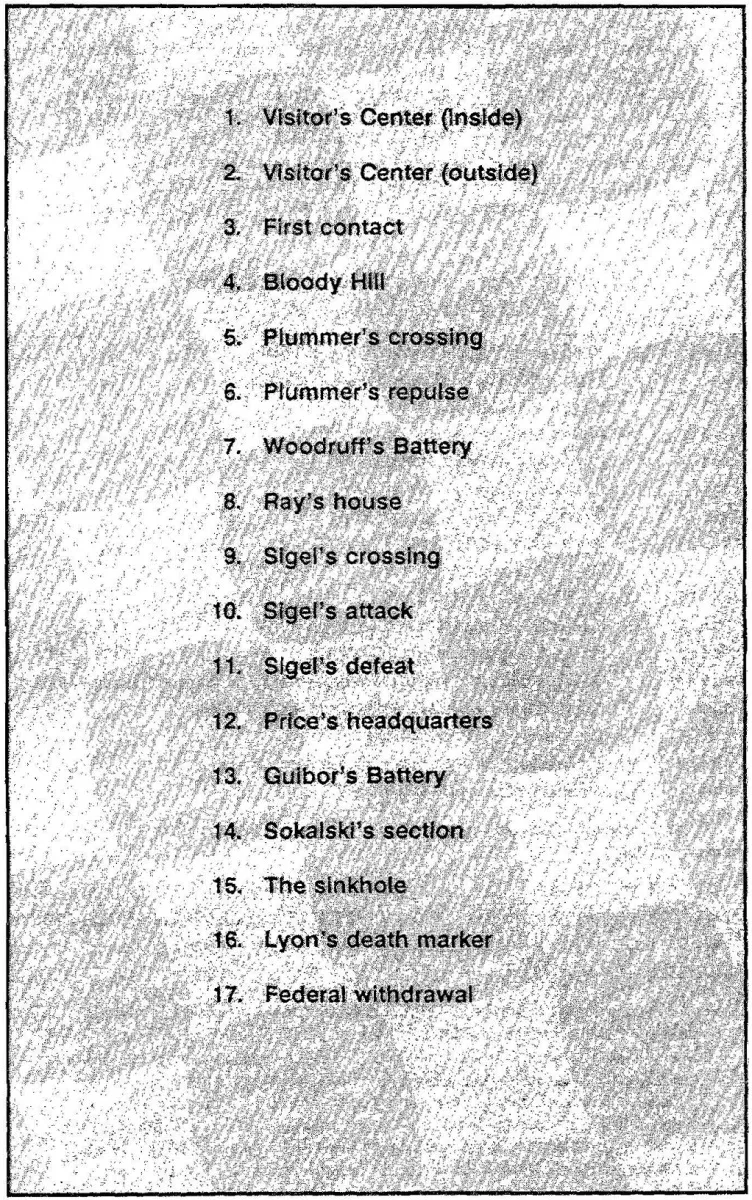
Table 2. Stands and Grid Numbers for the Staff Ride or Battlefield Tour*
Stand 1—The Visitor’s Center (inside), grid 627076.
Stand 2—The Visitor’s-Center (outside), grid 627076.
Stand 3—First contact, grid 631073.
Stand 4—Bloody Hill, grid 632066.
Stand 5—Plummer’s crossing, grid 637069.
Stand 6—Plummer’s repulse, grid 642066.
Stand 7—Woodruff’s Battery, grid 639063.
Stand 8—Ray’s house, grid 646066.
Stand 9—Sigel’s crossing, grid 644037.
Stand 10—Sigel’s attack, grid 635047.
Stand 11—Sigel’s defeat, grid 635054.
Stand 12—Price’s headquarters, grid 638058.
Stand 13—Guibor’s Battery (Confederate line extends to the west), grid 633059.
Stand 14—Sokalski’s section (Totten’s battery), grid 631066.
Stand 15—The sinkhole, grid 633065.
Stand 16—Lyon’s death marker, grid 635064.
Stand 17—Federal withdrawal, grid 632066.
*Suggested routes for movement between the stands are given at the end of each stand narrative.
What intent does this message convey to Frémont? Is it possible that this message was a ruse? Contrast Lyon’s message with the report of Major John M. Schofield, Lyon’s adjutant general, written 20 August 1861:
During the forenoon of [the 9th of August], General Lyon and Colonel Sigel held a consultation, the result of which was the plan of attack upon the enemy’s position at Wilson’s Creek....General Lyon informed me of his determination to make the attack the next morning and gave me the general features of the plan but owing to the press of time did not go into much detail. Colonel Sigel was to move with his brigade ... to the left [east] of the main Cassville Road leading to the right [south] of the enemy position, while General Lyon with the remainder of the force...was to move down the road toward Little York... and attack his left [north] flank. Colonel Sigel was to make his attack as soon as he heard that of General Lyon. (O.R., 60.)
Route to Stand 2: Stand 2 is at the picnic area just outside the Visitor’s Center. This is a good place to remind the group that there are no latrines or fresh water facilities on the field. Remind the group also of regulations governing removal of items found on the battlefield and of the seasonal danger of snakes, ticks, chiggers, poison oak, and cactus.
Stand 2 — (Visitor’s Center [outside], grid 627076)
Situation: General Lyon’s column left Springfield at about 1700 on 9 August and reached a point about one and one-half miles north of this stand at about 0100, 10 August. About twenty local residents served as his guides and rode with the Union column. Lyon expected to encounter Confederate pickets but did not do so because the Confederate commanders had recalled their pickets in preparation for their own planned advance. When the Confederate advance was canceled because of light rain about 2100 on 9 August, they had failed to repost their pickets. Therefore, the Confederate camps were unprotected by outpost pickets as Lyon approached them and mounted his attack. (For a map of the battlefield area in 1861, see map 3.)
When the Union column halted at about 0100, the men laid down on their arms. Meanwhile, Lyon sent the cavalry forward to determine the Confederate positions. At dawn, the Union march resumed, with Captain Plummer’s battalion of Regular infantry leading, followed by Major Peter J. Osterhaus’ battalion of Missouri Volunteers and Captain Totten’s battery of six guns.
Teaching Points: Navigation to this point, use of local guides, organization for combat, order of march, intelligence, principles of security, and surprise.
Vignette: On 9 August, it was hot, but it became cooler when the sun set. Private Eugene F. Ware of the 1st Iowa describes the march:
. . . life became more endurable and the marching was anything but a funeral procession. The boys gave each other elaborate instructions as to the materials out of which they wanted their coffins made, and how they wanted them decorated.... We moved short distances from 20 to 100 yards at a time, and kept halting and closing up, and making very slow progress , ... There were some little light clouds, but it was light enough to see a short distance around us, by starlight.... Finally, word was passed along the line that we were inside the enemy’s picket line but were two or three miles from their camp. Rumors magnified the number of the foe to 25,000. We could see the sheen in the sky of vast campfires beyond the hills.... We also heard, at times, the choruses of braying mules .... About this time [0100].. . the line stopped at a place where our company stood on a broad ledge of rock. We all laid down on this rock to get rested. The cool dewy night air made me feel chilly...but the radiating heat which the rock...had absorbed, was peculiarly comfortable.
(Eugene F. Ware, The Lyon Campaign in Missouri [Topeka, KS: Crane & Co., 1907], 310–13.)
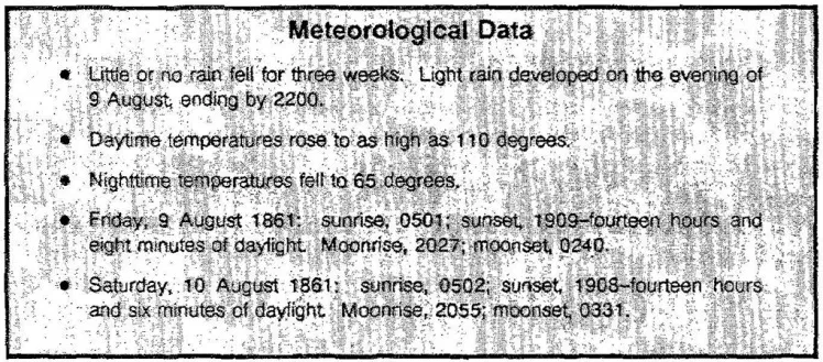
Meteorological data from the Farmer’s Almanac, 1861, indicates the following:
August 9, 1861. Sunrise 5:01 AM, sunset 7:09 PM, 14 hours and 8 minutes of daylight. Moonrise 10:27 PM, moonset 2:40 AM.
August 10, 1861. Sunrise 5:02 AM, sunset 7:08 PM, 14 hours and 6 minutes of daylight. Moonrise 10:55 PM, moonset 3:31 AM.
Full moon on August 20, new moon on August 6th, 1st quarter on August 13th, last quarter on August 28th.
Route to Stand 3: If moving by foot, leave the Visitor’s Center picnic area and follow the western Ring Road to the National Park Service’s stop number 8, historic overlook. Follow the gravel path eastward for about 125 meters until you come out into the open. From this vantage point, you can take several bearings. The Ray house is almost due east at a range of 1,750 meters. Far to the northeast, you can see the red and white chimneys of a power plant. Bloody Hill is almost due south about 700 meters. From this position, move cross-country to the northeast about seventy meters to the vicinity of grid 631073.
If moving by vehicles, go completely around Ring Road and park at National Park Service stop number 8, historic overlook; then, follow the instructions above. You are now standing in the field where Confederate Colonel B. A. Rives cavalry first encountered General Lyon’s column. Lyon deployed along the wood line to your north.
Stand 3 — (First contact, grid 631073)
Situation: The Union advance took the Confederates by surprise. At dawn on 10 August 1861, a patrol from Colonel Cawthorn’s mounted brigade (attached to General Rains’ division of Missouri State Guards) worked the west bank of Wilson’s Creek and discovered Federals in the area (see map 4). Another force of about 300 mounted Missouri Confederates under Colonel Rives moved northward to this point and discovered Lyon’s main force. Confronted by this large force, the Missourians fell back to the north face of Bloody Hill where Colonel Cawthorn established a line of about 600 dismounted men.
Lyon now deployed with Plummer on the left (east), Major Osterhaus on the right (west), and Lieutenant Colonel George L. Andrews (the 1st Missouri) in the center. Totten unlimbered one section (two guns) under First Lieutenant George O. Sokalski and began firing. After driving off the 300 mounted Confederates from this area, Lyon continued his advance to the south and discovered Cawthorn’s dismounted brigade in the low ground just north of Bloody Hill. Lyon then deployed the 1st Kansas (under Colonel George W. Deitzler) to the left (east) of the 1st Missouri. The Union line advanced so rapidly, however, that Totten could not get the remainder of his force organized into a supporting battery. A brief skirmish followed, and the Confederates withdrew in disarray, leaving Lyon in control of Bloody Hill. Lyon now brought the remainder of his force forward to the shelter of the north slope.
Teaching Points: Security, surprise, and the experience of real battle. Compare the reactions of Lyon’s and Cawthorn’s troops. What was the effect of Sokalski’s section? Discuss deployment from the line of march.
Vignettes: In his official report, Andrews of the 1st Missouri claims that his unit had the honor of firing the first shot of the battle:
Soon after the column was again in motion, I received an order to bring the regiment forward ... I received orders to deploy one company forward as skirmishers, and this was the last order that reached me during the entire day. Company H, Captain Yates, was at once thrown out as skirmishers, closely followed by the regiment in column of companies, and advancing up the hill, the action was commenced by a shot from...
![Wilson's Creek Staff Ride And Battlefield Tour [Illustrated Edition]](https://img.perlego.com/book-covers/3018869/9781782895268_300_450.webp)