Mineral Deposits, Exploration and Ore-Reserve Estimation (Volume 3)
Ifan Odwyn Jones, Mehrooz Aspandiar, Allison Dugdale, Neal Leggo, Ian Glacken, Bryan Smith
This is a test
This is a test
180 páginas
English
ePUB (apto para móviles)
Disponible en iOS y Android
eBook - ePub
The Business of Mining
Mineral Deposits, Exploration and Ore-Reserve Estimation (Volume 3)
Ifan Odwyn Jones, Mehrooz Aspandiar, Allison Dugdale, Neal Leggo, Ian Glacken, Bryan Smith
Detalles del libro
Vista previa del libro
Índice
Citas
Información del libro
The Business of Mining complete set of three Focus books provides readers with a holistic all-embracing appraisal of the analytical tools available for assessing the economic viability of prospective mines. Each volume has a discrete focus. This third volume commences with "Our Earth, its Minerals and Ore Bodies", followed by a review of mineral exploration and sampling of mineral deposits. It continues with detailed sections covering the reporting of mineral resources and reserves in Australia, and concludes with the basic principles and application of the various methods of estimating the in-situ mineral resources and ore reserves.
The books were written primarily for undergraduate applied geologists, mining engineers and extractive metallurgists and those pursuing course-based postgraduate programs in mineral economics. However, the complete series will also be an extremely useful reference text for practicing mining professionals as well as for consultant geologists, mining engineers or primary metallurgists.
Preguntas frecuentes
¿Cómo cancelo mi suscripción?
Simplemente, dirígete a la sección ajustes de la cuenta y haz clic en «Cancelar suscripción». Así de sencillo. Después de cancelar tu suscripción, esta permanecerá activa el tiempo restante que hayas pagado. Obtén más información aquí.
¿Cómo descargo los libros?
Por el momento, todos nuestros libros ePub adaptables a dispositivos móviles se pueden descargar a través de la aplicación. La mayor parte de nuestros PDF también se puede descargar y ya estamos trabajando para que el resto también sea descargable. Obtén más información aquí.
¿En qué se diferencian los planes de precios?
Ambos planes te permiten acceder por completo a la biblioteca y a todas las funciones de Perlego. Las únicas diferencias son el precio y el período de suscripción: con el plan anual ahorrarás en torno a un 30 % en comparación con 12 meses de un plan mensual.
¿Qué es Perlego?
Somos un servicio de suscripción de libros de texto en línea que te permite acceder a toda una biblioteca en línea por menos de lo que cuesta un libro al mes. Con más de un millón de libros sobre más de 1000 categorías, ¡tenemos todo lo que necesitas! Obtén más información aquí.
¿Perlego ofrece la función de texto a voz?
Busca el símbolo de lectura en voz alta en tu próximo libro para ver si puedes escucharlo. La herramienta de lectura en voz alta lee el texto en voz alta por ti, resaltando el texto a medida que se lee. Puedes pausarla, acelerarla y ralentizarla. Obtén más información aquí.
¿Es The Business of Mining un PDF/ePUB en línea?
Sí, puedes acceder a The Business of Mining de Ifan Odwyn Jones, Mehrooz Aspandiar, Allison Dugdale, Neal Leggo, Ian Glacken, Bryan Smith en formato PDF o ePUB, así como a otros libros populares de Betriebswirtschaft y Industrielle Gewinnung natürlicher Ressourcen. Tenemos más de un millón de libros disponibles en nuestro catálogo para que explores.
Our planet Earth was created 4.55 billion years ago from condensates in a cosmic gas cloud that was the resultant product of a supernova. All the material goods that are essential in our daily lives are provided for us by our Earth, which approximates a closed system with regards to matter. However, as our planet moves through space it is continuously bombarded by meteorites and several tons of cosmic dust each day. Hence, the Earth is gradually increasing in size by ongoing planetary accretion. Only energy is exchanged with space. Energy from space is sourced from the sun whilst at the same time energy is radiated from the Earth. Overall this exchange is balanced to enable the Earth to keep an overall stable temperature.
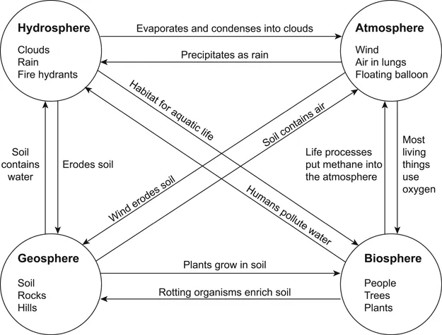
The Earth contains four key spheres the atmosphere, hydrosphere, biosphere and the geosphere (Figure 1.1). Mineral and petroleum resources that are vital to our everyday life are extracted from the geosphere. However, many of these resources developed as a result of the dynamic interactions between these spheres.
The composition of the Earth
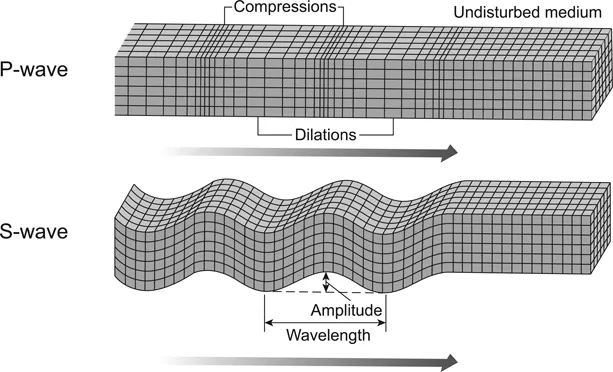
From our perspective as humans living on the surface, the Earth appears to be static except for the occasional earthquake or volcanic eruption but in truth it is dynamic. The study of earthquakes (seismology) led to the understanding of the formation and propagation of elastic (seismic) waves within the earth. An earthquake produces three types of seismic waves: Primary (P-), Secondary (S-) and surface (Rayleigh) waves. The P- and S-waves are referred to as body waves. P-waves travel in a similar fashion to ordinary sound waves, which propagate in the same direction as that of the wave, and are the fastest of the three waves (Figure 1.2). In contrast, S-waves move at right angles to the direction of wave propagation and travel at about half the speed of P-waves (Figure xx). P-waves can travel through both solid and liquid, whereas S-waves can only travel through solid material. The study of P- and S-waves generated by earthquakes has provided us with an understanding of the internal structure of the Earth.
Figure 1.1 Illustration of the four Earth spheres: hydrosphere; atmosphere; biosphere and geosphere; and the dynamic interactions between the spheres.
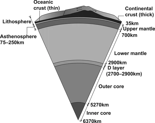
Basically the Earth comprises three main concentric shells: crust, mantle and core (Figure 1.3). The crust is the rigid outer layer of the Earth and it comprises two distinct types: oceanic and continental. Oceanic crust is predominately composed of mafic igneous rocks (basalt and gabbro) and has an average density of 3.0 g/cm3 and an average thickness of 7 km. Continental crust has a variable composition but has an average density of 2.7 g/cm3 and a variable thickness, the average of which is 40 km but can be more than 70 km. The contact between the crust and the mantle is known as the Mohorovicic discontinuity (also known as the Moho) which was defined in 1909 by Croatian seismologist Andrija Mohorovicic. The Moho marks a change increase in the velocity of both P- and S-waves.
Figure 1.2 Seismic wave propagation of P- and S-waves.
Source: Smithsonian Ocean Portal.
Figure 1.3 Illustration showing a simplified layered interior of the Earth.
Source: Ace Geography.
The mantle comprises 82% of the earth’s volume and we know from the continuity of S-waves through the mantle that it is solid, although due to the high temperatures the rocks can flow at very slow velocities. The mantle itself is also subdivided into two sublayers: upper mantle and lower mantle (Figure 1.3). The chemical composition of the upper mantle is revealed by rock fragments brought to the surface by deep-seated magmas. These indicate that the upper mantle is primarily composed of peridotite (an ultramafic rock consisting mainly of the mineral olivine). At approximately 660 km depth both S- and P-waves show a significant increase in velocity; this marks the boundary to the lower mantle, which is the single largest layer occupying 52% volume of our planet. At depths of ~ 2700 km the S-wave velocities decrease by 30% indicating a weakness in the material. This zone is known as D” layer and it is interpreted to be a zone with significant variations in composition as well as temperature, it also marks the boundary between the rocky mantle and the core (Figure 1.3). The speed of seismic waves through the mantle, calculated from travel times, indicates an overall increase in rock density from 3.3 g/cm3 in the upper mantle to 5.5g/cm3 at the base.
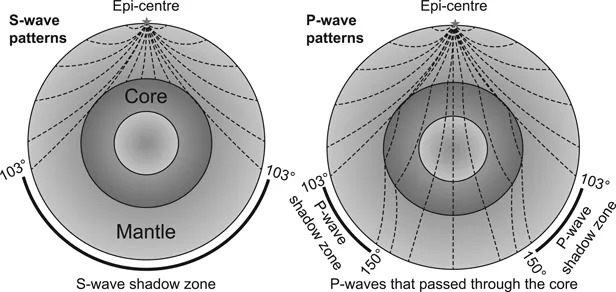
Figure 1.4 Seismic wave propagation through the Earth’s mantle and core, showing development of S- and P-wave shadow zones.
Source: Physical Geology by Steven Earle is used under a CC BY 4.0 Licence, https://opentextbc.ca/geology/
The presence of a core within the Earth was first detected by geologist Richard Dixon Oldham in 1905. Through the study of P- and S-waves emitted from a large earthquake, Oldham observed that at locations 100º from the epicenter the transmission of P- and S-waves was very weak to absent respectively (Oldham, 1905). This was evidence that a central core existed that created a shadow zone for seismic waves (Figure 1.4). The absences of S-waves indicated that the outer core is liquid and the refraction of P-waves confirmed the presence of a solid inner core. It is generally accepted that both the inner and outer core are metallic, based largely on our knowledge of meteorites. The metal phase of meteorites contains approximately 94% iron and 6% nickel. It is, therefore, assumed that iron is the major component of the earth’s core, with a small amount of nickel and another low atomic weight element such as sulphur, silicon, oxygen or carbon.
Plate tectonics
In the early part of the 19th century, meteorologist/geophysicist Albert Wegener introduced the hypothesis of continental drift (Wegener, 1912). He proposed that a single supercontinent (named Pangea) once existed but subsequently fragmented into continental blocks which drifted apart to their current position. Evidence in the form of fossils, matching coastlines, continuity of rock types and climate zones all indicated that Pangea had existed. However, there was no viable mechanism proposed to explain how the continents drifted apart after the fragmentation of Pangea. This was hotly debated until the 1960s when extensive oceanographic surveys recorded the presence of earthquakes localised beneath deep-ocean trenches and sampling of the oceanic crust found that there was no oceanic crust older than 180 million years. These discoveries lead to the formulation of the theory of plate tectonics.
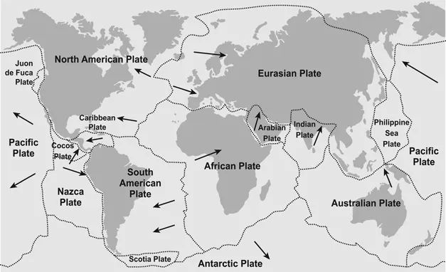
Figure 1.5 Map of the Earth showing the seven major tectonic plates and the current movement direction of the plates.
The fundamental basis for the theory of plate tectonics is the recognition that the outer layers of the Earth are made up of seven major and numerous minor moving plates (Figure 1.5). Each plate comprises a crustal component and the upper part of the upper mantle, known as the lithospheric mantle. This combination forms a rigid outer zone called the lithosphere and hence the lithospheric plates. The thickness of the lithosphere in areas dominated by oceanic crust is approximately 100 km compared to 200 km in areas dominated by continental crust. The layer of the upper mantle beneath the lithospheric mantle is known as the asthenosphere, which is weaker (plastic) and denser compared to the lithosphere. Hence the lithospheric plates essentially float on top of the asthenosphere and these changes enable the plates to move independently from the asthenosphere.
The main driving force for the movement of the lithospheric plates comes from the Earth’s internal heat energy, which is primarily driven by radioactive decay of elements such as uranium and residual heat from the formation of the planet 4.55 billion years ago. Within the mantle, heat is transferred by convection in which hot rocks rise upwards but as they cool they begin to sink leading to the formation of convection cells. In areas where the litho-sphere is extended or thinned, the asthenosphere will be closer to the earth’s surface which can focus the upwelling hot rocks which leads to the melting of the asthenosphere below the lithosphere boundary and the intrusion of hot primary mantle derived magma. The volume of the intruded magma forces the lithospheric plates to push apart and separate. The episodic nature of ocean basin opening and closing was first noted by John T Wilson in the early 1960s and is known as the Wilson Cycle (Wilson, 1963). Recent, seismic tomography maps of the Earth’s interior show zones of fast and slow seismic S-wave velocity (Wookey and Dobson, 2008). Data collected from depths of ~ 2770 km in the lowermost part of the lower mantle shows two major areas of low S-wave velocity which are interpreted to represent gigantic mantle plumes named Great African and Central Pacific super plumes. It is suggested that the presence and magmatism associated of these super plumes may initiate lithospheric plate movement.
Mountains and oceans
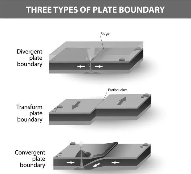
The interactions at the boundaries between lithospheric plates has created the ever-changing landscape of our Earth through the formation of oceans, mountains and volcanoes. The thought that the ground on which we are standing is moving is difficult to comprehend but global positioning system (GPS) technology shows that the lithospheric plates are in constant motion (Figure 1.5). There are three types of boundaries between lithospheric plates (Figure 1.6): 1. Divergent, where the plates are separating with the development of new crust; 2. Convergent, where the plates are colliding, which results in the destruction of older crust; and 3. Transform, where the plates slide past one another along a major fault line. All of these boundaries are associated with increased seismic activity in the form of earthquakes.
Figure 1.6 The different types of plate tectonic boundaries: a) Divergent, b) Transform and c) Convergent, with or without subduction.
Detailed oceanography of the deeper abyssal portions of the ...