eBook - ePub
Historical Atlas of Indonesia
Robert Cribb
This is a test
- 240 páginas
- English
- ePUB (apto para móviles)
- Disponible en iOS y Android
eBook - ePub
Historical Atlas of Indonesia
Robert Cribb
Detalles del libro
Vista previa del libro
Índice
Citas
Información del libro
This pioneering volume traces the history of the region which became Indonesia, from early times to the present day, in over three hundred specially drawn full-colour maps with detailed accompanying text. In doing so, the Atlas brings fresh life to the fascinating and tangled history of this immense archipelago. Beginning with the geographical and
Preguntas frecuentes
¿Cómo cancelo mi suscripción?
¿Cómo descargo los libros?
Por el momento, todos nuestros libros ePub adaptables a dispositivos móviles se pueden descargar a través de la aplicación. La mayor parte de nuestros PDF también se puede descargar y ya estamos trabajando para que el resto también sea descargable. Obtén más información aquí.
¿En qué se diferencian los planes de precios?
Ambos planes te permiten acceder por completo a la biblioteca y a todas las funciones de Perlego. Las únicas diferencias son el precio y el período de suscripción: con el plan anual ahorrarás en torno a un 30 % en comparación con 12 meses de un plan mensual.
¿Qué es Perlego?
Somos un servicio de suscripción de libros de texto en línea que te permite acceder a toda una biblioteca en línea por menos de lo que cuesta un libro al mes. Con más de un millón de libros sobre más de 1000 categorías, ¡tenemos todo lo que necesitas! Obtén más información aquí.
¿Perlego ofrece la función de texto a voz?
Busca el símbolo de lectura en voz alta en tu próximo libro para ver si puedes escucharlo. La herramienta de lectura en voz alta lee el texto en voz alta por ti, resaltando el texto a medida que se lee. Puedes pausarla, acelerarla y ralentizarla. Obtén más información aquí.
¿Es Historical Atlas of Indonesia un PDF/ePUB en línea?
Sí, puedes acceder a Historical Atlas of Indonesia de Robert Cribb en formato PDF o ePUB, así como a otros libros populares de Social Sciences y Ethnic Studies. Tenemos más de un millón de libros disponibles en nuestro catálogo para que explores.
Información
Chapter 1
Landscape and Environment
The Indonesian islands and their varied landscapes are the creation of tumultuous geological forces and far-reaching human intervention. The broad outlines of the archipelago’s geography were shaped over millions of years by the slow movement of continental plates across the Earth, and new details are continually etched into the surface of the region by volcanic eruptions and earthquakes and by the slower processes of erosion and sedimentation. Human beings, however, have further transformed the landscape, removing forest cover, carving rice terraces into volcanic slopes, introducing new species of animals and plants, and harvesting or hunting others, sometimes to the point of extinction. The earliest human impact on the environment can be traced to about nine thousand years ago, but the pace of ecological change has increased dramatically in the last hundred years. Destruction of the environment by deforestation, pollution and over fishing loom as the most serious issues facing Indonesia in the twenty-first century. Knowing how the environment has changed in the past, however, is important in understanding the likely impact of recent changes, and this chapter explores the many ways in which the face of the Indonesian archipelago has been transformed in time.
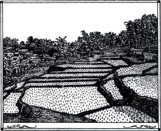
1.i Ricefields (saivah), bananas and coconuts. Many features of the Javanese landscape were a product of far-reaching human intervention into the environment.
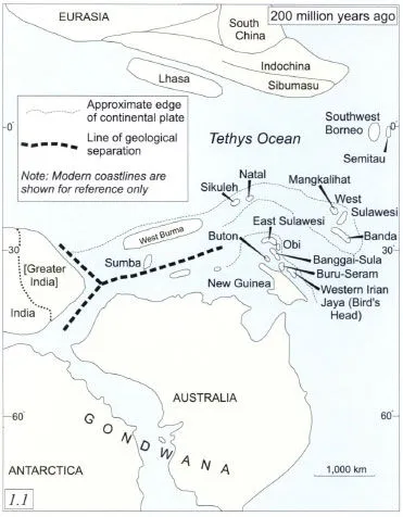
1.1 Continental plates and plate fragments, 200 million years ago.
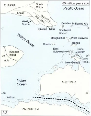
1.2 Continental plates and plate fragments, 65 million years ago.
Moving Continents and Fiery Mountains
Most of the world’s dry land is carried on continental plates, huge rafts of rock which have drifted slowly about the surface of the Earth for hundreds of millions of years. Three hundred and thirty million years ago, the continental plates carrying what is now Indonesia were part of an enormous southern continent now called Gondwana, which comprised the present Antarctic, Australian, Indian, African and South American plates, as well as numerous smaller fragments. Gondwana was separated from the northern continent, Laurasia, by the so-called Tethys Ocean. Each continent carried its own distinctive flora and fauna: Gondwana was home to marsupials and Araucaria pine trees, while Laurasia was the home of tigers, monkeys and cattle, and of trees such as oaks and dipterocarps.
Approximately two hundred million years ago, fragments of Gondwana began to break off and drift north. One of the first of these fragments was a long sliver of continental plate which geologists now call ‘Sibumasu’, because today it coincides with the regions Siam (Thailand), Burma, Malaya and Sumatra. The West Burma plate, together with fragments which later attached themselves to Sumatra, Borneo and Sulawesi, separated from Gondwana about 135 million years ago. By the end of the Cretaceous period, 65 million years ago, India had broken away from Gondwana and a chain of plate fragments stretched between Australia and Asia.
Indonesia’s underlying geological shape continues to change, as the northward movement of the Australian and Indian plates compresses the southern and eastern rims of the archipelago, while the northeast is influenced by movement of the Pacific plate. Movement is slow – a few centimetres a century – but over long periods enough to transform the archipelago profoundly.
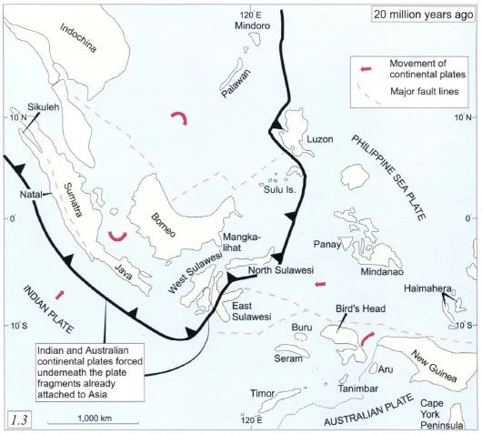
1.3 Continental plates and plate fragments, 20 million years ago.
The abundance of junctions between continental plates and plate fragments makes Indonesia a region of great geological instability. Earth tremors are common, and major earthquakes have caused great destruction on many occasions. The historical record of earthquakes before the twentieth century is extremely patchy. Only in a few cases can the scale of the destruction or the number of casualties be given with any certainty.
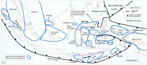
1.4 The tectonic structure of the Indonesian archipelago, showing approximate boundaries of plates and plate fragments.
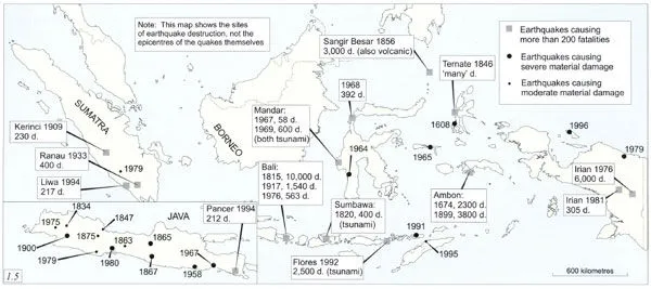
1.5 Major destructive earthquakes in Indonesian history. In many cases the worst destruction was caused not by earthquakes themselves but by associated tsunami (‘tidal waves’).
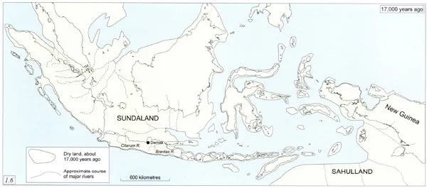
1.6 Coastlines of the archipelago, c. 17,000 years ago.
Although the underlying geological structure of the Indonesian archipelago was produced over many millions of years, the present outline of the islands of the archipelago is of relatively recent origin. Global sea levels have changed many times during the last million years as water has been locked up in icecaps during ice ages or released during periods of warmer climatic conditions. During the last ice age, which was at its peak about 17,000 years ago, sea levels were about 200 metres lower than today. The islands of western Indonesia then formed a sub-continental peninsula, sometimes called Sundaland, stretching southeast from the Asian mainland. In the same period, New Guinea and its adjacent islands formed a northern extension of Australia, sometimes called Sahulland. Archaeological and palaeo-logical evidence suggests that the region was considerably drier than it is now, and that the lowland plains were probably covered with savannah and sparse scrub.
A second cause of change in the physical outline of the Indonesian islands has been sedimentation. The young volcanic rocks of Java and Sumatra erode easily, and during the last two thousand years the northern coastlines of both islands have grown. Determining how much they have grown, however, is difficult. Early maps and descriptions are seldom precise or reliable enough to give definitive information, and ancient historians have had no more than fragmentary materials to work with. Some historians have speculated that most of the areas which are now lowland swamp in Sumatra were sea in fairly recent historical times, but recent archaeological investigation suggests that the coastline two thousand years ago was not greatly different from today.
More reliable evidence of coastal change comes from Java, where coastlines have advanced significantly since the arrival of the Dutch and the start of record-keeping on such matters. The deltas of the Citarum and Brantas rivers in West and East Java have grown considerably, while the former coastal city of Demak in Central Java is now nearly twenty kilometres inland.
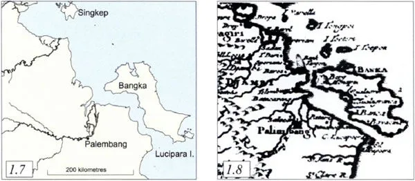
1.7–1.8 The Sumatra coastline near Bangka today (left) and according to an eighteenth-century map (right). Although many of the geographical details on the older map can be matched to points on a modem map, it is impossible to say whether the differences are a matter of changing geography or different degrees of accuracy.
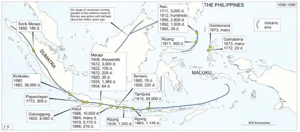
1.9 Major destructive volcanic eruptions in Indonesian history, 1006–1996.
Volcanic activity and earthquakes are the most striking consequence of the archipelago’s geological instability. Indonesia’s volcanoes stretch in an arc along the length of Sumatra and Java before fanning into a broad zone of instability in Maluku which continues on up into the Philippines.
The historical record of eruptions throughout the archipelago is fragmentary. Relatively complete records were kept only in the 19th and 20th centuries; for earlier eras, only the most destructive events were recorded. The best record of volcanic eruptions comes from Java, where court chronicles, combined with the correspondence and reports of Dutch colonial officials, allow a reasonably complete picture of volcanic activity since the late 17th century. In addition to Java’s 21 active volcanoes, there are ten major solfataras, or sulphur fields, many of them in the craters of volcanoes which are not presently considered active.
Java’s volcanic history shows how unpredictable volcanoes are in the long term: some have erupted persistently through recorded history, while others have made their presence felt only in brief, destructive paroxysms. The density of human settlement in Java, however, means that any major eruption in the future will be costly of property and, probably, life.
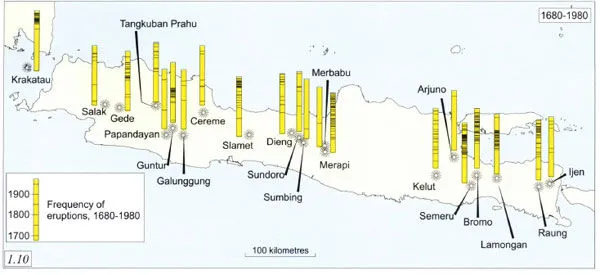
1.10 Volcanic eruptions in Java, 1680–1980.
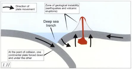
1.11 Schematic diagram of the collision between two continental plates.
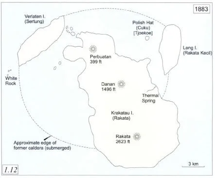
1.12 Krakatau before the 1883 eruption.
The most destructive volcanic eruption in Indonesia in recent times was that of Tambora on the island of Sumbawa in April 1815, when two small kingdoms were destroyed and perhaps 50,000 people were killed. Because few Europeans were in the immediate vicinity, not many records of the uprising have survived. In contrast, the 1883 eruption of Krakatau (sometimes called Krakatoa), although less explosive and less destructive tha...
Índice
- Cover
- Half Title
- Title Page
- Copyright
- Contents
- List of Maps
- List of Figures
- Acknowledgements
- Introduction
- 1. Landscape and Environment
- 2. Peoples
- 3. States and Polities until 1800
- 4. The Netherlands Indies, 1800–1942
- 5. War, Revolution and Political Transformation, 1942 to the Present
- Sources
- Select Bibliography
- Index
Estilos de citas para Historical Atlas of Indonesia
APA 6 Citation
Cribb, R. (2000). Historical Atlas of Indonesia (1st ed.). Taylor and Francis. Retrieved from https://www.perlego.com/book/1712691/historical-atlas-of-indonesia-pdf (Original work published 2000)
Chicago Citation
Cribb, Robert. (2000) 2000. Historical Atlas of Indonesia. 1st ed. Taylor and Francis. https://www.perlego.com/book/1712691/historical-atlas-of-indonesia-pdf.
Harvard Citation
Cribb, R. (2000) Historical Atlas of Indonesia. 1st edn. Taylor and Francis. Available at: https://www.perlego.com/book/1712691/historical-atlas-of-indonesia-pdf (Accessed: 14 October 2022).
MLA 7 Citation
Cribb, Robert. Historical Atlas of Indonesia. 1st ed. Taylor and Francis, 2000. Web. 14 Oct. 2022.