Mapping Tokyo in Fiction and Film explores ways that late 20 th - and early 21 st - century fiction and film from Japan literally and figuratively map Tokyo. The four dozen novels, stories, and films discussed here describe, define, and reflect on Tokyo urban space. They are part of the flow of Japanese-language texts being translated (or, in the case of film, subtitled) into English. Circulation in professionally translated and subtitled English-language versions helps ensure accessibility to the primarily anglophone readers of this study—and helps validate inclusion in lists of world literature and film. Tokyo's well-established culture of mapping signifies much more than a profound attachment to place or an affinity for maps as artifacts. It is, importantly, a counter-response to feelings of insecurity and disconnection—insofar as the mapping process helps impart a sense of predictability, stability, and placeness in the realand imagined city.
Preguntas frecuentes
¿Cómo cancelo mi suscripción?
Simplemente, dirígete a la sección ajustes de la cuenta y haz clic en «Cancelar suscripción». Así de sencillo. Después de cancelar tu suscripción, esta permanecerá activa el tiempo restante que hayas pagado. Obtén más información aquí.
¿Cómo descargo los libros?
Por el momento, todos nuestros libros ePub adaptables a dispositivos móviles se pueden descargar a través de la aplicación. La mayor parte de nuestros PDF también se puede descargar y ya estamos trabajando para que el resto también sea descargable. Obtén más información aquí.
¿En qué se diferencian los planes de precios?
Ambos planes te permiten acceder por completo a la biblioteca y a todas las funciones de Perlego. Las únicas diferencias son el precio y el período de suscripción: con el plan anual ahorrarás en torno a un 30 % en comparación con 12 meses de un plan mensual.
¿Qué es Perlego?
Somos un servicio de suscripción de libros de texto en línea que te permite acceder a toda una biblioteca en línea por menos de lo que cuesta un libro al mes. Con más de un millón de libros sobre más de 1000 categorías, ¡tenemos todo lo que necesitas! Obtén más información aquí.
¿Perlego ofrece la función de texto a voz?
Busca el símbolo de lectura en voz alta en tu próximo libro para ver si puedes escucharlo. La herramienta de lectura en voz alta lee el texto en voz alta por ti, resaltando el texto a medida que se lee. Puedes pausarla, acelerarla y ralentizarla. Obtén más información aquí.
¿Es Mapping Tokyo in Fiction and Film un PDF/ePUB en línea?
Sí, puedes acceder a Mapping Tokyo in Fiction and Film de Barbara E. Thornbury en formato PDF o ePUB, así como a otros libros populares de Letteratura y Critica letteraria di letteratura comparata. Tenemos más de un millón de libros disponibles en nuestro catálogo para que explores.
B. E. ThornburyMapping Tokyo in Fiction and Film Geocriticism and Spatial Literary Studieshttps://doi.org/10.1007/978-3-030-34276-0_1
Begin Abstract
1. Introduction
Barbara E. Thornbury1
(1)
Temple University, Philadelphia, PA, USA
Barbara E. Thornbury
End Abstract
“I had bought maps first thing” (2002 [1996], 244), the narrator of Mayumi Inaba’s short story “Morning Comes Twice a Day” (2002, “Asa ga nido kuru” 1996) tells readers at the outset. “A booklet of maps of metropolitan Tokyo arranged by ward. I didn’t know where I should go, so I unhurriedly leafed through the maps page by page. … [T]he names of districts I had never heard of, the amenities, hospitals, the libraries in each ward, the names of the art museums assailed my eyes. The labyrinthine roads ran on from top to bottom, meshes in a net” (ibid.).1 The narrator, a young, self-reliant woman employed at a publishing house, turns to maps as she seeks housing with reasonable rent for a person accompanied by a pet. Rejected because of her cat by landlords holding the keys to desirable dwellings, she ends up stretching her budget and buying an apartment in a high-rise building near Shinagawa Station in south-central Tokyo. “The owner of a condominium, no matter how small the unit, seemed to enjoy an extraterritoriality that others could not violate” (ibid., 247), she comes to realize as she finally acquires a place of her own on the city map.
This book is about the many ways that late twentieth- and early twenty-first-century fiction and film from Japan literally and figuratively map Tokyo. “Analysis of the formations and functions of the illusory power of representation is one of the ways in which scholars from literary, film and cultural studies can contribute to the new understandings of space and spatiality,” Maria Balshaw and Liam Kennedy write in their introduction to Urban Space and Representation (2000, 4). The novels, stories, and films that I discuss are part of the flow of Japanese-language texts being translated into English (or, in the case of film, subtitled in English) and circulated outside of Japan. They are works that describe, define, and reflect on Tokyo urban space—and, in so doing, convey compelling images of and perspectives on life there. The material originally won recognition in Japan from book and magazine publishers, film distributors, and, above all, readers and audiences. Much of it also garnered the acclaim of critics and prize-granting entities.2 Its circulation in professionally translated and subtitled English-language versions helps validate its inclusion in lists of world literature and world film3—and helps ensure its accessibility to the primarily anglophone readers of this study.
In analyzing representations of space and place (real, imagined, and real-and-imagined, to borrow the phrasing of Edward Soja [1996]) in fiction and film, I align Mapping Tokyo with the well-established and dynamic field of spatial literary and film studies. The temporal has ceded its former dominance. As Robert T. Tally Jr. notes, “slowly, and picking up pace especially after the Second World War, space began to reassert itself in critical theory, rivalling if not overtaking time in the significance it was accorded by critics and theorists” (2013, 3).4 When it comes to cities in particular, what scholars call the “spatial turn” in the humanities offers “renewed insights into our knowledge of the development of urban modernity and modern subjectivity” (Hallam 2010, 278). Literature and film are recognized as significant components of what James Donald refers to as “the interaction of inextricably entwined realities” that determine how cities are experienced and understood (2000, 47).5
I follow Tally’s lead in regarding mapping as “the most significant figure” in spatial literary and film studies—as he says, “partly because of its direct applicability to the current crisis of representation often cited by theorists of globalization or postmodernity, but also because of the ancient and well-known connections between cartographic and narrative discourse. To draw a map is to tell a story, in many ways, and vice versa” (2013, 4). There are scholars who take the position that the study of space in fiction and film may best be left to practitioners of geographic information system (GIS) technologies—experts in the production of digitally based interactive maps.6 However, in the humanities (where my project resides), mapping, as Sébastien Caquard succinctly puts it, “refers to a broader range of concepts and practices” than the scientific cartographer’s “specific set of conventions and techniques” (2011, 224). My project takes advantage of what David Cooper and Gary Priestnall call “the helpful malleability of the mapping metaphor” (2011, 250).7 Although I use mapping as a general term denoting a multifaceted mode of literary and cinematic analysis that gives precedence to space and place, I set the stage below by emphasizing that mapping also applies to ways in which Tokyo fiction and film function cartographically in a literal sense.
Tokyo’s Culture of Mapping
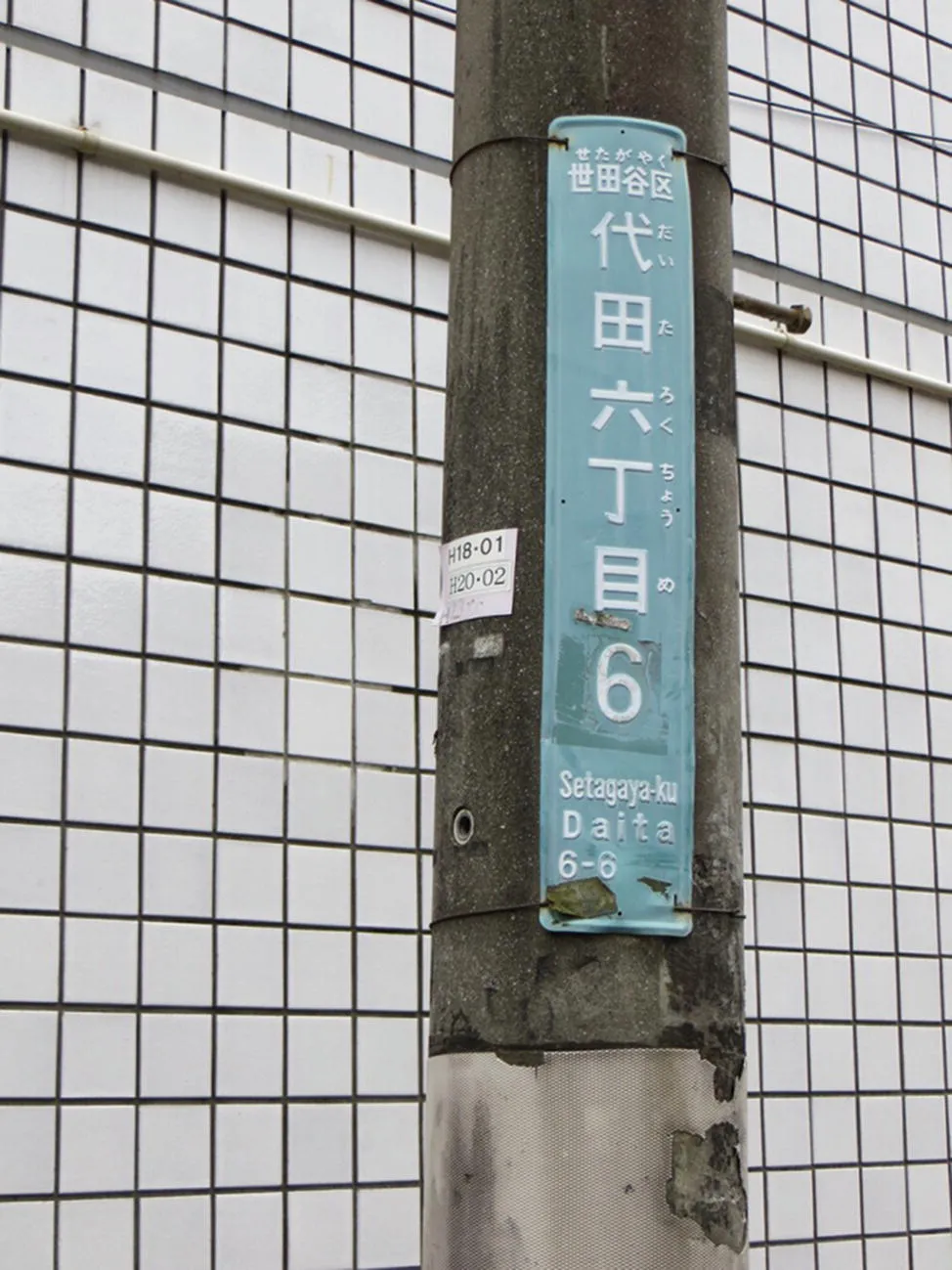
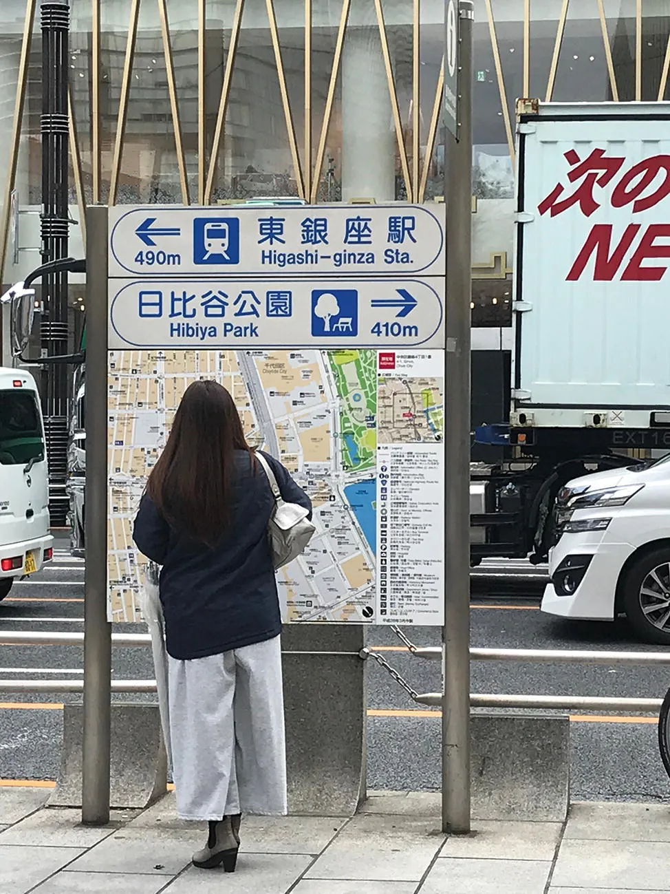
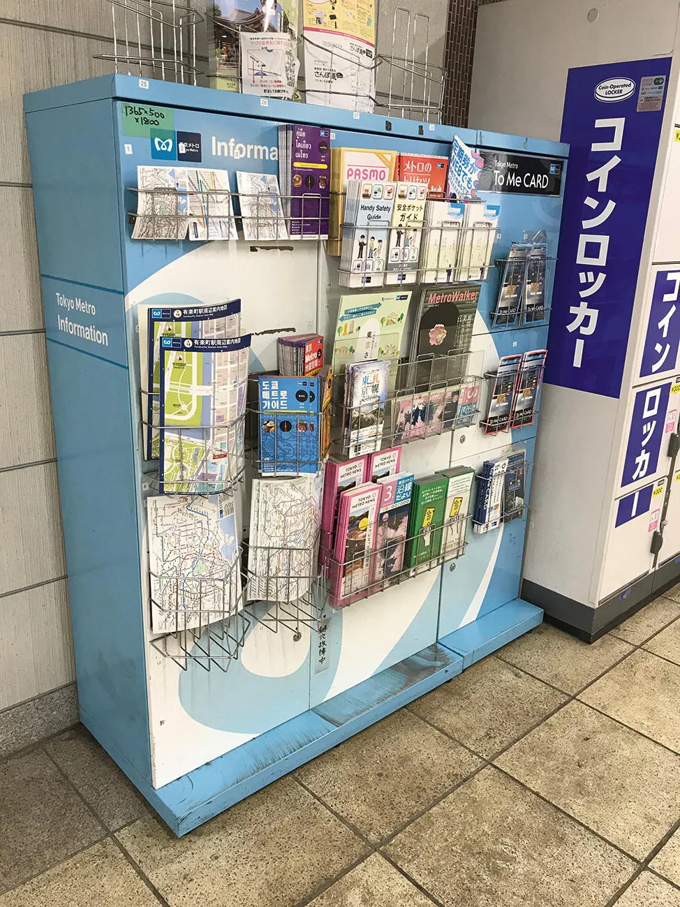
The conceptual starting point of this study is what I call Tokyo’s culture of mapping: the widespread and shared practices of mapmaking and map reading across all domains of life in that city. There is abundant evidence of such practices, first of all, in the street-level physical environment. Even if it cannot be statistically proven to surpass other conurbations in this respect, Tokyo is notably a city of maps. In such a massive and massively complex metropolis8—where streets do not necessarily have names and neighboring buildings may not be numbered consecutively—address plates are attached to utility poles, and map-boards are placed at frequent intervals along sidewalks to help guide pedestrians to their destinations.9 At neighborhood police substations, where uniformed officers can be counted on to give directions, a detailed map of the local precinct and its surrounding area is often posted near the front entrance. To guide customers and clients to shops, restaurants, and offices, maps are worked into the layout of business cards and advertisements.10 Marvels of graphic design, maps of Tokyo’s intricately connected train and subway lines are displayed on station walls, in train cars, and, of course, in digital form online.11 Freshly printed paper versions are free for the taking from racks in station concourses. Even in this era of GPS-enabled smartphones, newsstands and bookstore shelves are still stocked with up-to-date books of street and transit-system maps (Figs. 1.1, 1.2, 1.3, 1.4, and 1.5).12
Fig. 1.1
An address plate attached to a utility pole in Setagaya Ward
Fig. 1.2
Consulting a map-board on a Ginza sidewalk
Fig. 1.3
A map in front of a police substation at Ōtsuka railway station
Fig. 1.4
Consulting a map in Iidabashi Station
Fig. 1.5
Printed maps of various sizes free for the taking in a Tokyo subway station
Paul Waley has remarked on Tokyo’s “exceptionally rich topographical language” and its “deeply topophilic sensibility.” He cites as an example the array of names for the passenger ferry lines that once crisscrossed Tokyo’s principal waterway, the Sumida River, which runs through the eastern side of the city to Tokyo Bay. Each ferry-line name was “a repository” of cultural and historical associations (Waley 2003, 208 and 228).13 This “deeply topophilic sensibility” goes hand in hand with Tokyo’s culture of mapping—and, by extension, with what can be recognized as the city’s deeply cartographic sensibility.
That said, Tokyo’s culture of mapping signifies more than just a profound attachment to place or an affinity for maps as urban artifacts. A key point of this study is that Tokyo’s culture of mapping should also be viewed as a counter-response to the sense of insecurity and disconnection that pervades life in the real, imagined, and real-and-imagined city. In a book of essays on cinema and urban space, Stephen Barber pinpoints the twentieth-century historical underpinnings of this feeling of Tokyo unease: “Rendered in film, that city forms an unhinged and unliveable space … carry[ing] the historical residue of disparate but enduring variants of Tokyo that disappeared from the same site—the city flattened by the great earthquake of 1923, or that incinerated by the firestorms of 1945. Those virtual, destroyed cities inflect the contemporary one as phantom presences” (Barber 2002, 143). He cites the 1995 sarin gas attacks in the Tokyo subway system as an assault “[m]ore intimate to the present” that “infuse[s] the place with the potential for its population to be randomly decimated” (ibid., 144).
To extend Barber’s timeline to the present: the devastating March 2011 earthquake, tsunami, and subsequent nuclear meltdown in northeastern Japan literally shook the residents of Tokyo, leaving them with a persistent, low-grade “fever” of anxiety and fear. And, even putting aside the historical-scale cataclysmic events, there is a growing, generalized “sense of being out of place, out of sorts, disconnected,” as Anne Allison (2013, 14) writes in Precarious Japan. Street-level manifestations include the “string of violent attacks, all random and conspicuously public, [that have] plagued Tokyo” (ibid., 3) in recent years. Still seared into the public’s memory is the image of the twenty-five-year-old man who killed seven people in broad daylight in Akihabara, the busy commercial area packed with computer and videogame retailers.14 Copycat acts ensued—“[r]andom attacks on strangers by people desperately disconnected” (ibid.). Deployed in response, mapping helps impart a sense of predictability, stability, and placeness. With a map in hand, you can figure out where you are.
A map, as critical geographers such as J.B. Harley stress, may also be an instrument of control, a way for governments (the main mapmakers) and other powerful entities to demarcate space and dictate how it is to be understood and used (see, for example, Harley 1989). But, for the average individual going about his or her daily life, the political aspects of the mapmaking enterprise are not a direct concern: maps are “just” essential tools for secure and efficient navigation. The iconographic Tokyo transit system maps are primary ...
Índice
Cover
Front Matter
1. Introduction
2. Translation, Subtitling, and Tokyo Placemaking
3. Gender and Mobility: Tracking Fictional Characters on Real Monorails, Trains, Subways, and Trams
4. Coordinates of Home and Community
5. Locating the Outsider Inside Tokyo
6. Tokyo Cartographies of Mystery and Crime
7. Conclusion: Flux and Fluidity and World Literature and Film