![]()
CHAPTER 1
Ready to Rumble
What is most tragic is that the collective genius of all of these experts, combined with the sensors and satellite observations and seismographic data and all the other tools of science and technology, could not send the important message at the key moment: Run. Run for your lives.
—JOEL ACHENBACH, Washington Post, January 30, 2005
At the beginning of 2005, U.S. Geological Survey geophysicist Bob Dollar was keeping a routine eye on data from the local Global Positioning System (GPS) network in southern California, and something caught his eye. A small army of GPS instruments throughout California tracks the motion of the earth’s tectonic plates; the movement of the North American Plate south relative to the Pacific Plate as well as more complicated, smaller-scale shifts. Plates move about as fast as fingernails grow; like fingernails, the movement is not only slow but also steady (fig. 1.1). But it seemed to Dollar that a group of stations out in the Mojave Desert and some in the San Gabriel Valley northeast of central Los Angeles had started to take a bit of a detour from their usual, steady trajectories.
When one uses GPS data to determine precise locations the results always reveal some flutter, the consequence of measurement imprecision or data processing complications. Knowing this, Dollar did not jump out of his chair. But, interest peaked, he continued to keep his eye on the results, waiting for the apparent detours to prove to be part of the usual noise.
They didn’t. After a couple of months of watching and waiting, the hiccups took shape, defining what Dollar calls “hockey-stick curves.” Which is to say, the data from a number of stations, formerly tracking along straight lines, had bent abruptly and were now tracking along different lines. It was enough to get any self-respecting earthquake scientist’s attention. Dollar started to think that he “might be looking at something important.” What the results meant, he wasn’t sure. At a minimum, departures from steady GPS trajectories are unusual, and therefore interesting. But several lines of evidence suggest that this kind of anomaly, essentially abrupt and unusual warping of the earth’s crust, could be a harbinger of a future large earthquake.
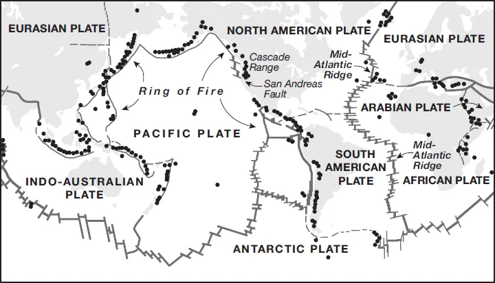
Figure 1.1. The earth’s major tectonic plates. The so-called Ring of Fire includes both transform faults such as the San Andreas Fault in California and several major subduction zones around the Pacific Rim. The dots in the figure indicate active volcanoes. (Image courtesy of USGS.)
Earthquake predictions emerge from the pseudo-science community not unlike locust plagues in the desert: not like clockwork, exactly, but often enough. In these cases seismologists can speak to the media with confidence. At best, these sorts of predictions rely on methods that might (emphasis here on might) have an underlying shred of validity—for example, the notion that tidal forces might influence earthquakes—but have never proven useful for reliable earthquake prediction. At worst they are total hooey. But every once in a while the earth puts out signals that get scientists’ attentions, leading us to wonder, is the Big One coming?
Arguably the biggest unanswered question in earthquake science is this: what, if anything, happens in the earth that sets a big earthquake in motion? The answer might be, “nothing.” Earthquakes might pop off in the crust like popcorn kernels, at a more-or-less steady rate, leaving us with no way to tell which of the many small earthquakes will grow into the occasional big earthquake. If this is the case, too bad for earthquake prediction. But at least some theories and bits of evidence suggest that earthquakes might have a detectable launch sequence.
The last great earthquake in California was over one hundred years ago. The 1906 San Francisco earthquake was recorded on a handful of early seismometers around the world, and geodetic surveying measurements made before and after the quake led directly to one of the most fundamental tenets of earthquake science. The theory of elastic rebound describes how earthquakes happen as a consequence of stress accumulation. The theory of plate tectonics, developed a half-century later, explains how and why stress accumulates. In short: plates move, the edges stay locked, the surrounding crust warps, eventually the edges (faults) move abruptly to catch up. But if the earth sent out any subtle signals that the 1906 earthquake was on the way, they were lost forever, no instruments in place to capture them.
In recent years, scientists have developed and deployed increasingly sophisticated instruments to capture signals from the earth, not only earthquake waves but also minute warping of the crust. If any subtle signals are generated prior to large earthquakes, these instruments stand ready and waiting. Data have been recorded prior to a number of recent moderate, magnitude 6–7, earthquakes in California. And they have revealed no sign of precursory signals. This negative result has led some earth scientists to conclude that there is nothing to be revealed; that, in effect, earthquakes have no launch sequence. But we have yet to see the likes of the 1906 San Francisco earthquake caught red-handed by a dense, close-in array of modern instruments. So seismologists are left to wonder what, if anything, the instruments will reveal when the next Big One strikes. Thus when instruments reveal something outside the ordinary, we are left to wonder, could this be it?
In early spring of 2005 Dollar brought his hockey-stick curves to the attention of local GPS experts. They were not immediately impressed. One geophysicist confessed that her first thought upon seeing the curves was, “What did we do wrong?” Scientists who study GPS and related data are not simply inclined toward self-doubt; they have learned to not get too excited about apparently unusual signals. GPS instruments essentially record time signals from satellites, and scientists use these signals to determine locations. The processing is notoriously complicated and capricious for a number of reasons, including the fact that the raw data have to be corrected very carefully to account for the orbits of the satellites. The results that Dollar had been looking at were from rapid—essentially quick and dirty—solutions. When researchers analyze GPS data for scientific investigations the raw data are processed more carefully. Not uncommonly, glitches in quick solutions disappear when more sophisticated processing is done.
Dollar’s hockey sticks refused to flatten out. Eventually the results came to the attention of other colleagues, not GPS gurus but rather seismologists, and they took note. Where Dollar had been thinking he might be looking at something important, some seismologists wondered if they were looking at something alarming. By this time the signals had lasted long enough that local GPS experts were also convinced they were more than a glitch. Several top seismologists sprang into action. Meetings were held. Memos were written. Blood pressures rose.
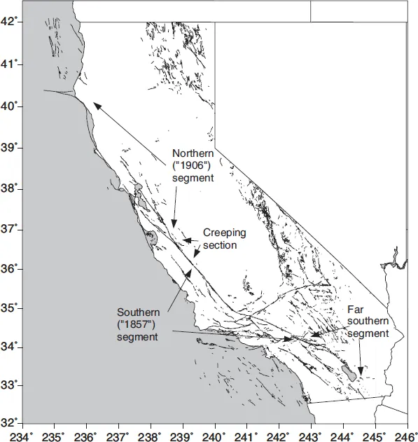
Earthquake science is not a good business to be in if one is a control freak at heart. As a seismologist, one’s career hangs at the mercy of infrequent and unpredictable events. We pursue research plans knowing that, at any moment, those plans could be blown out of the water by an earthquake that will consume all of our time and energy for months, if not years. Most of the time such thoughts can be pushed to the back of one’s mind. Every so often, it’s not so easy. Spring of 2005 was one of those times for earthquake scientists in southern California. Along with everyone else we had horrific images of the December 26, 2004 Sumatra earthquake and tsunami freshly seared onto our minds. Nor did it help that a growing body of evidence seemed to indicate that it has been a very long time, maybe too long, since the last Big One in southern California. Of particular concern, the San Andreas and San Jacinto faults in the southernmost one-third of the state, roughly from Palm Springs to near the Mexico border, have remained stubbornly locked for over three hundred years. Farther north, between San Bernardino and central California, the San Andreas Fault last broke way back in 1857 (fig. 1.2). This does not tend to be a source of comfort. The best geological evidence suggests that big quakes occur on both of these fault segments about every 150 to 300 years, maybe less. We also can’t rule out the possibility that both segments of the southern San Andreas could unzip in a single earthquake, what we sometimes call a wall-to-wall rupture. If 1857 was Big, a wall-to-wall rupture of the southern San Andreas Fault would be Bad.
A REALLY BAD ONE?
Scientists have generally discounted the possibility that the San Andreas Fault could rupture stem to stern: a single massive break running nearly the entire length of California. It is not considered likely that a rupture can propagate through a middle section of the fault that does not lock up, but along which movement occurs via steady creep. Continuing an earthquake through this section would be a bit like trying to propagate a crisp tear through a soggy patch of newsprint. As assumptions go this one is well founded. But well-founded assumptions have been wrong before.
Results from recent investigations of the southern San Andreas Fault have found their way into scientific journals and, from there, into mainstream publications. Newspapers sometimes add their own exclamation points. In late 2006, one particularly memorable headline splashed far and wide, “Southern San Andreas Fault Ready to Explode!”
Figure 1.2. The San Andreas Fault in California. Other faults in the state are also shown.
Concern for the southern San Andreas is scarcely new. The Nature paper that sparked the 2006 headlines used a new technology (synthetic aperture radar) to confirm and explore in detail a result that had been known for years, if not decades. When the curious GPS signal cropped up in the spring of 2005, every earthquake scientist in southern California knew that it had been a long time since the last Big One. But what to make of the signal? Had the complex data processing somehow gone wrong? If the earth itself had hiccupped, what did it mean?
And at what point would it be responsible to communicate concern to the public?
Earthquake scientists have come by caution the hard way. The two most notorious earthquake prediction scares in California during the twentieth century were based on apparent signs of ominous warping that turned out to be the consequence of imprecise data combined with faulty interpretation. In both of the earlier cases, the apparently ominous warping had been revealed with traditional surveying techniques, whereas the 2005 signal had been measured with modern GPS instruments. But the parallels alone were enough to give the judicious earth scientist pause. At the same time, the doubt nags at the back of one’s mind: if, as seismologists, we are seeing signals that leave us concerned, is it responsible to not communicate that concern to the public? And the doubt that nags more seriously: what if the Big One strikes while we continue to grapple with the question of going public?
Most seismologists are not quite so clueless as to admit in public that we like earthquakes. Even if it is partially true it sounds wrong. We might be geeks but we are not ghouls. When journalist Joel Achenbach commented on the fundamental communication failure that contributed to the staggering death toll of the December 26, 2004 Sumatra earthquake and tsunami, some earth scientists took exception to the perceived intimation that scientists don’t try to translate knowledge into effective communication and hazard mitigation. For most of us who work on hazard-related science Achenbach’s words weren’t accusatory but rather poignant. We do try. It isn’t easy. It especially isn’t easy when one struggles to communicate the appropriate message based on incomplete and ambiguous information. To sound alarm sirens when a tsunami wave is approaching, this is a logistical challenge. To sound an alarm when we see an unusual signal that we don’t fully understand, this is a challenge that cannot be solved with monitoring equipment and T-1 lines and sirens.
Investigations of GPS data ordinarily proceed at an unhurried pace. It takes years if not decades to collect the data in the first place. And like any scientific investigation it typically takes months to analyze the data, write up the results, and many more months for a paper to navigate the peer-review process. In the spring of 2005, a small group of scientists at the U.S. Geological Survey and the Jet Propulsion Laboratory didn’t have time. They had heartburn.
The first order of business was to check and recheck the basic processing of the GPS data. A handheld GPS receiver can track your position accurately enough to navigate on city streets, but geophysical investigations, which require millimeter-scale accuracy, are a different ball game. In addition to satellite orbit corrections, when one tracks the position of a GPS instrument, one has to ask the question, motion relative to what? Rephrasing the question in scientific terms, what is the reference frame? This might sound like a simple question; it isn’t. Using the best-available methods to process data, Tom Herring at MIT showed that part of the apparently unusual signal resulted from a subtle reference-frame issue. The magnitude 9.3 Sumatra earthquake was so enormous that it had caused small readjustments all over the planet. Taking those readjustments into account, the apparent anomaly in the Mojave Desert disappeared. The so-called San Gabriel anomaly, however, did not go away. In fact, it was revealed a fairly simple, broad and significant uplift of the crust.
Convinced that the San Gabriel signal was real, GPS experts turned to the next question: what had caused it? Was it a sign that the crust was warping suddenly (read: ominously) around the buried Whittier Fault just east of central Los Angeles? Or could the signal be hydrological in origin, the consequence of changes in ground water?
January of 2005 was a memorable month for southern Californians. Between December 27, 2004 and January 10, 2005, downtown Los Angeles received a whisker shy of seventeen inches of rain, three inches more than the city receives in an average year. Some foothill communities got soaked far worse. The rains were not only epic, they were historic. There is an unwritten law in southern California, understood by the public and agreed to by the gods: it does not rain on the Rose Parade. In 2005, for the first time in a half-century, the gods failed to hold up their end of the deal.
By 2005 scientists understood that groundwater can cause the ground to move up and down, both via natural recharge of aquifers during the rainy season and as a consequence of groundwater extraction during dry months. Usually the recharge process is gradual. But usually Los Angeles doesn’t get seventeen inches of rain in fourteen days.
Looking at the San Gabriel anomaly scientists fell in one of two camps: those who were pretty sure it had been caused by rainfall, and those who weren’t. It was really only a matter of educated opinion, how scientists sorted themselves into these camps, although the GPS experts generally remained more sanguine than—and occasionally irked by—some of their seismological colleagues. But whatever their hunches might be, GPS experts knew they had to work, and work fast, to come up with a definitive answer. Or, if not a definitive answer, at least one that settled the issue beyond reasonable doubt.
A team of scientists at the U.S. Geological Survey and Jet Propulsion Lab first worked to explore the extent of the warping using the most careful, sophisticated data processing. They confirmed that a broad swath of ground had moved upward by as much as four centimeters—not quite two inches. They then asked, could this warping be explained by a build-up of strain on a buried fault? The answer was, not easily. If strain were to suddenly build up on a fault, one would expect the warping to be centered on that fault. On the one hand the extent of the San Gabriel Valley anomaly did not coincide with any one fault. On the other hand, independent estimates of groundwater elevation—the depth of water within the earth’s crust—revealed an abrupt increase that coincided with the timing of the anomalous GPS signal. Further, by late spring of 2005, both the groundwater and the GPS trends had started to reverse; in effect, the San Gabriel Valley began to exhale, about as close as one could get to a smoking gun pointing to groundwater as the cause of the inhale.
By late summer of 2005 the scientific community was able to exhale as well. The sense of urgency defused, science resumed its usual course. Talks were presented at scientific meetings in late 2005 and early 2006. The definitive paper appeared in the prestigious Journal of Geophysical Research in early 2007. A press release went out when the paper was published, anticipating some public interest in the discovery that the San Gabriel Valley had been swelled upward temporarily by rainfall. It was a scientifically interesting result, also an impressive demonstration of the sophistication of modern instruments. A couple of local newspapers ran brief stories; otherwise, news media ignored what they sized up as news of little consequence.
The press release did not say that this was an earthquake prediction scare that never happened. Even if it had, it is unlikely that the media would have paid much attention. The dog that doesn’t bite is not news. For the credibility of earthquake science in the public are...