![]()
1
Earth and Sun
Objectives
In this chapter you will learn that:
• Earth is approximately 25,000 miles around.
• Earth rotates on its axis, which generates night and day.
• Latitude is an angle measurement used to identify a location on the surface of Earth.
• It takes Earth one year to revolve around the Sun.
• Seasons are caused by how the tilt of Earth’s axis affects the orientation of the planet as it revolves around the Sun.
• Hours of daylight are determined by Earth’s orientation with the Sun.
Size and Shape of Earth
Earth is a planet—it is a large body that moves around the Sun. It is not a perfect sphere, but Earth is a spherically shaped object. Earth has these approximate dimensions:
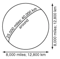
Figure 1.1. Earth is about 4,000 miles from its center to the surface (8,000-mile diameter) and approximately 25,000 miles around.
• Radius: 4,000 miles (6,400 km)
• Diameter: 8,000 miles (12,800 km)
• Circumference: 25,000 miles (40,000 km)
These values can vary slightly due to differences in surface topography and because Earth is not an exact sphere. If you could drive nonstop around the equator at 60 mph it would take seventeen days to make the trip.
What is the approximate distance around Earth (its circumference)? ________________
Answer: 25,000 miles (40,000 km)
Rotation, Poles, Equator
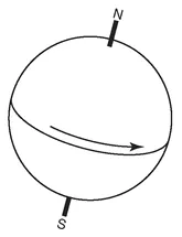
One feature of this planet is its rotation—it spins. It takes one day for Earth to rotate on its axis (one day exactly, because that is the definition of a day: one spin on its axis). Spinning leads to a reference system based on the axis of rotation. The North and South Poles are at the ends of the axis of rotation and thus can be used as unique reference points. If Earth did not spin (and thus had no rotation axis), then any place would be as good as any other for describing location.
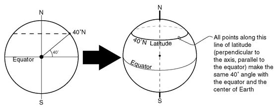
Figure 1.2. Because Earth rotates, we can identify the North Pole and the South Pole as special spots. A place on Earth will rotate once around and find itself back in the same position a day later.
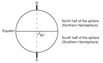
Rotation also produces another feature of interest: the equator. The equator is in a plane perpendicular to the axis of rotation, and it divides the spherical Earth into halves. All of the points on one side of the equator are closer to the North Pole than to the South Pole. All of the points on the other side are closer to the South Pole. The half of Earth closest to the North Pole is called the Northern Hemisphere (half a sphere). The half of Earth closest to the South Pole is the Southern Hemisphere.
Figure 1.3. The equator is in a plane perpendicular to the axis of rotation, and it separates Earth into two halves: the Northern Hemisphere and the Southern Hemisphere.
What is the line that divides Earth into a half that is closer to the North Pole and another half that is closer to the South Pole? ________________
Latitude
Once the two poles and the equator have been identified, then a system of measurement called latitude can be established. Latitude is an angle measurement from the equator to a point on Earth’s surface. The angle is measured from the center of Earth at the point where the rotation axis intersects the plane of the equator.
The latitude system has some simple qualities:
• All points on the equator are 0° away from the equator.
• The North Pole is 90° away from the equator.
• The South Pole is 90° away from the equator.
• If the angle is measured toward the North Pole it is called north latitude.
• If the angle is measured toward the South Pole it is called south latitude.
• North and south are important! You must state whether a place has north or south latitude to properly identify it.
Figure 1.4. All points that are the same angle away from the equator and the center of Earth have the same latitude.
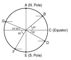
Figure 1.5.
What are the latitudes of points A, B, C, D, E, F, and G in Figure 1.5? ________________
Answer: A = 90°N, B = 40°N, C = 0°, D = 30°S, E = 90°S, F = 60°S, G = 23°30’N
Revolution around the Sun
At the same time that it is rotating on its axis, Earth also is following a path around the Sun. Earth is a planet that rotates on its axis and also revolves around the Sun.
Rotate = axis = 1 day
Revolve = orbit = 1 year
It takes one year for Earth to revolve around the Sun (one year exactly, because that is the definition of a year: one trip around the Sun). This journey also takes 365¼ days (i.e., one year). So Earth will rotate on its axis 365¼ times in the time it takes for the planet to go around the Sun and return to its departing point.
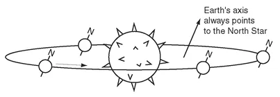
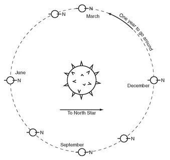
The path that Earth travels along is an ellipse—but it is very close to being a circle. The nearly circular path is used to define a geometric feature called the plane of revolution. Although the planet orbits within the plane of revolution—this is going to affect almost everything on Earth—Earth’s axis of rotation (the line running from the South Pole through the North Pole) always points toward the North Star.
Figure 1.6. It takes Earth one year to complete its nearly circular revolution around the Sun. Earth’s axis is always tilted toward the North Star.
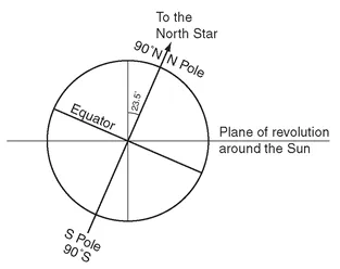
For the North Pole to be continuously directed toward the North Star, Earth’s axis has to be tilted 23½° away from perpendicular to its plane of revolution around the Sun. The direction and angle of the tilt will always be the same: the axis is always aligned toward the North Star. As a result of its constant aim to the North Star, the alignment of the axis with the Sun is always changing. For part of its revolution around the Sun, Earth’s North Pole generally leans toward the Sun, and for the other part of a year it leans away from the Sun.
• In December, the North Pole leans away from the Sun.
• In June, the North Pole leans toward the Sun.
Figure 1.7. Earth’s axis is tilted 23½° away from perpendicular to its orbit in the plane of revolution.
Figure 1.8. In this view from above Earth’s plane of revolution you can see that the North Pole is always pointed toward the North Star. This causes the orientation of Earth with respect to the Sun to always be changing.
• In March and September, the line from Earth to the Sun is perpendicular to the South Pole-North Pole axis.
Because the North Pole is always pointing to the North Star, Earth’s Northern Hemisphere is directed ________________ the Sun in June and ________________ the Sun in December.
Answer: toward; away from
Tilt and Reference Latitudes
This tilt of Earth’s axis creates five special latitude lines. These five lines are the equator, two “tropics,” and two “circle...