Chapter 1
The development of archaeological prospecting
Describing his work on Handley Down, Dorset, in 1893–5, Lieutenant-General Augustus Pitt Rivers wrote:
The ground to the west of Wor Barrow was examined to ascertain if any trace of habitations could be found, but nothing of any kind could be seen upon the surface. The pick was then used to hammer on the surface, and by this means, the Angle Ditch was discovered. The sound produced by hammering on an excavated part is much deeper than on an undisturbed surface, a circumstance worth knowing when exploring a grass-grown downland, though not applicable to cultivated ground.
Thus the great pioneer of scientific archaeology first described the use of a ‘geophysical’ method of archaeological detection, in Volume IV of his Excavations in Cranborne Chase. Elsewhere in this volume, he says that the ‘flat side’ of the pick was used, presumably the head with the handle vertical. This simple technique, which came to be called ‘bosing’, still has a place in archaeology (Atkinson, 1953) although in practice it can be quite difficult to use. It is similar in principle to modern sonic reflection techniques, which have still to be fully developed for archaeological prospecting.
Another relevant early technique, geochemical rather than directly instrumental, was phosphate detection. Especially associated with Scandinavia and developed in the 1920s by the Swedish agronomist Arrhenius (1929), its potential seems to have been first appreciated in Egypt in 1911 by F.Hughes (Russell, 1957). It is still being used and refined. Responding to enhanced phosphate concentrations in soil, derived from the waste products of man and animals, it can define general areas of habitation and in some cases can even provide quite detailed evidence of site usage. It will be discussed later in this book.
In the valley of the middle Thames, under the brooding twin hill of Wittenham Clumps, lie ancient villages and towns whose roots lie in some of the first settlements of the English. Beneath the soil are hidden in profusion vestiges of these and much older human endeavours, including the pits and ditches of mysterious sacred enclosures built at least four millennia ago. Levelled by the plough, these only become visible to modern eyes from the air in certain seasons, through their effect on the growth of crops.
One particular field at Dorchester (now a worked-out gravel pit turned into a boating lake) was the scene of famous events. At one end of it lay the Big Rings, a Neolithic monument of a type known as a ‘henge’, a ritual enclosure related to Stonehenge. The first site not on chalk to be discovered from the air, it was confirmed by O.G.S. Crawford and R.G.Collingwood by excavation in 1927. At the other end of the field more crop marks were observed by the pioneer aerial archaeologist Major G.W.G.Allen, and in 1946 Richard Atkinson made here the first geophysical survey of an archaeological site. Atkinson had written, as a postscript to the first edition of his book Field Archaeology, published that year:
As this book goes to press, the writer is investigating a method of detecting the position of bedrock, and of pits and ditches cut in it, at depths beyond the reach of a probe; it depends upon measurement of the resistance of the soil to the passage of an electric current, and has been used successfully in civil engineering. Any useful results will be published in due course.
A modest beginning to the many words that have been written on the subject since. The results were indeed useful. By the time of the next edition of Field Archaeology in 1953, resistivity prospecting had a chapter to itself. The stimulus for its development came from the convergence of two very different pressures at the end of the Second World War: the great harvest of aerial discovery (Wilson, 1982) and the rapid destruction of the riches thus revealed by reconstruction, quickening development and increasingly powerful methods of cultivation. The work at Dorchester was some of the earliest ‘rescue’ or ‘salvage’ archaeology. Gravel extraction there was rapidly approaching the features discovered by Allen, a remarkable cluster of monuments of curious forms, including henges. But the field was large, with few visible landmarks, and the photographs oblique, making the features difficult to locate precisely, so that a ground-based method of ‘remote sensing’ was urgently needed. Atkinson writes:
I came across an account of resistivity surveying quite by chance in 1946, in a civil engineering journal which had been sent to me by J. J.Leeming, then Deputy County Surveyor for Oxfordshire, which contained an article by him on roads and archaeology. He was a keen amateur archaeologist. In the same number of the journal was an article on resistivity surveying for site exploration for dams, giving the name of Evershed and Vignoles as manufacturers of the appropriate instrument. It seemed to me that the same method might be useful for detecting buried archaeological sites, and so I got in touch with Evershed and Vignoles, who generously did a skeleton survey of the site at Dorchester- on-Thames which I was about to excavate, charging me only the cost of their expenses. The results were promising, but their technique was very slow, because they were using only four equally-spaced electrodes, in the form of hollow copper tubes with a rather bluntly-pointed steel insert at the bottom, which were inserted by repeatedly dropping an iron bar into the tube. It took two whole days to survey four diametric traverses across the site about an assumed centre.
I then hired a Megger from them, and devised the system of five steel-rod electrodes and wafer switch which I have since described, and re-surveyed the site. This is how it all began.
I gave the first public account in a lecture to the Society of Antiquaries on 16 January 1947, the same day that I was admitted Fellow. The then Editor of the Antiquaries Journal declined to publish it, as too technical. In 1951 I was invited to contribute a chapter on resistivity surveying to a French book, La découverte du passé (Paris: Picard, 1952), edited by Mlle Annette Laming, who had worked with me on excavations at Dorchester, located by this means. The first British publication was in the second edition of my Field Archaeology.
In testing resistivity, Atkinson must also have been influenced by the fact that the soil moisture variations that it responds to are also a major contributor to the creation of the crop marks that reveal such sites as his. He was able to persuade the Ashmolean Museum, for which he worked, to purchase a Megger Earth Tester. The Museum also houses the archive of Major Allen’s air photographs, and in 1948 staged the first exhibition of these. By one of those chances that shape lives, I was working nearby for the Inter-Service Photographic Interpretation School, RAF Nuneham Park, and was greatly impressed by both the exhibition and the resistivity work at Dorchester, only three miles away. At Cambridge, the post of Curator in Aerial Photography was newly established. Remote sensing in archaeology was on the move.
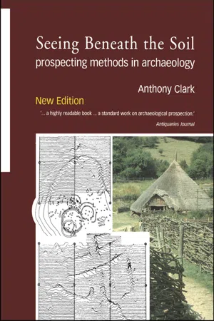
The Megger Earth Tester in those days was built in the venerable tradition of mahogany and brass (Fig. 1). It was powered by a hand-driven generator producing a high enough voltage to make handlers of uninsulated probes jump, and the method of operation was a fine example of electromechanical technology. The Megger was well established for soil studies in civil engineering, in which it was mainly used at fixed stations where the spacing between the four necessary probes was varied for soil testing in depth. The basic requirement of archaeological prospecting is different: rows of readings are taken at constant probe spacing on the assumption that undisturbed ground will give fairly uniform values, while archaeological features will cause anomalous readings (simply known as ‘anomalies’) that will stand out when the survey is plotted. Atkinson worked out a novel, rapid method of survey called the ‘leapfrog’ and the switching system to operate it, which he alludes to above and will be described in Chapter 2.
Fig.1. Diagram of Megger Earth Tester arranged for Wenner resistivity measurement.
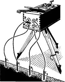
Fig.2. Contour plan of one of the first resistivity surveys of a site at Dorchester-on-Thames. Values in ohm-feet. The actual ditches as excavated are shown by stippling. After Atkinson (1963).
The simplest way to represent lines of readings is by graphs, but Atkinson readily appreciated the value of area surveys with their potential for revealing man-made patterns in plan. The Dorchester survey shown here was a good example of this early work (Fig. 2).
The Dorchester sites, consisting of moist, silted- up features cut into well-drained gravel, gave encouragingly clear resistivity responses. For 12 years from 1946, when Atkinson initiated the technique, resistivity, mainly with the Megger, remained the sole instrumental method for detecting and planning archaeological sites, although subsequent success was variable. In the 1950s, technology advanced: the transistor was available, and allowed the development of circuits which could be complex, yet compact, highly reliable and low in power consumption. This encouraged John Martin and myself in 1956 to develop a resistivity meter with archaeology specifically in mind—the Martin-Clark, a spin-off from our work in the Distillers Company Instrumentation Section during its extraordinary and enlightened first years under the late Charles Munday. version was a simple two-electrode, transistorized Wheatstone bridge, and even this, in spite of contact resistance problems, was readily able to detect the massive foundations of the defensive wall around the town (Clark, 1957). This led quickly to the development of a more suitable instrument using a basically conventional manual null balance circuit and a newly designed switch that simplified Atkinson’s leapfrog probe-moving method(Fig. 3). The null balance of the circuit was initially detected audibly, using earphones, but because of problems with subjectivity in judging a rather imperfect null, this was replaced by a dial.
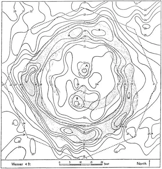
The Roman town of Cunetio, in Wiltshire, had recently been discovered from the air by J.K.S. St Joseph, the Curator at Cambridge. Excavations there, directed by Kenneth Annable, first with Hid Anthony and subsequently myself, provided a test- bed for the new instrument. The first
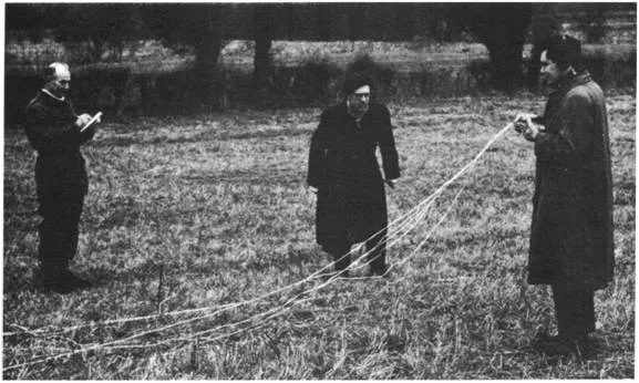
Fig.3. (Bottom) Using the prototype Martin-Clark meter at Cunetio. Left to right: Richard Sandell, Kenneth Annable and the author. A problem: trying to revive flat batteries with a candle borrowed from the local pub.
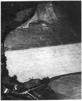
Fig.4. Cunetio, Wiltshire. One of the air photographs taken by J.K.S. St Joseph which revealed the defences of the Roman town, looking east. The arrows point along the crop marks of the east wall and the south wall with two visible bastions.
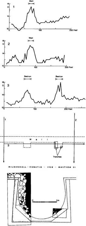
Fig.5. (Right) The Cunetio bastion search. (1) and (2) are traverses across the wall foundation to establish its position. On the basis of these, (3) was laid out parallel with its outer face so as to intersect the bastions. The graphs show that the resolution of the meter was 0.2 ohm. A minimal excavation of the bastion giving the larger anomaly—and therefore likely to be the better preserved—is shown in the bottom plan. It was just sufficient to produce the information required: the plan of the bastion, and the fact that it was integral with the wall and not a later addition. Traverses (1) and (2) also show indications of the earlier ditch system visible on the air photograph.
The value of archaeological geophysics was brought home to me when I arrived late at the site after a struggle with some instrumental problem. On the basis of estimates from the oblique air photographs, the archaeological team had cut a substantial trial trench in search of the town wall, which subsequent resistivity measurements showed to be about 7 m (23 ft) away. The instrument was used to trace the whole circuit of this wall, and the search for the bastions provided a fine and convincing example of the economy of effort achievable by a geophysical technique (Figs. 4, 5). This prototype is now in the Science Museum.
Meanwhile, another momentous development was under way. It had been known since the nineteenth century that fired clay, including pottery, was weakly magnetic. Clays contain iron oxides which are magnetized by the Earth’s field as they cool down from high temperatures. By this process, called thermoremanent magnetization, the direction of the geomagnetic field at the time of use is fixed in the kiln. This direction changes over the years and the date is determined by making measurements on samples taken from the kiln, matched against a reference curve of the directional changes in the Earth’s field with time.
In 1957, the Canadian physicist John Belshe gave a lecture to the Society of Antiquaries reporting on pioneering work at Cambridge on this method of dating in Britain. In the discussion following the lecture, Graham Webster asked if it would be possible for a magnetometer to detect buried burnt clay, such as a pottery kiln. Belshe said he could see no reason why it should not; in fact, he had demonstrated the previous year that a kiln would produce an appreciable magnetic signal. Webster had good reason to ask this question. The Al Great North Road was being improved, and there was evidence that there could be pottery kilns somewhere along the 3-km (2-mile) stretch to be re-routed and widened past the Roman town of Durobrivae, at Water Newton near Peterborough. He was in overall charge of the daunting project of searching this lengthy strip of ground for kilns, unti...