Geography
Coasts Geography
Coastal geography is the study of the dynamic interface between land and sea. It encompasses the physical processes, landforms, ecosystems, and human activities that shape and are shaped by coastal environments. Key concepts include erosion, deposition, coastal landforms, sea level change, and the impact of human activities on coastal areas.
Written by Perlego with AI-assistance
Related key terms
1 of 5
12 Key excerpts on "Coasts Geography"
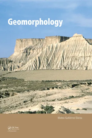 eBook - PDF
- Mateo Gutierrez(Author)
- 2012(Publication Date)
- CRC Press(Publisher)
11 COASTAL GEOMORPHOLOGY 1. Introduction 2. Brief history of coastal geomorphology 3. Temporal and spatial scales 4. Sea level variations 5. Waves, currents, and tides 6. Cliff coasts and rocky platforms 7. Coral reef coasts 8. Beaches, barriers, and spits 9. Coastal dunes 10. Mudflats, salt marshes, and mangroves 11. Estuaries and deltas 12. Coastal environments: Uses, management, and risks 11.1 Introduction Bird (2000) defines coastal geomorphology as the study of the evolution of coastal landforms, the processes that affect them, and the changes they undergo. These landforms include cliffs, rocky coastal margins, beaches, dunes, estuaries, lagoons, and deltas. The world’s coastal margins are about 100 m wide and 440,000 km long; humans use them for industrial pur- poses, transportation, and recreation. These human activities profoundly impact these areas. The United Nations estimates that 66% of the world’s population lives within a few kilom- eters of the coast (Pethick, 1984). As a result, food produc- tion, communication, cities, and recreational areas all affect the coast. Coasts have significant problems that include flood- ing, erosion, pollution, and sea level variations that require constant attention. Interdisciplinary studies by coastal engi- neers, oceanographers, and geomorphologists have led to significant advances in coastal management (Stephenson and Brander, 2003). In addition, coasts are constantly changing; the change may be catastrophic or imperceptible. Modifica- tions may occur over decades or centuries but they can also take place in a period of hours or minutes. 11.2 Brief history of coastal geomorphology Prior to the 20th century, research on coastal geomorphology was limited to engineering topics related to coastal erosion (Walker and MacGraw, 2005). Charles Darwin made impor- tant observations on coral reefs and the origin of atolls during his famous voyage on the British ship, the Beagle, in 1835 (Shepard, 1959).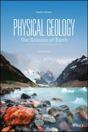 eBook - PDF
Physical Geology
The Science of Earth
- Charles Fletcher(Author)
- 2017(Publication Date)
- Wiley(Publisher)
With so much of our culture and economy focused today on the shoreline, it is essential that geologists advance the scientific understanding of coastal environments and provide reliable data that can be applied to improving management plans and programs. To that end, in recent decades a new field of study, coastal geology, has emerged. Coastal geology is concerned with understanding coastal processes (such as how waves and currents move sediment), the geologic history of coastal areas, and how humans live in coastal environments (Figure 20.2). Shorelines Are in a State of Perpetual Change 615 FIGURE 20.2 Trash like this washes up on beaches around the world because humans have been polluting the ocean for decades. Peter Chadwick/Getty Images, Inc. What are the potential consequences of dumping garbage in the ocean? Coastal Processes Sediments in the coastal zone may come from watersheds (typ- ically, siliciclastic grains) as well as from the ocean (typically, calcium carbonate). Winds, waves, and currents transport and deposit these sediments, thereby shaping various coastal environments—beaches, estuaries, deltas, wetlands, and reefs. Since the last ice age, a rising global sea level (over 120 meters) has flooded river mouths, drowned low-lying coastal lands, and shifted the coastline landward, in many cases over hundreds of kilometers. Winds, waves, tides, sea level change, and currents act as agents of change, collectively called coastal processes. They sculpt the shoreline through erosion and deposition of sedi- ment and by flooding low areas. Understanding how coastal processes and sedimentary materials interact is crucial to inter- preting the geologic history of coastal systems and finding ways for people to live in the coastal zone in a sustainable manner. Coastal Terminology Scientists employ a number of specific terms when describing the coastal zone.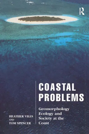 eBook - ePub
Coastal Problems
Geomorphology, Ecology and Society at the Coast
- Heather Viles, Tom Spencer(Authors)
- 2014(Publication Date)
- Routledge(Publisher)
Chapter Two HOW COASTS WORK IntroductionFrom the dramatic, precipitous cliffs of the Banks Peninsula, South Island, New Zealand to the palm-fringed, gleaming white, coral sands of a Seychelles beach there is an almost infinite variety of coastal scenery. In any one place the coastal zone consists of the same basic components (water, air, sediments, rocks and organisms), but how they are structured depends on a range of factors including geology, climate and oceanographic regime. Contemporary processes interact with landforms produced by past changes in sea level, sediment supply and process regime. Many North American and north-west European coasts, for example, show strong legacies, in terms of sea level change and recent sediment supply, from the repeated advance and retreat of large ice sheets over the last 1–2 million years.Many attempts have been made to classify and explain the diversity of coastal environments using genetic or descriptive criteria, or a mixture of the two. Thus Johnson (1919) split coasts into submergent, emergent, neutral and compound, depending on their recent history of relative sea level, Shepard (1963) divided coasts according to the relative importance of coastal and non-coastal processes, recognizing primary coasts (virtually unmodified by coastal processes) and secondary forms, and Davies (1964, 1972) split the world’s coastline up according to wave activity leading to a division into high latitude storm wave coasts, low latitude swell wave coasts and low energy coasts. Clearly all these different approaches are of value. Here we recognize the importance of variations in geological structure, sea level history and biogeography in providing contexts within which both contemporary ecological and geomorphological processes act and future environmental changes will be placed.Plate tectonics and coastal typeInman and Nordstrom (1971) produced an important classification based primarily on plate tectonics. They define three major coastal scales as shown in Table 2.1 . The controls operative at the first and second order provide a classification (tectonic and morphological) for the whole coastal zone. The controls operating at the third order help classify features within the shore zone. Coastal type at the large scale, therefore, is determined by the position of the area relative to plate margins, leading to a division of the world’s coastline into collision, trailing-edge and marginal sea coasts (Fig. 2.1 ). Collision, or active margin, coasts are typically characterized by the delivery of relatively coarse sediments from mountainous catchments to a coastal zone characterized by a narrow continental shelf and deep water not far offshore. Trailing edge, or passive margin, coasts by comparison are fed by large rivers often draining enormous drainage basins, thus contributing large volumes of fine sediments to wide, low-angle continental shelves. Most of the world’s major deltas are associated with trailing-edge coasts and they are also characterized by extensive barrier island development. Collision coasts, as in the Mediterranean and south-east Asia, often support only rocky shorelines, with poor beach or reef development, and exhibit sea level histories complicated by regional tectonic movements. These controls help provide a basis for the second order of Inman and Nordstrom’s (1971) classification (Table 2.2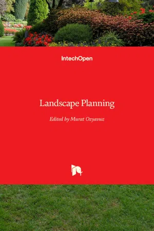 eBook - PDF
- Murat Ozyavuz(Author)
- 2012(Publication Date)
- IntechOpen(Publisher)
Ecological Landscape Planning, with a Focus on the Coastal Zone 241 Ecological features and natural resources found in coastal zones, which penetrate from the coastline into the land to a certain degree, have an influence on human life and make it possible for them to benefit from coastal zones in different ways. Among the natural resources in coastal zones are (Arslan, 1988): -Wetted areas and outfall bays, -Alluvial pools, which resemble lagoons in shape, formed in coastal areas following tidal currents, -Natural resources that must be protected for future scientific research, and educational, instructional and social activities, -Arable areas and those areas that are suitable for forestry, -Reserve areas, -Mineral deposits, -Beaches and dunes, -Areas and waters that can be used for recreation, -Visual features. In addition to their natural structures and biological diversities, coasts are an ecosystem in which nature is connected to cultural texture and different types of flora/fauna communities with different characteristics are enabled to live, reproduce and grow. Establishing a strong link between land and sea resources, coastal ecosystems play a key role in regulating the life quality of living creatures. The circle in coastal ecosystems is closely intertwined with and depends heavily on the natural structure of coastal zones, their geological features, their micro-climatic impacts, their hydrologic features, their flora and fauna, their soil structure, human activities, cultural structures and the way human beings use water. Coastal zones are dynamic compositions that can be different depending on the quality and intensity of human activities on them. One of the most significant factors in landscape, population growth has rapidly caused human beings to diversify their demands on coastal resources, which, in turn, has led to an increase in use pressure on unit area.
- Yeqiao Wang(Author)
- 2022(Publication Date)
- CRC Press(Publisher)
Te coast and its adjacent areas on and of shore are an important part of a local ecosystem as the mixture of fresh water and salt water in estuar- ies provides many nutrients for marine life. However, coasts also face many environmental challenges including natural hazards and human-induced impacts. Currently, more and more issues face coastal managers: coastal storms and coastal habitat loss caused by land use, pollution, sea-level rise, and some other issues are becoming increasingly prominent. Management and protection of coastal environments to achieve the sustainable development of coastal zone are arduous and long-term tasks for humankind. Te coast, which is shaped by a variety of diferent forces, is a complex dynamic system and the coastal environments are also diverse. Due to space limitations, this entry cannot include detailed descriptions for each coastal environment but hopefully it can help the reader gain a general understanding about coastal environments. References 1. McLean, R.F.; Tsyban, A.; Burkett, V.; Codignotto, J.O.; Forbes, D.L.; Mimura, N.; Beamish, R.J.; Ittekkot, V. Coastal zones and marine ecosystems. In Climate Change 2001: Impacts, Adaptation and Vulnerability; Cambridge University Press: United Kingdom, 2001. 2. Woodrofe, C.D. Introduction. Coasts: Form, Process and Evolution, 1 st Ed.; Cambridge University Press: Cambridge, United Kingdom, 2003. 3. Kusky, T. M. Introduction. Te Coast: Hazardous Interactions within the Coastal Environment; Facts on File, Inc.: New York, 2008. 4. Stutz, M.L.; Pilkey, O.H. Open-Ocean Barrier Islands: Global Infuence of Climatic, Oceanographic, and Depositional Settings. J. Coast. Res. 2011, 27 (2), 207–222. 5. Stone, G.W.; McBride, R.A. Louisiana barrier islands and their importance in wetland protec- tion: forecasting shoreline change and subsequent response of wave climate. J. Coast. Res.1998, 14, 900–915. 6. http://www.dep.state.f.us/coastal/habitats/saltmarshes.htm (accessed March 2012). eBook - PDF
Oceanography
An Invitation to Marine Science
- Tom Garrison(Author)
- 2015(Publication Date)
- Cengage Learning EMEA(Publisher)
Due to electronic rights, some third party content may be suppressed from the eBook and/or eChapter(s). Editorial review has deemed that any suppressed content does not materially affect the overall learning experience. Cengage Learning reserves the right to remove additional content at any time if subsequent rights restrictions require it. CHAPTER 12 336 12.1 Coasts Are Shaped by Marine and Terrestrial Processes Coastal areas join land and sea. Our personal experience with the ocean usually begins at the coast. Have you ever wondered why a coast is in a particular location or why it is shaped as you see it? These temporary, often beautiful junctions of land and sea are subject to rearrangement by waves and tides, by gradual changes in sea level, by biological processes, and by tectonic activity. The place where ocean meets land is usually called the shore , and the term coast refers to the larger zone affected by the processes that occur at this boundary. A sandy beach might form the shore in an area, but the coast (or coastal zone) includes the marshes, sand dunes, and cliffs just inland of the beach, as well as the sandbars and troughs immediately offshore. The world ocean is bounded by about 1,000,000 kilometers (620,000 miles) of shore, about one third of which are sandy beaches (Figure 12.1) . Because of its proximity to both ocean and land, a coast is subject to natural events and processes common to both realms. A coast is an active place. Here is the battleground on which wind waves break and expend their energy. Tides sweep water on and off the rim of land, rivers drop most of their sediments at the coasts, and ocean storms pound the continents. The location of a coast depends primarily on global tectonic activity and the volume of water in the ocean. The shape of a coast is a product of many processes: uplift and subsidence, the wearing down of land by erosion , and the redistribution of material by sediment transport and deposition. eBook - ePub
- Simon K. Haslett(Author)
- 2016(Publication Date)
- University of Wales Press(Publisher)
section 1.1.1 is very much for the use of physical scientists studying the coast. However, for planning and management purposes, where administration is involved, the coastal zone is much more variably defined. Kay and Alder (2005) give a range of definitions used by various organisations in international and national government. Some definitions are known as distance definitions, whether fixed or variable, where the coastal zone is defined as being so many kilometres landward, and so many nautical miles seaward, of the shoreline. Other definitions do attempt to recognise and incorporate aspects of the working complexity of the coastal zone. In abbreviated form, these include:- ‘the coastal waters and the adjacent shorelands strongly influenced by each other, and includes islands, transitional and intertidal areas, salt marshes, wetlands and beaches. The zone extends inland from the shorelines only to the extent necessary to control shorelands, the uses of which have a direct and significant impact on the coastal waters’ (United States Federal Coastal Zone Management Act)
- ‘as far inland and as far seaward as necessary to achieve the Coastal Policy objectives, with a primary focus on the land-sea interface’ (Australian Commonwealth Coastal Policy)
- ‘definitions may vary from area to area and from issue to issue, and that a pragmatic approach must therefore be taken’ (United Kingdom Government Environment Committee)
- ‘the special area, endowed with special characteristics, of which the boundaries are often determined by the special problems to be tackled’ (World Bank Environment Department).
Coasts are not static environments and are in fact highly dynamic, with erosion, sediment transport and deposition all contributing to the continuous physical change that characterises the coast. Such dynamism requires energy to drive the coastal processes that bring about physical change, and all coasts are the product of a combination of two main categories of processes driven by different energy sources (Fig. 1.1 ):- The first category of processes is known as theendogenetic processes, so-called because their origin is from within the earth. Endogenetic processes are driven by geothermal energy which emanates from the earth’s interior as a product of the general cooling of the earth from its originally hot state, and from radioactive material, which produces heat when it decays. The flux of geothermal energy from the earth’s interior to the surface is responsible for driving continental drift and is the energy source in the plate tectonics theory. Its influence on the earth’s surface, and the coast is no exception, is to generally raiserelief
 eBook - PDF
- Gerd Masselink, Roland Gehrels, Gerd Masselink, Roland Gehrels(Authors)
- 2014(Publication Date)
- American Geophysical Union(Publisher)
Coastal Environments and Global Change, First Edition. Edited by Gerd Masselink and Roland Gehrels. © 2014 John Wiley & Sons, Ltd. Published 2014 by John Wiley & Sons, Ltd. Companion Website: www.wiley.com/go/masselink/coastal 3.1 Geology and sediments: setting boundary conditions for coasts 3.1.1 Coastal diversity: a heritage of geology and sediments Coasts are extremely diverse in their morphology and sedi- mentary composition, and this diversity is largely explained by geology and by the sediments accumulating on coasts (Fig. 3.1). The geology determines the primary boundary condition within which the coast is formed and within which the processes of coastal evolution operate. The coastal boundary corresponds to the land-ocean interface, and involves a consideration of the overall tectonic frame- work and lithology. Embedded in these primary boundary conditions are sediment type and input. Three other impor- tant factors are the coastal space available for sediment to accumulate, called ‘accommodation space’, the topography, and the orientation of the coast, all of which reflect primary geological controls as well as the influence of sediment storage and redistribution in the coastal zone under the influence of coastal processes. Overall, therefore, coasts may range, in their morphology, from primary types hinged 3 Environmental Control: Geology and Sediments EDWARD J. eBook - PDF
Rediscovering the Golden State
California Geography
- William A. Selby(Author)
- 2018(Publication Date)
- Wiley(Publisher)
An inter- face where land, atmosphere, fresh water, and ocean meet, the coastal strip is an ideal place to recognize profound connections between natural and human processes that are shaping California. From coastal bluffs covered with forests to delicate sand dunes, from wide sandy beaches to some of the most modern and dense human developments, the California coast displays excellent examples of the importance of the themes that run throughout this book— connections, diversity, and change. These shorelines may appear—as backdrop, setting, or star—in more films than any other landscapes on our planet. It is no surprise that most Californians and visitors consider the state’s shorelines unequaled and irreplaceable jewels. These are perfect settings for us to apply geography to better examine and solve problems. Coastal Geomorphology Such a fascinating story must begin with cycles of matter and energy that have shaped the coast for thousands of years. Internal (endogenic), mountain-building forces have folded and faulted coastal landscapes above the sea. There are countless examples of dramatic, steep land- scapes that result when mountains are lifted vertically out of the ocean; you will find them from the Oregon border to the northern Coast Ranges’ King Range to Big Sur’s Santa Lucia Range, and from Point Conception to the Mexican border. No doubt, these modern events and landscapes are evidence of enduring processes that have gradually, for millions of years, lifted California out of the water, from the east to the west. Rather than falling into the sea, most coastal Californians are gradually ris- ing above it. External mass wasting processes deliver many of the steeper slopes directly back into the ocean, where waves can reshape and carry the debris out to quieter waters or other distance shorelines. Rocky coasts, bluffs, and cliffs are left behind to precariously dangle until the next land- slide. eBook - PDF
- R. Knowles, J. Wareing(Authors)
- 2014(Publication Date)
- Made Simple(Publisher)
PART ONE: THE STUDY OF ECONOMIC AND SOCIAL GEOGRAPHY CHAPTER ONE MAN AND ENVIRONMENT Geography is currently going through an exciting period in its development as new problems are identified and new methods of analysis are formulated. It is not easy to say precisely what geography is about because geographers often hold different views of the subject, and these views change from time to time, but this is not surprising since geographers are interested in a very wide range of problems and rapid advances are being made in the subject, as they are in all branches of knowledge. Because geography involves such a wide range of knowledge, the subject has been divided into two major areas of study. The first of these is physical geography, which is concerned with the physical environment of landforms, weather and climate, soils, and plants and animals (see Physical Geography Made Simple). The second is human geography, which is concerned with man's activities over the surface of the earth. In many ways this is a false distinction since the activities of man take place within the physical environment, and the physical environment is considerably affected by these activities, but the divi-sion is a useful one and in this book the physical environment will only be considered in relation to man. Human geography can be studied in two principal ways. First, the earth's surface can be studied part by part. This is the approach of regional geography, which seeks to understand the unique character of an area as produced by the interaction of human activity and the physical environment. Secondly, human activity over the earth's surface can be studied part by part. This is the approach of systematic geography, which isolates particular elements such as agriculture, industry or transport, and seeks to understand their spatial patterns and the processes which have produced them. eBook - PDF
- Tom Garrison, Robert Ellis(Authors)
- 2017(Publication Date)
- Cengage Learning EMEA(Publisher)
Coastal environments have been evolving for millions of years and we should not presume to be able to stop that. If we continue to do so, scenes like the one shown in Figure 8.29 will likely become more common. Let’s enjoy them in their present stages. Copyright 2018 Cengage Learning. All Rights Reserved. May not be copied, scanned, or duplicated, in whole or in part. WCN 02-300 CHAPTER 8 174 TERMS AND CONCEPTS TO REMEMBER backshore backwash barrier island bay bay mouth bar beach beach nourishment beach scarp berm berm crest breakwater coast coral reef delta depositional coast erosion erosional coast estuary eustatic change fjord fjord estuary foreshore groin headlands high-energy coast inlet jetty lagoon longshore bar longshore current longshore drift longshore trough low-energy coast mangrove marine terrace partially mixed estuary salt wedge estuary sand spit sandbar sea arch sea cave sea cliff sea island sea stack shore swash tombolo wave-cut platform well-mixed estuary In this chapter you learned that the location of a coast depends primarily on global tectonic activity and the ocean’s water volume, whereas the shape of a coast is a product of many processes: uplift and subsidence, the wearing down of land by erosion, and the redis-tribution of material by sediment transport and deposition. Coasts are classified as erosional coasts (on which erosion dominates) or depositional coasts (on which deposition dominates). Natural rock bridges, tall stacks, and sea caves are found on erosional coasts. Depositional coasts often support beaches, accumulations of loose particles. Generally, the finer the particles on the beach, the flatter Chapter in Perspective its slope. Beaches change shape and volume as a function of wave energy and the balance of sediment input and removal. Deltas and estuaries form where freshwater meets the ocean. Coral reefs and mangroves are among the most complex and biologically productive coasts. eBook - PDF
- Alan F. Arbogast(Author)
- 2017(Publication Date)
- Wiley(Publisher)
Geographers were involved in mapping the extent of the spill and the coastal zones that were potentially harmed. This sec- tion will discuss some of the ways humans impact coastlines. Coastal Engineering One of the most obvious ways that people impact the coastline is through engineered structures. Although these structures come in a wide variety of forms, they are generally built with the idea of (1) protecting the shore and shorefront homes from coastal hazards such as erosion and storm surges, (2) stabi- lizing and nourishing beaches, or (3) maintaining or improving the flow of trade or traffic into ports. Shoreline Protection Of the many people who live near U.S. coastlines, a large number choose to reside or work directly on the shore (Figure 19.35). The reasons for this choice are probably obvious, as the shore is a pleasurable landscape in which to live and work, with spectacular views and numerous Human Interactions with Coastlines 459 recreational opportunities. However, coastlines are one of the more sensitive landscapes on Earth, with changes occur- ring on a daily basis and major adjustments taking place when strong storms such as hurricanes strike. Although extreme events such as hurricanes are indeed dangerous, they are statistically rare along any particular stretch of coast. As a result, people tend to be much more concerned about the erosion associated with less severe storms, waves, and high-water level. Unchecked, the effects of shoreline erosion on coastal communities can be disastrous (Figure 19.36). In an effort to control these effects, people have devised a variety of protective structures. Perhaps the most common way people attempt to mitigate coastal erosion is to build sea walls and revetments that armor the shore. As the name implies, a sea wall is a vertical, wall-like structure built along the coast, usually at the landward edge of a beach, where a bluff or dune may occur. Figure 19.37 shows a sea wall at Palm Beach, Florida.
Index pages curate the most relevant extracts from our library of academic textbooks. They’ve been created using an in-house natural language model (NLM), each adding context and meaning to key research topics.