![]()
1 Introduction
Geophysics is a discipline that is relatively unknown to most people. Many might consider it related to Earth sciences; however, in its broadest sense, geophysics goes beyond the Earth and even solid planetary boundaries. One professional society with geophysics in its name has among its membership oceanographers, meteorologists, astronomers and geologists. Here, geophysics is given the more specific definition of noninvasively characterizing the underground. The manner in which this is accomplished can range from relatively simple to quite complex. In this sense, it is similar to diagnostic medicine where x-rays might be employed to determine if a bone is broken and, at the other extreme, elaborate procedures such as CT scans might be required. The basis common to both geophysics and these types of medical evaluations is that the methods exploit principles of physics. Thus, physics and geophysics are inseparable and any discussion of geophysics, even an elementary one, must consider the underlying physics.
Historically and traditionally, geophysics has been a discipline used to characterize the large-scale, deep structure of the Earth and for petroleum and mineral exploration. For these applications, the most commonly used geophysical method is seismics, where the word seismic means vibrations within the Earth and, hence, this method exploits measurements of vibrations made on the Earth's surface to characterize deep geologic structures. For the above-cited applications, vibrations are artificially created on the ground surface and these vibrations travel into the Earth in the form of waves. These waves then pass through or bounce (reflect) off of various subsurface features and ultimately some of this vibrational energy arrives back at monitoring locations on the Earth's surface. Geophysicists can interpret the recorded vibrations to construct 'pictures' of the Earth's structure.
When vibrations or other forms of energy are artificially created for the sole purpose of geophysical investigations, such geophysical methods are referred to as active. Another class of geophysical methods involve those where energy is created within the Earth or imparted to the Earth by natural forces or are artificially created for purposes other than geophysical investigations. Because the energy that is exploited exists independently of the geophysical study, this class of techniques is termed passive. There are numerous, well-known passive applications of seismic methods. Relatively weak vibrations are frequently precursors to earthquakes and volcanic activity so seismic waves received at networks of monitoring stations can be used for the short-term prediction of these events. These networks can also be used to detect and locate powerful explosions and, for this reason, they have been used to establish compliance with nuclear test ban treaties. The detonation in April 1995 of a bomb at the federal building in Oklahoma City was detected at seismic monitoring stations.
Along with passive seismic monitoring, there have been several important more recent applications of geophysics—most notably, geotechnical and environmental engineering. Geophysics in geotechnical engineering is concerned with the characterization of the shallow subsurface in support of construction activities. In general, these applications involve delineation of soil/rock interfaces or the identification of the location and extent of groundwater. For most construction activities, it is important, if possible, to avoid groundwater since excavation in water-saturated soils can be far more expensive than excavation in dry soils and can impact worker safety. In a recent incident, an intersection in Los Angeles was flooded when unanticipated groundwater was encountered during the excavation for a subway system. Since excavation in rock is costlier than excavation in soil, construction costs can be minimized through the timely application of geophysics to locate shallow rock ledges. With this knowledge, slight modification to the location of the facility on a site can be made and these excavation complications can be avoided. For other construction activities, the presence of shallow rock is desirable. One such case is tunnels. While it is more expensive to bore through rock, tunnels are less likely to collapse and require less reinforcement when they are developed in rock. Consequently, geophysics is relied upon in the routing of tunnels so as to maximize the extent of tunnel passing through rock. In order to prevent the settling of large structures, particularly those built on soft soils, it is essential that these structures be anchored to solid rock. Geophysics can be used to quantify the depth to solid rock, so that such structures can be appropriately sited.
In environmental engineering, geophysics is frequently used to characterize the shallow subsurface and to locate buried waste. Specifically, applications include locating drums of toxic substances, mapping contaminant plumes, identifying preferential pathways for the migration of buried contaminants, and evaluating candidate sites for waste disposal.
One of the most common current uses of geophysics is for the detection, location, and identification of buried bombs and mines. Recent conflicts in eastern Europe, Africa, southeast Asia, and the Middle East have created a legacy of hazards to civilian populations in the form of shallowly buried land mines. Humanitarian efforts are now underway to render these areas safe. Similarly, the Unites States military has used thousands of square kilometers for practice bombing and artillery ranges. Not all of these ordnance have exploded on impact but rather have penetrated the ground and remain a hidden threat. An act of Congress requires the closure of many military bases followed by a conversion to civilian uses. Almost all of these facilities pose some environmental hazard that must be remediated prior to conversion and many contain buried unexploded ordnance. Millions of dollars per year are currently being spent on geophysics as a first step in the remediation of closed military bases.
While geophysicists and scientists in related disciplines will find these applications interesting, to most non-scientists they may be mundane. However, there are many quite recent applications of geophysics that are of general interest. These include national security, counter-narcotics, intelligence and counter-intelligence, archaeology, paleontology, and law enforcement.
This book is an introductory reference on the basic principles of geophysics specifically aimed at those with a minimal background in mathematics and physical sciences but more than a casual interest in the application of geophysics to archaeology. The specific geophysical techniques considered here can be categorized as static and dynamic methods. Static refers to a quantity that does not change over time and, in the case of geophysical methods, static techniques exploit forms of naturally occuring or made-made energy that are constant over time. In contrast, dynamic techniques in geophysics are those that use time-varying energy forms to probe the Earth. Specific elements presented are:
- Gravity—This is an attractive force between objects. This force is responsible for the orbit of planets around a star, the orbit of moons around planets, etc., and is what prevents objects on the surface of the Earth from floating off into space. The Earth's gravitational force (pull) is quite predictable and measured deviations from this are indications of underground features such as rock masses, meteors, and tunnels.
- Magnetostatics—The Earth is immersed in a magnetic field. This field can be thought of as being produced by a giant bar magnet located at the Earth's center. This field does not change over time and varies over the surface of the Earth in a simple and predictable manner. By measuring the intensity of the magnetic field, the presence, type, location, and size of buried features can be inferred from unexpected deviations in the field strength.
- Electromagnetic Induction—This exploits time-varying magnetic fields and is the transient counterpart to magnetostatics. While not a well-known term, electromagnetic induction is the basis for the generation of electricity, microwave cooking, and other less well-known applications. In geophysics, this effect has been used for mineral exploration, to map groundwater and geologic boundaries, and to detect buried metal objects. Under favorable conditions, electromagnetic induction has been successful in delineating buried stone walls.
- Waves—These are well known to everyone since they are directly sensed in the form of light and sound. Waves created in one medium can change when encountering a different medium. For example, sound waves created in air can produce echoes when they interact with a canyon. Light waves created in air will bend when passing through glass or plastic and this bending is used to create lenses to magnify or correct vision. In geophysics, the interaction of waves with subsurface inhomogeneities, such as rock layers, oil and mineral deposits, etc., can be used to characterize these inhomogeneities.
- Ground Penetrating Radar—This is a particular wave-based technique that uses one type of wave, radio or radar waves, to characterize the shallow underground. It is analogous to the better known upwardly looking radar used in weather forecasting and air traffic control.
This list of methods is by no means comprehensive but is limited to those techniques that are applicable to shallow underground exploration, that might commonly be used in archaeology, and are sufficiently simple that their applicability can be assessed, implementation executed, and interpretation performed without having rigorous training in geophysics. It should not be inferred from this statement that this book provides all the necessary knowledge required to be a practicing geophysicist. There are many subtleties and potential pitfalls that can render a particular technique ineffective or the interpretation of acquired data quite difficult. For this reason, geophysics is best left to the professionals. The motivation for this book is to provide a reference for archaeologists and others interested in near-surface geophysical applications to assess the viability of these specific geophysical methods for site investigations and, in most cases, to allow them a reasonable understanding of data interpretation.
A geophysicist reading this book may question the inclusion of gravity as an important method in archaeology. While gravity can be used to locate shallowly buried stone walls, vaults, tombs and caves, data acquisition is quite slow and can be almost impossible to use on slopes and in all but the smoothest terrain. As noted earlier, it is impossible to divorce geophysics from the physics on which it is based. The physics of gravitational forces is the simplest to present in a descriptive way and, perhaps, the most intuitive to readers with no previous exposure to physics. For this reason, gravity is included as the first technique considered and this chapter is also the longest. Concepts such as forces and vectors, introduced here, are used throughout this book.
In addition to the techniques itemized above, there is also a presentation of tomographic imaging. Tomography is perhaps best known in diagnostic medicine where a variety of instruments, such as CT scanners and MRI units, exist that are capable of producing high-resolution, two- and three-dimensional 'pictures'. Tomography is also used in geophysics to reconstruct pictures of features that exist within the Earth. This is an 'extravagant' technique in the sense that it typically requires more stringent data acquisition than other geophysical methods and skills in mathematics and computer programming that are rare even within the professional geophysics community. There are situations were subsurface features of interest are so subtle that their presence is not obvious in more conventional geophysical measurements and can only be revealed by tomographic imaging.
For each technique considered, the fundamental physical principles are first presented. This is done in a qualitative way, appealing to numerous illustrations and, where appropriate, intuitive analogs. Although there is no presumption of a knowledge of mathematics, some equations are included. These are quite simple algebraic expressions and are supported by descriptions of the manipulations that they represent so that readers not possessing skills in algebra are not disadvantaged by their inclusion. For each technique, there are associated documented case studies that serve to illustrate how the method has been used and to provide interpretive insight.
Geophysicists, like archaeologists, tend to specialize and, as such, have expertise or preferences for certain geophysical methods. It must be recognized that there is no universal geophysical method that will perform best for all applications and at all sites. Each method has strengths and weaknesses and exploits different physical principles and material properties of buried objects. A feature that is 'invisible' to one technique may be obvious in another. Furthermore, a buried object of interest, such as a metal artifact, may not occur in the absence of other irrelevant buried features. In such cases, it may be impossible, using a single geophysical technique, to discriminate features of interest. For this reason, it is recommended that multiple geophysics techniques be employed at all sites. The synergy that can result from such an approach is demonstrated through the presentation of integrated case studies. Here, three adjacent sites with underlying utility tunnels are investigated with four techniques; gravity, magnetics, electromagnetic induction and ground penetrating radar. With the introduction of information from each additional technique, an understanding of the underground structure becomes more refined and these tunnels can be unambiguously identified and located.
For easy reference, a brief summary of each of the four major techniques is provided in Appendix A. In any discipline, a significant obstacle that must be overcome is a familiarity with its unique terminology. For this reason, a glossary of terms is given in Appendix B.
![]()
2 Gravity: The Pull of the Earth
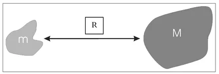
Gravity is a force of mutual attraction between two masses and it will be shown here how this force can be exploited to detect and locate shallowly buried objects. Further discussions of gravitational force require more explanation of what is meant by force, mass, and other quantities, such as density, volume, acceleration, vectors, and scalars. These discussions will be presented throughout this chapter but, for the moment, consider the two masses, m and M, illustrated in Fig. 2.1 separated by a distance R.
Figure 2.1. Geometry used in the definition of gravitational force.
The gravitational force acting between these two masses is the product of the masses mM and varies inversely proportional to the square of their separation R.
A very basic definition of force is a quantity that causes motion or a change in motion. Thus, a gravitational force can induce a motion in either of the two masses. It is impossible to determine if m is stationary and M moves towards m, M is stationary and m moves towards M, or both masses move towards each other. The perception of motion depends on the reference frame from which observations are being made. An intuitive example of this is the perception of motion within a moving train. Stationary objects outside of a moving train appear to be in motion when viewed from within...