![]()
PART 1
Historic context
![]()
1
IN THE BEGINNING
This is another book telling the story of the mine at San Cristobal, in the Department of Potosí, Bolivia. In 2008, the geologist who discovered the mineral deposit, Larry Buchanan, and his wife, Karen Gans, published a memoir about their experiences living in the village of San Cristobal prior to the construction of the mine and their return visits during construction and the initial start-up phase. In 2015, Mariano Baptista Gumucio published an historical panorama, in Spanish, packed with detail after detail up to 2014. Our book is equally panoramic but focuses on the relationships between the communities and the mining company and what can be learned and applied at other mining projects. We apply a variety of social science theories and concepts to understanding the dynamics of the relationships. Above all, we explain how the concept of the social licence to operate was transformed from a metaphor to a practical, measurable management tool during our community relations consulting work at the mine. We start with the historical context of the region and then examine the relations between the company and its stakeholders using, first, a qualitative method, and then a quantitative method. It is both a case study about the challenges of community relations in the extractive industries and a generalisable lesson in community relations techniques.
Early days
Sometime in the second half of the 17th century, rumours began circulating in the community of San Cristobal of a giant silver mine and great riches for the residents. However, the mine and its wealth would arrive long into the future, around the time of the millennium, and come with strings attached (Buchanan and Gans, 2008). The prophecy is retold in the community today, along with many other myths and legends (Consejo Consultivo, 2008) that form part of the collective oral history of the people.
For almost 400 years, the community of San Cristobal was located in a bowl-shaped depression nestled in the hills that rise steeply above the broad expanse of the Bolivian Altiplano 50 kilometres south of the great Salar de Uyuni. The region is a sparsely populated semi desert known as Nor (i.e., ‘North’) Lípez where sources of potable water are few and far between. The open, scrub-covered Altiplano sits between 3,600 and 3,800 metres (more than two miles) above sea level while the knot of hills around San Cristobal rises to 4,500 metres (approaching three miles). It is a place of high thin air, cold nights, and warm sunny days. Rains fall, sometimes as snow, between October and April supporting the seasonal cultivation of food crops – quinoa, potatoes, and other vegetables.
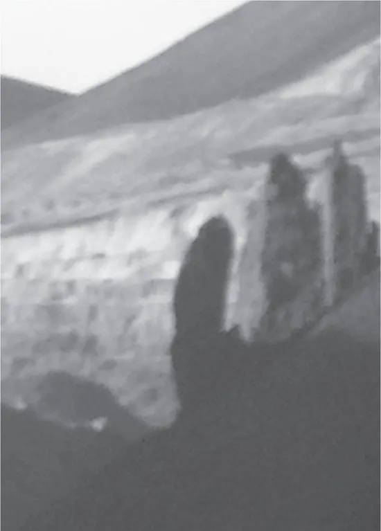
Access to San Cristobal was along a dusty track beside a small stream and through a narrow gorge guarded by three tall rock pillars – Los Tres Gigantes (‘the three giants’, see Figure 1.1). Within the bowl, people and animals were protected from the cold winds and close to a permanent source of water. They were surrounded by relatively fertile hillsides with rocks and caves inhabited by spirits. The population lived in harmony with the seasons and followed a characteristically Bolivian blend of animist beliefs and Catholic Christianity.
There is a distinct lack of documented evidence for the foundation of San Cristobal. However, by combining written records (e.g. Barba, 1640/1817), known dates (construction of the Church in 1620) and the oral history of the community (Consejo Consultivo, 2008), a reasonable sequence of events can be assembled. It seems probable that, around 1605, Spanish explorers led by the Jesuit priest Alonso Barba discovered veins of silver mineralisation within the bowl in the hills close to an existing community known to the residents as Usloque or Osloka (spellings today vary as the name was originally Aymara). This was situated close to a mushroom-shaped rock, venerated by the local people, named Achopalla. A mining camp grew up on the site of the indigenous community, which was renamed by the Spanish; first as San Cristobal de Achocalla (spelling is variable in the historic documents) and soon after, San Cristobal de Lípez (Barba, 1640). Within 15 years a mining community had become fully established around the silver mines with a fine church, richly decorated with murals, paintings, and silver. The small town of several thousand people also functioned as the commercial and administrative centre for the Altiplano south of the Salar de Uyuni, a region the Spanish called Lípez.
In occupying San Cristobal and assuming control of Lípez, the Spanish colonial administration adopted and incorporated the pre-existing traditional form of indigenous community and local government, the ayllu. Ayllus are found among the Quechua and Aymara speaking peoples of Bolivia and Southern Peru. Ayllus were, and remain, since they have survived to the present day in many parts of Bolivia, essentially self-sustaining units of interconnected extended families that owned land and had reciprocal obligations to each other. The responsibilities of membership in the ayllu included communal work for common purposes or work in kind for other members of the ayllu and provision of the mita, a form of tax that provided public goods, such as maintenance of road networks and irrigation and cropping systems that required inter-community coordination of labour. The latter was co-opted by the Spanish to become a tax due to the Crown, and was taken in part as labour, which subsequently became forced servitude in the mines.
The veins of silver ore at San Cristobal, although locally rich, were thin and discontinuous. Furthermore, the most important mine, Hedionda, was plagued with emanations of carbon dioxide rendering the workings hazardous. Many men are reputed to have died of asphyxiation in the mine (Jacobson et al., 1969). Nevertheless, wealth was created from the silver mines which flowed to the Spanish colonists and, somewhat surprisingly, also the indigenous population. The indigenous people across the district of Nor Lípez pooled their wealth under leadership from San Cristobal, and in 1646 purchased the freehold of their traditional lands back from the Spanish Crown (Quisbert Salinas, 2001), relieving them of paying the mita to the colonial administration. The legal acquisition of land title by the ayllus of Nor Lípez is the only known example of the recovery of indigenous lands in Spanish colonial history.
The gift of El Tío
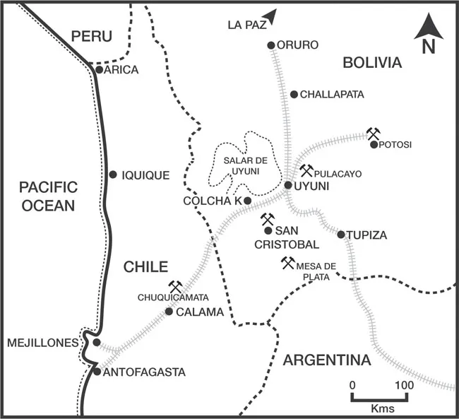
When rich, thick and persistent silver veins were discovered in 1635 at Mesa de Plata (see map in Figure 1.2), a new population centre emerged some distance south of San Cristobal called San Antonio del Nuevo Mundo, close to today’s San Antonio de Lípez. Over the past four centuries, the nearest town and the mining operations there have had various names, including ‘Mesa de Plata’, ‘San Antonio’, ‘San Antonio del Nuevo Mundo’, and ‘San Antonio de Lípez’ (The Diggings, accessed April 17, 2017).
Despite the population draw of Mesa de Plata, San Cristobal retained its place as an administrative centre for the Spanish in Lípez and mining continued at a reduced intensity. It is probably around this time that the prophecy of a giant silver mine at San Cristobal first emerged. There are several versions currently circulating in the community, which share a core of common elements. All feature the role of El Tío.
El Tío (literally, ‘the uncle’) is the spiritual master of the underworld. He is a cross between a pre-Hispanic animistic god and the Christian devil. El Tío is always depicted as a short, hunched man with Caucasian features, a moustache, and a beard. El Tío owns the rocks and minerals, but these are also his gift. Not to use them, to not accept his gift, would be an insult. To the miners, he can be both benevolent and malevolent. A benevolent El Tío can guarantee the miners will find rich ore; a malevolent El Tío will keep the ore hidden and may cause accidents or the death of miners who get on the wrong side of him. Icons of El Tío are found at the entrances to mines throughout Bolivia. The icons are given offerings of alcohol, tobacco, and coca leaves to curry favour and as a form of supernatural accident insurance for mine workers.
The essential elements of the story as it is related today are that El Tío told a shaman from the community that he had hidden a gift that would be revealed to those that still believed in him around the year 2000. El Tío said it would be a gift of silver, the largest and richest in Bolivia, and that it was buried around San Cristobal. He promised that it would bring a new life of wealth to the people. Each of these parts of the prophecy have come to pass.
El Tío also prophesied that there would be so much money the people of San Cristobal would not bother to count their change in the market. The people would live in houses with roofs that shone like silver in the sun. Metal roofs are common in the town of San Cristobal today. The new life would be easy and the people would stop respecting the earth and the gods, including El Tío. People would no longer need to work the land or care for animals. These parts of the prophecy have also come to pass.
However, the prophecy also included a caution: the people would be rich, but they would also be hungry. There would be starvation to the point of cannibalism.
The long wait
Although the mines at San Cristobal continued to operate for many years, the focus of the community shifted to commerce based on the movement of goods and people across the Altiplano. San Cristobal was well placed for this, centrally located in Lípez and on the route between the mines of Potosí and the Pacific coast. It was known as the ‘window on the sea’ welcoming travellers moving between the highlands of Bolivia and the port of Antofagasta, which now belongs to Chile (see bottom left of Figure 1.2). The Spanish also had the need to transport large quantities of supplies from the coast to the mines and take the silver and other metals produced by the mines back to the coast for export to Europe. Horses, mules, and donkeys were imported to function as pack animals, but struggled in the high thin air, had problems reproducing, and suffered severely from the lack of grasses or other suitable forage in the semi desert of the Altiplano. Fortuitously for the Spanish, the dominant indigenous domestic animal of the region, the llama, could be pressed into service as pack carriers.
Llamas are perfectly suited to the role of pack animal. They are relatively easy to train, calm with their owners and handlers, the llameros as they are called, and are comfortable carrying side packs on their backs mounted on a saddle-like harness. Most importantly, they can live off the land feeding on the shrubs, herbs, and occasional grass found on the Altiplano. Llamas are relatively lightly built and the amount they can carry limited to around 30 kg, which has to be carefully balanced to avoid injury to the animal. They can walk steadily for several hours at a pace of 2 to 3 kilometres per hour across the semi desert but need to rest and be relieved of the weight of the pack they are carrying every few days. The llamas also need water to drink. The net result was that the llama trains followed a meandering path across the Altiplano between permanent potable water sites with camps and settlements one day of llama walking apart.
The people of San Cristobal became key members of the chain of communities that organised and operated the llama trains carrying supplies between the mines of Potosí and Lípez and the coastal ports of Iquique and Antofagasta (see Figure 1.2). As llameros, they looked after every aspect of the llamas: breeding, pasturing, training, managing, and leading the pack trains. The movement of goods and supplies by llama train required breaking shipments into many small loads, thus requiring many llamas. Similarly, the need to rest the pack animals meant that any single llama train contained strings of load-bearing animals together with an equal or greater number of animals without loads ready to take over pack-carrying duty. As a result, numerous families and thousands of llamas were deployed in the business of moving materials.
In 1892, transport across the Altiplano was revolutionised by construction of the railway between the port of Antofagasta on the Pacific coast and the city of Potosí (see Figure 1.2). The llameros were almost immediately redundant. The rail line follows the plain well north of San Cristobal but south of the Salar de Uyuni. On Figure 1.2, the Salar, a giant salt flat visible from space, is the area outlined with the dotted line, north of Colcha K. San Cristobal was now both isolated from the transportation network and without a productive economic activity, although still the administrative centre for Nor Lípez. People began to leave looking for better opportunities.
In 1912, the Corregidor for Nor Lípez was elected from Colcha K (Consejo Consultivo, 2008), a community 60 kilometres to the north-west that was starting to be more populous than San Cristobal. He put in motion changes that resulted in the administrative centre moving to Colcha K in 1917. It was at about this time that San Cristobal also lost its resident priest, ending a 300-year tradition of daily mass in the old church.
There was some reactivation of mining through the 20th century. The Toldos mine, located south of San Cristobal, close to Los Tres Gigantes, operated episodically under various owners (Jacobson et al., 1969). The Hedionda mine was rediscovered and brought back into production using innovative methods of air drainage to remove carbon dioxide from the workings (Jacobson et al., 1969). A new discovery at Animas was developed and operated by a co-operative (Jacobson et al., 1969). However, the local population describe these mines as ‘one bad experience after another’. ‘There were very few jobs for us; they brought in people from outside; they did not treat us with respect.’ Both Toldos and Animas ceased operating due to low metal prices in the early to mid-1980s.
Throughout the 20th century, San Cristobal experienced depopulation as families left to find work in the cities of Bolivia or the mines of Chile and Argentina. In 1954, a group of some 20 families moved out and established the community of Culpina K (Consejo Consultivo, 2008, see Figure 1.3). The families chose this location on the edge of the plains, some 17 kilometres due south of San Cristobal, to be close to good llama pastures and cultivatable land and, perhaps more importantly, to be beside the dirt road that now linked the town of Uyuni with Avaroa on the border with Chile.
The same motivations were behind the move in 1980 by a smaller number of families that left San Cristobal to form th...