![]()
Chapter One
Introduction
As a natural resources manager, would you be interested in using aerial photography to reduce costs by up to 35 percent for the mapping, inventorying, and planning involved in the management of forest and rangelands? This was the cost savings estimated by the staff of the Department of Natural Resources, State of Washington (Edwards 1975).
Because of advanced technology and increased availability, this estimate may be low for all natural resources disciplines, as well as for land-use planning (state, urban, and suburban), national defense, law enforcement, transportation route surveys, hydroelectric dams, transmission lines, flood plain control, and the like. With savings of this magnitude, it becomes increasingly important for all agencies, whether county, state, federal, or private, to make maximum use of aerial photography and related imagery.
The study of aerial photography—whether it be photogrammetry or photo interpretation—is a subset of a much larger discipline called remote sensing. A broad definition of remote sensing would encompass the use of many different kinds of remote sensors for the detection of variations in force distributions (compasses and gravity meters), sound distributions (sonar), microwave distributions (radar), light distributions (film and digital cameras) and lidar (laser light). Our eyes and noses are also considered to be remote sensors. These detectors have one thing in common: They all acquire data without making physical contact with the source. A narrower definition of remote sensing, as used in this book, is the identification and study of objects from a remote distance using reflected or emitted electromagnetic energy over different portions of the electromagnetic spectrum.
Photogrammetry is the art or science of obtaining reliable quantitative information (measurements) from aerial photographs (American Society of Photogrammetry 1966). Photo interpretation is the determination of the nature of objects on a photograph and the judgment of their significance. Photo interpretation necessitates an elementary knowledge of photogrammetry. For example, the size of an object is frequently an important consideration in its identification. The end result of photo interpretation is frequently a thematic map, and mapmaking is the primary purpose of photogrammetry. Likewise, photogrammetry involves techniques and knowledge of photo interpretation. For example, the determination of acres of specific vegetation types requires the interpretation of those types. The emphasis of this book is on image interpretation, but it includes enough information on basic photogrammetry to enable one to become a competent photo interpreter. A good interpreter must also have a solid background in his or her area of interest.
Because of the introduction of digital technology into remote sensing, the terminology used throughout this book to distinguish between digital and film-based technology is important. This is because: (1) digital sensors (including cameras) produce images, not photographs; and (2) film sensors produce photographs, but it is also correct to call a photograph an image. Therefore, to clarify our terminology, the following scheme will be used:
Terminology
1. When reference is made to a digital camera, the word digital will always be used.
2. When reference is made to a film camera, film may be used (for emphasis), but in many cases film will not be present.
3. The term photograph will be used only when it is produced by a film camera.
4. The term image will always be used when reference is made to a digital image, but this term may also be used when reference is made to a photograph.
Objectives
After a thorough understanding of this chapter, you will be able to:
1. Write precise definitions to differentiate clearly among the following terms: remote sensing, photogrammetry, and photo interpretation.
2. Fully define the following terms: electromagnetic spectrum, atmospheric window, f-stop, film exposure, depth of field, and fiducial marks.
3. Draw a diagram and write a paragraph to explain fully reflectance, transmittance, absorption, and refraction of light.
4. List the wavelengths (bands) that can be detected by the human eye, film, and terrestrial digital cameras (both visible and photographic infrared bands).
5. Draw complete diagrams of the energy-flow profile (a) from the sun to the sensor located in an aircraft or spacecraft and (b) within the camera.
6. Draw a diagram of a simple frame camera (film or digital), showing the lens shutter, aperture, focal length, and the image captured.
7. Given the first and subsequent photographs taken by a typical, large-format, aerial film camera in the United States, thoroughly explain the meaning of the information printed on the top of most photographs.
8. Given a list of characteristics (or abilities) of various types of cameras discussed in this chapter, state whether each characteristic applies to film cameras only, digital cameras only, or both types of cameras.
9. In a paragraph, briefly discuss the concept of pixel size and the number of pixels associated with digital cameras as related to resolution.
1.1 Electromagnetic Spectrum and Energy Flow
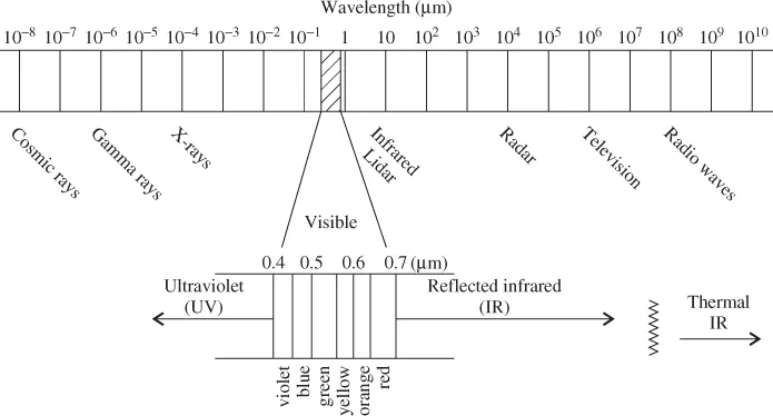
All remote-imaging sensors, including the well-known film cameras and the more recently developed digital cameras, require energy to produce an image. The most common source of energy used to produce an aerial image is the sun. The sun's energy travels in the form of wavelengths at the speed of light, or 186,000 miles (299,000 km) per second, and is known as the electromagnetic spectrum (Figure 1.1). The pathway traveled by the electromagnetic spectrum is the energy-flow profile (Figure 1.8).
1.1.1 The Electromagnetic Spectrum
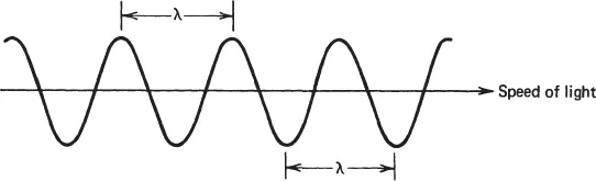
Wavelengths that make up the electromagnetic spectrum can be measured from peak to peak or from trough to trough (Figure 1.2). The preferred unit of measure is the micrometer (mm), which is one-thousandth of a millimeter. The spectrum ranges from cosmic rays (about 10–8 mm), to gamma rays, X-rays, visible light, and microwaves, to radar, television, and standard radio waves (about 108 mm, or 10 km). Different remote sensors are capable of measuring and/or recording different wavelengths. Photographic film is the medium on which this energy is recorded within the film camera and is generally limited to the 0.4 to 0.9 mm region, slightly longer compared to human vision, which can detect from 0.4 to 0.7 mm. The recording medium for digital cameras consists of arrays of solid-state detectors that extend the range of the electromagnetic spectrum even farther, into the near infrared region.
1.1.2 Properties of Electromagnetic Energy
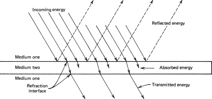
Electromagnetic energy can only be detected when it interacts with matter. We see a ray of light only when it interacts with dust or moisture in the air or when it strikes and is reflected from an object. Electromagnetic energy, which we will call rays, is propagated in a straight line within a single medium. However, if a ray travels from one medium to another that has a different density, it is altered. It may be reflected or absorbed by the second medium or refracted and transmitted through it. In many cases, all four types of interactions take place (Figure 1.3).
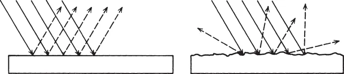
Reflectance.
The ratio of the energy reflected from an object to the energy incident upon the object is reflectance. The manner in which energy is reflected from an object has a great influence on the detection and appearance of the object on film, as well as display and storage mediums for digital sensors. The manner in which electromagnetic energy is reflected is a function of surface roughness.
Specular reflectance takes place when the incident energy strikes a flat, mirrorlike surface, where the incoming and outgoing angles are equal (Figure 1.4, left). Diffuse reflectors are rough relative to the wavelengths and reflect in all directions (Figure 1.4, right). If the reflecting surface irregularities are less than one-quarter of the wavelength, we get specular reflectance from a smooth surface; otherwise, we get diffuse reflectance from a rough surface. Actually, the same surface can produce both diffuse and specular reflection, depending on the wavelengths involved. Most features on the Earth's surface are neither perfectly specular nor perfectly diffuse, but somewhere in between.
Absorptance.
When the rays do not bounce of...