![]()
Part 1
Introduction
1
Regional Geological History: Why and How?
N. H. WOODCOCK1 AND R. A. STRACHAN2
1Department of Earth Sciences, University of Cambridge, Cambridge, UK, and
2School of Earth & Environmental Sciences, University of Portsmouth, Portsmouth, UK
1.1 DEVELOPMENT OF HISTORICAL GEOLOGY IN BRITAIN AND IRELAND
An understanding of the Earth requires a blend of two scientific methods. Causal scientific enquiry attempts to understand the fundamental processes of the Earth, irrespective of their age, typically using the analytical methods of physics, chemistry or biology. The geometrical rules of plate tectonics, the fluid mechanics of sediment transport or the chemical evolution of a magma chamber are all examples of such causal principles. Characteristic of geology, however, is its use of historical analysis, which recognizes that Earth processes depend on their place in geological time. In particular, geological processes may be strongly influenced by preceding events. So, a new plate boundary may preferentially follow an old weakness in the lithosphere, or the chemistry of a magma will be influenced by the compositional history of the source mantle or crust. Thus historical geology can be carried out either on a global scale or, more typically, on a regional scale.
The regional focus of this book, comprising Britain, Ireland and its surrounding crust, has a remarkably varied geology for so small a fragment of continent. This region contains a fine rock record from all the geological periods from Quaternary back to Cambrian, and a less continuous but still impressive catalogue of events back through nearly 2500 million years of Precambrian time. This protracted geological history would be interesting enough to reconstruct if it had been played out in relatively stable continental crust. However, Britain and Ireland have developed at a tectonic crossroads, on crust traversed intermittently by subduction zones and volcanic arcs, continental rifts and mountain belts. The resulting complexity makes the geological history of this region at once fascinating and perplexing.
The coincidence of this complex geology with a scientifically inquisitive human culture was the catalyst for a period of prodigious geological discovery and understanding in the late 18th and early 19th centuries. James Hutton was persuaded, by the unconformities that mark Britain’s major tectonic phases, of both the longevity and cyclicity of geological events. His Theory of the Earth (1795), and its development by John Playfair and Charles Lyell, mark the beginning of modern historical geology. The foundation in London of the world’s first Geological Society (1807) provided a forum in which Britain’s geological history was rapidly pieced together. William Smith soon published his geological map of England and Wales (1815), based on the principles of correlating strata and their fossils, principles that have become modern stratigraphy. The Geological Survey of Great Britain was formed (1835) to produce a more detailed geological map of the country, and a few years later came Richard Griffiths’ geological map of Ireland. At about the same time began the collaboration, and later confrontation, between Roderick Murchison and Adam Sedgwick, which resulted in the establishment of the Cambrian (1835), Silurian (1835) and Devonian (1839) systems and, through Charles Lapworth’s eventual mediation (1879), the Ordovician System.
For a century and a half, therefore, Britain, Ireland and the European countries that host the type areas for Carboniferous and higher systems have provided a reference region for global geological history. This is justification enough to maintain an up-to-date understanding of the regional geological history; but there are other reasons.
1.2 WHY STUDY HISTORICAL GEOLOGY?
The rapid 19th-century growth of historical geology in Britain was partly stimulated by the search for and exploitation of geological resources, mainly metallic minerals and coal. This economic stimulus was revitalized in the 1960s with the exploration for offshore oil and gas resources. Finding petroleum requires an accurate knowledge of the stratigraphy and geometrical structure of a prospective area. However, any programme of exploration and production also needs detailed reconstructions of the geological history of the area, particularly of sedimentary environments and of the diagenetic, thermal and deformation history of the resulting rock sequence. The geological histories that are available for all onshore and most offshore areas of Britain and Ireland provide the essential basis for planning local investigations for geological resources. The results from exploration reveal, in turn, new details or even major modifications to the regional geological history. This modern symbiosis between academic and commercial interests has advanced understanding of the geological history of Britain and Ireland at a rate unprecedented since the 19th century.
Older even than the study of historical geology has been the search for the fundamental causal laws of how Earth works. Hutton and Lyell tried to use specific examples of local or regional geological history to diagnose and illustrate global geological principles. However, despite Lyell’s uniformitarian principle that ‘the present is the key to the past’, our understanding of Earth processes relies heavily on knowledge of their historical context. The atmosphere, oceans, climate, biota, crust and mantle have all evolved through Earth history, so that many of their more complex processes depend on what came before them. A regional geological history, such as that of Britain and Ireland, provides the time frame for understanding the context of process-orientated research. Moreover, the feedback from this research stimulates the refinement of geological histories in the same way as the exploration for economic resources.
There is a third, less tangible, reason for studying regional geological history: the distinctive intellectual challenge and discipline of the study itself. Philosophers of science have struggled to characterize the way that a geologist works and thinks. Having identified physics as the quintessential science, they have typically measured other sciences against its supposed objectivity, predictability and precision. Geology has therefore been viewed merely as a derivative and imprecise form of physics. In practice, geologists rarely work solely by the process of deductive and inductive logic that we call the scientific method. Geology has an essential historical dimension, which distinguishes it from pure physics, chemistry or biology. The geological record is inevitably complex and incomplete, and deciphering it requires an interpretative reasoning similar to that applied to human history. A geological history is charted that best fits the available observations; then it is iteratively improved, revised or rejected as new data become available. Interpretative reasoning is criticized, particularly by pure scientists, for its circularity. However, it has the overriding strength of being the way in which our human understanding of most everyday problems is built up. Geologists are therefore well equipped to solve complex problems that occur at the interface between science and society.
1.3 ARRANGING AND DATING EVENTS: STRATIGRAPHY
How is a regional geological history reconstructed? Sections 1.3–1.6 outline the relevant methodology. This introduction is brief, because a comprehensive introduction would become a textbook of geology in itself. Any history is potentially a synthesis of all available geological information, and no type of evidence is irrelevant. This chapter stresses only general principles, but provides pointers to more detailed topics together with suggestions for further reading.
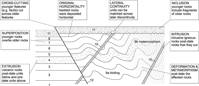
The rock record is made of igneous, sedimentary and metamorphic rocks, with a geometrical arrangement due partly to their original formation and partly to their later deformation. The first step in charting any geological history is to translate this rock geometry into a sequence of geological events through time. This interpretation uses a set of assumptions (Fig. 1.1) sometimes described, perhaps too formally, as the laws of stratigraphy. So, the principle of superposition is that younger rocks in a bedded sequence overlie older rocks, and that of inclusion is that younger rocks may include fragments of older rocks. Cross-cutting relationships are generally such that younger features – typically rock bodies or faults – cut across older features. The assumption of lateral continuity allows units to be matched across intervening faults, intrusions or other interruptions. Igneous rocks are dated by the rule of extrusion – that the age of an extrusive unit in a bedded sequence lies between that of underlying and overlying units – and the rule of intrusion – that intrusive bodies are younger than any country rocks that they cut. The assumption of original horizontality, at least for many sedimentary units, determines that most tilted or folded rocks have been later deformed. The principles of deformation and metamorphism are that these events are younger than the rocks that they affect.
A catalogue of successive geological events can be reconstructed for most regions of the Earth, however complex. More sophisticated stratigraphic subdivision can be achieved in areas dominated by bedded sedimentary or volcanic rocks, and their deformed equivalents. In an example from the Lower Palaeozoic of Cumbria (Fig. 1.2) strata are shown as a graphic log, subdivided into named units. This lithostratigraphic division is based on rock characteristics observable in the field, for instance composition, grain size, colour, primary textures and structures. The basic subdivision is into formations, which are units distinctive enough to be mapped over at least tens of kilometres. Formations are one level in a hierarchy of lithostratigraphic units, each named after a typical geographical locality. So, three of the Cumbrian formations (Fig. 1.2) contain locally mappable, though regionally discontinuous, members. The formations are gathered into two ...