The cryosphere, that region of the world where water is temporarily or permanently frozen, plays a crucial role on our planet. Recent developments in remote sensing techniques, and the acquisition of new data sets, have resulted in significant advances in our understanding of all components of the cryosphere and its processes.
This book, based on contributions from 40 leading experts, offers a comprehensive and authoritative overview of the methods, techniques and recent advances in applications of remote sensing of the cryosphere. Examples of the topics covered include:
• snow extent, depth, grain-size and impurities • surface and subsurface melting • glaciers • accumulation over the Greenland and Antarctica ice sheets • ice thickness and velocities • gravimetric measurements from space • sea, lake and river ice • frozen ground and permafrost • fieldwork activities • recent and future cryosphere-oriented missions and experiments
All figures are in color and provide an excellent visual accompaniment to the technical and scientific aspect of the book.
Readership: Senior undergraduates, Masters and PhD Students, PostDocs and Researchers in cryosphere science and remote sensing.
Remote Sensing of the Cryosphere is the significant first volume in the new Cryosphere Science Series. This new series comprises volumes that are at the cutting edge of new research, or provide focussed interdisciplinary reviews of key aspects of the science.
Trusted by 375,005 students
Access to over 1.5 million titles for a fair monthly price.
The City College of New York, City University of New York, New York, USA
Summary
This introductory first chapter provides a general overview on remote sensing and an introduction to the cryosphere, exposing the reader to general concepts. The chapter is mainly oriented toward those readers with minimal or no experience on either of the two subjects. Remote sensing can be defined as to that ensemble of techniques, tools, data and sensors that allow us to study the Earth and its processes from airborne, spaceborne and in situ sensors without being in physical contact with the object under examination.
In the first part of this chapter, a brief history of remote sensing is introduced, describing early tools and applications (such as the pioneering work from air balloons and cameras attached to pigeons), followed by a basic introduction to the electromagnetic spectrum and electromagnetic radiation. The reader is then presented with a description of remote sensing systems, divided into the categories of passive (aerial photography, electro-optical sensors, thermal systems, microwave radiometers and gravimetric systems) and active systems (LiDAR, radar). Concepts such as spatial, temporal, spectral and radiometric resolutions are also introduced. In the second part of the chapter, the several elements of the cryosphere are introduced, together with a description of their basic physical properties and a general overview of their spatial distribution and the impact on other fields (such as biology, ecology, etc.).
1.1 Introduction
This chapter contains a general overview on both remote sensing and the cryosphere and briefly introduces the reader to their general concepts. Both topics are vast, and it is not possible to cover them in their entirety here. Nevertheless, it is helpful to provide an introductory overview of the two fields, with the references in this chapter (and throughout the book) suggesting reading material for those interested in more details.
1.2 Remote sensing
Remote sensing is the collection of information about an object or phenomenon without physical contact with the object. For practical applications, throughout this book we will refer to remote sensing as that ensemble of techniques, tools, data and sensors that allow us to study the Earth and its processes from airborne, spaceborne and in situ sensors without being in physical contact with the object under examination.
Remote sensing of the Earth began with the development of flight. The first photographs of Paris were taken from air balloons as early as 1858 by Gaspard-Félix Tournachon, a French photographer known as Nadar (http://www.papainternational.org/history.asp). In the 1880s, Arthur Batut attached cameras to kites to collect pictures over Labruguière, France. The apparatus also included an altimeter so that the scale of the images could be estimated. At the beginning of 1900, the Bavarian Pigeon Corps had cameras attached to pigeons, taking pictures every 30 seconds (http://www.sarracenia.com/astronomy/remotesensing/primer0120.html; Jensen, 2006).
Systematic aerial photography began with World War I and was improved during World War II. At the end of the Wars, the development of artificial satellites allowed remote sensing to begin performing measurements on a large scale, leading to the modern remote sensing era. More information on the history of remote sensing can be found, for example, in Jensen (2006).
1.2.1 The electromagnetic spectrum and blackbody radiation
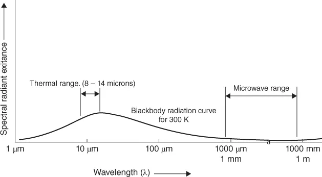
Remote sensing of the Earth is based on the interaction between electromagnetic waves and matter, with the exception of those approaches based on gravimetry. The interaction between materials and electromagnetic waves depends on both the characteristics of the electromagnetic radiation (e.g., frequency) and on the chemical and physical properties of the targets. In many cases, the source of the electromagnetic radiation is the sun, which can be approximated as a black body (an idealized body that absorbs all incident electromagnetic radiation, regardless of frequency) at a temperature of about 5800 K. Though a large number of remote sensing applications deal with the visible portion (400–700 nm) of the electromagnetic spectrum (Figure 1.1), visible light occupies only a fraction of it. Indeed, a considerable portion of the incoming solar radiation is in form of ultraviolet and infrared radiation, and only a small portion is in form of microwave radiation.
Figure 1.1 Spectral regions used for thermal and passive microwave sensing (Adapted from Lillesand et al., 2007).
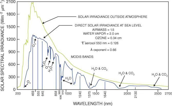
Before reaching a spaceborne or airborne sensor, the electromagnetic radiation propagates through the atmosphere, hence interacting with the different atmospheric components. For example, as the sunlight enters the atmosphere, it interacts with gas molecules, suspended particles and aerosols. Because of the preferential scattering and absorption of particular wavelengths and elements, the radiation reaching the Earth is a combination of direct filtered solar radiation and diffused light scattered from the sky.
As the filtered and diffused solar radiation reaches the Earth, it interacts with surface targets (e.g., soil, snow, vegetation, ocean, etc.). Each of these materials interacts with the electromagnetic radiation through absorption, transmission and scattering, depending on its physical properties (e.g., leaves reflects back most of the radiation in the green regions, water reflects blue radiation more than red and green, etc.). Before reaching the sensors and being recorded by the instruments onboard, the upwelling radiation passes again through the atmosphere.
It follows that the atmospheric components (such as water vapor, carbon dioxide and ozone, Figure 1.2) drive the design of the sensors used to study the Earth from space. On the other hand, in the case of thermal infrared radiation (e.g., 800–1400 nm), the sensors will detect the radiation emitted by the surface as a result of the solar heating. In the case of passive microwave remote sensing, the instruments will record the naturally emitted radiation by the objects, because the incoming solar radiation in the microwave region is negligible.
Figure 1.2 Solar spectral irradiance incident on the top of the atmosphere and transmitted through the atmosphere to the Earth's surface. Major absorption bands in the atmosphere are also shown (NASA).
Features characterizing the data collected by remote sensing platforms are spatial, temporal, spectral and radiometric resolutions. Spatial resolution is a measure of the spatial detail that can be distinguished in an image, being, in turn, a function of the sensor design and its altitude above the surface. Temporal resolution is the frequency of data acquisition (e.g., how many acquisitions are collected within a day) or the temporal interval separating successive data acquisitions. Spectral resolution is the ability of the system to distinguish different parts of the range of measured wavelengths (e.g., the number of measured bands and how narrow each band is).
For recording purposes, the energy received by an individual detector in a sensor must be “quantized” (e.g., divided into a number of discrete levels that are recorded as integer values). Radiometric resolution quantifies the numbe...
Table of contents
Cover
Wiley-Blackwell Cryosphere Science Series
Title Page
Copyright
Dedication
List of contributors
Cryosphere Science: Series Preface
Preface
Acknowledgments
About the companion website
Chapter 1: Remote sensing and the cryosphere
Chapter 2: Electromagnetic properties of components of the cryosphere
Chapter 3: Remote sensing of snow extent
Chapter 4: Remote sensing of snow albedo, grain size, and pollution from space
Chapter 5: Remote sensing of snow depth and snow water equivalent
Chapter 6: Remote sensing of melting snow and ice
Chapter 7: Remote sensing of glaciers
Chapter 8: Remote sensing of accumulation over the Greenland and Antarctic ice sheets
Chapter 9: Remote sensing of ice thickness and surface velocity
Chapter 10: Gravimetry measurements from space
Chapter 11: Remote sensing of sea ice
Chapter 12: Remote sensing of lake and river ice
Chapter 13: Remote sensing of permafrost and frozen ground
Chapter 14: Field measurements for remote sensing of the cryosphere
Chapter 15: Remote sensing missions and the cryosphere
Index
End User License Agreement
Frequently asked questions
Yes, you can cancel anytime from the Subscription tab in your account settings on the Perlego website. Your subscription will stay active until the end of your current billing period. Learn how to cancel your subscription
No, books cannot be downloaded as external files, such as PDFs, for use outside of Perlego. However, you can download books within the Perlego app for offline reading on mobile or tablet. Learn how to download books offline
Perlego offers two plans: Essential and Complete
Essential is ideal for learners and professionals who enjoy exploring a wide range of subjects. Access the Essential Library with 800,000+ trusted titles and best-sellers across business, personal growth, and the humanities. Includes unlimited reading time and Standard Read Aloud voice.
Complete: Perfect for advanced learners and researchers needing full, unrestricted access. Unlock 1.5M+ books across hundreds of subjects, including academic and specialized titles. The Complete Plan also includes advanced features like Premium Read Aloud and Research Assistant.
Both plans are available with monthly, semester, or annual billing cycles.
We are an online textbook subscription service, where you can get access to an entire online library for less than the price of a single book per month. With over 1.5 million books across 990+ topics, we’ve got you covered! Learn about our mission
Look out for the read-aloud symbol on your next book to see if you can listen to it. The read-aloud tool reads text aloud for you, highlighting the text as it is being read. You can pause it, speed it up and slow it down. Learn more about Read Aloud
Yes! You can use the Perlego app on both iOS and Android devices to read anytime, anywhere — even offline. Perfect for commutes or when you’re on the go. Please note we cannot support devices running on iOS 13 and Android 7 or earlier. Learn more about using the app
Yes, you can access Remote Sensing of the Cryosphere by Marco Tedesco in PDF and/or ePUB format, as well as other popular books in Technology & Engineering & Civil Engineering. We have over 1.5 million books available in our catalogue for you to explore.