![]()
PART I
The Periglacial Domain
![]()
1
Introduction
This chapter outlines the periglacial concept and the historical growth of periglacial geomorphology, and its interaction with geocryology, geomorphology, and Quaternary science. The core of periglacial geomorphology concerns the study of freezing processes, the associated ground ice, and related landforms. Permafrost occupies a central, but not dening, position. Periglacial geomorphology is a component of cold-region geomorphology and incorporates a mix of glacial, periglacial, and azonal processes that assume distinct characteristics in the cold non-glacial regions of the world.
Approximately one quarter of the earth’s land surface currently experiences periglacial conditions. During the Pleistocene an additional one fifth was affected to greater or lesser extent.
1.1. THE PERIGLACIAL CONCEPT
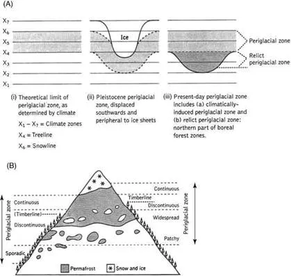
The term “periglacial” was first used by the Polish geologist Walery von Lozinski in the context of the mechanical disintegration of sandstones in the Gorgany Range of the southern Carpathian Mountains, now part of central Romania (Lozinski, 1909, 1912). Subsequently, at the XI Geological Congress in Stockholm in 1910, he introduced the concept of a “periglacial zone” to describe the climatic and geomorphic conditions of areas peripheral to the Pleistocene ice sheets and glaciers. Theoretically, this was a tundra zone that extended as far south as the treeline. In the mountains, it was a zone between timberline and snowline (Figure 1.1).
Almost certainly, Lozinski was influenced by the Swedish geologist J. G. Andersson, who, a few years earlier (1906, pp. 94–97), had summarized his observations on mass-wasting on Bear Island (latitude 74° N), a cold, wet, and windswept island in the North Atlantic. It was Andersson who introduced the term “solifluction” to the scientific literature. He also described the “stone runs,” or quartzite blockfields, that characterize the valley-side slopes of the equally cold and damp Falkland Islands, located in the South Atlantic (Andersson, 1906, pp. 97–101). On hearsay alone, these phenomena had already been compared to the “rubble-drift” and “head” deposits of southern England by James Geikie (1894, pp. 722–723), who attributed the latter to a cold climate “more severe than the present.”
Lozinski referred to his rock-rubble accumulations as periglacial facies. He observed that similar deposits occurred on many of the upland massifs of central Europe. In subsequent years, coarse angular rock-rubble accumulations on upland slopes and summits were widely reported in the scientific literature. Today, they are usually referred to as blockstreams, blockfields, felsenmeer, or kurums.
Two criteria are regarded as diagnostic of periglacial environments. First, there is ground freezing and thawing. According to J. Tricart, “the periglacial morphogenetic milieu is that where the influence of freeze–thaw oscillations is dominant” (Tricart, 1968, p. 830). Second, there is the presence of perennially-frozen ground, or permafrost. According to T. L. Péwé, “permafrost is the common denominator of the periglacial environment, and is practically ubiquitous in the active periglacial zone” (Péwé, 1969, p. 4).
Figure 1.1. Schematic diagram illustrating limits of the periglacial zone: (A) high latitudes; (B) alpine areas.
Periglacial geomorphology developed rapidly in the 1950–1970 period as a sub-discipline of a European-dominated climatic geomorphology (Büdel, 1963, 1977; Tricart, 1950, 1963; Tricart and Cailleux, 1967). During this period, the International Geographical Union (IGU) supported a Periglacial Commission under the leadership of Professor J. Dylik between 1952 and 1972. An international journal, Biuletyn Peryglacjalny, was started in Łódz´, Poland, in 1954.
In hindsight, there were several weaknesses associated with the growth of periglacial geomorphology. First, there was a largely uncritical acceptance of mechanical (frost) weathering and of rapid cold-climate landscape modificiation. Second, the variability, duration, and severity of cold-climate conditions, both today and during the Quaternary, were not fully appreciated. Another concern was that insufficient consideration was given to the influence of lithology in controlling landforms. A final concern related to terminology. Although “cryo” terminology had been proposed earlier to reflect the cold-climate (cryogenic) processes involved (Bryan, 1946, 1949; Capello, 1959), the Pleistocene orientation of periglacial geomorphology led to acceptance of the term “periglacial” (Dylik, 1964a; Dylikowa, 1962; Hamelin, 1964). This raised criticism because the term was used to refer to both processes and areas. The apparent misuse of the term led to the suggestion that it be replaced by more specific terms such as permafrost, ground-ice, or soil-ice environment (Linton, 1969). More recently, cryological terminology has been reintroduced (ACGR, 1988) in order to accommodate a major semantic problem posed by the thermal and physical states of water. The problem appears simple. Unfrozen water can exist in soil or rock at temperatures below 0°C due to the presence of mineral salts, pressure, or other causes. Because of this, “perennially-frozen ground” (i.e. ground at a temperature >0°C, or “cryotic” in nature) may not, in fact, be “frozen”. Thus, cryotic ground can be either “frozen” or “unfrozen” depending upon the amount of unfrozen water present. It follows that not all permafrost is necessarily frozen!
These terminological problems persist today. An obvious example is in the definition of the active layer proposed by the ACGR (1988). Traditionally, the active layer was defined as the near-surface layer above permafrost which thaws during summer (see Chapter 5). The ACGR definition would include the uppermost part of permafrost in those situations where either salinity or clay content allows permafrost to thaw and refreeze annually, even though the material remains cryotic (below 0°C). Under this definition, it is argued that the active layer cannot be determined consistently in time and space (Burn, 1998b) and the term is impossible to use effectively in the field. A partial solution has been to recognize a “transient layer” at the top of permafrost and at the base of the active layer (Shur et al., 2005). The active layer and the transient layer are discussed in detail in Chapter 5.
Today, the utility of the periglacial concept requires careful assessment. Lozinski referred to a specific and limiting environment that is not typical of the vast majority of periglacial environments today. In fact, few, if any, modern-day analogues can be identified (French, 2000). Lozinski also used the term to refer primarily to areas or regions. However, one may argue that typical “periglacial regions” do not exist, and, if they do, lack well-defined boundaries. Thus, André (1999) explicitly questions the effectiveness of freeze–thaw in fashioning the periglacial landscape and refers to the “smokescreen of the periglacial scenery.” In a similar vein, French and Thorn (2006) suggest that periglacial areas are cold-climate “zones” in which seasonal and perennial frost, snow, and normal azonal processes are present to greater or lesser degree. The reality is that many periglacial landscapes inherit the imprint, in varying degrees, of either glacial or non-cold-climate conditions.
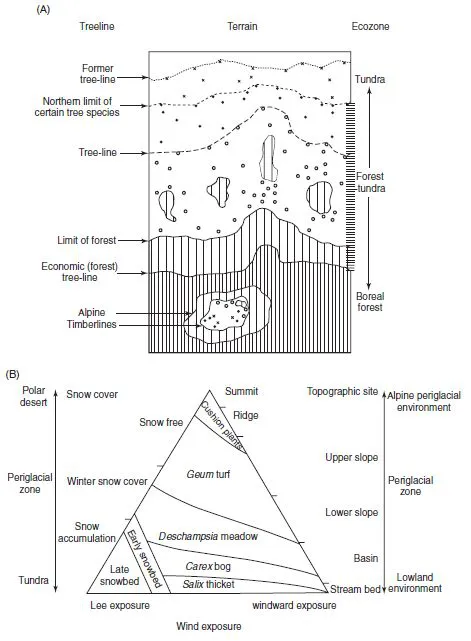
A further complication is that so-called “periglacial” conditions often extend south of the latitudinal treeline and below the altitudinal timberline (Figure 1.2). This is because many areas of northern boreal forest are underlain by relict permafrost and, in alpine regions, glaciers may extend below timberline and into the forest zone. Finally, the treeline is a zone rather than a line and may extend over a latitudinal distance of ∼100–150 km.
To summarize, therefore, modern usage of the term “periglacial” refers to a range of cold, non-glacial processes. We can define periglacial geomorphology as the sub-discipline of geomorphology concerned with cold non-glacial landforms. Because permafrost is a central, but not defining, element, much of the core of periglacial geomorphology is also a component of geocryology. However, periglacial geomorphology also includes the impact of seasonal freezing and the roles of seasonal snow, and of ice of a uvial, lacustrine, and marine nature. Finally, periglacial geomorphology must embrace the azonal processes such as running water, wind, and waves that exhibit distinct characteristics in cold-climate environments.
Figure 1.2. Relationship between the periglacial zone, the treeline and the timberline. (A) Forest limits and tree-lines according to Hustich (1966). (B) The plant type distribution, from tundra to polar desert, and from lowland to alpine (upland) environments, according to Billings and Mooney (1968).
1.2. DISCIPLINARY CONSIDERATIONS
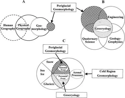
Periglacial geomorphology currently maintains a bridging position between geomorphology, geocryology, and Quaternary science. Here, the disciplinary overlaps are considered. They are illustrated schematically in Figure 1.3.
1.2.1. The Growth of Geocryology
Geocryology, or permafrost science, is one of the cryospheric sciences. Clearly, the cryolithosphere (i.e. perennially and seasonally cryotic – that is, below 0°C, – ground) is central, and the cryohydrosphere (i.e. snow cover, glaciers, and river, lake, and sea ice) less central, to periglacial geomorphology.
For several reasons, the relations between geocryology and periglacial geomorphology are complex. First, for many years, permafrost studies were conducted in North America and the former Soviet Union (Russia) not only in relative isolation to each other but also in isolation from mainstream (geographical) geomorphology. Second, Russian and Chinese geocryology adopt holistic all-encompassing approaches whereas North American permafrost studies are characterized as being either “science” or “engineering” in nature. Thus, there is no North American text that equals the breadth and depth presented by the most recent Russian and Chinese texts, General Geocryology (Yershov, 1990) and Geocryology in China (Zhou Youwu et al., 2000). Third, permafrost studies sit awkwardly between the disciplines of geography and geology. For example, in North America and much of Europe, periglacial geomorphology is taught usually in geography departments while permafrost is within geology, geophysics, or earth science departments. Similar fractionation occurs in Russia and China.
Figure 1.3. Diagram illustrating the disciplinary interactions and overlap of periglacial geomorphology. (A) The relations between physical geography, geomorphology, and periglacial geomorphology. (B) The relation between periglacial geomorphology and geocryology and the interactions of these disciplines with Quaternary science and other natural sciences. (C) Periglacial geomorphology and its overlap with the cryospheric sciences. Note: all the disciplinary boundaries are porous and those marked by broken lines are particularly so.
The most obvious areas of overlap between periglacial geomorphology and geocryology lie in the problems associated with ground freezing and the occurrence of ground ice.
1.2.2. The Changing Nature of Quaternary Science
Advances in Quaternary science, and in particular the expansion and proliferation of sophisticated dating techniques, mean that studies involving paleo-environmental reconstruction no longer rely solely upon the morphological and stratigraphical evidence (Büdel, 1951, 1953; Poser 1948; Smith, 1949) that was typically used in traditional Pleistocene periglacial studies. Instead, a broader range of evidence now includes biological phenomena such as fauna and ora, arboreal and non-arboreal pollen, temperature-sensitive insects such as beetles (coleoptera sp.), and geochemical indicators such as isotopes. Stratigraphy is increasingly being supplemented by the study of ground ice, or cryostratigraphy. Thaw unconformities, truncated ice bodies, and cryostructures are now used to infer previous freezing and thawing events or early Holocene climate change (Burn, 1997; French, 1999; Melnikov and Spesivtsev, 2000). One must conclude that much of traditional Pleistocene periglacial geomorphology has been largely replaced by cryostratigraphy and cryolithology.
1.2.3. Modern Periglacial Geomorphology
As noted by M. Church (2005), geomorphology is no longer the preserve of geographers and geologists. However, periglacial geomorphology continues to be identified as a process sub-discipline of geomorphology that is distinct from both geocryology and Quaternary science. The key processes are those associated with seasonal and perennial frost.
While geocryologists concentrate upon the thermal implications of terrain and the presence of ice within the ground, periglacial geomorphologists emphasize the associated landforms, and their growth and modification through time. Obviously, there is considerable overlap between the two. For example, the recognition of anti-syngenetic wedges on hillslopes (Mackay, 1990a, 1995b) is an illustration of the overlap between landscape evolution (geomorphology) and permafrost-related processes (geocryology). Likewise, as discussed above, there is a complex overlap between periglacial geomorphology and Quaternary science via cryostratigraphy and cryolithology.
Permafrost cannot be the only diagnostic criterion for periglacial geomorphology. This is because permafrost is a thermal concept while geomorphology is concerned with land-forms that are not controlled by ground temperature alone. On the other hand, permafrost and ground ice must be central to periglacial geomorphology in the same way that hillslopes and running water are central to geomorphology at large.
It is easy to forget that the broad features of cold-climate terrain are largely influenced by lithological variability, the nature and distribution of ice contained within bedrock or surficial materials, and the enhanced action of azonal processes. The earlier editions of this text, like that of A. L. Washburn (1979), gave insuffcient attention to the geological control over periglacial landscapes.
1.3. THE GROWTH OF PERIGLACIAL KNOWLEDGE
Even before Lozinski proposed his periglacial concept, a scattered body of geomorphic knowledge was available concerning the cold non-glacial regions of the world.
As might be expected, many of the earliest observations were by the European explorers of the vast sub-arctic regions of North America and Eurasia. These were casual, opportunistic, and non-scientific. For example, in Russian Alaska, the peculiarities of frozen ground were observed in 1816 by members of the Otto von Kotzebue expedition (von Kotzebue, 1821) as they traveled through the Bering Strait region (Figure 1.4). The presence of massive bodies of ground ice, portrayed in Figure 1.4, was to subsequently become a major component of periglacial study in the latter part of the twentieth century. Elsewhere in Russia, Karl Ernst von Baer, an Estonian–German naturalist who had traveled to Novaya Zemblya and Lapland in 1837, was the first to report (Baer, 1838) upon the excavation of a well in perennially-frozen ground at Yakutsk, central Siberia. Subsequently, Alexander von Middendorf, Karl Baer’s younger traveling companion from his expedition to Lapland, descended the shaft, known today as Shergin’s Well. The temperatures that he measured (Middendorf, 1862) are the earliest published information on the thermal regime of what is now termed permafrost. Middendorf correctly interpreted the ground temperature variations with depth and recognized what is now referred to as the “depth of zero-annual amplitude.”
In North America, the eighteenth-century employees of the Hudson Bay Company occasionally made observations related to the terrain over which they traveled. Then, in 1839, Dr John Richardson, the physician who accompanied the explorer John Franklin on his expeditions of 1819–22 and 1825–27, presented observations upon frozen ground in North America (Richardson, 1839, 1841). Later, he sketched one of the distinctive pingos of the Mackenzie Delta region, known locally today as Aklisuktuk (“the little one that is growing”) (Richardson, 1851, p. 234; see Mackay, 1981c). Following upon the disappearance of John Franklin’s 1848–49 expedition to the Arctic and the numerous Franklin searches and other exped...