- English
- ePUB (mobile friendly)
- Available on iOS & Android
eBook - ePub
The Mapping of Geological Structures
About this book
Detailed mapping and analysis of the structural features of rocks enable the 3D geometry of their structures to be reconstructed. The resulting evidence of the stresses and movement patterns which rocks have undergone indicates the processes by which they were formed, and allows evaluation of past deformations of the earth's crust. Written to show how one actually describes, measures and records rock structures such as folds and faults with the emphasis on accuracy, detail and on-going interpretation throughout, this handbook gives students and enthusiasts the practical information and guidance which allows their fieldwork to become vastly more rewarding.
"...the author is to be congratulated on producing such an excellent text. The whole range of mapping techniques that an undergraduate student will require are described and the book will still be immense help to post-graduates setting out on their research work. The book represents extremely good value and is thoroughly recommended."
--C.R.L. Friend, Mineralogical Magazine
Tools to learn more effectively

Saving Books

Keyword Search

Annotating Text

Listen to it instead
Information
1
Introduction
1.1 Objectives
This book is designed as a basic guide to the field mapping and interpretation of geological structures. Emphasis is placed upon the identification of structures and the systematic recording of structural data, as both should be a fundamental part of any mapping programme. The identification and description of structures, together with an understanding of their development, i.e. their movement patterns (Kinematic analysis) and an appreciation of the forces and stresses responsible for them (Dynamic analysis) are extremely useful for interpreting particular structures, and for knowing what geometry to expect whilst mapping in a particular terrane.
Structural data cannot be recorded or used in a vacuum. They must be accompanied by full lithological, sedimentological, petrological and palaeontological descriptions for their complete interpretation.
The following aspects are emphasised in this Handbook;
1 Recognition of structures.
2 What to measure and what to describe.
3 How to analyse the data collected.
4 How to interpret the data and incorporate it into the stratigraphy, interpretation and regional syntheses for an area.
In all cases emphasis is placed upon systematic field observations, accurate measurements of the orientations of structural elements, careful recording of the data in the field notebook, sketching and photographing the structures, and analysis in the field using the stereographic projection. Above all, structural geology requires the appreciation of the three-dimensional nature of structures. Think in 3D and learn to extend your view of structures above and below the map sheet.
1.2 Fieldwork
The importance of careful, accurate and systematic fieldwork cannot be overemphasised. Basic geologic mapping techniques are described in Barnes (1981), and the field descriptions of sedimentary, metamorphic and igneous rocks are outlined in the companion Handbooks by Tucker (1982), Fry (1984), and Thorpe and Brown (1985) respectively.
This Handbook describes the field techniques for mapping geological structures and for the identification and mapping of particular types of structure. It also gives a brief summary of the interpretation and analysis of structures.
Remember the following points:
1 Accurate measurement, observation and recording of all structural elements is essential. Avoid data selection in the field, otherwise you may find that upon further interpretation in the laboratory, you have failed to measure a key structural feature.
2 Carry out an ongoing interpretation whilst in the field (draw sketch cross-sections and maps). This will help you recognise key areas where further work may be necessary. Your interpretation will be governed by your experience and knowledge of regional structure, but only accurate and well-recorded data will have a permanent value and permit continuous reinterpretation.
3 Data should always be plotted on maps and cross-sections whilst in the field. Only in these circumstances can an effective, ongoing interpretation be achieved.
4 Structural data must be collected in conjunction with other lithological, petrological and palaeontological data.
Conduct and safety in the field
Fieldwork frequently puts geologists in hazardous situations. Structural geologists commonly work in rugged and exposed terrain where 3D exposure is good. Be safety conscious and aware of the possible dangers, particularly from loose rock underfoot, and from rock falls. Barnes (1981) outlines fieldwork safety, and in addition to reading this the reader should also consult the safety checklist on p. 16 of this Handbook before commencing fieldwork. Always carry out fieldwork in compliance with the Geologists’ Association Code of Conduct (see Barnes, 1981).
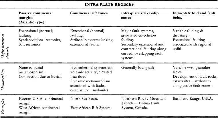
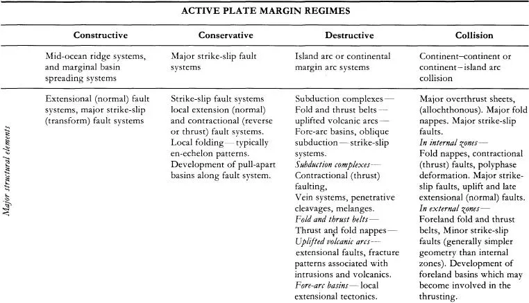
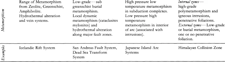
1.3 Tectonic and structural regimes
It is beyond the scope of this Handbook to describe regional structural relationships in detail, but it is useful to identify the dominant features associated with particular tectonic settings, as they provide a useful guide to the structures that may be found whilst mapping (Table 1.1). Characteristic families of structures may be expected to occur in a particular environment, e.g. shallow thrust faults and parallel folding in frontal regions of foreland fold and thrust belts, and this knowledge can greatly aid any ongoing interpretation. Table 1.1 is neither exhaustive nor exclusive in its contents and you should always be prepared for other structures to occur and record all the structural information from the outcrops in your mapping area.
Table 1.1 Structures associated with particular tectonic regimes.
1.4 Bedding
In sedimentary and many metamorphic rocks, bedding surfaces (surfaces of primary accumulation) are our principal reference frame (or datum). There are many possible bedforms in sedimentary sequences (see Tucker, 1982 for details) and the structural geologist must be aware that significant departures from layer-parallel stratigraphy can occur in certain sedimentary environments, e.g. deltas; thus structural data must always be collected in conjunction with sedimentological and stratigraphic data.
Bedding is one of the most important structural elements and the structural data that should be collected for bedding are outlined in Table 1.2. The spatial distribution of bedding or compositional banding (e.g. ingneissic terranes), will define the major fold and fault structures within your mapping area.
1.4.1 Way-up/younging and facing
Way-up/younging is the direction in which stratigraphically younger beds/units are found. (The term tops is also sometimes used in this context.)
The stratigraphic way-up is of fundamental importance in determining the structure of an area. It is based upon a knowledge of stratigraphy and of small-scale sedimentary structures which indicate the stratigraphic way-up and the sequence of deposition. Sedimentary structures which indicate way-up are discussed in Tucker, 1982 and are summarised in Fig. 1.1. Always look for and record way-up features when mapping.
The structural way-up refers to the bedding/cleavage relationships that indicate the position within a major fold structure (e.g. on the overturned limb of a recumbent fold). This may have no relationship to stratigraphic way-up. Take care to distinguish the two — see Chapter 3 for greater detail.
Facing is the direction within a structure i.e. along the fold axial plane or cleavage plane, in which younger beds/units are found. This term is generally applied to folds, or cleavage relationships.
1.5 ‘Synsedimentary’ versus tectonic structures
In many areas of deformed sedimentary rocks it is difficult to distinguish between structures formed during deposition or early diagenesis when the sediment was unconsolidated, and those formed after lithification in response to tectonic forces. On cursory examination many ‘synsedimentary’ structures such as slump folds have superficial geometric similarities to ‘tectonic’ folds (Fig. 1.2a). Syndepositional faults are also common (Fig. 1.2b) and in some instances syndepositional cleavage fabrics have been observed (Fig. 1.2c). It is the...
Table of contents
- Cover
- Contents
- Title Page
- Map Symbols
- Copyright
- Acknowledgements
- 1 Introduction
- 2 Mapping techniques
- 3 Fold structures
- 4 Foliations
- 5 Linear structures
- 6 Faults and shear zones
- 7 Joints, veins and stylolites
- 8 Polyphase deformation
- 9 First steps in overall
- References and further reading
- Appendix I Real and apparent dip nomogram
- Appendix II Thickness exaggeration with apparent dip
- Appendix III Strain measurements
Frequently asked questions
Yes, you can cancel anytime from the Subscription tab in your account settings on the Perlego website. Your subscription will stay active until the end of your current billing period. Learn how to cancel your subscription
No, books cannot be downloaded as external files, such as PDFs, for use outside of Perlego. However, you can download books within the Perlego app for offline reading on mobile or tablet. Learn how to download books offline
Perlego offers two plans: Essential and Complete
- Essential is ideal for learners and professionals who enjoy exploring a wide range of subjects. Access the Essential Library with 800,000+ trusted titles and best-sellers across business, personal growth, and the humanities. Includes unlimited reading time and Standard Read Aloud voice.
- Complete: Perfect for advanced learners and researchers needing full, unrestricted access. Unlock 1.4M+ books across hundreds of subjects, including academic and specialized titles. The Complete Plan also includes advanced features like Premium Read Aloud and Research Assistant.
We are an online textbook subscription service, where you can get access to an entire online library for less than the price of a single book per month. With over 1 million books across 990+ topics, we’ve got you covered! Learn about our mission
Look out for the read-aloud symbol on your next book to see if you can listen to it. The read-aloud tool reads text aloud for you, highlighting the text as it is being read. You can pause it, speed it up and slow it down. Learn more about Read Aloud
Yes! You can use the Perlego app on both iOS and Android devices to read anytime, anywhere — even offline. Perfect for commutes or when you’re on the go.
Please note we cannot support devices running on iOS 13 and Android 7 or earlier. Learn more about using the app
Please note we cannot support devices running on iOS 13 and Android 7 or earlier. Learn more about using the app
Yes, you can access The Mapping of Geological Structures by K. R. McClay in PDF and/or ePUB format, as well as other popular books in Physical Sciences & Geology & Earth Sciences. We have over one million books available in our catalogue for you to explore.