![]()
1: Introduction
1.1 WHAT IS GLACIAL GEOLOGY AND WHY IS IT IMPORTANT?
Glacial geology is the study of the landforms and sediments created by ice sheets and glaciers, both past and present. Within Earth history, ice sheets and glaciers have grown and decayed many times, making them a key part of the Earth’s environmental system (Box 1.1). The present landscape in many mid-latitude areas is a function of the ice sheets and glaciers that grew and decayed during the Cenozoic Ice Age. During the Cenozoic – the past 65 million years – the Earth’s climate has changed dramatically. The Antarctic Ice Sheet developed, followed by ice sheets in Greenland and elsewhere in the Arctic north. Later, large mid-latitude ice sheets developed in North America, Scandinavia, Europe, New Zealand and Patagonia. These ice sheets dramatically changed the landscape beneath them and have left a record of their presence in the form of glacial landforms and sediments. This record shows that these ice sheets are not only a consequence of oscillations in global climate, which has driven their growth and decay with amazing regularity during the past two million years, but that they have also helped to drive climate change by modifying and interacting with the atmosphere. Understanding these ice sheets and glaciers is vital if we are to understand the mechanisms of global climate change.
BOX 1.1: HISTORY OF ICE ON EARTH
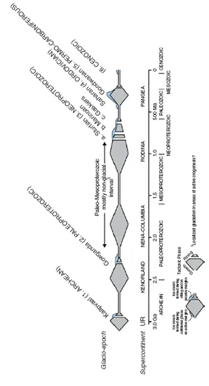
Ice has been part of the Earth’s environmental system at several points throughout its 4.6 billion year history, and the passage of ancient ice sheets is recorded predominantly by glaciomarine sediments deposited and preserved in a variety of geological basins (Eyles, 2008). Much of this record can be interpreted by using our present understanding of glacial processes and products to interpret the past. In essence this is the application of the fundamental geological principle of uniformitarianism – the present is the key to the past. However, the Earth’s Neoproterozoic glacial record challenges this idea. During the late 1990s the ‘snowball Earth’ concept emerged (Hoffman and Schrag, 2002). The ‘snowball Earth’ hypothesis envisages a series of cataclysmic global glaciations in which glacial ice reached tropical latitudes and the Earth’s hydrological system almost completely shut down. The glacial processes involved in this global freeze would have been very different from those of the Cenozoic Ice Age. This hypothesis has become the source of considerable controversy over recent years and a number of alternative ideas have been advanced to explain the presence of glacial sediments at low latitudes at this time. One of these hypotheses, the Zipper Rift model, is based on the idea of adiabatic or uplift-driven glaciation associated with the progressive rifting of the Rodinia super continent. The debate surrounding ‘snowball Earth’ continues to generate controversy as geologists attempt to decipher the record contained within the glacial rocks of the Neoproterozoic. The key to these debates lies in our ability to read the clues within these ancient glacial records and, in particular, in a rigorous understanding of contemporary glacial processes and products.
Sources: Eyles, N. (2008) Glacio-epochs and the supercontinental cycle after 3.0 Ga: tectonic boundary conditions for glaciation. Palaeogeography, Palaeoclimatology, Palaeoecology, 258, 89–129. Hoffman, P.F. and Schrag., D.P. (2002) The Snowball Earth hypothesis: testing the limits of global change. Terra Nova, 14, 129–55. Reproduced with permission from: Eyles, N. (2008) Palaeogeography, Palaeoclimatology, Palaeoecology, 258, figure 1, p. 9].
BOX 1.2: CENOZOIC GLACIAL SEDIMENTS: AN ENGINEERING LEGACY
During the Cenozoic Ice Age approximately 30% of the Earth’s land surface was glaciated and as a consequence over 10% of our land is now covered by glacial sediments – tills, silts, sands and gravels. In a country such as Britain this proportion is even higher. Any form of construction on or in these sediments must consider their engineering properties. At what angle will the sediment stand if excavated? How will they respond when loaded? How variable are they? How permeable are they? These questions can be answered only by a detailed knowledge of the sediments and of the processes that deposited them: the contribution of the glacial geologist.
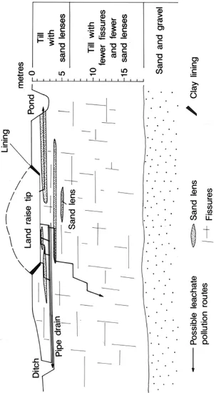
A good example is provided by a proposed development at Hardwick Air Field in Norfolk. In 1991 Norfolk County Council applied for planning permission to build a waste hill (land raise) 10 m high to dispose of 1.5 million m3 of domestic waste over 20 years. Crucial to their proposal was the assertion that the area was underlain by glacial till, rich in clay, which would act as a natural impermeable barrier to the poisonous fluids (leachate) generated within the decomposing waste. Normally an expensive containment liner is required to prevent contamination of the ground water by the leachate. This proposal became the subject of local debate and as a consequence the planning application was called to public planning enquiry in 1993. At this enquiry the objectors used a detailed knowledge of glacial till to argue that it was inadequate as an impermeable barrier in its natural state. Till contains fissures and pockets of sand through which the leachate may pass. The proposal was rejected, partly on the basis of this evidence. This example illustrates how knowledge of glacial sediments is vital to making engineering decisions within glaciated terrains.
Source: Gray, J.M. (1993) Quaternary geology and waste disposal in South Norfolk, England. Quaternary Science Reviews, 12, 899–912. [Modified from: Gray, J.M. (1993) Quaternary Science Reviews, 12, figure 9, p. 905].
In many parts of the world a distinct landscape composed of many different landforms and sediments was created by the glaciers of the Cenozoic Ice Age. This glacial landscape still survives today. It determines the distribution of valuable resources such as aggregates, and the way in which we build roads, railways, factories and houses (Box 1.2). The aesthetic appeal of this glacial landscape, to be found in many upland areas of North America and Europe, for example, is also the product of these glaciers. The spectacular mountain scenery is the result of glacial erosion, whereas glacial deposition often produces a gently rolling landscape. If we are to understand the form and texture of this glacial landscape we must understand the glaciers that produced it.
The landforms and sediments left by these glaciers are the clues from which they can be reconstructed and their behaviour studied. This subject, palaeoglaciology, is of increasing importance as we seek to understand how the glacial system interacts with other parts of the Earth’s global system. By studying glacial landscapes and reconstructing the glaciers that created them we can examine the way in which glaciers grow, decay and interact with climate. From such research we can begin to predict what will happen when the mid-latitude ice sheets next return because, although the present is optimistically termed the Postglacial, there is no reason to suppose that large glaciers or ice sheets will not return to the mid-latitudes in the future.
1.2 THE AIM AND STRUCTURE OF THIS BOOK
Glaciers are the scribes of the Cenozoic Ice Age and they have etched its story upon the landscape. It is a story that has been written repeatedly upon the same page with the successive growth and decay of each glacier. Each glacier has destroyed, remoulded or buried the evidence of earlier phases of glaciation. Deciphering the story of this complex geological record is therefore difficult and requires careful detective work. The landforms and sediments left by former glaciers provide the clues from which to reconstruct their form, mechanics and history. This book shows you how to interpret these clues.
We start first by looking at contemporary glacial environments around the world in order to illustrate the diversity of the glacial systems that exist today. This is followed by two chapters that introduce the basic mechanics of the glacial system to provide an understanding of how glaciers work. We explain how ice sheets and glaciers grow, flow and decay. In Chapters 5 and 6 we explore the processes of glacial erosion and consider the landforms that they create; landforms which can be seen in the landscape today and which provide information about the dynamics of the glaciers that created them. In Chapters 7–11 we tackle the processes of glacial sedimentation and landform development, all of which provide important evidence of glacier activity. The final chapter examines how we can use the clues in the landscape to reconstruct ancient glacial systems – the study of palaeoglaciology. Important terms in the text are highlighted in italics either when they are first used or when they are particularly pertinent to the subject being considered. Some terms therefore will appear in italics more than once.
![]()
2: Glaciations Around The Globe
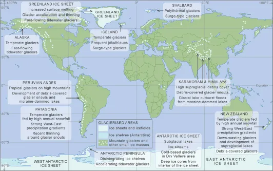
The aim of this chapter is to illustrate, via series of case studies, the range and diversity of styles of glaciation on Earth today, while also drawing attention to some of the contemporary debates within the discipline that are focused on these different regions (Figure 2.1). Those readers without any knowledge of glacial processes may choose to skip this chapter and return to it later. The first two case studies describe the contemporary polar ice sheets, and cover: (i) the recent changes in the glaciers and ice shelves around the Antarctic Ice Sheet; and (ii) the complex relationship between changes in outlet glacier discharge and climate on the Greenland Ice Sheet. The remaining five case studies are concerned with the styles of glaciation in contrasting glaciological settings, and include: (i) southern hemisphere temperate glaciers in Patagonia and New Zealand; (ii) northern hemisphere temperate glaciers in Alaska and Iceland; (iii) high-altitude glaciers in the Himalaya; (iv) tropical glaciers in the Cordillera Blanca, Peru; and (v) polythermal glaciers in the Arctic.
2.1 THE ANTARCTIC ICE SHEET
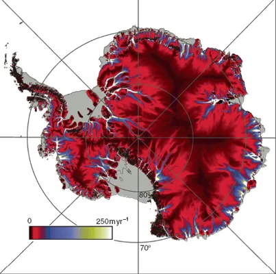
The Antarctic Ice Sheet, covering 98% of the continent, is the largest ice sheet on Earth. The ice sheet averages ~1.6 km thick, but it is over 4 km thick where it overlies deep subglacial basins. It is divided in two by the Transantarctic Mountains, with the smaller West Antarctic Ice Sheet on one side and the larger East Antarctic Ice Sheet on the other. The continent contains about 90% of the world’s glacier ice, which equates to about 70% of the entire world’s fresh water. If the ice sheet melted, sea levels would rise globally by about 60 m. In most of the interior of the continent precipitation is very low, often as little as 20 mm per year, although precipitation rates rise towards the coast, where the air contains more moisture. Of the two components of the ice sheet, the West Antarctic Ice Sheet has received most scientific attention because of the possibility that it could collapse, or disintegrate rapidly. The reason for this potential instability stems from the fact that the ice sheet overlies a basin with a mean elevation below contemporary sea level. If the West Antarctic Ice Sheet were to collapse, global sea levels could rise by up to 6 m in a matter of centuries. As a whole the Antarctic Ice Sheet is a complex system, but we can identify six main components.
1. A high-elevation plateau or ‘Polar plateau’. Here there is little moisture and so snow accumulates very slowly such that it is measured in millimetres to centimetres per year. It has been suggested that peripheral thinning of the ice sheet, which has been observed recently, is balanced by interior thickening on the Polar plateau, but the absence of detailed mass balance studies of the ice sheet makes this difficult to establish with any degree of certainty. As a result, we do not know if the ice sheet is in negative or positive mass balance (see Section 3.1). The longest continuous deep ice cores have been drilled on the Polar plateau, providing information about the climatic and atmospheric records in Antarctica over eight glacial cycles spanning the past 740 000 years.
2. Peripheral ice streams. These ice streams are key components of the glacial system because they discharge the majority of the ice and sediment associated with the Antarctic Ice Sheet; for example, ice streams account for over 90% of the overall discharge from the ice sheet (Figure 2.2). Ice streams are narrow corridors of fast flowing ice with velocities in the range of 0.5–1 km per year, over two orders of magnitude faster than adjacent ice. Consequently, ice streams are typically heavily crevassed, with abrupt lateral margins (shear margins) between the ice streams and surrounding ice. The variables that control the location, dynamics and behaviour of these ice streams are uncertain, but in some cases they appear to overlie sedimentary basins of soft-sediment that may deform beneath the ice thereby assisting forward flow (see Section 3.3). To add to this complexity it is now known that ice streams can switch on or switch off through time. For example, the Kamb Ice Stream, formerly known as Ice Stream C, in West Antarctica switched off around 150 years ago and has been stagnant ever since.
3. Fringing ice shelves. These are the floating continuation of outlet glaciers and surround nearly half of the Antarctic continent. Some of these ice shelves are very large, such as the Ross Ice Shelf, which is about the same area as France. Ice shelves perform a vital role in influencing the dynamics, and therefore the system response time, of upstream ice from inland Antarctica because they hold back or buttress ice flow from the glaciers or ice streams that feed them (Box 2.1). Calving of icebergs from ice-shelf termini accounts for approximately 90% of Antarctic ice loss. There is also rapid heat exchange between the ice shelves and the ocean beneath, meaning that they add considerable quantities of fresh water to the oceans. Finally, ice shelves are capable of entraining, transporting and depositing large quantities of glacial sediment (Figure 2.3) and dispersing it more widely as calved icebergs drift out to sea.
BOX 2.1: ANTARCTIC PENINSULA ICE SHELVES: BREAKING UP IS ALL TOO EASY
Some of the most dramatic recent changes in Antarctica have taken place on the Antarctic Peninsula, the northernmost part of the continent that projects towards South America. As a direct result of temperature rise in the past 50 years or so, ice shelves on the Antarctic Peninsula have been slowly receding. Most of the ice shelves have shown two phases of recession; a climatically driven progressive recession over decades, and a more rapid ice-shelf collapse phase. Probably the most famous event was the sudden collapse over 6 weeks (February-March 2002) of the Larsen B Ice Shelf, which disintegrated with the loss of 3200 km2 of ice shelf. The recent mass loss from glaciers formerly feeding the ice shelves of the Antarctic Peninsula is estimated to be sufficient to raise eustatic sea level by between 0.1 and 0.16 ± 0.06 mm yr-1.
The 2002 Larsen B Ice Shelf collapse has been studied intensively using a number of methods. The key features of the ice-shelf collapse are:
1. Prior to its 2002 collapse, the Larsen B Ice Shelf had been in existence throughout the entire Holocene (the past 10 000 years). The presence or absence of ice shelves can be detected in the sediments around the ice shelves using ocean cores (Domack et al., 2005).
2. Before it collapsed the ice shelf was fed by a number of individual tributary glaciers originating from the mountains of the Antarctic Peninsula...