![]()
PART I
Tectonic processes as driving mechanisms for palaeogeographical and palaeoenvironmental evolution in Amazonia
![]()
TWO
Geological evolution of the Amazonian Craton
Salomon B. Kroonenberg1 and Emond W.F. de Roever2
1Delft University of TeDchnology, Delft, The Netherlands
2NALCO EUROPE, Leiden, The Netherlands
Dedicated to the memory of Dr D.R. (Rob) de Vletter, deceDased 24 May 2008.
Abstract
The Amazonian Craton, the core of the South American continent, consists of: (i) Archean nuclei, including the Carajás-Amapá areas in the southeast and the Imataca area in the northwest (3.0–2.5 Ga); (ii) the 1500-km long Trans-Amazonian greenstone-tonalite belt with associated granulite belts along much of the northern coast of the Guianas and northern Brazil (2.2–2.0 Ga); (iii) a Grenvillian orogenic belt along the westernmost part in southwestern Brazil (1.3–1.0 Ga); and (iv) a vast central part in which Paleoproterozoic and Mesoproterozoic granitoid and low-grade metavolcanic rocks predominate. Granitoid magmatism continued here almost uninterrupted between 2.0 Ga and 1.0 Ga, although cratonization was largely completed by 1.75 Ga. We argue that previous continental accretion models based on progressively younger granite ages westwards have to be revised in view of new geochronological data. Little-deformed sandstone platforms unconformably overlying older basement are widespread, and have been deposited in different episodes of post-orogenic basin formation from the Archean down to the Phanerozoic. Mafic dykes of Proterozoic to Permo-Triassic age testify to various phases of extension, rifting and basin formation, including the formation of the Paleozoic basin system and the later Amazon drainage basin itself. Uplift and denudation since Gondwana break-up greatly increased sediment fluxes towards the surrounding basins from the Mesozoic onwards.
Introduction
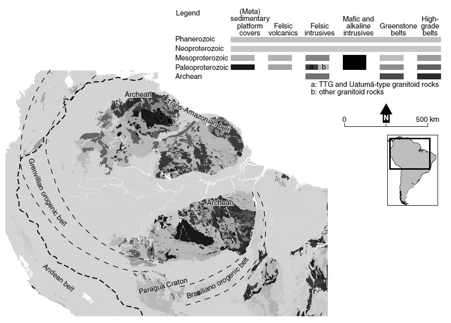
The Amazonian Craton forms the oldest nucleus of the South American continent, and is divided by the Amazon drainage basin into two parts, the Guiana Shield in the north, and the Guaporé or Central Brazilian Shield in the south (Fig. 2.1 & Plate 6). In all modern syntheses, the main geological units of the Guiana Shield continue below the Amazon drainage basin into the Guaporé Shield without offset (Tassinari & Macambira 1999, 2004; Almeida et al. 2000; Cordani et al. 2000; Santos et al. 2000; Tassinari et al. 2000; Santos 2003; Cordani & Teixeira 2007). The Amazonian Craton also continues westwards below the cover of the sub-Andean basins, as numerous blocks of Precambrian rocks have been incorporated into the cordilleras of the northern Andes during orogeny (Fig. 2.1), and seismic data and drilling by oil companies in the foreland basins invariably show the presence of Precambrian basement below (Kovach et al. 1976).
This means that the western Amazon drainage basin, on which this book focuses, is underlain in its entirety by continental crust. As the oldest sediments in the deepest part of the Paleozoic basin system itself are of Ordovician age (Wanderley Filho et al. 2005; see also Chapter 3) the geological history of the Amazonian Craton is essentially restricted to the Precambrian. In predrift reconstructions the Amazonian Craton forms part of western Gondwana. It has its counterpart in western Africa, and southwards and eastwards it continues into other cratonic parts of the South American Platform (Fig. 2.1), but we will not consider these correlations further afield.
Knowledge of the geology of the craton is of paramount importance for anyone studying the history of the basins that surround it. The origin and configuration of the basins themselves reflect tectonic patterns and processes, which often can be traced back to the early history of the craton (Brito Neves 2002). The craton is the source of most of the sediments in the intra- and pericratonic sedimentary basins, and cratonic sediments often have a specific provenance fingerprint when compared with those from the other major source, the Andes (Franzinelli & Potter 1983; Potter 1994; see also Chapter 7). Past and present relief and drainage patterns in the craton not only reflect major uplift and subsidence events, but also minute differences in the susceptibility of specific lithologies to weathering and erosion.
Understanding the history of the Amazonian Craton is hampered by many factors. In the first place, tropical rainforest and deep weathering adversely influence outcrop condition and accessibility. A serious survey of the geological features started only in the 1960s and 1970s, when detailed photogeological studies, such as in Suriname, were carried out, aerogeophysical surveys and extensive radar imagery was obtained through projects like Radambrasil in Brazil, Codesur in Venezuela and Proradam in Colombia; moreover, geochronological, structural and petrological data from numerous field surveys came pouring in. Since then, many excellent reviews of the geology of the craton have been made, including Amaral (1974), Mendoza (1974), Gibbs & Barron (1983, 1993), Teixeira et al. (1989), Cordani & Sato (1999), Cordani & Teixeira (2007), Tassinari & Macambira (1999, 2004), Santos et al. (2000), Almeida et al. (2000), Tassinari et al. (2000) and Delor et al. (2003). This chapter is based on our own field experiences in the Guiana Shield, especially in Suriname and Colombia, and to a lesser extent in French Guiana, Venezuela and Brazil, and furthermore a large amount of literature in international and local journals and books. It is difficult to do justice to the enormous amount of data and analyses that have been obtained during the last decades, and this review does not pretend to do more than sketch the bare outlines of what we think are the most salient features of the craton.
The Amazonian Craton consists essentially of three major groups of basement terranes: (i) greenstone belts, consisting of intensely folded, low-grade metasedimentary and metavolcanic rocks intruded by tonalitic plutons; (ii) high-grade metamorphic belts, consisting mainly of gneisses and granulites of varying parentage; and (iii) vast expanses of granitic and acid metavolcanic rocks, in which supracrustals are scarce. In several areas flat-lying Precambrian to Ordovician sandstones unconformably overlie the crystalline basement in impressive table mountains. Mafic dykes of greatly varying ages have intruded the basement as well as the sandstone plateaus. There is very little evidence of Precambrian fossil life in the Amazonian Craton, and therefore reconstructing its tectonic history hinges completely on isotope geochronology. In this chapter we follow the internationally agreed subdivisions of the Precambrian based upon geochronological data (Gradstein et al. 2004):
Archean > 2.5 Ga
Paleoproterozoic 2.5–1.6 Ga
Mesoproterozoic 1.6–1.0 Ga
Neoproterozoic 1.0 Ga to 542 Ma
Geochronology has made great technological advances in the past 40 years. On the one hand, this is an advantage, because now we know some parts of the history with much greater accuracy than in the past. On the other hand, it has also a disadvantage in that many earlier models, made on the basis of radiometric dating methods now considered obsolete or at least questionable, have to be reconsidered entirely. In the early years, for instance, 1.2 Ga (= giga annum, 109 years) potassium-argon (K-Ar) mica ages in the Colombian Amazonia were considered to reflect the age of the rocks themselves (Pinson et al. 1962), while later rubidiumstrontium (Rb-Sr) studies (Priem et al. 1982) demonstrated this age to represent a later metamorphic overprint over an older rock. Many Rb-Sr isochrons from the 1970s and 1980s, in their turn, now have been superseded by ages obtained by SHRIMP (sensitive highresolution ion microprobe) uranium-lead (U-Pb) dating on zircons. As a result some rocks are now known to be 100 to 400 million years older than originally thought, as for instance happened to the Roraima sandstones and their intruding mafic dykes (Santos et al. 2003b). Moreover, not all geochronological data reflect the same type of event: samarium-neodymium (Sm-Nd) model ages record the first differentiation of granitic rocks from the earth’s mantle (Cordani & Sato 1999; Sato & Siga 2000), an age that may considerably predate the date of actual emplacement of a granite pluton in an orogen. Therefore, a review of the history of the Amazonian Craton cannot simply lump together all existing data, but has to make choices in the light of newer insights and dating methods.
A more fundamental problem is what weight to give to geochronological data when confronted with the major lithological and structural units of the Amazonian Craton. Age provinces and geotectonic provinces often do not correspond, and bitter controversies between geochronologists and more geodynamically oriented geologists continue up to the present day. A geochronological province maps all the rocks that show the same age in one province, irrespective of their origin. A geotectonic province, however, maps all the rocks with a common geodynamic origin together, for instance in one mountain belt, even if some radiometric ages in it do not match the general picture. A striking example of this lack of correspondence is given when comparing the geological map of the Guiana Shield by Delor et al. (2003) and of the geological sketch map of a large part of the craton by Dall’Agnol et al. (1994) with the geochronological maps by Tassinari & Macambira (1999) and Santos et al. (2000) and Santos (2003) (compare Plates 6 and 7, and see Fig. 2.4 and discussion below).
This controversy is at the heart of an old question, the subject of the International Geological Correlation Project 204, about whether the Amazonian Craton is a large Archean platform reworked and reactivated during the Proterozoic (Almeida et al. 1981), or whether its evolution is punctuated by episodic crustal accretion during the Proterozoic (Tassinari 1981; see discussion by Teixeira et al. 1989). In this chapter we will argue that the concept of geochronological provinces is no longer useful, and that many previous subdivisions of the Amazonian Craton based on geochronological provinces will have to be revised. We will also challenge the validity of the continental accretion model for the central granitoid part of the Amazonian Craton that has been in vogue in recent years on the basis of geochronological provinces.
Main subdivisions of the Amazonian Craton
The Amazonian Craton contains three important and well-recognizable orogenic belts of different age:
1 Relatively small Archean cores with ages around 2.8 Ga, encompassing the Carajás range in the easternmost Guaporé Shield, the Amapá block in the easternmost Guiana Shield, and the Imataca Complex in the northwesternmost Guiana Shield;
2 a Trans-Amazonian greenstone belt, stretching along the northern coast of almost the whole Guiana Shield for over 1500 km, with ages around 2.2 to 2.0 Ga
3 a Grenvillian belt, along the southwestern and western margin of the Amazonian Craton, with ages around 1.3-1.0 Ga.
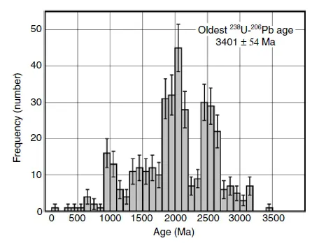
Interestingly, detrital zircons from modern Orinoco and Amazonian sediments also show a predominance of these three age groups (Goldstein et al. 1997; Rino et al. 2004) (Fig. 2.2). The Amazonian Craton is bordered in the southeast by the Neoproterozoic Tocantins-Araguaia belt (Brasiliano cycle), which will not be discussed in this chapter.
Granitoid and acid metavolcanic rocks occupy vast expanses between these three belts. The main geochronological provinces of the central part of the craton, as defined by Cordani & Sato (1999), Tassinari & Macambira (1999, 2004) and Tassinari et al. (2000), refer to these granitoid rocks. However, most of these ages are based on Rb-Sr isochrons, which are now no longer thought to reflect the age of crystallization. Santos et al. (2000), on the basis of new U-Pb zircon ages, make a different subdivision. Dall’Agnol et al. (1999) avoid the term geochronological provinces, and refer to them as blocks, using the same boundaries as Tassinari et al. (2000).
All these subdivisions cannot hide the facts that there are great overlaps in ages between the different granitoid provinces (see tables 3, 4 and 5 in Tassinari & Macambira, 1999), and that there seems to be a continuum of granitoid magmatism between 2.0 and 1.75 Ga rather than a series of discrete events as suggested by both subdivisions. Furthermore, there is a series of better defined anorogenic Mesoproterozoic granitoid intrusions, concentrated along the northwestern and southwestern parts of the shield. We will therefore stick to a more descriptive subdivision of the craton.
Archean mobile belts
What are the oldest nuclei around which the craton started to grow? There have to have been Archean cratons, if only to explain which plates caused the continental collision that gave rise to the 1500-km long Trans-Amazonian orogenic belt that stretches along the northern coast of most of the Guiana Shield and beyond; but where are they?
Unfortunately there is no easy answer to that question. There are numerous Archean ages from restricted areas in the craton, as we will see below, but as Benjamim Bley de Brito Neves (1999) states in one of the seminal papers on the craton: ‘none of these Archean terranes/cores appear as autonomous units (full cratonic areas); they consist of not-autochthonous, reworked fragments, because they were structured and incorporated in orogenic movements and processes of the Paleoproterozoic (at least)’ (translation SBK).
Serra das Carajás terrane
The only unquestionably pure Archean terrane in the Amazonian Craton is the Serra das Carajás area, which occupies a relatively restricted area in the easternmost part of the Guaporé Shield, 900 km south of Belém between the Tocantins and Xingú rivers. It is the most important mineral province of Brazil, hosting the largest iron mine in the world, and containing rich copper, gold, manganese, nickel and other ore deposits (Olszewski et al. 1989; Tassinari et al. 2000; Tassinari & Macambira 2004; Tallarico et al. 2005; Dall’Agnol et al. 2008). The area consists of two major tectonic domains: the older Rio Maria and Pau d’Arco or Inajá granite-greenstone terranes in the south, and the younger Carajás Basin proper in the north.
Granulites from the Pium high-grade terranes in the southern part of the Carajás Basin proper show Pb-Pb whole rock protolith ages of around 3 Ga, and a SHRIMP zircon U-Pb age of 2.86 Ga for the granulite-facies metamorphism (Pidgeon et al. 2000). They may represent deep slabs caught in the suture zone between the older Rio Maria terrane and the younger Carajás Basin proper (Tallarico et al. 2005).
The oldest rocks in the Rio Maria greenstone belt, the Andorinhas supergroup, give ages between 2.98 and 2.90 Ga (Tassinari & Macambira 2004). They were affected by a shear event around 2.87 Ga. The Itacaiúnas Supergroup in the Carajás Basin itself consists of a lower-grade metamorphic greenstone sequence, the Grão Pará Group, and a higher-grade Salobo Group (Tallarico et al. 2005). The metavolcanic and metasedimentary sequences of the Grão Pará Group in the greenstone belt, which contain the Banded Iron Formation (BIF) ore bodies, were deposited between 2.75 and 2.74 Ga, according to SHRIMP zircon U-Pb datings (Trendall et al. 1998; Tallarico et al. 2005), and deformed and metamorphosed between 2.58 and 2.50 Ga. Detrital zircons in these series may be as old as 3.7 Ga. The Grão Pará Group shows the classic greenstone succession of a mainly metabasaltic unit, locally with conspicuous pillow structures, minor meta-andesites and metarhyolites, followed by the BIF and topped by intermediate to acid metavolcanics and metasediments. The greenstone sequences are intruded syntectonically by tonalite-trondhjemite-granodiorite (TTG) bodies dated around 2.87 Ga.
Both domains are intruded by Archean granitic and mafic-ultramafic bodies bodies ranging in age between 2.74 and 2.53 Ga, and Paleoproterozoic granites date...