"Design for Flooding contains considerable useful information for practitioners and students. Watson and Adams fill the void for new thinking…and they advance our ability to create more sustainable, regenerative, and resilient places." —Landscape Architecture Magazine
eBook - ePub
Design for Flooding
Architecture, Landscape, and Urban Design for Resilience to Climate Change
- English
- ePUB (mobile friendly)
- Available on iOS & Android
eBook - ePub
Design for Flooding
Architecture, Landscape, and Urban Design for Resilience to Climate Change
About this book
Trusted by 375,005 students
Access to over 1.5 million titles for a fair monthly price.
Study more efficiently using our study tools.
Information
PART I
NATURE OF WATER
Watershed design and floodplain management are based on the physics of water at all scales of the hydrologic cycle.
We are tied to the ocean … and when we go back to the sea, whether it is to sail or to watch, we are going back from whence we came.
—John F. Kennedy, 1962
Figure 1.1 Self-regulating climate: Clouds form as moisture in thermals updrafts condenses upon meeting cooler air aloft, shading the land and limiting further warming. Gulf of Carpentaria, Northern Australia.
(PHOTO: © Reg Morrison)
Source: Reg Morrison, The Climate Debate, 2009, <homepage.mac.com/gregalchin/rm/pdfs/climate%20debate.pdf> .

CHAPTER 1
WEATHER
1.1 SUN AND EARTH
The thin line of life that surrounds the globe is defined by the precise juxtaposition of Earth’s orbit around the Sun, its orientation in its orbital eccentricity, and Moon’s gravitational balance. Earth’s geological history, atmosphere of oxygen and water, and magnetic field contribute to the conditions that created and sustain our biological life. Earth’s axial tilt and annual rotation around the Sun define our climates and seasons. The Sun’s radiant energy and thermal flux of lands and oceans drive the daily progression of water within the atmosphere and regions of the globe.
Earth has just the right mass, chemical composition, and distance from the Sun to permit water to exist as a liquid, solid, or gas, freely changing its state as it is transported through our atmosphere. Not a drop of liquid water has been found elsewhere in the solar system. This was not always so. Channels on Mars suggest that early in its history, its climate was warmer and it too had free-flowing water.
To understand flooding, one must understand water. To understand water, one must understand climate and weather. Variations that we experience on Earth in climate, weather, and water begin with Sun-Earth geometry. Viewed from a hypothetical position above the North Pole, the Earth orbits the Sun counterclockwise in an elliptical orbit, close to a perfect circle. The average distance to the Sun is 93 million miles (150 million km). This distance is called 1 astronomical unit of length (AU), defined by the International Astronomical Union as the mean distance between the Earth and Sun over 1 orbit of the Earth. (Figure 1.2.)
Earth’s axis is tilted 23.4° with respect to its orbital plane, defined by the line between the Sun and Earth. The angle of incidence is the angle formed between the Sun’s parallel rays and earth’s surface. This angle is known to designers familiar with requirements for window shading and solar control: For any building at any latitude, the range of solar altitude in degree angles is 23.4° + 23.4° = 46.8°.
Due to the Earth’s axial tilt, the amount of sunlight reaching the surface of Earth varies over the course of the year, and heat imbalance is created between the poles, generating conditions for global thermal flows in atmosphere and oceans. By convention, the seasons of the calendar are determined by the summer and winter solstice—when the tilt of Earth’s axis is most inclined toward or away from the Sun—and the vernal and autumnal equinox, when the angle of the tilt is perpendicular to the Sun-Earth line and the Sun directly overhead along the equator.
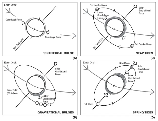
The average distance between Earth and Moon is approximately 240,000 miles (386,000 km) or, for purposes of visualization, approximately 30 times Earth’s diameter. Earth is held in orbit by the gravitational force of the Sun. Earth and Moon are influenced by mutual gravitation that counteracts their centrifugal forces. The world’s ocean mass is pulled by lunar gravity that influences tides more than the Sun’s gravitation field. (Figures 1.3 and 1.4.)
Figure 1.2 Earth, Moon, and Sun shown in scale of size and distance.
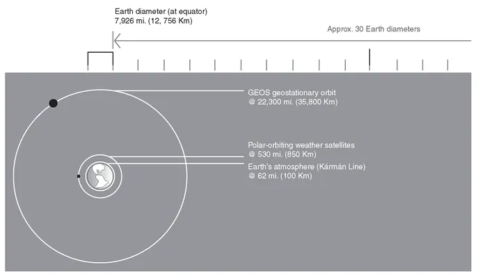
Figure 1.3a Solar geometry: Earth’s fixed angle of tilt as it orbits the Sun accounts for seasonal climate and weather.
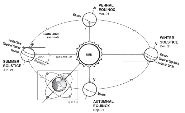
Figure 1.3b Midnight Sun: Time lapse of the Sun tracing a line just above the horizon, defining the Arctic Circle, Summer Solstice.
(PHOTO: © J. Farley)
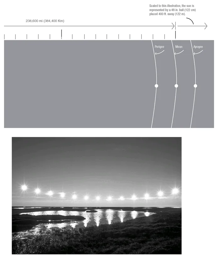
Figure 1.4 Tides and time: The ebb and flow of tides result from the 19-year metonic cycle of solar and lunar gravitational forces.
1.2 THE ATMOSPHERE
Earth is enveloped by an atmosphere comprised of gases, water, and fine dust retained by gravity and characterized by different layers of distinct temperature and composition. The atmosphere is captured by the gravitational force of its mass and density. The chemical composition of our atmosphere has been created over geologic time by compounds outgassed from Earth’s crust, or possibly from impacts of volatile compounds from comets. The atmosphere is composed of 78% nitrogen, 21% oxygen, and small amounts of carbon dioxide, argon, and other gases and an average of 1% water vapor. The oxygen is the product of organic plant growth. (Table 1.1.)
The atmosphere expands and contracts as a function of season and magnetic and solar fluxes. It constantly loses molecules of lighter gases, such as helium and hydrogen. The outer limit has no clear boundary because the layer becomes increasingly thinner with altitude until it merges with outer space. (Figure 1.5 and Table 1.2.)
TABLE 1.1 EARTH ATMOSPHERE AIR COMPOSITION BY VOLUME
| Nitrogen | 78.08% |
| Oxygen | 20.95% |
| Argon | 0.93% |
| Carbon dioxide | 0.03% |
| Traces: neon: 0.0012%; krypton: 0.00005%; xenon: 0.000006%; helium: 0.0003%; also nitrous oxide, methane, and carbon monoxide. | |
Figure 1.5 Dimensions of the atmosphere.
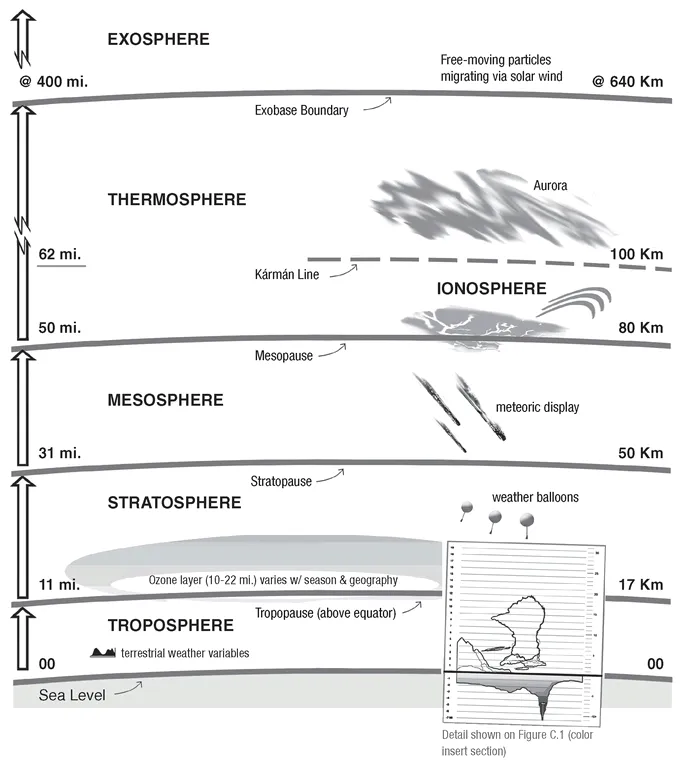
TABLE 1.2 EARTH’S ATMOSPHERIC LAYERS
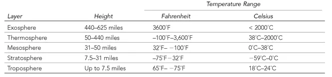
Exosphere. The outermost layer of the atmosphere in which gases get thinner and thinner and drift off into space.
Thermosphere. Temperatures generally increase with altitude, influenced by solar radiation. The gases of the thermosphere are thin but sufficient to absorb ultraviolet light from the Sun. Within the thermosphere, the ionosphere contains gas particles that are electrically charged by the Sun’s ultraviolet rays and bounce radio signals transmitted from Earth.
Mesosphere. Temperatures generally decrease with height because thinning gases do not absorb much of the Sun’s heat. The air density is sufficient to slow down meteorites hurtling into the atmosphere.
Stratosphere. Freezing temperatures gradually increase with height to about 32°F (0°C). The stratosphere contains 19% of the atmosphere’s gases, which move slowly and contain little moisture, so that clouds rarely form. Within the stratosphere is the ozone layer, a band of ozone gas that absorbs the Sun’s harmful ultraviolet rays.
Troposphere. Lowest major atmospheric layer, containing 75% of the atmospheric mass and 99% of water vapor and aerosols. Named after the Greek tropos, meaning “mixing,” it is turbulent and influenced by the surface of the Earth. The height of the troposphere varies with latitude, ranging between 5 miles (8 km) at the poles to 10.5 miles (17 km) at the equator.
The Kármán line is the adopted reference for the boundary between atmosphere and space, defined by the International Federation of Aeronautics as the “edge of space” at an altitude of 62 miles (100 km) above Earth’s surface.
All of Earth’s weather occurs in the troposphere. Energy from the Sun heats this layer and the land and oceans below, causing expansion of the air. This lower-density air then rises and is replaced by cooler, higher-density air. The resulting atmospheric circulation drives the weather through redistribution of heat energy and water in all its forms.
Earth’s surface has alter...
Table of contents
- Title Page
- Copyright Page
- PREFACE AND ACKNOWLEDGMENTS
- Foreword
- FOREWORD
- Introduction
- PART I - NATURE OF WATER
- PART II - DESIGN WITH WATER
- PART III - FLOOD-RESISTANT DESIGN
- PART IV - DESIGN FOR RESILIENCE
- EPILOGUE
- GLOSSARY
- AUTHORS AND CONTRIBUTORS
- INDEX
- FIGURES - COLOR INSERT SECTION
Frequently asked questions
Yes, you can cancel anytime from the Subscription tab in your account settings on the Perlego website. Your subscription will stay active until the end of your current billing period. Learn how to cancel your subscription
No, books cannot be downloaded as external files, such as PDFs, for use outside of Perlego. However, you can download books within the Perlego app for offline reading on mobile or tablet. Learn how to download books offline
Perlego offers two plans: Essential and Complete
- Essential is ideal for learners and professionals who enjoy exploring a wide range of subjects. Access the Essential Library with 800,000+ trusted titles and best-sellers across business, personal growth, and the humanities. Includes unlimited reading time and Standard Read Aloud voice.
- Complete: Perfect for advanced learners and researchers needing full, unrestricted access. Unlock 1.5M+ books across hundreds of subjects, including academic and specialized titles. The Complete Plan also includes advanced features like Premium Read Aloud and Research Assistant.
We are an online textbook subscription service, where you can get access to an entire online library for less than the price of a single book per month. With over 1.5 million books across 990+ topics, we’ve got you covered! Learn about our mission
Look out for the read-aloud symbol on your next book to see if you can listen to it. The read-aloud tool reads text aloud for you, highlighting the text as it is being read. You can pause it, speed it up and slow it down. Learn more about Read Aloud
Yes! You can use the Perlego app on both iOS and Android devices to read anytime, anywhere — even offline. Perfect for commutes or when you’re on the go.
Please note we cannot support devices running on iOS 13 and Android 7 or earlier. Learn more about using the app
Please note we cannot support devices running on iOS 13 and Android 7 or earlier. Learn more about using the app
Yes, you can access Design for Flooding by Donald Watson,Michele Adams in PDF and/or ePUB format, as well as other popular books in Architettura & Design e architettura. We have over 1.5 million books available in our catalogue for you to explore.