Rockfall Engineering is an up-to-date, international picture of the state of the art in rockfall engineering.
The three basic stages of rockfalls are considered: the triggering stage, the motion stage, and the interaction with a structure stage; along with contributions including structural characterization of cliffs, remote monitoring, stability analysis, boulder propagation, design of protection structures an risk assessment.
Academic contributions are illustrated by practical examples, and completed by engineering contributions where practical purposes are thoroughly considered. This title is intended for engineers, students as well as researchers.
Geophysical Detection and Characterization of Discontinuities in Rock Slopes1
1.1. Introduction
Rockfalls pose critical problems to risk management in mountain areas. Rockfalls are difficult to predict due to phenomenon suddenness, lack of identified reliable precursors, poor information on the internal structure of the rock mass and the multiplicity of triggering factors (freeze thaw cycles, earthquakes, human activities, water infiltration) [FRA 06]. Rock mass stability assessment requires detailed investigations of the discontinuity pattern and the 3D geometry of the potential unstable block [HOE 81].
In the context of rock cliffs, three types of investigations can be performed for predicting rockfalls:
1. geological and structural observations of the cliff face and the plateau, including in open rock fractures on cliff or rocks where they are accessible;
2. remote sensing measurements (mainly photogrammetry and laser scan), which would enable us to obtain a digital surface model of the cliff;
3. geophysical experiments conducted on the plateau and/or on the cliff face.
The remote sensing techniques and their applications for monitoring rock slopes are described in Chapter 2 of this book and will not be discussed here. This chapter will focus on the description of geophysical methods which are useful in this context, since they allow us to delineate the mass fracture pattern from measurements on the plateau and/or on the cliff face. A review of the different geophysical methods and their sensitivity has been provided initially. In the second part, case studies performed on various cliffs around Grenoble have been discussed.
1.2. Geophysical parameters and methods
1.2.1. Introduction
Geophysical methods have been increasingly used for slope investigation (for a review see [JON 07]). They are based on physical measurements conducted in the field from which physical parameters can be deduced, generally through an inversion or imagery process. The measured data and corresponding parameters have been summarized in Table 1.1 for the main geophysical techniques (seismic, electrical, gravimetry, magnetism, electromagnetism, radar). It is beyond the scope of this chapter to detail the methods that are described in general books [TEL 90, REY 97, SHA 97, KEA 02]. Geophysical techniques offer many advantages, as compared to geotechnical techniques. Geophysical techniques are fast, non-invasive and deployable on slopes. In addition, they allow us to investigate large volumes of material and provide 2D or 3D images of the subsurface [JON 07]. On the other hand, contrary to geotechnical techniques, they suffer the following drawbacks: i) when measurements are made at the surface, their resolution decreases with depth; ii) the solution is generally non-unique for a given data set, except for reflection-based methods, and iii) they provide physical parameters instead of geological or geotechnical properties. These characteristics outline the complementarities between the two families of investigation techniques.
Table 1.1.Major geophysical techniques, corresponding data and derived parameters
Method
Measurement
Physical parameter
Seismic
Propagation time
Wave velocity
Electrical
Electrical potential
Electrical resistivity
Gravimetry
Gravitational acceleration
Density
Magnetism
Magnetic field
Magnetic susceptibility
Electromagnetism
Electromagnetic field
Electrical resistivity
Radar
Propagation time
Dielectric constant
Selection of the geophysical methods is based on the problem to be solved. [MCC 90] has identified 4 factors which have to be considered while designing a geophysical survey: the existence of a geophysical contrast corresponding to the campaign target (e.g. the limit of the sliding mass), the penetration depth and the resolution (ability of the method to detect a body of a given size or thickness at the desired depth), the quality of the geophysical signal (noise perturbations) and the necessity to calibrate the geophysical results by geotechnical and geological data. This often requires that preliminary tests be conducted before designing a geophysical survey.
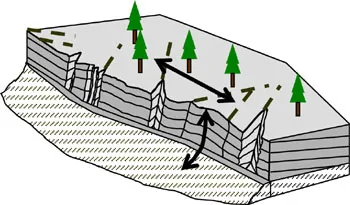
In the context of rock stability assessment, the two principal objectives of geophysical experiments are usually to characterize the fracturing pattern inside the rock mass and to delineate the prone-to-fall block geometry. In the context of a cliff or high slope geometry, measurements can be performed on the top (plateau) or on the cliff face (Figure 1.1). Geophysical investigation of the plateau may provide valuable information about the continuity of out-cropping structures (fractures, faults) or the rock quality [DUS 03, BUS 06, HEI 06]. However, the investigation depth could be low, when compared to the cliff height, and the method resolution method generally decreases with depth. Whenever possible, the use of GPR (ground-penetrating radar) on the cliff face has been found to be the most valuable tool, in terms of resolution for investigating a rock mass [DUS 03, ROC 06, JEA 06, DEP 07, DEP 08]. However, the use of GPR for cliff investigation can be limited due to safety requirements for abseiling (climbing down the front of a large rock while holding on to the rope) and by the penetration depth which can be reduced due to low electrical resistivity values of the rock.
Figure 1.1.Cliff geometry showing bedded limestone overlying a marl layer, along with the location of potential geophysical profiles (double arrows) on the plateau or on the cliff face. Fracturing is highlighted with bold dotted lines
In the following subsections (2.2 to 2.5) the main physical parameters and the associated methods applicable to rockfall investigation have been described. The first three geophysical parameters (seismic velocity, electrical resistivity and dielectric permittivity) are common properties, which are used in many engineering and environmental geology applications [REY 97]. On the contrary, the resonance frequency, which is derived from seismic noise tests records, is a mechanical parameter which is frequently used for seismic site effect assessment [BON 06], but, is rarely applied to rockfall hazard assessment.
1.2.2. Seismic velocity
1.2.2.1. Background
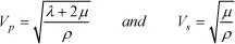
When a local stress on a material (with a seismic source for example) is applied, an elastic strain energy would be propagated as seismic waves. Depending on the seismic source considered, two types of volume waves are generated, i.e. compression-dilatation waves (P waves) and shear waves (S waves). As P waves generate a volume change without any rotation of the material particles, particle displacements would occur in the direction of propagation. For S waves, particle movement is located in a plane that is perpendicular to the wave propagation direction. In any seismic survey, the main parameter which may be easily quantified is the seismic velocity distribution. It may be assessed with a certain resolution, which depends on the seismic method used (reflection, refraction, tomography), on the seismic source (frequency content), and the source-receiver configuration. Considering an elastic material, P and S wave velocities can be expressed as a function of elastic parameters, by assuming that the considered material in the absence of interstitial water is isotropic: (subsurface water contained in pore spaces between the grains of rock).
[1.1]
where λ and μ are the Lamé (coefficients describing the relation between stress and deformation in linear elastic) and ρ is the density of the material. It is clear from this relation that P wave velocity (Vp) is always greater than S wave velocity (Vs).
Presence of fractures or faults within the rock mass reduces the wave velocities. The decrease of wave velocities depends on the size, density and properties (filling, aperture) of fracture. Air-filled fractures can induce a stronger velocity reduction, than a filling with water (Vp = 1,500 m/s compared to 300 m/s). Velocity sensitivity to fractures and the resulting anisotropy have been increasingly analyzed by oil companies for reservoir purposes, but have been seldom quantitatively analyzed in rock engineering applications [MAV 95]. 2D and 3D seismic tomography can currently provide a useful tool to characterize unstable slope. [HEI 06] has seismically imaged a moving rock mass, to reveal the presence of a large volume of rock wi...
Table of contents
Cover
Title Page
Copyright
Foreword
Introduction
Chapter 1: Geophysical Detection and Characterization of Discontinuities in Rock Slopes
Chapter 2: Remote Sensing and Monitoring Techniques for the Characterization of Rock Mass Deformation and Change Detection
Chapter 3: Mechanical Stability Analyses of Fractured Rock Slopes
Chapter 4: Assessment of Constitutive Behaviors in Jointed Rock Masses from a DEM Perspective
Chapter 5: Methods for Predicting Rockfall Trajectories and Run-out Zones
Chapter 6: Rockfall Dynamics: A Critical Review of Collision and Rebound Models
Chapter 7: Rockfall Hazard Zoning for Land Use Planning
Chapter 8: Rockfall Quantitative Risk Assessment
Chapter 9: Multi-scale Analysis of an Innovative Flexible Rockfall Barrier
Chapter 10: A New Design Method for Rockfall Shelters Covered by Granular Layers
Chapter 11: Design Procedure for a Three-Layer Absorbing System in Rockfall Protection Galleries
Chapter 12: Ground Reinforced Embankments for Rockfall Protection: From Real Scale Tests to Numerical Modeling
List of Authors
Index
Frequently asked questions
Yes, you can cancel anytime from the Subscription tab in your account settings on the Perlego website. Your subscription will stay active until the end of your current billing period. Learn how to cancel your subscription
No, books cannot be downloaded as external files, such as PDFs, for use outside of Perlego. However, you can download books within the Perlego app for offline reading on mobile or tablet. Learn how to download books offline
Perlego offers two plans: Essential and Complete
Essential is ideal for learners and professionals who enjoy exploring a wide range of subjects. Access the Essential Library with 800,000+ trusted titles and best-sellers across business, personal growth, and the humanities. Includes unlimited reading time and Standard Read Aloud voice.
Complete: Perfect for advanced learners and researchers needing full, unrestricted access. Unlock 1.4M+ books across hundreds of subjects, including academic and specialized titles. The Complete Plan also includes advanced features like Premium Read Aloud and Research Assistant.
Both plans are available with monthly, semester, or annual billing cycles.
We are an online textbook subscription service, where you can get access to an entire online library for less than the price of a single book per month. With over 1 million books across 990+ topics, we’ve got you covered! Learn about our mission
Look out for the read-aloud symbol on your next book to see if you can listen to it. The read-aloud tool reads text aloud for you, highlighting the text as it is being read. You can pause it, speed it up and slow it down. Learn more about Read Aloud
Yes! You can use the Perlego app on both iOS and Android devices to read anytime, anywhere — even offline. Perfect for commutes or when you’re on the go. Please note we cannot support devices running on iOS 13 and Android 7 or earlier. Learn more about using the app
Yes, you can access Rockfall Engineering by Stéphane Lambert, François Nicot, Stéphane Lambert,François Nicot in PDF and/or ePUB format, as well as other popular books in Technology & Engineering & Civil Engineering. We have over one million books available in our catalogue for you to explore.