The fully-revised second edition of the bestselling textbook—an original interpretation of the entire span of California history
The rich history of California can best be told through its connection with the Pacific Basin. From the geological origins of the land and its earliest seafaring inhabitants, to current economic trade relationships and remarkably diverse cultural influences, the factors that continue to shape the Golden State are inseparably linked to the vast ocean to its west. Pacific Eldorado is a comprehensive exploration of the entire sweep of California's past in relation to the maritime world of the Pacific Basin. Offering a bold and original interpretation of the history of the region, prominent historian Thomas J. Osborne enables readers to view the state's development through a Pacific-focused lens.
Now in its second edition, this acclaimed textbook reflects new scholarship, places greater emphasis on environmental topics, and examines recent California history. Designed to help students think critically about commonly-held ideas, the author challenges conventional views, such as those of pre-Gold Rush California, confronts the traditional Atlantic-centric approach to American history, and presents a new analytic framework for studying the state's past. The text enables students to understand the evolution of California, from the time of prehistoric Asian seafarers to the state's present-day position as the nation's wealthiest and most populous state. Rigorous yet accessible, this text:
Explores a "Greater California" history that extends beyond geographic borders
Offers new, expanded, and revised coverage of plate tectonics, the citriculture boom of the late 1800s, the environmental history of California, and more
Features "Pacific Profiles," brief chronicles of notable figures who have made an impact on the state's history
Has a new feature, "Transpacific Connections" that illustrates further the fascinating ties between California and the Pacific World; for example, comparing the California gold rush to the contemporaneous New Zealand gold rush and indicating the connections between the two
Supports a Pacific-centric approach with compelling examples, such as the building of the transcontinental railroad to increase the China trade
Includes new and updated photographs, illustrations, maps, references, and reading suggestions
Already adopted by a wide range of institutions, the new edition of Pacific Eldorado: A History of Greater California continues to be an essential resource for students and instructors in California history courses, as well as those required to pass exams on California history and government to obtain California teaching credentials.
Trusted by 375,005 students
Access to over 1.5 million titles for a fair monthly price.
1 Beginnings: From Fire and Ice to Indian Homeland
Fire and ice forged the physical setting of California's storied past. No matter how extensively humans have altered that setting with mining activities, transportation systems, aqueducts, and various other built structures, nature always has been integral to the state's history. Before there was a human record there was pre‐history, or a time of beginnings, by far the longest period in California's timeline. During this genesis California literally rose from the Pacific, at times spewing flames and volcanic ash. Violent thrusts from below the Earth's surface formed mountains and valleys that later would be carved by huge rivers of ice. Before these glaciers melted, leaving an ice‐free corridor southward about 12,000 years ago, America's first human inhabitants began making their way by watercraft from Asia to North America. On reaching the New World, seagoing Asian migrants navigated North America's coastline southward to the Channel Islands and mainland. Later their mammoth‐hunting counterparts on land trekked southward and eastward, some settling in what would become California. These voyaging and trekking Paleolithic, or Old Stone Age, peoples were the first human occupants of this remarkable land. Some scholars speculate that Polynesian and Chinese Pacific voyagers visited Indian California centuries before Europeans arrived in the province.
Timeline
30 million years ago
California's land mass is formed by Pacific geological processes, especially through plate tectonic subductions and lateral movements
13,000 years ago
Following the “Kelp Highway,” Asian Pacific voyagers arrive in the Channel Islands, likely becoming the first Californians, according to archeologist Jon M. Erlandson and others The Arlington Woman, so‐called by scientists, lives and dies at a site on Santa Rosa Island along California's coast
10,000–15,000 years ago
As climate warming set in and Beringia melted into the Bering Strait, the descendants of Paleo‐Indian migratory hunters continue on their way eastward and southward throughout the New World in pursuit of game
4,600 years ago
A bristlecone pine (Pinus longaeva), located in California's White Mountains and dating back more than four millennia, is thought to be the oldest living thing on Earth
2,000 years ago
Some of today's California redwood trees, the world's largest living things, date to the time of Jesus of Nazareth and the Roman Empire
1000 CE
Chumash Indians build a seafaring culture in and around today's Santa Barbara and on a few of the Channel Islands
400–800
Though questionable, early Polynesians may have reached California in watercraft, according to a very small group of anthropologists and linguists
1500s
Specialists estimate that 15,000 Chumash lived in California at the time of European contact
Late 1700s
Between 300,000 and 1,000,000 indigenous people inhabited California most of them living in villages of 100–500 dwellers
Landforms
Not only was California born of the Pacific, but it is also situated on the Ring of Fire, an intercontinental perimeter of volcanoes and earthquake faults that line the Pacific Rim in a sweeping arc from New Zealand to Chile. Like many other areas along the Ring of Fire, the state's varied landmass was assembled over time from geologic fragments of rocks and sediments, called “terranes,” lying on the crust or floor of the Pacific long after the Earth was formed some 4.6 billion years ago. Before these fragments began uplifting from the ocean, North America's western shoreline extended to about where the Rocky Mountains are situated today. West of that ancient coastline loomed the vast, heaving Pacific.
According to widely accepted plate tectonics theory, formulated by geologists in the mid‐1960s, California's landmass has evolved over hundreds of millions of years. The process has been global and ongoing. Eons ago 20 huge subterranean masses of material, called plates, comprised the Earth's crust and upper mantle. These plates meandered due to heat and pressure from deep within the planet, creating continents. The largest of these subterranean masses, the Pacific Plate, lies beneath roughly two‐thirds of the ocean by that name. The eastward‐moving Pacific Plate collided with the western edge of the North American Plate in a zone somewhat west of the Rockies. At the point of collision the Pacific Plate subducted, that is, pushed beneath the North American Plate, thereby generating enormous heat. The heat, in turn, melted subterranean basalt rock that combined with deeply buried sediments to produce ores – including gold that in the mid‐1800s sparked a worldwide rush to California – while pushing up the Earth's crust and forming granite outcroppings. In this way western mountains and their basins came into existence. The initial collision was followed by subsequent ones, called “dockings” or “accretions,” that assembled California's topography, which included offshore volcanic islands. “Wherever you stand in this state,” says geologist Keith Heyer Meldahl, “if your feet are on bedrock, the odds are that you're standing on an immigrant [piece of ground], reeled in by subduction from the far reaches of the Pacific in the process of assembling California.” About 30 million years ago, when the area for the most part assumed its present geographical configuration, these west‐to‐east collisions stopped and a lateral south‐to‐north movement of the Pacific Plate began that continues to this day.
This lateral movement has had major consequences for the region, especially in terms of earthquakes. The Pacific Plate has been moving northwestward at about 2 inches a year. Consequently, part of Baja California was carried over millions of years to the coastline and interior reaches of southern California and up to San Francisco. This movement has been characterized by gnashing and grinding along the Pacific–North American plates' subduction zone. Stresses from the lateral movements of the two plates force an unlocking of surface‐area terrain on both sides of the fissure known as the San Andreas Fault. The forced unlocking of these blocks results in powerful earthquakes along this fault system that extends from Point Reyes Peninsula just above San Francisco southeastward for 350 miles to the mountains of southern California. Earthquakes along that fault line have devastated cities, leaving many dead and striking fear into survivors. Such was the case in 1906 when much of San Francisco was flattened and burned (due to ruptured gas lines and water mains in the city) by a severe earthquake along the San Andreas Fault. Since 1769, when the Spanish began colonizing the province, there have been 117 measured or recorded earthquakes along this fault. Geology and geography augur more to come on this and other faults in the state.
Volcanoes, plate tectonics, earthquakes, winds, and waves have formed California's coastline, offshore islands, mountains, and basins or valleys. That coastline, with its many picturesque coves and tree‐crested cliffs, is one of the most photographed and tourist‐visited in the world, extending 1,264 miles in length. Monster waves, or tsunamis, generated by distant earthquakes, have on occasion reportedly reached 195 feet in height before bombarding northern California's shores. Such a wave struck just north of Humboldt Bay in 1913. Less noteworthy yet still powerful currents of wind and sea have been sculpting coastal California for eons.
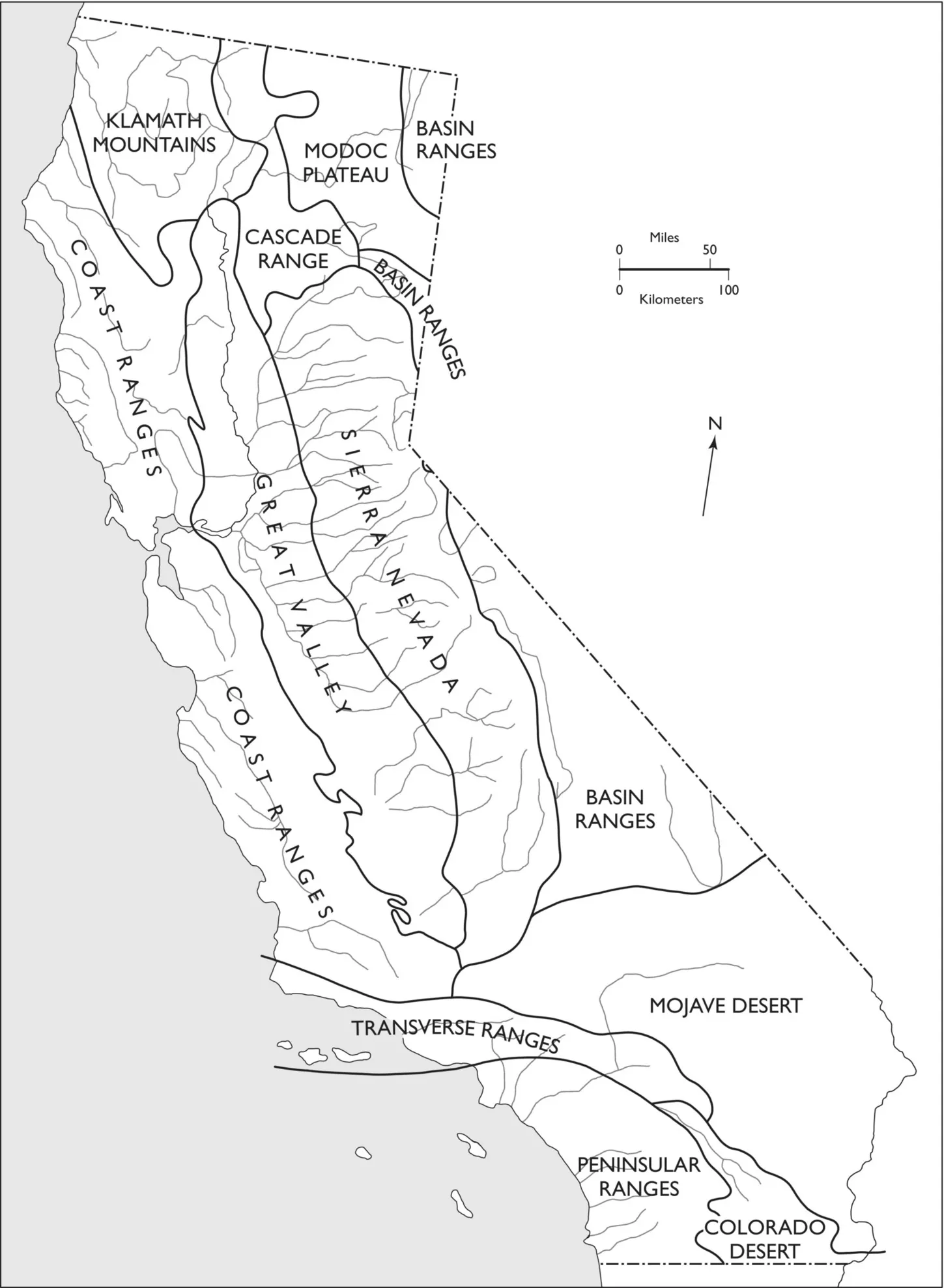
Inland from the coast, mountain ranges and plateaus of dramatically varying elevations dominate most of the state's nearly 100 million acres of surface area. America's third‐largest state, after Alaska and Texas, California features at least half a dozen ramparts.
Two mountain chains and a high plateau occupy much of the far northern reach of the state's boundaries. The Klamath range is located in the northwest corner of the state. Two major rivers, the Klamath and Trinity, flow through the mountains' gorges, emptying into the Pacific. To the east the volcanic‐created Cascades, which lie on a north–south axis from Washington to northern California, feature such peaks as Mt. Shasta (14,162 feet) and Mt. Lassen (10,457 feet), both of which resulted from thunderous, fiery eruptions along the Pacific Ring of Fire. Mt. Shasta's volcanic origin goes back about 50 million years ago, while Mt. Lassen is around 200,000 years old. The Modoc Plateau, covered with rugged lava flows and site of an 1873 war between whites and Indians, is tucked in the northeastern corner of the state.
Slightly south of the Cascades, California's highest range – the Sierra Nevada – begins its more than 400‐mile span along part of the state's eastern boundary. This relatively young rampart, the world's longest and some 50 million years old (according to a team of Stanford scientists), is still rising, unlike the Appalachians in the eastern United States. The twin jewels of the Sierra, some say, are the glacial‐carved Yosemite and Hetch‐Hetchy valleys. The former is world‐renowned for its granite cliffs and majestic waterfalls; the latter was transformed into a reservoir for San Francisco in the early twentieth century. A major obstacle to early overland migrants and the major construction challenge to builders of the nation's first transcontinental railroad, the Sierra boasts the highest peak in the contiguous 48 states – Mt. Whitney (14,495 feet). Fifty other Sierra peaks measure above 13,000 feet. The eastern slopes of the Sierra Nevada, which rise abruptly out of a largely treeless basin, are especially steep as those who have hiked in that region will attest.
Figure 1.1 California topography. The variation in the state's topography is unmatched nationwide.
Source: Based on Mary Hill , California Landscape: Origin and Evolution, revised edition (Berkeley: University of California Press 1985), p. 24 . Reprinted by permission of University of California Press.
Beyond impressive recreational opportunities and perhaps unparalleled aesthetic endowments, the Sierra Nevada range has been a storehouse of riches in pelts, ores, timber, and water. For, example, Chinese miners in the 1850s referred to the Sierra as Gam Saan, Gold Mountain. Other valuable ores, like tungsten (used in weapon‐making), were mined in the twentieth century. Rivers flowing from the Sierra, like the Feather and Tuolumne, have furnished hydroelectric power and water to farmers and thirsty Californians. Sapphire‐blue Lake Tahoe, the state's largest body of fresh water, is but one of the many lakes carved by Sierra glaciers.
The Great Basin – comprising parts of Oregon, Idaho, Wyoming, Utah, Arizona, Nevada, and California – lies just east of the Sierra. I...
Table of contents
Cover
Table of Contents
Illustrations
Foreword
Preface to the Second Edition
Acknowledgments
1 Beginnings: From Fire and Ice to Indian Homeland
2 Spain's Greater California Coast
3 A Pacific‐Oriented Mexican Province
4 War and Gold: America’s West Coast Eldorado
5 National Crisis, Statehood, and Social Change
6 Pacific‐Bound Rails, Hard Times, and Chinese Exclusion
7 Eldorado’s Economic and Cultural Growth
8 Anti‐Railroad Politics, Municipal Graft, and Labor Struggles
9 Governor Hiram Johnson and Pacific‐Oriented Progressivism
10 Good Times and Bad in a Pacific Rim Super State
11 America’s Pacific Bulwark: World War II and Its Aftermath
12 Pacific‐Edge Liberalism at High Tide
13 “Gold Coast” Conservatism and the Politics of Limits
14 The Ongoing Pacific Shift
Appendix: Governors of California, 1768–2019Appendix: Governors of California, 1768–2019
Index
End User License Agreement
Frequently asked questions
Yes, you can cancel anytime from the Subscription tab in your account settings on the Perlego website. Your subscription will stay active until the end of your current billing period. Learn how to cancel your subscription
No, books cannot be downloaded as external files, such as PDFs, for use outside of Perlego. However, you can download books within the Perlego app for offline reading on mobile or tablet. Learn how to download books offline
Perlego offers two plans: Essential and Complete
Essential is ideal for learners and professionals who enjoy exploring a wide range of subjects. Access the Essential Library with 800,000+ trusted titles and best-sellers across business, personal growth, and the humanities. Includes unlimited reading time and Standard Read Aloud voice.
Complete: Perfect for advanced learners and researchers needing full, unrestricted access. Unlock 1.5M+ books across hundreds of subjects, including academic and specialized titles. The Complete Plan also includes advanced features like Premium Read Aloud and Research Assistant.
Both plans are available with monthly, semester, or annual billing cycles.
We are an online textbook subscription service, where you can get access to an entire online library for less than the price of a single book per month. With over 1.5 million books across 990+ topics, we’ve got you covered! Learn about our mission
Look out for the read-aloud symbol on your next book to see if you can listen to it. The read-aloud tool reads text aloud for you, highlighting the text as it is being read. You can pause it, speed it up and slow it down. Learn more about Read Aloud
Yes! You can use the Perlego app on both iOS and Android devices to read anytime, anywhere — even offline. Perfect for commutes or when you’re on the go. Please note we cannot support devices running on iOS 13 and Android 7 or earlier. Learn more about using the app
Yes, you can access Pacific Eldorado by Thomas J. Osborne in PDF and/or ePUB format, as well as other popular books in History & North American History. We have over 1.5 million books available in our catalogue for you to explore.