Ranging geographically from Tierra del Fuego to California and the Caribbean, and historically from early European sightings and the utopian projects of would-be colonizers to the present-day cultural politics of migrant communities and international relations, this volume presents a rich variety of case studies and scholarly perspectives on the interplay of diverse cultures in the Americas since the European conquest.
Subjects covered include documentary and archaeological evidence of cultural interaction, the collection of native artifacts and the role of museums in the interpretation of indigenous traditions, the cultural impact of Christian missions and the representation of indigenous cultures in writings addressed to European readers, the development of Latin American artistic traditions and the incorporation of motifs from European classical antiquity into modern popular culture, the contribution of Afro-descendants to the cultural mix of Latin America and the erasure of the Hispanic heritage from cultural perceptions of California since the nineteenth century.
By offering accessible and well-illustrated accounts of a wide range of particular cases, the volume aims to stimulate thinking about historical and methodological issues, which can be exploited in a teaching context as well as in the furtherance of research projects in a comparative and transnational framework.
Trusted by 375,005 students
Access to over 1.5 million titles for a fair monthly price.
At one point in his account of Tierra del Fuego and its inhabitants in the period around 1900, E. Lucas Bridges (1988:336), the third white native of Ushuaia, writes:
Across leagues of wooded hills up the forty-mile length of Lake Kami, Talimeoat and I gazed long and silently towards a glorious sunset. I knew that he was searching the distance for any sign of smoke from the campfires of friends or foes. After a while his vigilance relaxed and, lying near me, he seemed to become oblivious of my presence. Feeling the chill of evening, I was on the point of suggesting a move, when he heaved a deep sigh and said to himself, as softly as an Ona could say anything: ‘Yak haruin.’ (‘My country.’)1
We do not know how Talimeoat pronounced these words, and we do not know how his words echoed. There were no roads, no farms off which it bounced, nothing that resembles a human landscape for us. In the world as we know it, everywhere we look we see signs, things that have names, things that humans have created, the world is full of built things, our language has many words for things that humans produced. But his was a language with more than 30,000 words that was spoken by a people who did not produce many things – hunter-gatherers and fishermen, who lived in a landscape where they left no objects behind. What were these words referring to, what were these people looking at? The shape of their world was lost when the last indigenous died in the twentieth century. Yet in this chapter I want to speak about their world, Tierra del Fuego, and its discovery, conquest and colonization through the eyes of history: maps.2 Visible communication about this region and its people was made meaningful at the expense of peoples who had a history of their own.
Cartography
Tierra del Fuego made its first appearance on the world stage after the Portuguese Ferdinand Magellan and his men from all over Europe discovered it in 1520. The Spanish crown had set up this expedition in response to the Treaty of Tordesillas, which was signed in 1494, two years after the Italian Christopher Columbus in service of the Spanish crown discovered America. The Treaty – an intervention by the Pope in the dispute between Portugal and Spain over the ownership of trade routes and new land – divided the New World and the Atlantic Ocean between the two states along a meridian that cut through land and water. By extending the notion of ownership of territory to include water, it laid the basis for sea law. The purpose of the Spanish expedition of 1519–22 was to find a westward route through their allocated territory to the Spice Islands of the Indies.
Somewhere in present-day Argentina they encountered giants with big feet (and dog-headed battle masks), Patagones. That land was henceforth known as Patagonia, land of big feet. Another possible origin of the name was that seven years before Magellan sailed the romance Primaleon of Greece, featuring a dog-headed monster called the Grand Patagon, had appeared in Spain. Further down they found a strait, later known as the Strait of Magellan, which brought them to the other side of the New World. The wind was down and the sea was calm, so the sea that they sailed into was named the Pacific Ocean. While sailing through the strait they had seen fires that appeared to set the land south of them on fire, so that land was called Tierra del Fuego, the Land of Fire. It was assumed that this land belonged to Tierra Australis, Southern Land, a hypothetical continent believed to hold the earth in balance at its poles.
Whereas the Patagonians were a creation of the Italian Antonio Pigafetta, whose journal was reprinted at home and became an important source for mapmakers across Europe, Tierra Australis was an idea handed down from classical authors. Long before Magellan went south-westward, and long before the Portuguese Bartolomeu Dias went south-eastward and discovered the tip of Africa in 1488, the ancient Greek geographer Strabo and the Roman Ptolemy proposed that there was an unknown landmass in the southern seas. Other authoritative authors from antiquity, such as the natural historian Pliny the Elder, handed down the belief that fantastic creatures dwelled deep in nature. Late medieval travel accounts of John Mandeville and Marco Polo further contributed to the notion of the fabulous, e.g. men with tails. The unspecific eyewitness accounts of sailors seeing animals in the sea and the often-romanticized narratives of navigators in contact with indigenous people were interpreted according to what the mapmakers at home could only guess from their classical education and medieval reading. The Patagonians and Tierra Australis especially were recurrent signs on maps until far into the seventeenth century, no matter the country of origin. Tierra de Patagones was a different name than the toponyms of other regions, which were not called after a people, such as Regio de Brasil, Regio del Peru, Nova Andalusia, Nueva Espana. This part of America was however signified by beings, who, when they appeared on maps, were always seen as doing a range of things in an otherwise uninhabitable land: either swallowing an arrow, or showing off their height to a small European, or leaning against a harpoon, or hunting a bird, and almost always naked. The Patagonian on the map was a playful figure, but uncivilized nonetheless, and in a barren landscape. Whenever there was a comment that went together with a map that included Patagonia, it stressed the height of the Patagonians, how their faces were painted with all kinds of colors, and that they were man-eaters: anthropophagi.
During the sixteenth century many geopolitical changes occurred in Europe at the same time as the conquest and colonization in America. There was the consolidation of the Reformation (from 1517), the Eighty Years’ War (1568–1648) between the northern provinces of the Habsburg Empire and its central authority, borders were constantly changing, and people were on the move. Thousands migrated to Amsterdam, which also helped to provide for the growing population in western Europe by becoming the staple transit place for grain surpluses from the countries around the Baltic Sea. This trade required good navigation procedures, assisted by caert-schrijvers (map scribes), who provided general sailing instructions and the laws of the sea, as well as maps of specific seas. Migrants stimulated further economic expansion by opening publishing houses and artisan workshops, and by extending their trading business. At the time, for navigation beyond the coasts of Europe, the Dutch were dependent upon the geographical and hydrographical knowledge of cosmographers, mapmakers, and seafarers from Spain, Portugal, and England. Their journals, travel accounts and manuals were imported, translated and studied, and also maps were imported, reproduced, and studied. This is how people learned of the English expedition that Francis Drake led through the Strait of Magellan in 1578. The sea on the other side of America however was ‘so violent and of such continuance not seen since Noah’s flood.’ His boat, the Golden Hind, was swept all the way south, covering the first part of a route that in 1820 became the route to discovering Antarctica: the Drake Passage.
Returning weakened, Drake and his men were forced to rest ashore. Here they encountered the inhabitants of Tierra del Fuego, bartered with them, and provided the first account of these people beyond the Strait of Magellan. The report did not say much; it spoke of people ‘travelling for their living from one island to another, in their canoes, both men, women, and young infants wrapped in skins, and hanging at their mothers’ back. Later we read that, along the shore, they noticed ‘some inhabitants […] manners, apparel, houses, canoes and means of living’ (Osborne 1747:451). As the English threatened Spanish colonies on the west coast of America, the Spanish king, Philip II, responded by sending an expedition to the Strait of Magellan. In 1579, Pedro Sarmiento de Gamboa was ordered to erect fortifications to prevent the passage of foreign ships. When, in 1587, the Englishman Thomas Cavendish sailed to these fortifications, however, all he found was ruins. One of them, Don Felipe, was renamed Port Famine. Of the 4,600 Spaniards, only one survived.
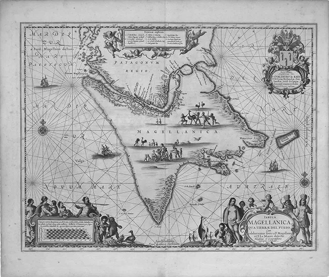
In 1592, Petrus Plancius in Amsterdam published a map of the world based on studying these accounts and other Iberian information. He presented it to the Dutch State and it became the driving force behind the establishment of Dutch trading companies and the preparation of long voyages overseas. He worked together with Cornelis Claeszoon, a publisher who was also responsible for the sea maps of Jodocus Hondius. All three were Flemish migrants. The latter teamed up with Gerardus Mercator, who was the inventor of the Mercator projection, a cylindrical representation of the world that could be stretched out flat on a map. His method subsequently became the nautical standard, and his world maps were the first to carry the title Atlas, after the Titan from Greek mythology who was condemned to carry the sky for eternity. Others called their world map Theatrum Mundi, Latin for the ‘world as a stage/theatre,’ and yet others called it Tabula, Latin for ‘tablet’, named after a Greco-Roman board game and a tablet for writing, from both of which figures could be erased and reappear. The Tabula Magellanica by the Dutch mapmaker Johannes Janssonius (Figure 1.1) implies exactly that: that the perception of Tierra del Fuego is a configuration of events. It captures the apparent vacancy of the interior, the toponyms on the coast, the inaccurate shape, the absence of the other islands, the game of the uncivilized Indians, the penguin, and a name – ‘Magellanica’ – that was used interchangeably with many of the other names it had before the colonization: Patagonia, Tierra Australis, terra nullius, terra incognita, Terra del Fuogo. The greatest oddity, however, is the ostrich: this animal has never lived there and resembles none of the animals that did or do live there.
Figure 1.1 Johannes Janssonius, Tabula Magellanica qua Tierra del Fuego, seventeenth century. Johannes Janssonius, Tabula Magellanica qua Tierra del Fuego, seventeenth century, reproduced by kind permission of Leen Helmink.
Already in 1616, the belief that Tierra del Fuego was attached to Tierra Australis was disproved by a Dutch expedition that sailed south of Tierra del Fuego. The Dutch were relatively new on the stage of the seas. In 1602 the Dutch East India Company was established in Amsterdam, and was given patents on sea-faring routes by the state. Isaac Le Maire, who had left the company, wanted to pursue with his own Australian Company – i.e. ‘Company of the South’ – a different navigation than the Strait of Magellan to the Indies. His son, Jacob le Maire, and Willem van Schouten ventured during 1615–16 to compete with the Dutch East India Company and with the Spanish. The passage they discovered became known as the Le Maire Strait, and Tierra del Fuego was henceforth understood to be an island. The southernmost tip was named not after the headquarters of the Dutch East Company, but after the headquarters of the Australian Company, Cape Horn.
When the Spanish crown heard of the discovery of the Le Maire Strait, an expedition under the guidance of the brothers Nodal was sent forth in 1619 with the objective of verifying it. On the coast of Tierra del Fuego they encountered natives whom they described as a people with hairless faces covered in white clay, their bodies painted red, wearing cloaks of animal skin, possessing bows and arrows, and living in huts. On the occasion that the Dutch expedition by Jacques L’Hermite encountered natives in 1624, seventeen of his men were murdered. Since not all the bodies could be retrieved from the battle, it was thought they had been eaten. Thus began the reputation of the Fuegians/Patagonians as cannibals.
In the travel accounts of navigators during the remainder of the seventeenth and eighteenth centuries there were many observations about the abundance of whales, seals, and an unexplainable bird, the penguin; about the desolateness of the landscape; and about the savageness of the indigenous. All three descriptions found their way into cartography. Many maps were made for fishing companies and whale and seal colonies. The desolateness was represented on the maps by inscribing the terms terra nullius (empty land) or terra incognita (unknown land). Thousands of ships had passed through the straits, and thousands of men had been shipwrecked. The Strait of Magellan was nicknamed the Strait of Tears. Settlements had been made but were soon abandoned in view of the hardships of the climate. Contacts with natives were made by sailors who primarily stopped to stock up with food and fresh water. Long distances and the problem of high upkeep costs, lack of fertile ground for farming and the difficulty of attaining self-sufficiency, harassment by the natives, the vast ocean whose waves throb against rocky coasts, and a permanent strong inland wind left the land unclaimed. Unpromising names were given to waterways, islands and bays, such as the Cape of False Hope, Desolate Bay, and Wintergat (‘Winter hole’). The experiences, the toponyms and the image of barbaric people – these were the elements that together captured this part of the world in the representation of the desert landscape: a hostile place for civilization.
Conquest and Colonization
By 1830, most of America had become independent of European states. Young countries were in the process of creating political communities and spreading law and order throughout land that they colonized in their turn, especially large hunting grounds where, it was thought, nothing that resembled civilization had ever existed. Argentina was one such land, covering 2.7 million square kilometers. Today, it is the eighth biggest country in the world. The independence of Argentina from the Spanish Crown was declared in 1816. The shape it had then was neither the shape it had at the end of the nineteenth century nor that of now. The country began in the sixteenth century as a chain of trading posts on the way from Buenos Aires on the shore of Rio de la Plata, passing through nomad hunting ground in a northwesterly direction, up to the mountains of Bolivia, home of the silver mine Potosí, source of the wealth of the Spanish Empire. In another way, Rio de la Plata was the metaphorical mouth of the continent. In the course of hundreds of years, it swallowed millions of people and goods, which were traded and sent off to other parts. The deliberate policy of immigration ensured that Argentina maintained a non-native population, which can still be read off the present statistic that more than ninety percent of its population is white. These people brought with them objects, memories and customs from their homes, foreign meanings that turned Buenos Aires into a memory palace. This settlement was designed on a grid system – it rested on a chessboard. At the heart of it was Plaza de Mayo, the historical consciousness of Argentina, where the mostly military governments continued the cartographic signifying p...
Table of contents
Cover
Half Title
Series Page
Title Page
Copyright Page
Table of Contents
List of Illustrations
Acknowledgments
List of Contributors
Introduction
PART I: Speculations
PART II: Constructions
PART III: Records of Appropriation
PART IV: Adaptations and Conflations
PART V: Buried Histories
PART VI: Legacies of Coloniality
Index
Frequently asked questions
Yes, you can cancel anytime from the Subscription tab in your account settings on the Perlego website. Your subscription will stay active until the end of your current billing period. Learn how to cancel your subscription
No, books cannot be downloaded as external files, such as PDFs, for use outside of Perlego. However, you can download books within the Perlego app for offline reading on mobile or tablet. Learn how to download books offline
Perlego offers two plans: Essential and Complete
Essential is ideal for learners and professionals who enjoy exploring a wide range of subjects. Access the Essential Library with 800,000+ trusted titles and best-sellers across business, personal growth, and the humanities. Includes unlimited reading time and Standard Read Aloud voice.
Complete: Perfect for advanced learners and researchers needing full, unrestricted access. Unlock 1.5M+ books across hundreds of subjects, including academic and specialized titles. The Complete Plan also includes advanced features like Premium Read Aloud and Research Assistant.
Both plans are available with monthly, semester, or annual billing cycles.
We are an online textbook subscription service, where you can get access to an entire online library for less than the price of a single book per month. With over 1.5 million books across 990+ topics, we’ve got you covered! Learn about our mission
Look out for the read-aloud symbol on your next book to see if you can listen to it. The read-aloud tool reads text aloud for you, highlighting the text as it is being read. You can pause it, speed it up and slow it down. Learn more about Read Aloud
Yes! You can use the Perlego app on both iOS and Android devices to read anytime, anywhere — even offline. Perfect for commutes or when you’re on the go. Please note we cannot support devices running on iOS 13 and Android 7 or earlier. Learn more about using the app
Yes, you can access Transnational Perspectives on the Conquest and Colonization of Latin America by Jenny Mander,David Midgley,Christine Beaule in PDF and/or ePUB format, as well as other popular books in History & Latin American & Caribbean History. We have over 1.5 million books available in our catalogue for you to explore.