eBook - ePub
Architecture, Space and Memory of Resurrection in Northern Ireland
Shareness in a Divided Nation
This is a test
- 252 pages
- English
- ePUB (mobile friendly)
- Available on iOS & Android
eBook - ePub
Architecture, Space and Memory of Resurrection in Northern Ireland
Shareness in a Divided Nation
Book details
Book preview
Table of contents
Citations
About This Book
Northern Ireland has a complex urbanism with multilayered socio-spatial politics. In this environment, issues of communication, self-representation and expression of identity are central to the experience of urban space and architecture where the dichotomy of division and shared living are spatially exercised in everyday life. Unlike other studies in the area, this book focuses on the everyday experiences of local communities in both public and private spheres - issues of 'shareness' - challenging conventional approaches to divided cities. The book aims to layer its narratives of architectural and social developments as an urban experience in post-conflict settings over the past two decades.
Frequently asked questions
At the moment all of our mobile-responsive ePub books are available to download via the app. Most of our PDFs are also available to download and we're working on making the final remaining ones downloadable now. Learn more here.
Both plans give you full access to the library and all of Perlego’s features. The only differences are the price and subscription period: With the annual plan you’ll save around 30% compared to 12 months on the monthly plan.
We are an online textbook subscription service, where you can get access to an entire online library for less than the price of a single book per month. With over 1 million books across 1000+ topics, we’ve got you covered! Learn more here.
Look out for the read-aloud symbol on your next book to see if you can listen to it. The read-aloud tool reads text aloud for you, highlighting the text as it is being read. You can pause it, speed it up and slow it down. Learn more here.
Yes, you can access Architecture, Space and Memory of Resurrection in Northern Ireland by Mohamed Gamal Abdelmonem, Gehan Selim in PDF and/or ePUB format, as well as other popular books in Architektur & Architektur Allgemein. We have over one million books available in our catalogue for you to explore.
Information
Part I
The making of the Irish condition
1 Architecture and spatial memory in post-conflict urbanism
The here and now: Belfast’s ‘Berlin moment’
On the morning of 25 February 2016, bulldozers moved into Crumlin Road to take down a 30-year-old Peaceline wall that had been erected at the same time as the adjacent social housing estate. The removal of the wall was a community-led decision facilitated by the Housing Trust after years of relationship building and talks between various communities in North Belfast. The eight-foot-high wall had been built in the mid-1980s at one of the most contentious interface zones in the city. Prior to the demolition, however, paint bombs smashed windows of three houses it had been built to protect. The action confirmed that reconciliation after decades of unrest would not be a straightforward process and would have its anxious moments. It also revealed how the Peace Line walls were not just physical barriers but also spatial fingerprints of the past – non-desirable for local people yet essential to the propaganda of militant factions:
The Berlin Wall had to come down for Berlin to be normalised. We have normalised Belfast without taking down the walls.
Jonny Byrne as quoted in Peter Geoghegan’s Guardian article (Geoghegan, 2015)
Hailed as Belfast’s ‘Berlin Moment’, bold and brave (Black, 2016) and powerful and symbolic (McGuinness, 2016), the demolition on Crumlin Road was a progressive act looking toward the future and departing from that memory of the past. This was the first Peace Line wall in an interface zone to be demolished since the Good Friday Agreement of 1998, a first evidence of the desire to reverse 50 years of division and move towards a future of cohabitation and peaceful interaction. Following the unrealistic vow of Northern Ireland’s power-sharing government to remove all Peace Line walls by 2023, it had taken 18 years to demolish just one. But, after all, this part of North Belfast had suffered one-third of the total 3,000 victims of the Troubles. Nevertheless, the next morning, the demolition was complete, the land was levelled, and 30 years of hostile history had been erased from the map. Looking at the resulting vacant space, we were anxious like many of the other onlookers and were warned not to stay there for long. An anxious moment it certainly was, but a celebratory Berlin moment for Belfast it was not. Whilst the Berlin Wall had been imposed by a central government to divide families and neighbourhoods, Belfast’s Peace Line walls had been built at the request of local residents. And the walls had become the everyday norm for a population fearful of the past, obstructing its vision of the future.
Looking carefully into the meaning and timing of the demolition, further lessons could be learned. The demolition was a moment when a history of growing fear started to reverse its course and turn toward belief in a shared future. The removal of the wall was also one of several contemporaneous intercommunity collaborations reflecting initiatives for integrated parks, services, business centres, and other real estate developments. However, as the Belfast Telegraph put it, it is far harder to remove a barrier in the city than to build one:
Defensive architecture, it turns out, is far easier to erect than tear down.
(Geoghegan, 2015)
In the 1960s and 1970s, the construction of Belfast’s defensive architecture represented a turning point in the history of community tensions in Northern Ireland. Communities had until then co-inhabited the city through periods of peace, tension, and conflict, but they had always maintained direct and constant contact with each other. Yet the decision to consolidate a pattern of segregation through concrete walls and timed gates asserted the permanence of the conflict, even as it mitigated its danger.
Defensive architecture’s impact on the city and everyday lives of ordinary people was subsequently profound, and despite the initial sense of security, it had devastating physical, social, and psychological effects on local residents, creating isolated enclaves and at times putting communities under siege. Division of the urban fabric with walls was also not the only feature of this defensive architecture, which took multiple forms, shapes, and sizes. Temporary bonfire structures; gated access to public spaces and buildings like police stations, blank facades around public spaces, industrial estates located within residential areas; and inward-looking public buildings like the Metropolitan Arts Centre (MAC) were just examples of the other imprints of division that appeared on the city’s map. Indeed, the implementation of defensive architecture and urban design during and after the Troubles altered the entire fabric of the city – its urban character, routes of movement, public infrastructure, and services. In short, it changed the city’s identity, crisscrossing it with nearly 100 walls of different sizes, lengths, and heights and making it a self-declared model of divided urbanism. Yet, as Richard Kirkland (1996: p. 35) writes in his analysis of the dilemma of literature in a divided city, ‘[t]o write the city, to make it visible, is to stress its place in spatial territory yet also to perceive its contemporaneity through narrative within the process of a fragmented history’.
Referred to by locals as ‘a big village’, Belfast initially grew as a symbol of shared interest. Its origins were as ‘a number of little village communities which come to have a separate, self-contained life of their own, through common interests, activities, and institutions of the people who live there’ (Elliot, 2017: p. 64). However, this fabric of separate village units soon expanded towards the city centre, creating the political and economic hub. The well-recorded narratives of life before the Troubles confirm that shared living in peaceful and mixed communities was once the norm (Figure 1.1). One of these was Margaret Elliot’s (2017) narration of her everyday life in the White City, a post–World War II social housing estate in Belfast built by the Housing Trust to accommodate families in need of suitable homes, which they could not otherwise afford. The White City was one of many similar projects designed at the time to support neutral, non-affiliated living environments. Its units were allocated according to objective criteria and evaluation according to a point system and an interview; ethnic or religious affiliation was never considered. It thus came to include residents from both Catholic and Protestant communities, especially former servicemen of the British Army (30 percent; Ibid.).
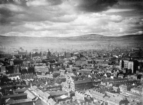
Figure 1.1 Belfast city centre, 1939, looking towards the city hall and the hills beyond.
Source: Courtesy of Belfast Telegraph © National Museums NI Collection Ulster Folk & Transport Museum, ref: BELUM.BT.674.
Despite continuous tension, and flashes of violence in working-class neighbourhoods even before the Troubles, the historic norm in the region had never been one of polarised segregation. Thus, as much as the building of the first separation wall marked a turning point in the urban history of Northern Ireland, the first wall removal represented a credible gesture of reversal in the course of the conflict. It also signals the presence of a resurrection process – a rebirth of sorts, which is emerging at a decisive point in time when practices and processes of cross-community collaboration are beginning to recover the city from its divided and discriminative condition. However complex and long term this process may be, the emergence of new, shared visions, decisions, and collaborations obliges researchers, architects, and urban planners to revisit the theoretical discourse of post-conflict segregation in Northern Ireland and to consider the notion of ‘shareness’ as a new force in practice. We have thus chosen a unique moment in Northern Ireland’s urban history to look at the meanings, processes, and the impact of architecture and spatial memory not only on the city and its fabric but in people’s everyday life as well.
This book presents an open-ended inquiry into the current condition of post-conflict architecture and urbanism in Northern Ireland at a crossroads moment. It aims to confront and challenge the theoretical stereotyping of post-conflict urbanism as a case of division and post-conflict reconciliation. It looks at the contemporary situation from the viewpoint of a shared struggle with the physical and spatial imprints of the past, rather than an engagement with the reality and demands of the present. Putting ordinary people’s everyday life at the centre of our empirical investigation and critical analysis, we look at how people understand, engage with, or benefit from the city at large in Northern Ireland – its architecture, urban spaces, public parks, public squares, and residential areas. We also look at how history and industry have shaped both the cities and villages of Ulster. In the process, we anticipate responding to the following questions: To what extent have the Troubles and its continuous memory determined the predominance of defensive architecture and territorialised urban and civic spaces in Northern Ireland? How do people perceive their cities and urban life, and what determines their use of space and attitudes towards the public, shared, and integrated spaces of the city? And, what constitutes safe or unsafe architectural and urban spaces, buildings, and landscapes for ordinary people?
Why shareness in a divided context
In Ciaran Carson’s poems, maps used to analyse zones, areas, and territories do not reflect the actual life of a city or its urban context. Rather, he advocates that the city should be seen and read through the moments that define the experience of its people in their everyday lives. In the middle of the Troubles, Carson was critical of the absence of discourse reflecting such understanding in a city otherwise defined on maps by barriers, barricades, and other spatial divisions such as the Peace Lines. In Belfast Confetti (1989) Carson stresses,
No, don’t trust maps, for they avoid the moment: ramps, barricades, diversions, Peace Lines.
(Ibid.: p. 58)
The map is pieced together bit by bit. I am this map which they examine, checking it for error, hesitation, accuracy: a map which is this moment, this interrogation, my replies.
(Ibid.: p. 63)
Interestingly enough, this view was not embraced by one side only, and it remains a shared hurdle uniting both communities in a struggle to deal with the involuntary segregation imposed by the Troubles. It is thus through the implicit sublayers of segregation and division, and the unity of hardship, struggle, and unease they impose, that Belfast’s daily life could be traced, mapped, and perhaps written.
Northern Ireland has been extensively researched, investigated, and written about in terms of its peace process, conflict transformation, and post–peace agreement reconciliation. Parliamentary committees, physical and social surveys, policy documents, and planning reports have all pointed to the ethnonational and political division as the underlying condition of Northern Ireland’s modern urbanism. Likewise, a busy calendar of events, venues for expressing identity, and a rivalry of parades, protests, and elections have overshadowed a long history of shared urban development, spatial memory, and architecture. To control hostile altercations between rival communities during the Troubles, beginning in the 1960s, state planning policies implanted industrial estates, infrastructure, and bridges to create buffer zones and barriers, drawing spatial gaps in the city and sectioning it into isolated territories and voids between zones. Narratives of change from an integrated city to one of divided enclaves were also reinforced by security-driven policies that led to undesirable patterns of social engineering. The result today is a multilayered socio-spatial politics in which issues of communication, self-representation, and expression of identity are central to the experience of urban space and architecture and where a spatial dichotomy of division and shared living is a regular feature of everyday life.
As an alternative to taking this condition for granted, we aim here to interrogate instances of public and private intercommunity engagement in the city, as everyday life has continued to produce shared experiences of spaces, buildings, and urban myths over the past two decades. We thus seek to break from the political domain of division to highlight the reality of everyday encounter between local communities within cities and towns across Northern Ireland. We do not therefore accept a condition of division as being the main diver of life in the region since the Troubles. Rather, considering both Contact Theory, through which individuals are seen as identifying themselves as a result of contact with others, and the Birmingham school of Cultural Identity, which perceives identity to be flexible, contextual, and determined by sociocultural factors, we question the state of division as a source of conflict, and we argue that identity was and remains a sociocultural construct that infers inner convictions of ‘Self’ in relation to the ‘Other’ In our perspective, as expressed in this book, conditions of division and conflict are always temporary, whereas shared living and mutual existence are permanent.
To clarify, by the very existence of the physical fabric of separation in Northern Irish cities, the dreadful past continues to influence actions in the present and determine future attitudes. In this sense, the built fabric becomes an object of remembrance that is paradoxical and contested, with different meanings and connotations. The notion of ‘shareness’, however, represents the antithesis of sociopolitical and ethnic division in the practice of everyday life. And we use it here to identify a condition of cognitive belief by an individual or group, in the equal rights of others (those different in racial, ethnic, religious, or cultural backgrounds) to coexist in public space. In this regard, we note that the term share/shared, which reflects the act or action of partaking jointly in activities with others, does not adequately translate the inner conviction of the rightness of such equal representation in public venues. In contrast, shareness communicates coherent social positions and defines the cognitive landscape of the urban experience in a given context. Throughout our research, interviews, and communications with members of various communities in Northern Ireland, we never encountered a situation in which community members denied the rights of others to live in the city or have access to the same services or public spaces they did. It is only through the private micro-urbanism of the community and its boundaries or through political representations of identity, involving such charged symbols as parades, flags, and bonfires, that threats of intrusion typically become matters of significant concern.
In this sense, our argument attempts to offer insights into counternarratives to the physical reality of division by examining the manner in which an urban landscape of shared living remains integral to the spatial practices of ordinary people. We look at spaces, buildings, and towns where both communities come together, and where the dichotomy between ‘division’ and ‘co-existence’ is best displayed. At times, political struggle and myth about the other are inherent in the way individuals use private space for protective acts or public space for defensive ones. Yet, at others, architecture and urban space seem to bring society to a condition of engagement, in which differences are overshadowed by temporal and spatial shared memory. Using the production of space as its central criterion of analysis, the book thus draws on the reality of socio-spatial spheres of engagement transcending space, time, and memory to investigate what makes the Irish condition and how it might serve as a metaphor for the future as a return to the past. In this sense, architecture and urban space are seen as potential agents of coexistence, liveability, and community regeneration. We, of course, look at both sides of the coin – at stories both of success and failure, including examples of urban spaces which, despite being designed for integration, have reinforced a sense of segregation and inequality. Yet we will also examine how architecture and urban planning have the potential to steer the social geography and spatial structure of Northern Ireland toward a more pluralistic condition while downplaying territorial gains and physical segregation.
Consideration of issues of modernity and community development, and of urban architecture and visions of the built fabric as a way to read the socio-spatial conditions of the city, are long overdue in Northern Ireland. Using a comprehensive investigation of socio-spatial practices, architecture, and urban design, we will attempt here to offer an alternative, ideologically and affiliation-free reading of the contemporary spatial condition. The absence of understanding of how people live, communicate, and relate to each other within their private spheres or public spaces leaves much to be uncovered in terms of the potential dimension and meaning of architecture as an agent of change. Indeed, the socio-spatial systems of living and the way these have developed historically and changed throughout the conflict years have yet to be investigated in any volume on the contemporary architecture and urbanism of Northern Irish cities. There is consequently a lack of awareness amongst architects and urban designers of the impact of social memory, spatial patterns, and cultural rituals on the success or failure of their new buildings, developments, or spaces.
Theoretical dispositions
In the post–Good Friday Agreement era, Northern Irish cities have witnessed a growth of spatial politics and an emergence of neoliberal urbanism that has not only reshaped their urban landscapes but also brought new architectural languages, urban management regimes, and new schemes for integration, interface zones, services, and urban containment. Large parts of the current landscape also provide a reminder of past experiences of segregation, division, and contestation, dominant for generations. Yet counternarratives involving the spatial practices of shareness have also developed through mutual living, shared interest, and communal need. To best illustrate such variance, the book utilises an interdisciplinary approach that accounts for sociological, anthropological, and spatial factors in the production and consumption of space by individuals and groups at different periods. How could a building or a public space instil either notions of exclusive identity or attitudes of shared living at different times? An investigation of everyday life experience through narratives of what was, has been, and will be and through interviews and spatial mapping can only build an interpretive bridge over this divide through credible analysis. The book thus approaches the Irish condition from a spatial and architectural standpoint, looking at buildings, spaces (public and private), towns, and various design approaches that have shaped the current built environment. However, it also addresses the impact of the sociopolitical landscape on the experience of the city and the way it may generate peripheries in the centre of the city, or dismantle and reassemble urban communities.
This book is based on extensive research between 2010 and 2017 spanning several projects and design studios. Its purpose is to uncover the notion of shareness as central to understanding architecture and urbanism of cities and towns in Northern Ireland. It expounds this concept through an investigation of the h...
Table of contents
- Cover
- Half Title
- Series
- Title
- Copyright
- Dedication
- Contents
- List of figures
- List of tables
- Acknowledgements
- Author biographies
- Part I The making of the Irish condition
- Part II Architecture and spatial memory in rural and urban environments
- Part III Understanding spatial practice and planning in divided cities
- References
- Index