eBook - ePub
Villa of the Birds
The Excavation and Preservation of the Kom al-Dikka Mosaics
- English
- ePUB (mobile friendly)
- Available on iOS & Android
eBook - ePub
Villa of the Birds
The Excavation and Preservation of the Kom al-Dikka Mosaics
About this book
This fascinating book describes the excavation and preservation of three early Roman villas in Egypt's ancient port city of Alexandria. Chronicling the work of the Polish Archaeological Mission in Alexandria, Villa of the Birds is an engaging and informative account of how these ancient dwellings were unearthed, and how the famous mosaic floors were brought to light two thousand years after they were laid.
With the expert guidance of the archaeologists responsible for the excavation, the reader is led through layers of clues reaching ten meters below today's street level, and to an in-depth appreciation of this extraordinary site's rich history.
Drawing directly on their work with the Polish Archeological Mission, the authors describe in detail the excavation of the housing areas, as well as the baths, the gymnasia, and the theater that comprise the villa complex.
Villa of the Birds reconstructs not only the villas themselves, with their magnificent mosaics, but also the history of how they were built and used, and ultimately how they were destroyed by fire. The book is richly illustrated with detailed floor plans as well as spectacular color photographs of the mosaics themselves.
American Research Center in Egypt Conservation Series 3
Trusted by 375,005 students
Access to over 1.5 million titles for a fair monthly price.
Study more efficiently using our study tools.
Information
Topic
ArchitectureChapter 1
Archaeological
Research Work
Research Work
Topography
The site of Kom al-Dikka is situated in the very center of modern Alexandria, next to the main Masr railway station (Fig. 1). Several centuries of accumulated deposits turned this area into a mound, which was raised and modified in the Napoleonic era when a fort was erected on the hill. The site has piqued the interest of archaeologists for a long time, but the first, very limited, excavations at the end of the nineteenth century brought meager results. Later work on the outskirts of the hills was limited to an exploration of the Medieval layers.1 Regular excavations became possible in the late 1950s after the hill had been leveled. The site, which covers some 40,000 square meters, has been investigated uninterruptedly since 1960 by the Polish Centre of Archaeology in Cairo in close cooperation with Egypt’s Supreme Council of Antiquities. As a result of these excavations, an extensive section of ancient Alexandrian town architecture was uncovered, including several well-preserved monuments, mainly dating from the Late Roman/Byzantine period (fourth to seventh centuries AD).
The excavation area covers the central part of an insula (ancient Roman building or a group of buildings standing together forming a block or square) located in the city center, a town block that had adjoined, to its north, the main east–west street conventionally referred to as Via Canopica. The western face of this block reached the main north–south street R5, which runs toward the sea; on the south, it was bordered by street L2 and on the east by street R4.2 The course of these streets is known from archaeological excavations carried out in other parts of the city. In the fourth century AD, a wide passage, which the excavators have called a Theater Portico, was traced across the insula, thus providing the main north–south axis for the entire complex of public buildings raised in this period.
The complex is dominated by the imperial baths, with their gymnasia taking up practically half of the archaeological zone.3 In the southwestern end of the zone, there is a very well preserved theater that adjoins the portico. The remainder of the area is occupied by a cistern, public lavatories, auditoria, and stores.4 In the 1970s and later in the 1990s, explorations carried out east of street R4 revealed parts of a residential district from the Late Roman/Byzantine period (fourth to seventh centuries AD), including a number of buildings (designated A–H) combining habitation functions with commercial and industrial purposes.5 A sizable part of this architecture was restored and now constitutes a permanent element of the open-air exposition (Fig. 3).
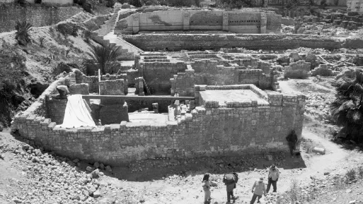
Fig. 2: General view of the shelter location before the commencement of work, looking west.
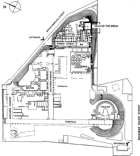
Fig. 3: General plan of the Kom al-Dikka site. (Drawing by W. Kołątaj)
Below the Late Roman/Byzantine buildings, ruins of earlier residential architecture dating to the Early Roman period (first to third centuries AD) were found throughout this area. The site has suffered from systematic pilfering for building material over the ages. Only in the western part of the area have fragments of three urban villas been preserved over a greater surface (designated alpha, beta, and gamma respectively). Despite extensive destruction of the actual buildings, the mosaic pavements decorating the floors in these villas have survived in relatively good condition. The set of mosaic floors excavated includes several examples of different classes and sizes. For a number of reasons—such as their belonging to a single structure, their relatively good condition, and the elements of the surrounding topography—only the four mosaics decorating building alpha (also called the Villa of the Birds) were chosen as the focus of the present conservation project.
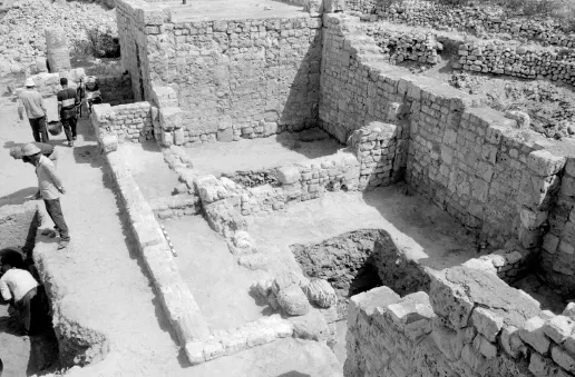
Fig. 4: Late Roman/Byzantine Building B, looking north.
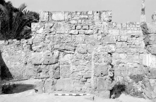
Fig. 5: East wall of Building F, looking west.
Villa alpha is situated at the eastern end of the excavation area, some thirty meters east of street R4, directly under the Late Roman/Byzantine Buildings B and F. The whole residential district is located some eight or nine meters below the modern ground level. Its borders on the east (modern Safiya Zaghloul Street) and south (fire brigade premises) are comprised of steep escarpments shaped in the course of the excavations, thus there is no way that the work could be extended further. Furthermore, the site is endangered by rainfall running down the artificial escarpment slopes.
Summary of the Excavations
It was essential to carry out archaeological excavations prior to undertaking both the conservation and construction work. The investigations covered an area of some 200 square meters occupied by the Late Roman/Byzantine Buildings B and F together with an interior courtyard and the underlying ruins of House alpha. The schedule anticipated a number of work stages, the principal of which started on May 1, 1998 and was completed by July 15 of the same year. This stage involved the full clearing of the mosaic floors and preparation for their conservation. The need to adjust the excavation work to the conservation and construction schedules, as well as new discoveries made over the course of the project (mosaic α-6), necessitated additional work at a later date (January–February 1999).
The first step was to identify the extent of the area and to clear the trenches from excavations carried out in the 1970s. The fieldwork at that time was carried out in incomparably less comfortable conditions, in exceptionally deep trenches reaching in some places a precarious depth of 8 meters below ground level. Most of the work was done in narrow trenches dug in a number of different places, their position determined by the extant remains of Late Roman/Byzantine Houses B and F. Despite these limitations, large fragments of the mosaic floors were uncovered and basic chronological determinations made. Unfortunately, it was impossible at the time to reveal the full extent of the floors, and the architectural context was not completely recognized either. There was thus no opportunity to prepare a plan of the layout or functional arrangement of the building. Following a provisional protection of the mosaics, the trenches were filled in 1974.
The strategy of the present excavation was to some extent imposed by the general work plan of the project. The principal objective was to clear the entire set of mosaic floors intended for conservation. Furthermore, the character of the work required a better understanding of the plan of Villa alpha, including tracing the course of the walls and identifying the functions of particular rooms. Another vitally important objective was to collect more evidence for the chronology of the building itself and each of the mosaic floors.
The present work made use of topographical designations introduced in the 1970s. For the sake of clarity, particular rooms were numbered after the mosaic floors decorating them, for example mosaic α-4 in Room 4. A set of stratigraphical context numbers was assigned for documentation purposes. The small-finds register (pottery, coins, oil lamps, etc.) was part of the general site register and followed the rules set down for it.
Late Roman/Byzantine Buildings B and F
In keeping with the project objectives, the first stage of the present work was devoted to exploring the uppermost accumulations, approximately 1.10–1.30 meters thick, from the Late Roman/Byzantine period, which were integrally connected with the building and occupation of Houses B and F. These two structures, located in the eastern end of the Habitation Quarter, had been uncovered practically in their entirety and investigated in the 1970s (Fig. 6).
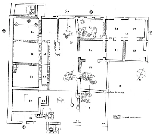
Fig. 6: Plan of the Late Roman/Byzantine Buildings B and F. (Drawing by W. Kołątaj)
Rodziewicz ascertained that Building B, p...
Table of contents
- Cover
- Halftitle Page
- Series Page
- Title Page
- Copyright
- Contents
- Illustrations
- Introduction
- 1. Archaeological Research Work Grzegorz Majcherek
- 2. Mosaics Conservation Work Ewa Parandowska
- 3. Architectural and Functional Assumptions Wojciech Kolątaj
- 4. The Shelter Design Wojciech Kolątaj
- Glossary
- Notes
- Bibliography
- Index
Frequently asked questions
Yes, you can cancel anytime from the Subscription tab in your account settings on the Perlego website. Your subscription will stay active until the end of your current billing period. Learn how to cancel your subscription
No, books cannot be downloaded as external files, such as PDFs, for use outside of Perlego. However, you can download books within the Perlego app for offline reading on mobile or tablet. Learn how to download books offline
Perlego offers two plans: Essential and Complete
- Essential is ideal for learners and professionals who enjoy exploring a wide range of subjects. Access the Essential Library with 800,000+ trusted titles and best-sellers across business, personal growth, and the humanities. Includes unlimited reading time and Standard Read Aloud voice.
- Complete: Perfect for advanced learners and researchers needing full, unrestricted access. Unlock 1.5M+ books across hundreds of subjects, including academic and specialized titles. The Complete Plan also includes advanced features like Premium Read Aloud and Research Assistant.
We are an online textbook subscription service, where you can get access to an entire online library for less than the price of a single book per month. With over 1.5 million books across 990+ topics, we’ve got you covered! Learn about our mission
Look out for the read-aloud symbol on your next book to see if you can listen to it. The read-aloud tool reads text aloud for you, highlighting the text as it is being read. You can pause it, speed it up and slow it down. Learn more about Read Aloud
Yes! You can use the Perlego app on both iOS and Android devices to read anytime, anywhere — even offline. Perfect for commutes or when you’re on the go.
Please note we cannot support devices running on iOS 13 and Android 7 or earlier. Learn more about using the app
Please note we cannot support devices running on iOS 13 and Android 7 or earlier. Learn more about using the app
Yes, you can access Villa of the Birds by Wojcech Kolataj,Grzegorz Majcherek,Ewa Parandowska in PDF and/or ePUB format, as well as other popular books in Architecture & Historic Preservation in Architecture. We have over 1.5 million books available in our catalogue for you to explore.