Elis examines the city of Elis from its earliest history, through the Archaic period and the Classical period where it reached its zenith, to its decline in the Hellenistic, Roman and later periods. Through examining this prominent city-state, its role in contemporary politics and the place of Olympia in its territory, Graeme Bourke allows the reader to explore broader issues, such as the relationship between the Spartans and their various allies, often collectively referred to as 'the Peloponnesian League', the connection between political structures and Panhellenic sanctuaries, and the network of relationships between various ancient sanctuaries throughout the Greek-speaking world. The volume, which makes available in English for the first time much of the debate about the city, provides a valuable resource for students and academics studying the city of Elis, the Peloponnese and the relationships within it, and pre-Hellenistic Greece as a whole.
- 248 pages
- English
- ePUB (mobile friendly)
- Available on iOS & Android
eBook - ePub
About this book
Trusted by 375,005 students
Access to over 1.5 million titles for a fair monthly price.
Study more efficiently using our study tools.
Information
p.5
1 The land and its people
Ancient Eleia
From the high country of Arkadia, the heart of the Peloponnese, several mountain ranges extend towards the sea, delineating various lowland regions, such as Argolis, Lakonia, Messenia and, in the north-west, Eleia. It has been pointed out, however, that our image of the Peloponnese ‘hanging like a mulberry leaf from the stalk of Corinth’ is not that of the ancients, and to Philip V of Makedon as he invaded it late in the third century BC the Peloponnese ‘was surely no two-dimensional outline on a horizontal map-table, but a mental or visual image occupying his actual and mental gaze at eye level’.1 The gaze of most inhabitants of and visitors to the peninsula did not always need to be as acute and far-reaching as that of the military dynast striving to dominate its diverse regions. We can, nevertheless, gain a useful understanding of the topography of the particular region with which this work is concerned by considering how it must have appeared to ancient travellers entering through various portals: the coastal gateways from the south and north; the passes down from the highlands of Arkadia; and the seaports.
Those who came from Messenia in the south entered the region by crossing the River Neda, which flowed westward from the mountains of south-western Arkadia towards the Ionian Sea (Map 1.1).2 Because of the rugged nature of the terrain through which the Neda flowed, it could easily be crossed only at its mouth or near its source.3 After fording this river, travellers could continue northward along the coast, with the valleys formed by the western spurs of Mount Minthe (Alvena) on their right, the sea close by on their left and the great east-west ridge of Mount Lapithas (Smerna) rising ever more prominently before them as they advanced (Figure 1.1). The country between the lower Neda and this imposing (though not trackless) barrier constituted a distinct geographical entity, which, since Lepreon was its most important ancient community, we may call ‘Lepreatis’. Travellers who entered the region from the south would then have followed the coastal road north-westward until they reached the point where the western extremity of Lapithas, extending almost to the sea, rose steeply on their right. In Leake’s time, here was located ‘a Dervény, or guarded pass, at the foot of a steep rocky point, projecting to the sea from the mountain of Smerna’.4 Emerging from this pass and thereby leaving Lepreatis, travellers could either turn inland through the hilly country between Mount Lapithas and the River Alpheios or else continue along the coast until they reached the ford near the mouth of that stream.5 They might then either turn right and follow the Alpheios valley into the interior or proceed north-westward along the coastal plain with hilly, forested country on their right until they reached the wide, open and fertile plain of the Peneios, the most extensive in the Peloponnese.
p.6
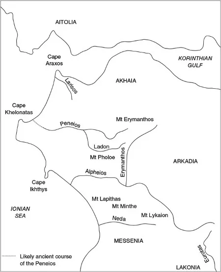
Map 1.1 Eleia: principal physical features and neighbouring regions. Created by the author.
p.7
Travellers who took the coastal route into Eleia from the most northerly region of the Peloponnese, Akhaia, crossed the River Larisos (Mana), which flowed down from the westerly reaches of the great, multi-peaked mass of Mount Erymanthos/Olonos.6 With these high mountains visible on their left, they continued southward into the plain of the Peneios.7 The Larisos itself presented little impediment, but the district surrounding it may well have been covered, as in the nineteenth century AD, by an extensive forest of oak.8
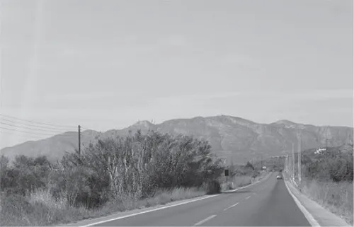
Figure 1.1 Looking northward from the E55 towards Mt Lapithas. Photo courtesy of the author.
It was also possible to enter Eleia from the interior of the Peloponnese, using one of two major routes. The first of these led travellers south-westward through the precipitous landscape of north-western Arkadia, with Mount Lampeia on their right and beyond it the ‘formidable obstacle’ of the long ridge of Mount Erymanthos (Figure 1.2).9 Below to their left flowed the upper reaches of the Erymanthos River, which continued southward until it met the Alpheios and, since both its banks rose steeply for much of its course, constituted ‘the natural boundary’ between Eleia and Arkadia.10 Travellers following this route turned westward after a time, away from the gorge of the Erymanthos and through forested country to meet the left bank of the River Ladon, a tributary of the Peneios.11 From this point it was possible to either continue westward along the Ladon towards the plain of the Peneios or turn south-westward across the terraced plateau of Mount Pholoe (Kapellis),12 stretching from the steep gorge of the Erymanthos River in the east to about halfway to the sea in the west, and thus descend along the course of the Kladeos into the Alpheios valley.13
p.8
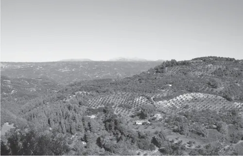
Figure 1.2 Looking northward from the likely site of ancient Makiston across the Alpheios valley and the Pholoe plateau to Mt Erymanthos. Photo courtesy of the author.
The other major route from Arkadia into Eleia, leading down from south-western Arkadia directly into the Alpheios valley, constituted the most common means of entering the region from the inland of the Peloponnese. The Alpheios sprang from the same district of southern Arkadia as the Eurotas, the river of Sparta, and these streams flowed in generally opposite directions along the most significant furrow in the Peloponnese. Travellers into Eleia from central or southern Arkadia and beyond followed the course of the Alpheios, crossing the River Erymanthos into Eleian territory near the confluence of these streams (Figure 1.3). They could then either continue along the right bank of the Alpheios or take what appears to have been the more direct route, crossing the river as it made a northward turn about 10km downstream from its confluence with the Erymanthos and then re-crossing it just below its confluence with the Kladeos.14 Those who used this route into Eleia might also cross the Alpheios just below the Erymanthos and, turning south-westward, pass between Mounts Lapithas and Minthe in order to enter Lepreatis.15
p.9
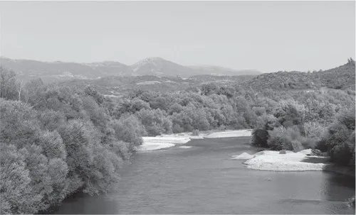
Figure 1.3 Looking eastward towards the confluence of the R. Erymanthos with the R. Alpheios from the present-day bridge over the Alpheios. Photo courtesy of the autho...
Table of contents
- Cover Page
- Elis
- Cities of the Ancient World
- Title
- Copyright
- Praise
- Contents
- List of Figures
- List of Maps
- Acknowledgements
- List of Abbreviations
- Introduction
- 1 The Land and its People
- 2 Communities and sanctuaries
- 3 The Question of Pisa
- 4 Archaic Political Events
- 5 Synoikism and Democracy
- 6 External Relations to 422 BC
- 7 Between the Arkhidamian and Dekeleian Wars
- 8 The Eleian War
- 9 The Early Fourth Century BC
- 10 The Middle Fourth Century BC
- 11 A new context (338–222 BC)
- 12 Resistance and subjection (221–146 BC)
- Conclusion
- Index
Frequently asked questions
Yes, you can cancel anytime from the Subscription tab in your account settings on the Perlego website. Your subscription will stay active until the end of your current billing period. Learn how to cancel your subscription
No, books cannot be downloaded as external files, such as PDFs, for use outside of Perlego. However, you can download books within the Perlego app for offline reading on mobile or tablet. Learn how to download books offline
Perlego offers two plans: Essential and Complete
- Essential is ideal for learners and professionals who enjoy exploring a wide range of subjects. Access the Essential Library with 800,000+ trusted titles and best-sellers across business, personal growth, and the humanities. Includes unlimited reading time and Standard Read Aloud voice.
- Complete: Perfect for advanced learners and researchers needing full, unrestricted access. Unlock 1.5M+ books across hundreds of subjects, including academic and specialized titles. The Complete Plan also includes advanced features like Premium Read Aloud and Research Assistant.
We are an online textbook subscription service, where you can get access to an entire online library for less than the price of a single book per month. With over 1.5 million books across 990+ topics, we’ve got you covered! Learn about our mission
Look out for the read-aloud symbol on your next book to see if you can listen to it. The read-aloud tool reads text aloud for you, highlighting the text as it is being read. You can pause it, speed it up and slow it down. Learn more about Read Aloud
Yes! You can use the Perlego app on both iOS and Android devices to read anytime, anywhere — even offline. Perfect for commutes or when you’re on the go.
Please note we cannot support devices running on iOS 13 and Android 7 or earlier. Learn more about using the app
Please note we cannot support devices running on iOS 13 and Android 7 or earlier. Learn more about using the app
Yes, you can access Elis by Graeme Bourke in PDF and/or ePUB format, as well as other popular books in History & Ancient History. We have over 1.5 million books available in our catalogue for you to explore.