- 242 pages
- English
- ePUB (mobile friendly)
- Available on iOS & Android
eBook - ePub
Geomorphology: Pure and Applied
About this book
This unique treatment of geomorphology, first published in 1986, provides a comprehensive work to enable students to see the subject as a whole. Taking the concepts that run through the subject and cut across its standard divisions, the book summarises the history of intellectual debate in geomorphology and then describes modern developments, both pure and applied.
Tools to learn more effectively

Saving Books

Keyword Search

Annotating Text

Listen to it instead
Information
PART I
The history of geomorphology
1 The history of geomorphological debate in the pre-Davisian era
Introduction
The origins of geomorphology are obscure. The term itself was developed by geologists, probably WJ McGee and J. W. Powell, in the United States in the 1880s. Therefore, in the pre-Davisian era there was no science called geomorphology, but there were developments in geology and natural science that we can now recognise as early geomorphological thought. They are described in detail by Chorley et al. (1964).
Aristotle, the Greek philosopher and natural scientist, had several ideas that ring true today. For example, he conceived clearly the concept of a meteorological cycle, although curiously he applied it to the formation of water within the Earth. He observed that some streams resulted from the downward percolation of rainwater, although he could not believe that there was enough rain for all streams all the time. He also appreciated that streams carved the surface of the Earth and made the landscape.
Catastrophism
Such sound ideas played little part, however, in the mainstream of scientific thought during the Middle Ages (1066–1536). The source of water was thought to be beneath the earth, supplied from the oceans. Moreover, during these centuries biblical beliefs held sway: the basic idea was that the Earth had been shaped during a very short period of time, the six days of the Creation and the 40 days of Flood. Adherents to such a view were called ‘catastrophists’ or ‘cataclysmysts’. There was even some degree of confidence over the timing of the event, for Dr John Lightfoot, Vice-Chancellor of Cambridge University, claimed in 1654 that ‘Heaven and Earth … and clouds full of water and man were created by the Trinity on 26 October 4004 BC’. According to the catastrophists, therefore, the Earth was about 6000 years old.
There were dissenters, however; not all scientists were catastrophists. For example, as early as the Renaissance (the 15th and early 16th centuries) engineers such as Leonardo da Vinci (1452–1519) and Bernard Palissy (1510–90) recognised the slow rate of operation of geomorphological processes. Palissy asserted that springs were fed by rain alone, but he did not convince natural scientists in general. But he also showed how it happened, giving a clear account of what we would now call the hydrological cycle. Leonardo was convinced that rivers erode their beds and thus excavate valleys. But his ideas remained unpublished until the end of the 18th century, they were not communicated to anyone, and they had little or no influence on the development of scientific thought. In fact, catastrophism remained important until the mid-19th century. In the meantime it is interesting to note that contemporary ignorance of the way in which rivers cut their valleys helps to explain the rather improbable river courses shown on medieval maps such as the 14th-century Mappa Mundi, now on display in Hereford Cathedral (Fig. 1.1). It is also perhaps significant that notions on gravity and its role were still rather vague. Newton’s famous work came much later, in 1687.
We now enter a rather curious period, from the end of the Middle Ages to about the end of the 18th century, in which many valuable advances were made but which did not influence the consensus of scientific opinion regarding catastrophism. Most of the advances were made by practising engineers, and most of the engineers were French. In 1674 Pierre Perrault, working on the Seine basin, proved what Palissy had always maintained, that precipitation was adequate to sustain streamflow. In 1755 Euler founded the science of hydromechanics and stated its basic principles. In 1775 DeChézy proposed a formula for streamflow that is still in use today. During the 18th century, Lamblardie attempted to measure the drift of pebbles along the coast of the Pays de Caux in order to estimate the amount of dredging necessary to maintain small ports, and du Boys showed that a relationship existed between the size of particles carried by a river and the velocity of the current. The tradition of French engineers was continued early in the 19th century by Surell (1841) who, faced with the practical problems of the construction and maintenance of roads in the Alps, drew up a valid theory of fluvial erosion that included the concepts of base level and equilibrium profile. However, all these immensely practical findings by a small number of technicians had little impact on academic geomorphology. It is curious to reflect, in view of the importance attached today to the ‘new’ applied geomorphology, that the origins of the subject lie with practical engineers whose work was not embodied into the assemblage of knowledge at the time.
Meanwhile, also during the 18th century, some natural scientists were developing thoroughly the idea of stream sculpture. For example, Guettard’s work in the Paris Basin and the Massif Central and his paper on the degradation of mountains dealt with the erosive ability of running water, and Desmarest traced the history and development of a landscape in the Auvergne, showing that the valleys were formed by the streams that still occupy them. Then, towards the end of the 18th century, we see academic geomorphology being born out of geology. De Saussure, for example, working in the Alps, saw that the valleys and drainage systems of the region were very closely related to each other, and he also saw fossil shells on mountain summits and doubted the concept of crustal stability. We can say that academic geomorphology derived from geology because de Saussure and other early geologists were the first of a long line of geologists who appear in the story shortly: Hutton, Lyell, Powell, Gilbert, even Davis himself.
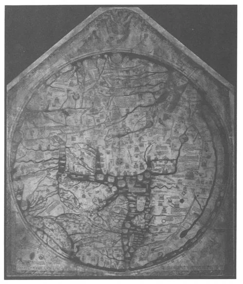
Figure 1.1 The 14th-century Mappa Mundi in Hereford Cathedral (from Brunsden & Doornkamp 1977).
However, that comes later. For the moment we stand at the end of the 18th century, and scientific opinion in general was still dominated by catastrophism. Indeed, the idea was still being verified and developed. In 1761 Alexander Catcott had described an experimental scale model in which he simulated the erosive potential of the Flood. So in 1800 it was not generally recognised that rivers cut valleys. Indeed, the very concept of the valley was a confusing one. Every depression was labelled as such, and for some even the Atlantic was a valley. Valleys pre-dated the rivers in them, so streams flowed in valleys because the valleys were there already. (In view of the fact that such notions were soon to be dispelled, it is interesting to consider that today that would be seen as a very reasonable view of present-day misfit streams flowing in oversize valleys or present-day streams flowing in glacial troughs.) We must also be clear that at the end of the 18th century there was no clear distinction between igneous and sedimentary rocks, geological time was still measured in thousands of years, and the erosional capacity of the sea and glaciers was appreciated no better than that of rivers.
Forty years later, by 1840, catastrophism had been refuted. The overthrow of this long-standing belief came in two stages: the appearance of the concept of uniformitarianism, and the rise of the Glacial Theory. In retrospect it can be seen as nothing less than a revolution in scientific thought.
Uniformitarianism
Uniformitarianism, often summarised by the little dictum ‘the present is the key to the past’, says that the processes and natural laws which existed in geological time are basically the same as the ones that may be observed in the landscape today. It follows that landforms have been formed by present-day processes operating slowly over long periods: the exact antithesis of catastrophism.
Uniformitarianism was initiated and established by Hutton (1726–97), a Scottish geologist, in his Theory of the Earth published in 1788. The concept was later persuasively argued and formally presented to the scientific community by Lyell (1797–1875) also a Scot and also a geologist (Fig. 1.2), in the highly successful Principles of geology (1830), which went through several editions. As geologists, they were aware of the unconformities in the English coalfields and they realised that mountains had been formed and levelled before the deposition of later strata. Lyell went on to describe precisely how processes disintegrate rocks, remove their debris by running water, destroy mountains in the long run, and lay down sediments from which the next generation of mountains will be built. There was also a third advocate of uniformitarianism, Playfair (Fig. 1.2) who published his Illustrations of the Huttonian theory of the Earth in 1802. In it are the main outlines of the concept of the drainage network, including the hierarchy of streams and a statement of ‘Playfair’s Law’ which says that in areas of uniform bedrock and structure that have been subject to river erosion for a long time, valleys are proportional in size to the streams they contain, and stream junctions in these valleys are accordant.
At much the same time as the concept of uniformitarianism was being developed, it was becoming clear that the Earth was much older than the 6000 years proposed by the catastrophists. Indeed, the two ideas go together. The development of thought between about 1750 and 1850, during which the geological timescale was completely revised, is described in detail by Toulmin and Goodfield (1965). During the 1770s there were various attempts by scientists, notably that of Buffon, to apply Newton’s new laws of physics to the problem of the age of the Earth. As it happens, Buffon totally underestimated the impact of radiant heat from the Sun on the rate of cooling of the Earth, and so his estimate of 168 000 years was a long way from the mark. Nonetheless, such ideas pointed the way forward. Hutton made it clear that the slow operation of geological processes required long time-periods, but he observed that geology proved nothing about the origin of the Earth (‘… no vestige of a beginning …’). William Smith, the so-called father of stratigraphy, established the twin principles of superposition of strata and correlation of strata by fossils and thus further demonstrated the antiquity of the Earth. Lyell finally confirmed that geological time was more or less unlimited, although no actual numbers were mentioned. Toulmin and Goodfield speak of ‘… Lyell’s final breaching of the time-barrier …’ (ibid., p. 171). The importance of this demonstration by scientists that the Earth is very old must not be underestimated: geomorphology could not have developed without it. Of course, the story goes on. Darwin’s (1859) Origin of species implied long time-periods for man’s existence, let alone the Earth’s (and also, incidentally, with his theory of evolution, set the stage for Davis’s evolutionary concepts on landforms), and modern radioactive dating techniques now show the Earth to be about 4500 million years old.
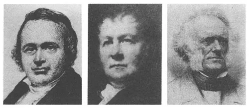
Figure 1.2 (left to right) Charles Lyell, John Playfair and Louis Agassiz (from Brunsden & Doornkamp 1977).
However, that is to digress from early 19th-century thought on uniformitarianism. It might be thought that the concept, thus argued by three prominent men (Hutton, Playfair and Lyell), would have forced the scientific community to discard catastrophism. But it didn’t. For example, as late as 1815 the Niagara gorge was stated to have been formed by a dreadful catastrophe, and well into the 19th century many geologists were ascribing gorges in general to folding and faulting rather than to stream erosion. There were reasons why uniformitarianism was not accepted immediately: there were dry valleys in southern England with no rivers, in the Alps there were many examples of hanging valleys whose confluences with the main valleys were obviously not accordant, and there were lakes in many Alpine valleys. Another argument used against uniformitarianism was the existence of erratics and other superficial deposits that were supposed to have been distributed by so-called ‘waves of translation’. Thus, although looking back we can now see that uniformitarianism ‘replaced’ catastrophism, the final death knell of catastrophism was sounded only several years later by the rise of a quite different branch of geomorphology – glaciation.
The Glacial Theory
Descriptions of glaciers can be found in 11th-century Icelandic literature, but the fact that they move does not appear to have been noticed, or at any rate recorded, until about 500 years later. In 1723 Scheuchzer put forward a theory of glacier movement: he suggested that water entered crevasses and froze, causing the ice to move downhill. By 1751, in the work of Altmann, we can see that it was recognised that gravity was the cause of ice motion. Later in the same century, de Saussure understood the formation, movement and some of the effects of glaciers, especially their ability to transport large boulders. By 1815, in the writings of Perraudin, a Swiss guide, the idea that the i...
Table of contents
- Cover
- Half Title
- Title Page
- Copyright Page
- Table of Contents
- Preface
- Introduction
- Part I The history of geomorphology
- 1 The history of geomorphological debate in the pre-Davisian era
- Part II The historical approach in geomorphology
- 2 William Morris Davis: the geographical cycle of erosion
- 3 Other applications of the cycle concept
- 4 The response in Britain to the cycle: denudation chronology
- 5 The Continental response to Davis’s cycle
- 6 Pleistocene geomorphology: the impact of environmental change
- Part III Modern pure geomorphology
- 7 Form
- 8 Process
- 9 Materials
- 10 Methods of analysis
- Part IV Modern applied geomorphology
- 11 Background to applied studies
- 12 Environmental hazards
- 13 Environmental management
- 14 Resource evaluation
- Part V The current conceptual status of geomorphology
- 15 Pure and applied geomorphology in context
- Bibliography
- Subject index
- Index of place names
Frequently asked questions
Yes, you can cancel anytime from the Subscription tab in your account settings on the Perlego website. Your subscription will stay active until the end of your current billing period. Learn how to cancel your subscription
No, books cannot be downloaded as external files, such as PDFs, for use outside of Perlego. However, you can download books within the Perlego app for offline reading on mobile or tablet. Learn how to download books offline
Perlego offers two plans: Essential and Complete
- Essential is ideal for learners and professionals who enjoy exploring a wide range of subjects. Access the Essential Library with 800,000+ trusted titles and best-sellers across business, personal growth, and the humanities. Includes unlimited reading time and Standard Read Aloud voice.
- Complete: Perfect for advanced learners and researchers needing full, unrestricted access. Unlock 1.4M+ books across hundreds of subjects, including academic and specialized titles. The Complete Plan also includes advanced features like Premium Read Aloud and Research Assistant.
We are an online textbook subscription service, where you can get access to an entire online library for less than the price of a single book per month. With over 1 million books across 990+ topics, we’ve got you covered! Learn about our mission
Look out for the read-aloud symbol on your next book to see if you can listen to it. The read-aloud tool reads text aloud for you, highlighting the text as it is being read. You can pause it, speed it up and slow it down. Learn more about Read Aloud
Yes! You can use the Perlego app on both iOS and Android devices to read anytime, anywhere — even offline. Perfect for commutes or when you’re on the go.
Please note we cannot support devices running on iOS 13 and Android 7 or earlier. Learn more about using the app
Please note we cannot support devices running on iOS 13 and Android 7 or earlier. Learn more about using the app
Yes, you can access Geomorphology: Pure and Applied by M.G. Hart in PDF and/or ePUB format, as well as other popular books in Physical Sciences & Ecology. We have over one million books available in our catalogue for you to explore.