The book provides a comprehensive insight into watersheds and modeling of the hydrological processes in the watersheds. It covers the concepts of watershed hydrology and watershed management in depth. The basic types, of soil erosion and its measurement and estimation of runoff and soil loss from the small and large watersheds are discussed. Recent advances in the watershed management like the application of remote sensing and GIS and hydrological models are a part of the book. The book serve as a guide for professional and competitive examinations for undergraduate students of Agriculture and Agricultural Engineering and graduate students of Soil Science, Soil and Water Engineering, Agricultural Physics, Hydrology and Watershed Management.
Department of Soil and Water Engineering, Punjab Agricultural University, Ludhiana, India. Email: [email protected]
Introduction
Water is the most abundant substance on earth upon which all life on earth is dependent. Hydrology deals with the earth’s water in all its phases and is therefore a subject of great importance to society for the creation of liveable environment. Human activities such as cultivation on terraced lands, clearing of forests for different purposes, construction of roads, mining, over exploitation of groundwater, dumping wastes into rivers and reservoirs, and application of high fertilizer doses for achieving higher yields, etc., changes the pattern of distribution and circulation of earth’s water. As every inhabitant living on the earth belongs to a particular watershed, they are continuously influencing quantity/availability and quality of water by their actions, and the use of water. The protection, conservation, and management of water resources and water quality depend upon all of us understanding the basic concepts of hydrology as well as that of watershed and watershed health. To do so the understanding of the hydrologic cycle is very important.
Hydrologic Cycle
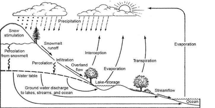
We know that earth’s water is always in movement. The natural water cycle that describes the continuous movement of water on, above, and below the surface of the earth is known as the hydrologic cycle. There is an endless circulation of water on the earth, linking oceans, land surface and atmosphere. The hydrologic cycle as shown in Fig. 1, describes the processes by which water moves around the globe. It begins with the evaporation of water from the ocean which then forms moist air masses. As moist air is lifted, it cools and water vapours condense to form clouds. Moisture is transported in the atmosphere by air currents towards land surfaces around the globe until it returns as precipitation over the earth surface. While falling over the earth a part of precipitation is intercepted by the vegetation and man-made structures. The water that eventually reaches the ground, a part of it may evaporate back into the atmosphere or it may infiltrate into the soil and percolate to become groundwater. Groundwater either seeps its way into the rivers, streams, and oceans, or is released back into the atmosphere through evaporation and transpiration. The balance amount of water that remains on the earth’s surface is runoff, which flows and empties into lakes, rivers and streams and is carried back to the oceans, where the cycle starts again (Pidwirny 2006). Hence, the major components of the hydrologic cycle are: Precipitation—rain, snow, hail, sleet, dew, drizzle, fog, etc.; Evaporation and transpiration; Interception, depression storage, infiltration, percolation and seepage; Surface runoff, sub-surface runoff or interflow and groundwater or base flow; and water storage over and below the land surface including water stored in the soil profile.
From a global perspective, the hydrologic cycle can be considered to be comprised of four major systems as can be seen in Fig. 1., the Hydrosphere is the source of water, the Atmosphere is the deliverer of water, and the Lithosphere and the Biosphere are the users of water. The hydrologic cycle is indeed a natural machine run by solar energy and the gravitational forces with water as the material process. There is no gain or loss of water in the cycle. That means the total amount of water on the planet and its atmosphere remains same, but is continuously changing from one state to another and is moving at different speeds through different paths. The water falling on earth surface follows different routes on its way back to the ocean. The shortest leg of this journey is the water falling directly into the ocean. The longest leg of journey is probably the water infiltrating into the land surface and percolating down to join the groundwater, which eventually flows to the streams as spring flow and finds its way back to the ocean.
Fig. 1. Hydrologic cycle (Source: Gregory et al. 2012).
Hydrology and Watershed
The science which deals with water and its movement in the hydrologic cycle is known as hydrology. That means it deals with occurrence, circulation and distribution of water from the earth and earth’s atmosphere. It is concerned with the water falling as precipitation on land surface, water in the streams, lakes and reservoirs, soil and rocks below the earth’s surface. From an application point of view hydrology deals with occurrence, movement, distribution, circulation, storage, use, development and management of water. Traditionally, hydrology is divided into two main branches: surface water hydrology, and groundwater hydrology. Surface water hydrology deals mainly with water on the earth’s surface, whereas groundwater hydrology deals with the water below the earth’s surface. However, groundwater may appear as surface water or vice versa. Hydrology, which treats all phases of earth’s water, is a subject of great importance for the inhabitants of the earth and their environment. Hydrologic knowledge helps us to solve water-related problems: the problems of quantity, quality and availability within a hydrologic unit known as a watershed.
A watershed is defined as the area above a certain point which drains water through that particular point, i.e., outlet. In other words, it is an area of land which drains or sheds all of the incoming excess precipitation at the same place, toward the same body of water or the same low elevation area resulting from its topography. This means that a watershed’s boundary is defined by its topographic high points. The precipitation that falls within the boundary of a watershed would flow as excess precipitation towards its outlet, i.e., point of lowest elevation. Depending on the location of the outlet, the watershed area would be different. A watershed is fairly simple to identify in hilly areas because its boundaries are well defined by ridges. However, in flatlands such as the alluvial plains, identifying topographic high points may be quite challenging because the highest and lowest elevations may have a difference of only a few centimeters. At all points on the earth’s surface, even where there is no evidence of surface runoff flow, a watershed does exist. This is because a difference in elevations exists everywhere, and when rainfall occurs, even if it is infrequent, the topographical features of the watershed will determine where runoff water will accumulate and flow. Also, all the drainage lines are located on low points on the land where surface runoff accumulates and flow. The size of a watershed depends on the location of the outlet and it is largest when the streams or river of that watershed discharges directly into an ocean. In that case the watershed might be referred to as a river basin and the rivers involved in such cases generally used to be perennial rivers. A river basin or a large watershed or catchment includes a number of small watersheds within its boundary, each draining runoff into the same river. Watershed or river basin boundaries do not respect district or state boundaries determined by political considerations.
Scales in Hydrology
Depending on a given hydrologic problem and the situation, the hydrologic cycle or its component processes can be assumed to vary at different scales of space and time.
Spatial scales
From the point of view of hydrologic studies, the three spatial scales are readily distinct. These are the global scale, the river basin scale and the watershed scale. The global scale is the largest scale and the watershed is the smallest spatial scale.
Hydrologic study at the global scale is necessary to understand the global fluxes and global circulation patterns. The global hydrologic study can be considered to be comprised of three major systems namely the oceans, the atmosphere, and the land surfaces. The principal processes that transmit water from one system to another are required to be considered. These are precipitation, runoff, groundwater and evaporation. The results of these hydrologic studies are important in water resource planning and assessment at national or regional level, weather forecasting, and climate change studies.
In the river basin scale, the spatial coverage can range from a few square km to thousands of square kms. In the water movements of the earth system, three systems can be recognized and considered. These are the surface system, the subsurface system, and the aquifer system. When the focus is on the hydrologic cycle of the land surface system, the dominant processes to be considered are precipitation, evaporation and transpiration, infiltration, and surface runoff. The surface system comprises of three subsystems: vegetation, topography and soil. The exchange of water among these subsystems takes place through the processes of infiltration, base flow or exfiltration, percolation, and capillary rise. These subsystems abstract and store water from precipitation through interception, depression and detention storage, which is either lost to the atmospheric system or enters subsurface system.
The watershed scale or micro scale is the smallest scale for conducting a hydrologic study for studying the different components of hydrologic cycle. It is more or less similar to river basin scale except the spatial coverage on the earth system. The spatial coverage of the watershed scale can range from less than a hectare to a few thousand hectares. As in the case of basin scale, three systems can be recognized to study the water movement of the watershed: the surface system, the subsurface system, and the aquifer system. The surface system of a watershed comprises of three subsystems: vegetation, topography and soil. These three subsystem characteristics are generally manipulated within a watershed to modify the response/output of the watershed in the form of runoff to different values of rainfall input. This makes watershed the most important and basic spatial scale to modify hydrologic response as per the needs of the inhabitants and the environment.
Temporal scales
The time scale used in hydrologic studies could be anything from a storm lasting for a few hours to a study spanning many years. It depends on the nature of the hydrologic problem and its objectives. Hourly, daily, monthly, seasonal or annual time scales are common. Sometimes the time interval for the collection of data determines the time scale. The time interval of the available data also affects the time scale of the hydrologic study.
A hydrologic variable like rainfall varies in both the time and space within a watershed. However depending on the objective or purpose of the study, type of hydrologic analysis and above all the spatial scale, rainfall can be assumed to be either constant in both time and space; constant in space but varying in time; or varying in both time and space. The spatial scale or size of the watershed determines which one of these assumptions is reasonable from a practical point of view. For small watersheds, rainfall can be assumed constant in both time and space in modeling rainfall—runoff relationships. As the size of the watershed increases to medium size, rainfall is considered variable in time but constant in space. However rainfall over a large watershed or a river basin is assumed to vary both in time and space. The areal extent of these watersheds may be different in hilly areas and in plain areas. Rainfall may be considered as constant over larger areas when watershed land topography is plain, as compared to hilly watersheds.
Hydrology of Small vs. Large Watersheds
The hydrology of small watersheds is different from that of the large watersheds. Small watersheds, may also be called micro-watersheds, depending upon their size, and are nested within larger watersheds. In small watersheds the headwater or upland area used to be small individually, but in large watersheds, the headwater areas used to be more. Also, well defined channels used to be less in number in small watersheds; therefore overland flow is more predominant. In large watersheds, channel systems used to be well defined, and extensive in its areal extent, hence their channel flow domination. The land use/land cover and rainfall intensity significantly affects runoff generation and runoff flow in small watersheds as compared to large watersheds.
Watershed as Hydrologic System
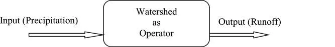
The watershed is a fundamental concept in hydrology and is the basis for understanding the hydrologic processes and for the planning and management of water resources. Storage and movement of water at a watershed scale is complicated due to the coupled processes which act over multiple spatial and temporal scales (Yu and Duffy 2018). Hydrologic processes within a watershed are extremely complex and are difficult to understand completely. However in an absence of perfect knowledge, these processes may be studied by means of the systems concept (Chow et al. 1998). Considering the watershed as a hydrologic system that can be defined as a structure or volume in space, surrounded by a boundary, that accepts water and other inputs, operates on them internally, and produces them as output. Here precipitation is the input, distributed in space over the watershed area; stream flow in the form of runoff concentrated at the outlet of the watershed is the output. Evaporation, transpiration and sub-surface flow could also be considered as outputs, but these are small compared to runoff or the stream flow during a storm. The structure of the system consists of the drainage lines over the watershed land surface or flow paths through the soil below the land surface and includes the tributary streams which merge to form stream flow at the watershed outlet. The schematic representation of systems operation is shown in Fig. 2. That means the watershed receives precipitation as input, operates upon it through the processes of interception, infiltration, percolation, overland flow, and channel flow, etc., and depending upon the soil, slope, and land-use/land-cover, antecedent moisture and other watershed characteristics generate output in the form of runoff as stream flow going out of the watershed through its outlet.
Fig. 2. Watershed as a hydrologic system.
Global vs. Watershed Hydrologic System
Water is being continuously moved between the atmosphere, the earth land surface and the oceans. This is known as the global hydrological cycle or global hydrologic system. This system is a closed system as there is no input or output, i.e., no water comes into or leaves the planet. On the other hand the watershed hydrologic system is an open system as it has a range of inputs and outputs as well as storages, transfers and flows. Inputs include precipitation including rain, snow, sleet and hail, groundwater flow from adjoining watersheds, and solar energy for evaporation. Outputs move water out of the watershed and include evapora...
Table of contents
Cover
Title Page
Copyright Page
Preface
Table of Contents
1. Watershed Hydrology and Management
2. Runoff and Rainwater Harvesting
3. Basics of Soil Erosion
4. Measurement of Soil Erosion by Water
5. Measures to Control Soil Erosion
6. Gully Erosion and its Control
7. Soil Erosion by Water-Model Concepts and Application
8. SWAT Model and its Application
9. Watershed Management in the 21st Century
10. Bio-industrial Watershed Management
11. Land Evaluation: A General Perspective
Index
Frequently asked questions
Yes, you can cancel anytime from the Subscription tab in your account settings on the Perlego website. Your subscription will stay active until the end of your current billing period. Learn how to cancel your subscription
No, books cannot be downloaded as external files, such as PDFs, for use outside of Perlego. However, you can download books within the Perlego app for offline reading on mobile or tablet. Learn how to download books offline
Perlego offers two plans: Essential and Complete
Essential is ideal for learners and professionals who enjoy exploring a wide range of subjects. Access the Essential Library with 800,000+ trusted titles and best-sellers across business, personal growth, and the humanities. Includes unlimited reading time and Standard Read Aloud voice.
Complete: Perfect for advanced learners and researchers needing full, unrestricted access. Unlock 1.4M+ books across hundreds of subjects, including academic and specialized titles. The Complete Plan also includes advanced features like Premium Read Aloud and Research Assistant.
Both plans are available with monthly, semester, or annual billing cycles.
We are an online textbook subscription service, where you can get access to an entire online library for less than the price of a single book per month. With over 1 million books across 990+ topics, we’ve got you covered! Learn about our mission
Look out for the read-aloud symbol on your next book to see if you can listen to it. The read-aloud tool reads text aloud for you, highlighting the text as it is being read. You can pause it, speed it up and slow it down. Learn more about Read Aloud
Yes! You can use the Perlego app on both iOS and Android devices to read anytime, anywhere — even offline. Perfect for commutes or when you’re on the go. Please note we cannot support devices running on iOS 13 and Android 7 or earlier. Learn more about using the app
Yes, you can access Watershed Hydrology, Management and Modeling by Abrar Yousuf, Manmohanjit Singh, Abrar Yousuf,Manmohanjit Singh in PDF and/or ePUB format, as well as other popular books in Sciences biologiques & Biologie. We have over one million books available in our catalogue for you to explore.