- 528 pages
- English
- ePUB (mobile friendly)
- Available on iOS & Android
eBook - ePub
The Indian Ocean Tsunami
About this book
The Indian Ocean tsunami of December 2004 is considered to have been one of the worst natural disasters in history, affecting twelve countries, from Indonesia to Somalia. 175,000 people are believed to have lost their lives, almost 50,000 were registered as missing and 1.7 million people were displaced. As well as this horrendous toll on human life
Tools to learn more effectively

Saving Books

Keyword Search

Annotating Text

Listen to it instead
Information
Part 1
Geostructural environment of tsunami genesis
CHAPTER 1
A Historical Account of the Earthquakes and Tsunamis in the Indian Ocean
B.K. Rastogi
National Geophysical Research Institute, Hyderabad, India
1.1 INTRODUCTION
A catalog of tsunamis in the Indian Ocean during the period 326 BC to 2005 AD has been compiled. Possible source zones of large tsunamigenic earthquakes in the Indian Ocean have been identified. Repeat periods of strong earthquakes in these zones are also assessed.
Tsunamis are not as common in the Indian Ocean as in the Pacific. As compared to average eight tsunamis per year in the Pacific, Indian Ocean has no more than one in 3 years or so. Eighty percent of the tsunamis of the Indian Ocean originate in the Sunda arc covering Java and Sumatra. A catalog of tsunamis presented here includes about 70 tsunamis from Sunda arc and about 20 tsunamis from the rest of the Indian Ocean. The same belt extends northward to Andaman–Nicobar Islands where a few tsunamis have originated. Further north, Bangladesh– Myanmar coast has produced some well-documented tsunamis. Makran coast in the northwest is known to have generated at least one major tsunami. Karachi–Kutch coast region is a possible source zone. Other regions like Chagos Ridge can give rise to local tsunamis. Tsunamis are mostly caused by thrust-type subduction zone earthquakes which are sometimes associated with landslides. The seismic gap areas along the subduction zones are possible sites of future great earthquakes. Along the Sunda arc, great earthquakes of M8.5 or greater can be repeated every two centuries at a site but smaller tsunamigenic earthquakes can be repeated every few decades. Along Sunda arc volcanic eruptions have also given rise to large tsunamis. There appears to have been a hiatus in tsunami generation in this region, with a significant gap in events occurring from around 1909 through 1967 (Tsunami Laboratory, Novosibirsk, Russia). Tsunamis from the Java region are not described in detail as their effects are restricted to Indonesia.
1.2 TSUNAMIGENIC EARTHQUAKE SOURCE ZONES IN THE INDIAN OCEAN
Thrust-type earthquakes occurring along subduction zones that cause vertical movement of ocean floor tend to be tsunamigenic. During rupture of a subduction megathrust, for example along the Sumatra arc, the portion of southeast Asia that overlies the megathrust jumps westward (toward the trench) and upward by several meters. This raises the overlying ocean, so that there is briefly a “hill” of water overlying the rupture. The flow of water downward from this hill triggers a series of broad ocean waves that are capable of traversing the entire Bay of Bengal. When the waves reach shallow water they slow down and increase greatly in height – from a few meters to some tens of meters – and thus are capable of inundating low-lying coastal areas. The maximum tsunami run-up is generally twice the vertical movement of the ocean floor and its power depends on the rupture area. Landslide of the ocean floor associated with earthquakes adds to the power of tsunami.
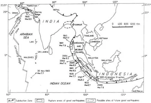
Figure 1.1. Rupture areas of great earthquakes of Mw 7.7 or greater and inferred seismic gap areas that could be sites of future tsunamigenic great earthquakes in the Indian Ocean.
In the near future, earthquakes along southern Sumatra, Makran coast, Indus Delta, Kutch– Saurashtra coast, Bangladesh and southern Myanmar might cause tsunamis which can affect India (Figures 1.1–1.3).
The seismic gap areas along subduction zones like Andaman–Sumatra and Makran can be assessed as possible future source zones of tsunami-generating earthquakes in the Indian Ocean and the repeat periods of great earthquakes can be assessed from past seismicity. Along the Andaman–Sumatra trench, the convergence rate is 40–50 mm/year yielding return periods of 150–200 years for great to giant earthquakes of M8.5 or greater. Major tsunamigenic earthquakes of M < 8.0 have been repeated more frequently at intervals of over a few decades. Occurrence of M8.5 earthquake of 2005 at the rupture zone of M8.5 earthquake of 1861 matches with the estimated recurrence rate. However, some great earthquakes have occurred more frequently: rupture zone of 1833 M8.7 earthquake overlapped 1797 M8.2 rupture zone (i.e. within 36 years). Smaller but tsunamigenic earthquakes, of M7.5–8.0 have been repeated more frequently at intervals of over a few decades like 1907 (Ms7.6) and 1935 (Mw 7.7) major earthquakes that occurred near the 1861 (Mw 8.5) source zone.
The Sumatran subduction zone is one of the most active plate tectonic margins in the world, accommodating over 50 mm/year of oblique northward convergence between the south Asian and India–Australian plates, which arcs 5500 km from Myanmar past Sumatra and Java toward Australia. The plates meet 5 km beneath the sea at the Sumatran trench, on the floor of the Indian Ocean. The trench runs roughly parallel to the western coast of Sumatra, about 200 km offshore. At the trench, the Indian–Australian plate gets subducted; that is, it is plunging into the earth’s interior and being overridden by southeast Asia. The contact between the two plates is a “megathrust”. The two plates do not glide smoothly past each other along the megathrust but move in “stick-slip” fashion. This means that the megathrust remains locked for centuries, and then slips suddenly a few meters, generating a large earthquake. Some coastal areas east of the megathrust sink by a meter or so, leading to permanent swamping of previously dry, habitableground. Islands above the megathrust rise 1–3 m, sothat shallow coral reefs emerge from the sea.
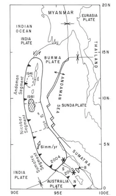
Figure 1.2. Source zones of 2004 and 2005 earthquakes in Sumatra–Andaman zone.
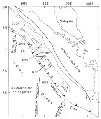
Figure 1.3. Rupture areas of past great earthquakes along Sumatra. The southern Sumatra zone is apossible site for future great earthquake.
Sunda arc extends further north to the Andaman–Nicobar group of islands which is also seismically active zone and generates frequent large earthquakes. Large earthquakes occurred in 1847 (Mw > 7.5), 1868, 1881 (Mw 7.9) and 1941 (M7.7). Future locales are seismic gap areas that have remained unruptured in the past few decades. The 2004 Sumatra earthquake of M9.3 occurred in one such gap. The 28 March 2005 earthquake of M8.7 has occurred in a gap area south of the 2004 rupture identified by Kerry Sieh of Caltech. The 2005 earthquake was probably triggered by the 2004 Sumatra earthquake. Further south along Sumatra trench large and great earthquakes can be expected within a few decades. Mw 7.8 earthquake of 2000 has occurred along the southernmost tip of Sumatra.
Northern Sumatra and Andaman regions are assessed to be probably free from great earthquakes for a few decades due to occurrence of 2004 Mw 9.3 and 2005 Mw 8.7 earthquakes. Southern Sumatra has potential for a great earthquake. However, the effect of tsunami due to this in India and Sri Lanka may be a limited one as the path of tsunami will be oblique to the rupture zone.
The Makran subduction zone of southern Pakistan and Iran is seismically less active, but has produced great earthquakes. The 28 November 1945 (Mw 8.0) earthquake generated the last major tsunami in the Arabian Sea. More than 4000 people were killed on the Makran coast by both the earthquake and the tsunami. The tsunami caused damage in Mumbai with 2-m run-up and affected Karwar (Karnataka). This earthquake occurred in the eastern part of the Makran zone, two sides of which remain potential zones for great earthquakes. Indus Delta and probably the coasts of Kutch and Saurashtra are also potential zones for great earthquakes and tsunami. Tsunami was generated by an earthquake in 1762 in Myanmar and possibly in 1874 by an earthquake near Bangladesh. Some earthquakes in future also in these regions can possibly generate tsunamis.
Normal fault-type earthquakes can also generate moderate tsunami. Strike-slip earthquakes that cause horizontal movement of ocean floor are not tsunamigenic but oblique-slip/dip-slip component in them can generate weak tsunamis. Spreading zones like Carlsberg ridge, Ninety-East ridge, etc. are sites of such earthquakes. The Chagos ridge east of Carlsberg ridge had given rise to a local tsunami due to thrust component of motion for a major earthquake of Mw 7.7 earthquake of 30 November 1983 near Diego Garcia.
1.3 EARTHQUAKES AND TSUNAMIS FROM SUNDA ARC REGION
Newcomb and McCann (1987) compiled historic records of earthquakes and tsunamis from Sunda arc region. An updated list is given in Table 1.1. The Sumatra part of the Sunda arc had been much more active than Java part. Detailed description of some of the significant earthquakes and the tsunamis caused by them are given below.
1.3.1 Earthquakes in Sumatra
See Table
Table 1.1. List of tsunamis in Sumatra-Java region.
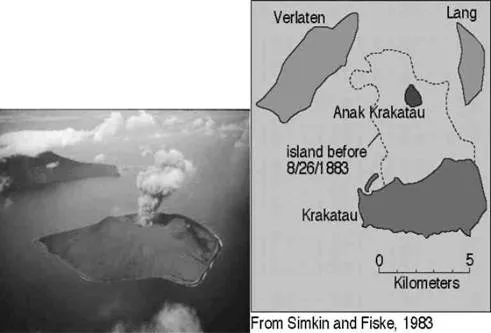
Figure 1.4. Krakatau volcanic eruption, 1883 (Source: Simkin & Fiske, 1983).
Historic records show that the strongest tsunami was associated with the volcanic eruption of Krakatau in Indonesia on 27 August 1883. The 35 m-high tsunami took a toll of 36,000 lives in western Java and southern Sumatra. The island volcano of Krakatau exploded with devastating fury, blowing its underground magma chamber partly empty so much so that much overlying land and seabed collapsed into it. Figure 1.4 shows the parts of the island that fell into the sea. A series of large tsunami waves was generated from the explosion, some reaching a height of over 35 m above sea level. Tsunami waves were observed throughout the Indian Ocean, the Pacific Ocean, the American west coast, South America and even as far away as the English Channel. On the facing coasts of Java and Sumatra the sea flood went many kilometers inland and caused such vast loss of life that one area was never resettled and is now the Ujung Kulon nature reserve. At its peak, the island of Rakata, which the volcano of Krakatau had formed, had reached a height of 790 m above sea level.
Subsequent local tsunamis in the Sunda Strait were generated by the 1927 and 1928 eruptions of the new volcano ofAnak Krakatau (Child of Krakatau) that formed in the area. Although large tsunamis were generated from these recent events, the heights of the waves attenuated rapidly away from the source region, because their periods and wavelengths were very short. There was no report of damage from these more recent tsunamis in the Sunda Strait (George, 2003).
1.3.2 Krakatau explosive eruption (1883)
According to ancient Japanese scriptures, the first known supercolossal eruption of Krakatau occurred in the year 416 AD – some gave the date as 535 AD. The energy of this eruption is estimated to have been about 400 Mt of TNT, or the equivalent of 20,000 Hiroshima bombs. This violent early eruption destroyed the volcano, which collapsed and created a 7-km-wide submarine caldera. The remnants of this earlier violent volcanic explosion were the three islands of Krakatau, Verlaten and Lang (Rakata, Panjang and Sertung). Undoubtedly the 416 AD eruption/ explosion/collapse must have generated a series of catastrophic tsunamis, damage from which must have been much greater than those generated in 1883. However, there are no records documenting the size of these early tsunamis or the destruction they caused. Subsequent to the 416 AD eruption and prior to 1883, three volcanic cones of Krakatau and at least one older caldera had combined again to form the island of Rakata. The volcanic cones on the island were aligned in a north–south direction. The northernmost was called Poeboewetan and the southernmost was called Rakata. Overall approximate dimensions of the island were 5 km × 9 km (George, 2003).
See Table
The 2004 Sumatra–Andaman earthquake of M9.3 generated 30-m-high tsunami when upward slip of the ocean floor was up to 15 m along a 1300-km long and 160–240-km-wide rupture. It was the deadliest tsunami killing about 300,000 people in 13 countries situated all around the Indian Ocean. The tsunami power was enhanced by large landslides over the rupture zone of 2004 earthquake. The earthquake had created large thrust ridges, about 1500m high, which collapsed in places to produce large landslides, several kilometers across. The force of displaced water was such that blocks of rocks, massing millions of tons apiece, were dragged as much as 10 km. An oceanic trench several kilometers wide was also formed.
The M8.7 great Sumatra earthquake of 28 March 2005 with an upward movement of 2m of seafloor in an area of 400 km × 100 km generated a locally damaging 4-m-high tsunami that struck nearby islands and coastal Sumatra and was recorded by tidal stations in the Indian Ocean (asc.India.org). The earthquake and tsunami killed 665 people. The tsunami struck Nias Island with wave heights of 4–5 m. A 3–4 m wave struck the islands of Banyak and Simeulue, and the Singkil District of Sumatra. According to the Pacific Tsunami Warning Center (PTWC), tide gauges in the Indian Ocean recorded minor wave activity in the Australian Cocos Island (10–22 cm), the Maldives (10 cm) and Sri Lanka (25–30 cm).
1.4 TSUNAMIS THAT AFFECTED THE INDIAN REGION AND VICINITY
Though rare, tsunamis have hit India earlier. The tsunamis in the Indian region and vicinity are listed in Table 1.2. The oldest record of tsunami is available from November 326 BC earthquake near the Indus Delta/Kutch region that set off massive sea waves in the Arabian Sea. Alex...
Table of contents
- Cover Page
- Half Title
- Title Page
- Copyright Page
- Cover Illustration
- In Remembrance
- A Note of Reflection and Dedication
- Dedication
- Table of Contents
- Figures
- Tables
- Foreword
- Prologue
- Preface
- Part 1: Geostructural environment of tsunami genesis
- Part 2: Modelling of Tsunami Generation and Propagation
- Part 3: Tsunami Detection and Monitoring Systems
- Part 4: Biophysical and Socio-Economic Dimensions of Tsunami Damage
- Part 5: Quo Vadis
- Author Index
- Subject Index
Frequently asked questions
Yes, you can cancel anytime from the Subscription tab in your account settings on the Perlego website. Your subscription will stay active until the end of your current billing period. Learn how to cancel your subscription
No, books cannot be downloaded as external files, such as PDFs, for use outside of Perlego. However, you can download books within the Perlego app for offline reading on mobile or tablet. Learn how to download books offline
Perlego offers two plans: Essential and Complete
- Essential is ideal for learners and professionals who enjoy exploring a wide range of subjects. Access the Essential Library with 800,000+ trusted titles and best-sellers across business, personal growth, and the humanities. Includes unlimited reading time and Standard Read Aloud voice.
- Complete: Perfect for advanced learners and researchers needing full, unrestricted access. Unlock 1.4M+ books across hundreds of subjects, including academic and specialized titles. The Complete Plan also includes advanced features like Premium Read Aloud and Research Assistant.
We are an online textbook subscription service, where you can get access to an entire online library for less than the price of a single book per month. With over 1 million books across 990+ topics, we’ve got you covered! Learn about our mission
Look out for the read-aloud symbol on your next book to see if you can listen to it. The read-aloud tool reads text aloud for you, highlighting the text as it is being read. You can pause it, speed it up and slow it down. Learn more about Read Aloud
Yes! You can use the Perlego app on both iOS and Android devices to read anytime, anywhere — even offline. Perfect for commutes or when you’re on the go.
Please note we cannot support devices running on iOS 13 and Android 7 or earlier. Learn more about using the app
Please note we cannot support devices running on iOS 13 and Android 7 or earlier. Learn more about using the app
Yes, you can access The Indian Ocean Tsunami by Tad S. Murty,U. Aswathanarayana,Niru Nirupama in PDF and/or ePUB format, as well as other popular books in Physical Sciences & Geology & Earth Sciences. We have over one million books available in our catalogue for you to explore.