eBook - ePub
Travel, Communication and Geography in Late Antiquity
Sacred and Profane
- 184 pages
- English
- ePUB (mobile friendly)
- Available on iOS & Android
eBook - ePub
About this book
Travel, Communication and Geography in Late Antiquity brings together a set of papers that consider anew issues of travel, communication and landscape in Late Antiquity. This period witnessed an increase in long-distance travel and the construction of large new inter-provincial communications networks. The Christian Church's expansion is but one example of both phenomena. The contributions here present readers with new research on the explosion in travel and large-scale communication, and the effect on this of different geographical possibilities and limitations. The papers deal with a variety of travel experiences (religious pilgrimages; travel for work and educational purposes; journeys of the soul) and writings about travel; they look at various kinds of communication (ecclesiastical communication; communication for commerce; and the communication of religious identity); and they examine both physical and psychological aspects of geography, travel and communication.
Trusted by 375,005 students
Access to over 1.5 million titles for a fair monthly price.
Study more efficiently using our study tools.
Information
PART ONE
ASPECTS OF SECULAR TRAVEL IN LATE ANTIQUITY
Part One
Aspects of Secular Travel in Late Antiquity
Introduction
The four papers grouped in this section call attention to the many factors that shaped non-religious travel in the late antique world. Elton reminds us of the basic constraints that geography placed on state and military travel in this period. Watts discusses the way educational centers rose and fell during Late Antiquity and presents travel in terms of the relation of centers to peripheries, issues of interest in current scholarly discussion of the late antique world and its transformation. Cam Grey discusses evidence for the movement of rural laborers from one landlord’s estate to another. Analysis of this kind of travel contributes to the ongoing reassessment of the juridical and economic status of the colonate in the Late Empire and the disparities between legal representations of the group and their actual condition ‘on the ground’. Some of Grey’s rural laborers traveled from estate to estate on roads. These roads are the subject of the last paper in this section. In it Ray Laurence discusses the multiple functions of milestones along the late antique road system. They not only measured distance for the traveler but also communicated a variety of state-sponsored messages to those who moved along the road system. Laurence thus call attention to an underutilized form of evidence drawn from late antique material culture that can help us to understand change in the political world. Laurence also emphasizes the communicative aspects of the milestone system and thus points to the second section of papers in this collection.
Chapter 1
Cilicia, Geography, and the Late Roman Empire
This paper shows how geography affected warfare in a predictable way in Cilicia, today the part of Turkey north of Cyprus. In the period covered here, the third to seventh centuries AD, two types of campaigns can be distinguished, those fought between two field armies in the plains and those between a field army and small forces defending positions in the mountains. These types of campaigns, rather than the nature of the opponents, i.e., Romans against Sassanids or Romans against Romans, determined the location of engagements. A subcategory of operations not considered is Roman actions against raiders, such as the Goths, Isaurians or Huns who plundered the region occasionally.1
Cilicia was surrounded by the Taurus and Amanus Mountains and access was confined to a few passes.2 Interestingly, mountain passes were not good military barriers since the constricted space made deployment and maneuver difficult. Thus fighting in the pass itself was usually only carried out by heavily outnumbered forces who also ran the risk of being trapped by outflanking forces.3 The classic example of this is the outflanking of the Spartan Leonidas at Thermopylae in 480 BC, but it is worth noting that Gauls broke through here against the Phocians in 289 BC, and that Cato turned Antiochus III’s flank at the same pass in 191 BC.4 Even knowledge that a pass could be outflanked did not stop it happening. Other routes existed across the Taurus Mountains besides those discussed here, but these were tracks unsuitable for the passage of large armies, though often passable for raiders and flanking forces.
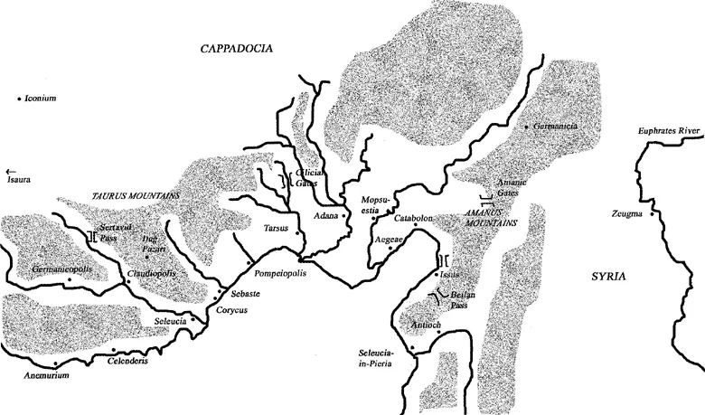
In the first type of campaign, those fought between two field armies in the plains, the objective was to force the opponent’s field army into an untenable position. These campaigns occurred between rival imperial candidates in Roman civil wars and in campaigns between Rome and Sassanid Persia. The campaigns were confined to major roads, usually the great military highway which ran through Cilicia and linked Constantinople to Antioch. The armies which fought these campaigns were large, often more than 30,000 strong, and were accompanied by enormous baggage trains with thousands of wagons and pack animals. Julian’s army in Persia in 363 was four miles long on the march. The wheeled transport accompanying such armies, whether Roman or Sassanid, could rarely stray from major roads. Similarly, supplying these forces when they were on major roads was much easier.5 In the second type of campaign, smaller armies attempted to besiege the enemy in their mountainous bases. To be besieged was never the primary strategy of the defenders, but was often the result of failure in an earlier battle fought along major roads in the lowlands. These campaigns only took place in Isauria, the mountainous western part of the region. They did not occur in the eastern lowlands of Cilicia or in the poorly urbanized eastern Taurus or Amanus. These principles together with an understanding of Cilician geography can be used to attempt to fill some gaps in the historical record.
The Sassanid Persian invasion of 260 shows some constraints that geography placed on the movement of armies, even without the presence of an opposing force. After a battle somewhere between Edessa and Carrhae, the Roman Emperor Valerian was captured and Sassanid armies drove west.6 Much of our knowledge of this campaign comes from the Naqsh-I Rustam inscription erected by the Sassanid king Sapor, but the inscription says nothing about the route taken between the capture of Valerian and the Sassanid arrival in Cilicia.7 Large armies could take two routes between Syria and Cilicia, both of which involved crossing the Amanus Mountains. The usual route was the military road, also used by pilgrims to the Holy Land.8 One was in the south at the Syrian Gates, the modern Beilan Pass (750m).9 The other, far less traveled, was in the central Amanus, crossing at the Amanic Gates, near the modern Hasanbeyli Pass (1150m), though several smaller passes existed in the vicinity. Since Roman sources (though, interestingly, not Sapor’s inscription) record the capture of Antioch, the Sassanids can be assumed to have entered Cilicia via the Beilan Pass.10
Once across the mountains, Persian forces proceeded to sack the lowlands thoroughly, ravaging sixteen of the seventeen bishoprics in the province of Cilicia. But in the uplands of Isauria, Sassanid forces reached only the coastal cities of Celenderis, Anemurium, Selinus, Myus, Antioch-ad-Cragum, Domitiopolis and Seleucia.11 The difficulties of access along the coastal road would suggest that only a part of the Sassanid army was involved in this part of the campaign. The major cities of the Calycadnus Valley, Claudiopolis and Germanicopolis, were not directly affected by the Persians, possibly because it was easier for the Romans to defend the mountains.
Sapor’s troops then left Cilicia, advancing across the Taurus to Cappadocia. There were two routes across the Taurus, though the road north of Tarsus, the Cilician Gates (Gülek Bogazi), was the only practical route for a large army.12 The second route across the Taurus followed the Calycadnus Valley from Seleucia to Claudiopolis, then ran on to Iconium. The ancient route is uncertain. It may have followed the modern road, leading to the Sertavul Pass, or it may have run a little farther east, via Dagpazari. This pass was not suitable for wagons and saw little non-local use in antiquity.13 Part of the answer may be the relative heights of the passes. The Cilician Gates were only 1050m, the Sertavul Pass 1610m. Moreover, crossing the Cilician Gates involved spending less time in the mountains, whereas the Calycadnus Valley involved long and difficult mountainous marches. Since Claudiopolis was not sacked, Sapor can be assumed to have taken the Cilician Gates on his march to Cappadocia.
For most of this campaign, the Sassanids faced little opposition. But when a Roman army arrived, then the pattern of operations changed. One of Valerian’s generals, Ballista, campaigned along the southern coast of Cilicia. He relieved the besieged Pompeiopolis (possibly not listed in Sapor’s inscription and perhaps never sacked), and then won a victory at Corycus and Sebaste in which 3000 Persians were killed.14 It is possible that Ballista arrived in the region by sea. Roman soldiers were used to sailing into Cilicia, though usually to Aegeae, where many troops were disembarked for eastern campaigns (though Seleucia in Pieria in Syria was also used). Aegeae’s importance is nicely shown by the tombstone of Vivius Batao, a soldier of Legio II Parthica who died at Aegeae in 215. He was buried at Catabolon, but not commemorated until his unit reached Apamea in Syria.15 The absence of a Roman field army to oppose Sapor allowed military operations to take place throughout the lowlands. However, with the exception of the attacks on the Isaurian coastal ci...
Table of contents
- Cover
- Half Title
- Title Page
- Copyright Page
- Table of Contents
- List of Figures
- List of Contributors
- Preface
- Editors’ Introduction
- Introduction: And Up and Down the People Go
- Part One: Aspects of Secular Travel in Late Antiquity
- Part Two: Elite Communication Networks
- Part Three: Reconsidering Late Antique Pilgrimage
- Index of Persons
- Index of Geographical Names
Frequently asked questions
Yes, you can cancel anytime from the Subscription tab in your account settings on the Perlego website. Your subscription will stay active until the end of your current billing period. Learn how to cancel your subscription
No, books cannot be downloaded as external files, such as PDFs, for use outside of Perlego. However, you can download books within the Perlego app for offline reading on mobile or tablet. Learn how to download books offline
Perlego offers two plans: Essential and Complete
- Essential is ideal for learners and professionals who enjoy exploring a wide range of subjects. Access the Essential Library with 800,000+ trusted titles and best-sellers across business, personal growth, and the humanities. Includes unlimited reading time and Standard Read Aloud voice.
- Complete: Perfect for advanced learners and researchers needing full, unrestricted access. Unlock 1.5M+ books across hundreds of subjects, including academic and specialized titles. The Complete Plan also includes advanced features like Premium Read Aloud and Research Assistant.
We are an online textbook subscription service, where you can get access to an entire online library for less than the price of a single book per month. With over 1.5 million books across 990+ topics, we’ve got you covered! Learn about our mission
Look out for the read-aloud symbol on your next book to see if you can listen to it. The read-aloud tool reads text aloud for you, highlighting the text as it is being read. You can pause it, speed it up and slow it down. Learn more about Read Aloud
Yes! You can use the Perlego app on both iOS and Android devices to read anytime, anywhere — even offline. Perfect for commutes or when you’re on the go.
Please note we cannot support devices running on iOS 13 and Android 7 or earlier. Learn more about using the app
Please note we cannot support devices running on iOS 13 and Android 7 or earlier. Learn more about using the app
Yes, you can access Travel, Communication and Geography in Late Antiquity by Linda Ellis,Frank L. Kidner in PDF and/or ePUB format, as well as other popular books in History & Ancient History. We have over 1.5 million books available in our catalogue for you to explore.