This book brings together in one place as much factual data as possible relating to the engineering geology of the Sydney Region, A huge amount of information resides in the files of various consulting and government organizations from the innumerable site investigations and construction projects in Sydney. This information brought together provides a data source that is the first point of reference for future investigations and construction projects.
With the above object in mind subject headings were established based on the stratigraphic sequence of the Sydney Basin. Invitations were extended to potential authors with expertise and experience in these subjects and after some two years, the papers in this volume were produced.
Engineering Geology of the Sydney Region is produced by a committee. As such it has the advantage of canvassing a broad range of opinion and experience. A data source has been produced for geotechnical engineers and engineering geologists working in or having a particular interest in the Sydney Region.
eBook - ePub
Engineering geology of the Sydney Region
Published on behalf of the Australian Geomechanics Society
- 407 pages
- English
- ePUB (mobile friendly)
- Available on iOS & Android
eBook - ePub
Engineering geology of the Sydney Region
Published on behalf of the Australian Geomechanics Society
About this book
Trusted by 375,005 students
Access to over 1.5 million titles for a fair monthly price.
Study more efficiently using our study tools.
Information
An overview of the geology of the Sydney Region
University of Sydney, Australia
ABSTRACT: The Sydney region consists dominantly of gently-deformed Triassic sandstones and shales, with minor occurrences of Irregularly distributed Cainozoic sediments. Igneous rooks consist of breccia necks and dolerite dykes, varying in age from Jurassic to Tertiary. The landscape consists of a central undulating plain flanked north, south and west by extensive plateaux. Jointing is well-developed and minor faulting and folding is common. The geological history of the area has produced a variable landscape which presents a variety of problems for the geotechnical engineer. These problems, discussed in detail in later papers in this volume, are briefly described in the text and accompanying illustrations.
1.1 INTRODUCTION
This paper is intended as a broad introduction to the geology of the Sydney region, with particular emphasis on those aspects of geology which may affect the work of geotechnical engineers and engineering geologists. A wide range of references is supplied which should lead the reader to more detailed data on the various topics which can only be treated in a general way in this paper.
Later papers in this volume expand the topics introduced here, particularly enlarging the relevant geotechnical aspects.
The area of prime interest of this publication is bounded roughly by Broken Bay in the north, the Nepean River in the west, Campbelltown and Royal National Park in the south (Figure 1.1). Occasional reference will be made to adjacent areas of relevance but no in-depth discussion will be made of areas such as the Wollongong–Stanwell Park coastal region, the Blue Mountains Plateau, or the Gosford–Newcastle coastal region.
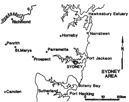
Figure 1.1 Sydney region
Problems of coastal erosion and harbour engineering have also been regarded as beyond the scope of this volume.
Readers should refer in particular to the Geological Series Sheet (Sydney) 9130 (Edition 1) 1983 published by the Geological Survey of New South Wales, Department of Mineral Resources, Sydney and to adjacent sheets Penrith, Gosford, St. Albans, Wollongong & Port Hacking, available only in dyeline, all at a scale of 1:100,000 on which much valuable information can be found. The Sydney Sheet will be referred to in the remainder of this paper as the Sydney 1: 100,000 sheet.
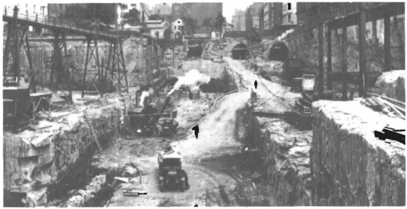
Figure 1.2 Excavations for Wynyard Station, 1927.
1.2 HISTORICAL REVIEW
Some of the earliest geological work in Australia was carried out in the Sydney district, but it is remarkable that no really detailed geological map of the city and its environs has yet been published.
Engineers, planners and others concerned with large structures are becoming increasingly aware of the necessity for detailed foundation data in the region. This volume reviews available geological information, both published and unpublished, which should serve as a basis for engineering projects, (Figure 1.2).
Legget (1973) has shown the value of delving into historical records to find out about changes which may have occurred on city sites, and Branagan and Moelle (1981) outline problems which might have been avoided at Newcastle had adequate records of mining been kept. There has been little research in this field in Sydney, although there are encouraging signs in the profession of an awakening interest. Henry (1939) and Aird (1961) provided some useful data on the water supply and sewerage systems, and the excellent history of the Department of Main Road (1976) contains much useful Information, as does Kennedy and Kennedy (1982).
There are still lessons to be learnt in the experiences of John Busby (1765–1857) who can be regarded as Australia’s first engineering geologist. Skilled in drainage and tunnelling work Busby suffered the frustrations of bureaucratic delays and unskilled workers during the eleven years (1826–1837) he toiled to plan and drive a tunnel from Hyde Park to Centennial Park to tap the water source there, (Figure 1.3). In providing wells for the citizens of Sydney on busy street corners, while the tunnel was in progress, Busby found his employer, the Government, would not indemnify him when a worthy gentleman’s carriage was upset at a well-site in George Street and he sued Busby! By 1830 Busby was supplying water from the tunnel, there being considerable seepage from the joints and fractures in the Hawkesbury Sandstone. Busby’s letter-books and reports (Mitchell Library) contain information on plans to deepen the upper Parramatta River and a variety of other topics.
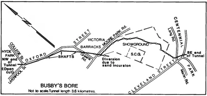
Figure 1.3 Busby’s Bore, Sydney’ first major tunnel Completed 1837.
Similarly the activities of Major George Barney (1792–1862), military engineer, responsible for the modifications which led to the building of Circular Quay can provide considerable information.
Some of the work of Thomas Mitchell (1792–1855) on roads, and David Lennox (1788–1873) on bridges is discussed in Department of Main Roads (op cit) and in Cumpston (1954) and Herman (1954), and that of John Whitton (1820–1898), the railway engineer in Department of Railways (1955), but there is still much to be learnt about the technical data recorded by these men and others such as Thomas Woore (1804–1878), (Branagan, 1982) in the mid-nineteenth Century.
In many instances the New South Wales parliamentary papers (both Assembly and Council) prove to be fruitful sources of information.
In the latter part of the 19th Century and through the early years of the 20th Century, members of the Geological Survey of New South Wales provided much of the advice sought by engineers. In particular C.S. Wilkinson (1834–1891), Edgeworth David (1858–1934), E.F. Pittman (1849–1932), E.C. Andrews (1870–1948), L.F. Harper (1872–1945) and M. Morrison (1872–1952) made many inspections and wrote reports, which though often sketchy by today’s standards, still provide considerable useful information.
1.3 PUBLISHED DATA
The first geological map at significant scale (1:150,000 approx.) was prepared by E.F. Pittman (1903), although earlier work by Curran (1899) is also useful. Pittman’s map was mostly concerned with igneous intrusions in the Sydney region and was accompanied by a tabular statement of the exposures recorded (M. Morrison, 1904). T.L. Willan’s map (1925), complete with overlay, is justly famous for the detail it includes on a scale 1:125,000 but apart from a fragmentary note, (Willan 1923), he left Australia without publishing a comprehensive statement of his work. Osborne (1948) summarised the state of geological knowledge of the area and gave a comprehensive list of references.
Lovering (1953) produced some useful work particularly covering the shale regions of the western suburbs. Although his published maps (Lovering, 1954) are only on a scale of 1:300,000 his original thesis (1953) and copies held by the Joint Coal Board (Geology Section) contain maps at a scale of 1:63,360 covering a wide area.
In 1957 the first edition of the Sydney 4 mile (1:253,440) scale geological map was published with accompanying notes by C.T. McElroy. Second and third editions of the map have been published (1961, 1965) on the scale of 1:250,000. The third edition of the notes (Bryan, McElroy and Rose, 1966) contains a very large list of references.
J.C. Standard (1964) carried out a broad-scale study of many aspects of the Hawkesbury Sandstone. Much of this information is published in Packham (1969).
The geology of the Windsor-Richmond area is available on a scale of 1:50 000. Other maps at this useful large scale should shortly be published.
Possibly one of the most useful maps is the soil survey carried out by Walker (1960). Twelve map sheets (scale 1:62 500) cover the County of Cumberland in considerable detail and there is generally a good correlation with the geology.
More recently, an excellent terrain evaluation has been published (Finlayson, 1982) which shows the close relation between rook types and soils which exists over much of the Sydney region.
Details of the surface and subsurface geology in the Botany Bay region are given in Griffin (1963) with a map at 1:23,7600, and basic geology of many parts of Sydney is discussed in Branagan and Packham (1970). Detailed mapping of the Dee Why — Palm Beach area has been carried out and some of the information can be found in Packham (1976), Rettallack (1976) and in Branagan (1984).
Two papers which contain important ideas are Burgess (1977) and McMahon et al (1975), the latter setting out what has become a widely accepted classification for rook in the Sydney district.
Of particular value also are the recent volumes by Herbert (1983a) and Knight et al (1983). The former work, dealing specifically with the geology of the published Sydney 1:100,000 geological map, contains important summaries by Chesnut and others on many aspects of engineering and environmental geology. Branagan (1969a) also summarises aspects of engineering geology in the region.
1.4 OTHER DATA
Although considerable information is unpublished in the formal sense, much of it is still available in the form of reports. While most companies do not make information freely available, many statutory bodies have open-file access and these ‘working documents’ often prove of more immediate practical value than formal publications, particularly because of the scale of drawings. In this category the Geological Survey produced many reports, particularly those by the Engineering Geology section, now alas defunct. Reports by Chesnut (1980, 1981, 1982), McDonald (1975), Van Heeswyck (1976, 1977), Neville (1976) can be mentioned and there is an extensive bibliography in Chesnut (1983). However this excellent bibliography, judged by the relative paucity of reference to reports by other statutory bodies, shows one of the deficiencies of organisation in the profession — the lack of coordination which still exists.
Reports by the Snowy Moun...
Table of contents
- Cover
- Half Title
- Title Page
- Table of Contents
- 1 Overview
- 2 Tertiary and Recent sediments
- 3 Wianamatta Group
- 4 Hawkesbury Sandstone
- 5 Narrabeen Group
- 6 Intrusives
- 7 Land reclamation and fills
- 8 Construction materials
- 9 Tunnelling
- List of authors
Frequently asked questions
Yes, you can cancel anytime from the Subscription tab in your account settings on the Perlego website. Your subscription will stay active until the end of your current billing period. Learn how to cancel your subscription
No, books cannot be downloaded as external files, such as PDFs, for use outside of Perlego. However, you can download books within the Perlego app for offline reading on mobile or tablet. Learn how to download books offline
Perlego offers two plans: Essential and Complete
- Essential is ideal for learners and professionals who enjoy exploring a wide range of subjects. Access the Essential Library with 800,000+ trusted titles and best-sellers across business, personal growth, and the humanities. Includes unlimited reading time and Standard Read Aloud voice.
- Complete: Perfect for advanced learners and researchers needing full, unrestricted access. Unlock 1.5M+ books across hundreds of subjects, including academic and specialized titles. The Complete Plan also includes advanced features like Premium Read Aloud and Research Assistant.
We are an online textbook subscription service, where you can get access to an entire online library for less than the price of a single book per month. With over 1.5 million books across 990+ topics, we’ve got you covered! Learn about our mission
Look out for the read-aloud symbol on your next book to see if you can listen to it. The read-aloud tool reads text aloud for you, highlighting the text as it is being read. You can pause it, speed it up and slow it down. Learn more about Read Aloud
Yes! You can use the Perlego app on both iOS and Android devices to read anytime, anywhere — even offline. Perfect for commutes or when you’re on the go.
Please note we cannot support devices running on iOS 13 and Android 7 or earlier. Learn more about using the app
Please note we cannot support devices running on iOS 13 and Android 7 or earlier. Learn more about using the app
Yes, you can access Engineering geology of the Sydney Region by P.J.N. Pells in PDF and/or ePUB format, as well as other popular books in Technology & Engineering & Geology & Earth Sciences. We have over 1.5 million books available in our catalogue for you to explore.