- 602 pages
- English
- ePUB (mobile friendly)
- Available on iOS & Android
eBook - ePub
Tracing Technique in Geohydrology
About this book
This translation of the original German textbook, Hydrogeologie, summarizes tracing techniques. Individual chapters have been contributed by relevant experts from geology, hydrology, chemistry and virology, and engineering and isotope specialists. Text contributions are complemented by numerous figures. A cd rom will assist in the evaluation and presentation of data from tracing tests.
Tools to learn more effectively

Saving Books

Keyword Search

Annotating Text

Listen to it instead
Information
CHAPTER 1
Introduction
1.1 EXORDIUM
Hydrological tracing techniques (German: Markierungstechnik, French: traçage) use tracers (German: Markierungsmittel, French: traceur) to follow flowing water. Surface waterways such as rivers, lakes, and ocean currents can be followed, as well as underground waterways. In this field, the most important applications are in groundwater. Thus, this subject is now covered in the series ‘Textbooks of Hydrogeology’ (‘Lehrbuch der Hydrogeologie’). Tracing techniques in surface water are covered here as well.
Tracing techniques address a plenitude of scientific disciplines: geology, hydrology, chemistry, physics, water management, civil engineering, biology, limnology, etc. Therefore, the relevant scientific literature covers many fields and is found in the publications of many different disciplines. A trademark journal for tracing techniques is the journal ‘Styrian Contributions in Hydrogeology’ (‘Steirische Beiträge zur Hydrogeologie’), titled ‘Contributions in Hydrogeology’ (‘Beiträge zur Hydrogeologie’) after 1994, published in Graz, Austria by the Hydrogeological Research Union (Vereinigung für hydrogeologische Forschungen). Other noteworthy publications, in which branches of tracing techniques are handled, are: MOSER & RAUERT (1980) ‘Isotope Methods in Hydrology’, Vol. 8 of this textbook series that covers tracing with isotopes, ZÖTL (1974) ‘Karsthydrogeology’ and BÖGLI (1980) ‘Karsthydrology and Physical Speleology.’ Several journals contains summaries of tracing techniques. However, the main focus of these summaries lies in different areas. In 1959, MAURIN and ZÖTL published an extensive representation of the possibilities for tracing in karst regions then. Each of the proceedings published from the International Symposium on Underground Water Tracing (SUWT) conferences from 1966 until 1986 contain references to the advances made in tracing techniques in the introductory chapters. A more detailed report on tracing techniques, which covered mostly groundwater, was written by DAVIS, CAMPBELL, BENTLEY and FLYNN and was published in 1985 by the American Water Well Association. The ‘Leitfaden für den Gebrauch künstlicher Tracer in der Hydrogeologie’ by PARRIAUX, LISZKAY, MÜLLER and DELLA VALLE (1988) covers only the common tracer properties. In conclusion, the numerous publications, books as well as proceedings, by the International Atomic Energy Agency (IAEA) dealing with isotopes in hydrology needs to be mentioned (comp. Sections 2.11 and 4.4).
Originally, tracing experiments were used to find underground waterways.
In antiquity, the God Mercury used his staff ‘Virgula divina seu mercurialis (trepidano)’ to open the gates to the underworld.
The library of Ninive has documents about a goddess with a magical rod. During the Middle Ages, the so-called science of the Rhabdomants (dowsers) developed around magical rods. In one BC, the Roman masterbuilder VITRUV taught a method for discovering underground waterways by laying facedown on the ground at sunrise in places where fog occurs.
PLINIUS continued the ideas of VITRUV and taught that underground waterways could be surmised at sites where small insects appear at the surface (TIMEUS 1926).
Underground connections between surface waters have been long supposed in many regions. In ancient Greece the traveling writer STRABO conjectured that the water that seeped underground near San Cozian (Slovenian Karst) fed the Timavo spring located 130 stadia away (PFEIFFER 1963).
PFEIFFER (1963) collected and published a series of further ancient and medieval documents that reported percolating rivers, their underground passage, and their supposed resurgence points. According to STRABO (Geographia, Book VI), there are even two writers, OVID (Book XV) and HERODOT, who wrote about the percolating river Lykos (= Lykus) near Kolossä in the Middle East and its probable resurgence point in the Menderes Valley.
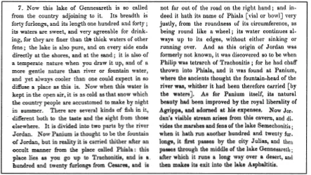
The first certain record of a tracing experiment that was actually carried out is over 1900 years old. The Jewish-Roman writer FLAVIUS JOSEPHUS wrote in circa 90 AD that the tetrarch PHILIPPUS from Trachonitis established the spring source of the Jordan around 10 AD by having fed chaff into Phialo, a circular pond. The chaff reemerged out of the cave spring Panium, which had been considered the source of the Jordan river (Fig. 1). The Phiale Lake is called Berekhat Ram now and lies near Banyas, the ancient Caesarea Philippi. Israeli geographers however call the Berekhat Ram a crater lake (Maar) and since chaff is not a very good tracer, the positive result of PHILIPPUS’S experiment is doubted (MAZOR 1976, ZÖTL 1989). RÖGNER however interprets the Berekhat Ram as a karst cave-in, which happened in the underlying Cretaceous chalk and carried through to the surface (1979).
The well-known percolation of the Upper Danube in Germany was described back in 1719 by the Prelate F.W. BREUNINGER, who wrote that the river noticeably lost water at the ‘Kalch-Steinen’ (= lime stones). He correctly surmised that the water that percolated between Immendingen and Möhringen reemerged at the Aach spring.
In the 17th century, just as PHILIPPUS had done in 10 AD, the Parson M J. MAYER conducted tracing experiments in the Swabian Alb, Southwestern Germany: Besides chaff and sawdust that were introduced into the doline, only a few days after a thunderstorm, the Blautopf Karst spring carried muddy water.
Thus, for quite a while now, people have wondered how they could follow underground waterways with positive proof. Chaff and sawdust were used as a first resource as well as thunderstorms in distant catchment areas of karst springs, as already mentioned. In the summer of 1924, such a thunderstorm was recorded in the Swabian Alb on the NW-border of the Blautopf catchment. After 24-30 hours, the Blautopf spring, 14 km away, carried muddy water (SIHLER 1929). These more or less suitable means have been used for quite a long time. For example, young eels with notched tails were introduced into the Reka percolation site near San Cozian, and they were then observed in the Timavo spring. Even flotation devices such as wooden balls, cork pieces and so on were used up to the 1950s in karst channels, although it had to be assumed that siphons would retain them.
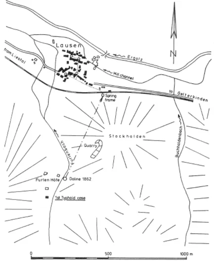
The first groundwater tracing experiment, known to the author, which was scientifically carried out and semi-quantitatively recorded, was carried out in the northern Swiss Jurassic platform. In the summer of 1872, almost one fifth of the population of Lausen in the Ergolz Valley, developed typhoid. The hygienist HÄGLER, from Basel, discovered that the first cases of typhoid had occurred unbeknownst in the early summer of the same year in an out of the way farm south of Lausen. The creek that flowed by the farm also carried away the sewage from the farm and percolated a short distance further downstream in a sink hole from the year 1862. The underground is composed of a thick layer of oolitic limestone (Hauptrogenstein), which borders to the west on a fault against Liassic marl. Back then, Lausen’s public water supply came from the oolitic (Hauptrogenstein) talus slope on the south flank of the Ergolz valley (Fig. 2). The mining director GLENK supplied the salt for the tracing test on 7 September 1872: 2045 Maas (ca. 3070 1) with a salt content of 18 hundredweights and 18 pounds (ca. 9 kg) from the nearby Saltworks Schweizerhalle. After one day the water supply showed a strong reaction to chloride with silver nitrate. Noticeable was also that only those villagers whose water came from the village water supply developed typhoid. In those homes, which had their own dug wells, no one developed typhoid. After the salt tracer test, a mixture of 50 hundredweights of flour was also poured into the sink hole. However, starch could not be detected in the water supply (HÄGLER 1873).
The best known river percolation in Middle Europe is the Upper Danube in southwestern Germany. The Danube is hardly on its way from its two spring sources, according to the saying:
‘Brigach and Breg start the Danube on its way’(‘Brigach und Breg bringen die Donau zuweg’)
when after approx. 30 km the river loses its water in minimal precipitation times to the karstified ground. When industrialization began in the last century, water power was the main energy source. The already quoted BREUNINGER verified that the water losses at the swallow holes had a...
Table of contents
- Cover Page
- Halftitle Page
- Title Page
- Copyright Page
- Motto
- Contents
- Editor’s Preface
- Author’s Preface
- 1 INTRODUCTION—W. Käss
- 2 TRACERS
- 3 PREPARATION AND REALISATION OF TRACING TESTS—W. Käss
- 4 EVALUATION AND INTERPRETATION OF TRACING TESTS—H.D. Schulz
- 5 PRACTICAL EXAMPLES OF APPLICATIONS AND INTERPRETATIONS
- References
- Conversion Tables
- Index of Localities
- Subject Index
- Color Plates
Frequently asked questions
Yes, you can cancel anytime from the Subscription tab in your account settings on the Perlego website. Your subscription will stay active until the end of your current billing period. Learn how to cancel your subscription
No, books cannot be downloaded as external files, such as PDFs, for use outside of Perlego. However, you can download books within the Perlego app for offline reading on mobile or tablet. Learn how to download books offline
Perlego offers two plans: Essential and Complete
- Essential is ideal for learners and professionals who enjoy exploring a wide range of subjects. Access the Essential Library with 800,000+ trusted titles and best-sellers across business, personal growth, and the humanities. Includes unlimited reading time and Standard Read Aloud voice.
- Complete: Perfect for advanced learners and researchers needing full, unrestricted access. Unlock 1.4M+ books across hundreds of subjects, including academic and specialized titles. The Complete Plan also includes advanced features like Premium Read Aloud and Research Assistant.
We are an online textbook subscription service, where you can get access to an entire online library for less than the price of a single book per month. With over 1 million books across 990+ topics, we’ve got you covered! Learn about our mission
Look out for the read-aloud symbol on your next book to see if you can listen to it. The read-aloud tool reads text aloud for you, highlighting the text as it is being read. You can pause it, speed it up and slow it down. Learn more about Read Aloud
Yes! You can use the Perlego app on both iOS and Android devices to read anytime, anywhere — even offline. Perfect for commutes or when you’re on the go.
Please note we cannot support devices running on iOS 13 and Android 7 or earlier. Learn more about using the app
Please note we cannot support devices running on iOS 13 and Android 7 or earlier. Learn more about using the app
Yes, you can access Tracing Technique in Geohydrology by Werner Kass in PDF and/or ePUB format, as well as other popular books in Biological Sciences & Environmental Science. We have over one million books available in our catalogue for you to explore.