Maps are tools used to understand space, discover territories, communicate information, and explain the results of geographical analysis. This practical handbook is about thematic cartography. With more than 120 colorful amazing illustrations, numerous boxed texts, definitions, and helpful tools, this step-by-step introduction to cartography is both the art of understanding the world and a powerful tool for explaining it. Through many hands-on tests, the reader will learn how to produce an interesting and communicative map applied to any spatial theme.
Written by experienced scholars and experts in cartography, this book is an excellent resource for undergraduate students and non-cartographers interested in designing, understanding, and interpreting maps. It includes practical exercises explained in the form of a game and provides a concise, accessible, and current address of cartographic principles, allowing readers to go deeper into cartographic design. It can be read from beginning to end like an essay or just by dipping into it for information as needed.
Trusted by 375,005 students
Access to over 1.5 million titles for a fair monthly price.
After having told young children that the Eartha is round, that it is a ball rolling through space like the sun or the moon, can I then show them an image in the shape of a rectangular sheet of paper with colored images? […]Should I try to make these little ones understand that the sphere has been changed into a planisphere (flat world map) – in other words, if I correctly understand the two juxtaposed words, a flat sphere?
Introduction
Data mobilized in geography and cartography is referred to as geographical data. This data relates to space and/or to phenomena localized on the surface of the Earth. Any information with an address or any element enabling localization in space (e.g., the identification of a place or a landscape) can become a piece of geographical information. Several definitions are proposed. According to Michael Frank Goodchild (1997), geographic information is information about places on the Earth’s surface, knowledge about where something is, and knowledge about what is at a given location. In summary, it is information that relates to one or more places in the terrestrial space (Beguin and Pumain, 2014). The geographic space is determined by reference to coordinates, either longitude and latitude for conventional mapping or some others forms for distorted maps.
Geographical information makes it possible to orient in space (where is a given phenomenon to be found?) and to compare localizations (why here rather than elsewhere, why here more than elsewhere?). In geography, this characteristic is essential, because a single, isolated piece of numerical data has no real meaning. It takes on meaning in comparison with other localities.
• FOCUS: Data or Information?
The terms “data” and “information” refer to concepts that overlap and can appear as synonymous. Data can be stored (figures, written material, photographs, videos, etc.). Information is the result of the action of interpreting data. For instance, gross domestic product (GDP) data give us information on the wealth of a country. It is possible to store the data enabling information to be produced from a database, but not this information itself, which results from a process of construction and interpretation. It is nevertheless common to speak of geographical information when what is meant is geographical data. This handbook is no exception.
To give data a spatial dimension, there are two possible operations:
Geo-referencing consists in positioning or marking by hand an object on a reference basemap. This operation can be conducted with the computer mouse, identifying the place to be referenced by a click, or by entering the geographic coordinates of the object if these are available directly, using the keyboard. Adjusting an image involves positioning exactly an object (such as an aerial photograph), so as to superimpose it on the basemap. Geo-referencing can also be performed directly in the field using a GPS device.
Geocoding consists in attributing geographic coordinates (longitude, latitude) to an address. To do this, a database is required giving references for each section of road, along with tools to exploit the database. These geocoding systems, which were for a long time on offer on the market, are now available, free of charge. For the USA, the website https://www.census.gov makes it possible to geocode addresses across the national territory via an online application.
It is often said that there are two types of geographical information:
Reference information concerns general data that can be used in numerous areas of activity: administrative boundaries, road networks, countries across the world, etc. A lot of this information is freely available online.
Thematic information concerns particular themes. It can be produced by businesses, study bureaus, or specialists of one or other domain. This information is more specialized and generally come at a cost. Today, the open data movement is facilitating access.
• FOCUS: Open Data
Open data is a movement that started up in the USA in the 1990s. It expanded in the 2000s with the development of Internet. It consists in issuing data (geographical or other) with an open license guaranteeing free access and use of the data. Today, many countries and cities around the world have switched to Open Data, which greatly facilitates the work of cartographers.
Whether the geographical information you are to use concerns reference information or thematic information, it can be divided into three types:
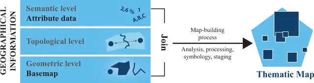
Geometric information, formed by points, lines, and polygons, describes the shape, the contour, and the localization of objects within a system of geographical or Cartesian coordinates. This is the basemap (Chapter 1).
Semantic information, made up of numerical values or text, relates to an object that is localized in space. It can be the name of a street, a plot number, or statistical information concerning the particular territorial unit (e.g., the number of inhabitants in Cherokee County (North Carolina). This type of data is often known as attribute data (Chapter 2).
Topological information is information deduced from the geometrical information. It is defined by spatial relationships between objects: proximity, distance, contiguousness, inclusion, etc. It can generate specific cartographic representations such as discontinuities, multi-scalar typologies, or smoothing.
Any thematic map will be the result of a combination of a basemap (geometrical information) and one or several types of data (semantic information).
Figure P1.I1 From geographical information to the thematic map.
Geographical information is the cartographer’s raw material. Making a map means converting geographical information into an image. Which basemap shoul...
Table of contents
Cover
Half Title
Title Page
Copyright Page
Table of Contents
Foreword
Authors
General Introduction
Part 1 Geographical Information
Part 2 Cartographical Language
Part 3 Beyond the Visual Variables
General Conclusion
Annexes
Bibliography
Index
Frequently asked questions
Yes, you can cancel anytime from the Subscription tab in your account settings on the Perlego website. Your subscription will stay active until the end of your current billing period. Learn how to cancel your subscription
No, books cannot be downloaded as external files, such as PDFs, for use outside of Perlego. However, you can download books within the Perlego app for offline reading on mobile or tablet. Learn how to download books offline
Perlego offers two plans: Essential and Complete
Essential is ideal for learners and professionals who enjoy exploring a wide range of subjects. Access the Essential Library with 800,000+ trusted titles and best-sellers across business, personal growth, and the humanities. Includes unlimited reading time and Standard Read Aloud voice.
Complete: Perfect for advanced learners and researchers needing full, unrestricted access. Unlock 1.5M+ books across hundreds of subjects, including academic and specialized titles. The Complete Plan also includes advanced features like Premium Read Aloud and Research Assistant.
Both plans are available with monthly, semester, or annual billing cycles.
We are an online textbook subscription service, where you can get access to an entire online library for less than the price of a single book per month. With over 1.5 million books across 990+ topics, we’ve got you covered! Learn about our mission
Look out for the read-aloud symbol on your next book to see if you can listen to it. The read-aloud tool reads text aloud for you, highlighting the text as it is being read. You can pause it, speed it up and slow it down. Learn more about Read Aloud
Yes! You can use the Perlego app on both iOS and Android devices to read anytime, anywhere — even offline. Perfect for commutes or when you’re on the go. Please note we cannot support devices running on iOS 13 and Android 7 or earlier. Learn more about using the app
Yes, you can access Practical Handbook of Thematic Cartography by Nicolas Lambert,Christine Zanin in PDF and/or ePUB format, as well as other popular books in Physical Sciences & Graphic Design. We have over 1.5 million books available in our catalogue for you to explore.