Satellite remote sensing, in particular by radar altimetry, is a crucial technique for observations of the ocean surface and of many aspects of land surfaces, and of paramount importance for climate and environmental studies. This book provides a state-of-the-art overview of the satellite altimetry techniques and related missions, and reviews the most-up-to date applications to ocean dynamics and sea level. It also discusses related space-based observations of the ocean surface and of the marine geoid, as well as applications of satellite altimetry to the cryosphere and land surface waters; operational oceanography and its applications to navigation, fishing and defense.
eBook - ePub
Satellite Altimetry Over Oceans and Land Surfaces
- 644 pages
- English
- ePUB (mobile friendly)
- Available on iOS & Android
eBook - ePub
Satellite Altimetry Over Oceans and Land Surfaces
About this book
Trusted by 375,005 students
Access to over 1.5 million titles for a fair monthly price.
Study more efficiently using our study tools.
Information
Subtopic
Geology & Earth Sciences1 Satellite Radar Altimetry
Principle, Accuracy, and Precision
Philippe Escudier, Alexandre Couhert, Flavien Mercier, Alain Mallet, Pierre Thibaut, Ngan Tran, Laïba Amarouche, Bruno Picard, Loren Carrere, Gérald Dibarboure, Michaël Ablain, Jacques Richard, Nathalie Steunou, Pierre Dubois, Marie-Hélène Rio, and Joël Dorandeu
1.1 INTRODUCTION
Radar altimetry was, very early in the development of space technology, identified as a key technique to provide essential information on solid Earth and ocean dynamics (see Williamstown report, Kaula 1969). This results from the fact that several important geophysical phenomena impacting the sea surface topography can be monitored using this measurement (see Chapters 4 to 11):
- Earth gravity. The geoid (equipotential surface of the Earth gravity field) is the largest signal in amplitude of topography undulations with respect to an ellipsoid (hundreds of meters). It includes large-scale signals related to Earth interior heterogeneity and short-scale signals related to bathymetry.
- Ocean dynamics. The ocean is a turbulent fluid the dynamics of which include multiple time and space scales (see Figure 1.1). Altimetry provides integral information on an ocean’s physical state (current speed, temperature, and salinity) from surface to the bottom that is key to monitoring these dynamics.
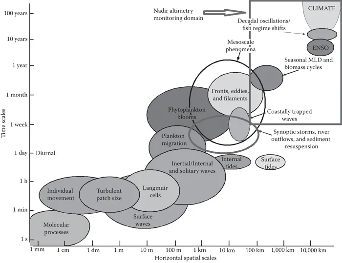
FIGURE 1.1 Typical spatial and timescales of ocean variability (Tommy 2003) and, superimposed in the rectangular shape located in the right upper corner, nadir altimetry monitoring domain.
Moreover, space altimetry techniques have proved to be efficient for non-ocean surfaces in monitoring such features as rivers, lakes, ice, snow, and so on.
In this chapter, we provide:
- An overall description of the measurement principles (Section 1.1.2)
- A detailed description of the measurement built up (Sections 1.2–1.6)
- A historical perspective of satellite radar altimetry (Section 1.1.1)
- An overall view of the performance requirements (Section 1.1.3)
- A detailed description of error budgets and sampling performance is given in Sections 1.7 and 1.8.
1.1.1 Satellite Altimetry Measurement Principle
Satellite altimetry calculation results from the combination of two measurements. The first one is the estimation of the satellite altitude with respect to an Earth reference (H), while the second is the measurement of the distance between the satellite and the targeted surface (D). By subtracting this distance to the satellite altitude, one obtains the required elevation of the targeted surface with respect to the reference (Sea Surface Height (SSH)):
SSH = H – D(1.1)
Figure 1.2 shows that satellite radar altimetry is a composite measurement resulting from the combination of data provided by multiple sensors combined with modeling and external data.
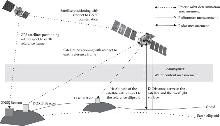
FIGURE 1.2 Satellite radar altimetry measurement principle: The main sensor used to compute the distance between the satellite and the targeted surface is a radar; however, to obtain the appropriate measurement accuracy, one needs a radiometer to measure the quantity of water that impacts the atmospheric propagation of the radar signal. To compute the altitude of the satellite with respect to an in situ network that constitutes the Earth reference, sensors on board the satellite are used in combination with modeling of satellite trajectory to perform the Precise Orbit Determination (POD) of the spacecraft (see Section 1.4).
The height measurement that is provided is an average of all elementary elevations over a zone the size and area of which depends upon the radar and antenna characteristics and the characteristics of the overflight surface (see Section 1.2). Over the ocean, the typical size of the zone encompassed in every radar measurement has an order of magnitude of several kilometers. It is larger when the significant wave heights (SWHs) are larger. Over land surfaces, the measured area is driven by the antenna aperture and the reflectiveness (backscatter coefficient) of the overflight zone. Water and ice reflectiveness is much larger than the reflectiveness of the surrounding soils; when lakes, rivers, ice, or snow are present, they drive the shape of the zone covered by the radar measurements.
When speaking about altitude, one needs to define the reference precisely. The primary reference, which is provided by the Precise Orbit Determination (POD) system, is an Earth ellipsoid, which is defined by its semi-major axis and eccentricity.
When this reference is used, the larger signal captured in the topography measurement is the geoid (i.e., the signature of the solid Earth signal). In theory, the dynamical parameter of interest to oceanographers would be a topography reference to the static geoid: This quantity is usually known as the absolute dynamic topography. However, despite major progress in its measurement (see Chapter 4, Chambers et al.), the geoid is not yet known at short scales with accuracy that is sufficient for such a direct use. That is why alternative references based on a mean topography of the ocean (also known as mean sea surface or MSS) computed over several years using historical satellite altimetry data are often used (see Section 1.6.1). The SSH is therefore often given with reference to the MSS and therefore expressed as a sea-level anomaly (SLA) or sea surface height anomaly (SSHA).
The first element of the measurement equation (1.1) is the computation of the altitude. This is done through POD, which requires the combination of (see Section 1.4):
- An Earth reference system that will be the Earth base to compute the altitude
- A set of sensors on board the satellite to compute and validate the POD
- Modeling of the forces that act on the satellite to get an optimal estimate of the satellite trajectory
To compute the distance between the satellite and the overflight surface, the main instrument is the microwave radar, which emits an echo; this echo travels through the atmosphere and is reflected back to the radar by the overflight surface (see Section 1.2). Then the radar measures the time duration between emission and reception of the echo, which provides the distance. To make this computation, the intrinsic hardware resolution of the radar is limited, and one needs to make an analysis of this echo combining (see Section 1.3) the measured echo and a theoretical modeling of sea surface elevations over the overflight zone (also known as the Brown model for oceanic surfaces) to get an optimal estimate of the distance.
Over the ocean, this echo processing (also known as retracking) provides the following geophysical parameters:
- The distance between the satellite and the subsatellite point illuminated by the radar
- The SWH (or Hs)
- The backscatter coefficient (or sigma), which can be expressed as a sea surface wind speed modulus
Then, to make a precise topography measureme...
Table of contents
- Title Page
- Copyright Page
- Table of Contents
- Preface
- Editors
- Contributors
- Chapter 1 Satellite Radar Altimetry: Principle, Accuracy, and Precision
- Chapter 2 Wide-Swath Altimetry: A Review
- Chapter 3 In Situ Observations Needed to Complement, Validate, and Interpret Satellite Altimetry
- Chapter 4 Auxiliary Space-Based Systems for Interpreting Satellite Altimetry: Satellite Gravity
- Chapter 5 A 25-Year Satellite Altimetry-Based Global Mean Sea Level Record: Closure of the Sea Level Budget and Missing Components
- Chapter 6 Monitoring and Interpreting Mid-Latitude Oceans by Satellite Altimetry
- Chapter 7 Monitoring and Interpreting the Tropical Oceans by Satellite Altimetry
- Chapter 8 The High Latitude Seas and Arctic Ocean
- Chapter 9 The Southern Ocean
- Chapter 10 Ocean Eddies and Mesoscale Variability
- Chapter 11 Satellite Altimetry in Coastal Regions
- Chapter 12 Monitoring Waves and Surface Winds by Satellite Altimetry: Applications
- Chapter 13 Tides and Satellite Altimetry
- Chapter 14 Hydrological Applications of Satellite Altimetry: Rivers, Lakes, Man-Made Reservoirs, Inundated Areas
- Chapter 15 Applications of Satellite Altimetry to Study the Antarctic Ice Sheet
- Chapter 16 Advances in Imaging Small-Scale Seafloor and Sub-Seafloor Tectonic Fabric Using Satellite Altimetry
- Chapter 17 Ocean Modeling and Data Assimilation in the Context of Satellite Altimetry
- Chapter 18 Use of Satellite Altimetry for Operational Oceanography
- Index
Frequently asked questions
Yes, you can cancel anytime from the Subscription tab in your account settings on the Perlego website. Your subscription will stay active until the end of your current billing period. Learn how to cancel your subscription
No, books cannot be downloaded as external files, such as PDFs, for use outside of Perlego. However, you can download books within the Perlego app for offline reading on mobile or tablet. Learn how to download books offline
Perlego offers two plans: Essential and Complete
- Essential is ideal for learners and professionals who enjoy exploring a wide range of subjects. Access the Essential Library with 800,000+ trusted titles and best-sellers across business, personal growth, and the humanities. Includes unlimited reading time and Standard Read Aloud voice.
- Complete: Perfect for advanced learners and researchers needing full, unrestricted access. Unlock 1.5M+ books across hundreds of subjects, including academic and specialized titles. The Complete Plan also includes advanced features like Premium Read Aloud and Research Assistant.
We are an online textbook subscription service, where you can get access to an entire online library for less than the price of a single book per month. With over 1.5 million books across 990+ topics, we’ve got you covered! Learn about our mission
Look out for the read-aloud symbol on your next book to see if you can listen to it. The read-aloud tool reads text aloud for you, highlighting the text as it is being read. You can pause it, speed it up and slow it down. Learn more about Read Aloud
Yes! You can use the Perlego app on both iOS and Android devices to read anytime, anywhere — even offline. Perfect for commutes or when you’re on the go.
Please note we cannot support devices running on iOS 13 and Android 7 or earlier. Learn more about using the app
Please note we cannot support devices running on iOS 13 and Android 7 or earlier. Learn more about using the app
Yes, you can access Satellite Altimetry Over Oceans and Land Surfaces by Detlef Stammer, Anny Cazenave, Detlef Stammer,Anny Cazenave in PDF and/or ePUB format, as well as other popular books in Technology & Engineering & Geology & Earth Sciences. We have over 1.5 million books available in our catalogue for you to explore.