![]()
1.1Background
Remote sensing is defined as the acquisition and analysis of remotely sensed images to gain information about the state and condition of an object through sensors that are not in physical contact with it and discover relevant knowledge for decision making. Remote sensing for environmental monitoring and Earth observations can be defined as:
The remote sensing process involves the use of various imaging systems where the following seven elements are involved for environmental monitoring and earth observations: (1) illumination by the sun or moon; (2) travel through the atmosphere; (3) interactions with the target; (4) recording of energy by the sensor; (5) transmission, absorption, reflection, and emission; (6) retrieval, interpretation, and analysis; and (7) decision making for applications.
Types of remote sensing technologies include air-borne, space-borne, ground-based, and sea-based remote sensing technologies with a wealth of sensors onboard different platforms. These sensors are designed to observe electromagnetic, acoustic, ultrasonic, seismic, and magnetic energy for environmental monitoring and earth observation. This book focuses on remote sensing sensors making use of the electromagnetic spectrum for environmental decision making. These sensors generally detect reflected and emitted energy wavelengths ranging from ultraviolet to optical, to infrared, to microwave remote sensing that can measure the electromagnetic energy.
Over the last few decades, satellite remote sensing that aims to observe solar radiation has become an invaluable tool for providing estimates of spatial and temporal time series variables with electromagnetic sensors. The traditional image-processing algorithms often involve image restoration, image enhancement, image segmentation, image transformation, image fusion, and data assimilation with feature extraction/classification models. With the availability of field observations, such image-processing efforts enable us to provide our society with an unprecedented learning capacity to observe, monitor, and quantify the fluxes of water, sediment, solutes, and heat through varying pathways at different scales on the surface of Earth. Environmental status and ecosystem state can then be assessed through a more lucid and objective approach. Yet this requires linking remote sensing image processing with change detection in a more innovative way.
In an attempt to enlarge the application potential, sensor and data fusion with improved spatial, temporal, and spectral resolution has become a precious decision support tool that helps observe complex and dynamic Earth systems at different scales. The need to build more comprehensive and predictive capabilities requires intercomparing earth observations across remote sensing platforms and in situ field sites, leading to cohesively explore multiscale earth observation from local up to a regional or global extent for scientific investigation (CUAHSI, 2011). Recent advancements in artificial intelligence techniques have motivated a significant initiative of advanced image processing for better feature extraction, information retrieval, classification, pattern recognition, and knowledge discovery. In concert with image and data fusion, the use of machine learning and an ensemble of classifiers to enhance such an initiative are gaining more attention. The progress in this regard will certainly help answer more sophisticated and difficult science questions as to how environmental, ecological, meteorological, hydrological, and geological components interact with each other in Earth systems.
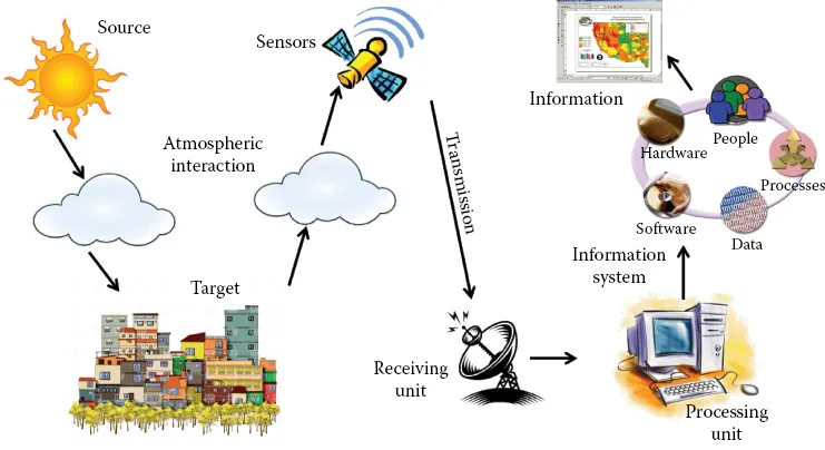
Given the complexity of these technologies and the diversity of application domains, various ultraviolet, optical, infrared, and microwave remote sensing technologies must be used, either independently or collectively, in dealing with different challenges. To achieve a sound system design for remote sensing, the “system-of-systems engineering” (SoSE) approach must often be applied for tackling these complexities and challenges. SoSE is a set of developing processes, tools, and methods for designing, redesigning, and deploying solutions to System-of-Systems challenges (United States Department of Defense, 2008). In support of various types of missions of environmental monitoring and earth observations, the main components associated with a remote sensing system that the system design has to consider include (Figure 1.1): (1) a source of the electromagnetic radiation (i.e., the sun) to be detected by the sensors mounted on air-borne, space-borne, sea-based, or ground-based platforms; (2) the targets to be detected on Earth’s surface which receive the incident energy from a source such as the sun and those targets which emit energy; (3) the quantity and type of sensor instruments to measure and record the reflected and/or emitted energy leaving Earth’s surface; (4) the platforms supporting satellite sensors and payload operations such as altitude, gesture, orbital trajectory control, instrument calibration, power supply, data compression and transmission through digital telemetry, and communication between the receiving station and the satellite or among satellites in a satellite constellation; (5) the receiving station that collects raw digital data or compressed data through a wireless communication network and converts them into an appropriate format; (6) the processing unit in charge of pre-processing the raw data through a suite of correction procedures that are generally performed for generating remote sensing data products prior to the distribution of the products or the imageries; (7) the knowledge discovery or information retrieval to be carried out by professional analysts to convert the pre-processed image data into various thematic information of interest using a suite of image-processing techniques; and (8) the end-user communities who may utilize these thematic products for applications.
Figure 1.1 Basic structure of a remote sensing system.
On many occasions, sensor networks onboard satellites and/or aircrafts are required to provide holistic viewpoints in concert with ground- or sea-based sensors. To further advance Earth system science, such sensor networks can be extended to cover sensors onboard unmanned aerial vehicles (UAVs) and autonomous underwater vehicles (AUVs) to overcome local or regional surveillance barriers. Such expanded sensor networks may be coordinated through proper sensing, networking, and control with the aid of wired or wireless communication systems to produce multidimensional information and to monitor the presence of unique events. The SoSE approach may certainly provide sound routine monitoring, early warning, and emergency response capacity in our society, which is facing climate change, globalization, urbanization, economic development, population growth, and resource depletion.
An integrated Earth system observatory that merges surface-based, air-borne, space-borne, and even underground sensors with comprehensive and predictive capabilities indicates promise for revolutionizing the study of global water, energy, and carbon cycles as well as land use and land cover changes. This may especially be true if these multisensor data fusion and machine learning technologies are developed and deployed in a coordinated manner and the synergistic data are further screened, synthesized, analyzed, and assimilated into appropriate numerical simulation models for advanced decision analysis. Thus, the aim of this book is to present a suite of relevant concepts, tools, and methods of the integrated multisensor data fusion and machine learning technologies to promote environmental sustainability.
1.2Objectives and Definitions
The main objective of this book is to demonstrate the knowledge base for capacity building of integrated data fusion and machine learning with respect to a suite of satellite sensors and machine learning techniques to enhance the synergistic effect of multiscale remote sensing observations and intelligent image processing. The discussion of data fusion in this book is based on a definition derived from the recommendation of the United States Department of Defense Joint Directors of Laboratories (JDL) Data Fusion Subpanel:
The data fusion process proposed by JDL was classified into five processing levels, an associated database, and an information bus that connects the five levels (Castanedo, 2013). The five levels of processing are defined as (Figure 1.2):
•Level 0—Source pre-processing: Source pre-processing allocates data to s...