- 281 pages
- English
- ePUB (mobile friendly)
- Available on iOS & Android
eBook - ePub
Offshore Operations and Engineering
About this book
This book provides a comprehensive understanding of each aspect of offshore operations including conventional methods of operations, emerging technologies, legislations, health, safety and environment impact of offshore operations. The book starts by coverage of notable offshore fields across the globe and the statistics of present oil production, covering all types of platforms available along with their structural details. Further, it discusses production, storage and transportation, production equipment, safety systems, automation, storage facilities and transportation. Book ends with common legislation acts and comparison of different legislation acts of major oil/gas producing nations. The book is aimed at professionals and researchers in petroleum engineering, offshore technology, subsea engineering, and Explores the engineering, technology, system, environmental, operational and legislation aspects of offshore productions systems Covers most of the subsea engineering material in a concise manner Includes legislation of major oil and gas producing nations pertaining to offshore operations (oil and gas) Incorporates case studies of major offshore operations (oil and gas) accidents and lessons learnt Discusses environment impact of offshore operations
Tools to learn more effectively

Saving Books

Keyword Search

Annotating Text

Listen to it instead
Information
1 Introduction to Offshore Operation
1.1 Ocean Baseline
Oceans cover almost three-fourths of the earth’s surface, and the land beneath them can meet the energy requirements of the world for years to come. Beaches extend from the shore into the ocean on a continental shelf that gradually descends to a sharp drop called the continental slope. The continental shelf can be as narrow as 20 km or as wide as 400 km. Water on the continental shelf is usually shallow and rarely more than 150–200 m deep. Continental shelf drops off at the continental slope, ending in abyssal plains up to 3–5 km below the sea level. While many plains are flat, others have jagged mountain ridges, deep canyons, and valleys. The tops of some of these mountain ridges form islands where they extend above the water. Our borders extend 200 miles into the water from coastlines, encompassing areas larger than some countries. This large underwater area is called the exclusive economic zone (EEZ).
Territorial sea baseline is defined by the United Nations (UN) as “the line from which the seaward limits of a State’s territorial sea and certain other maritime zones of jurisdiction are measured”. These zones include the breadth of the territorial sea; the seaward limits of the contiguous zone, the EEZ; and, in some cases, the continental shelf. The territorial sea baseline varies according to the shape of the coastline as follows:
- The normal baseline corresponds with the low-water line along the coast, including the coasts of islands. According to the Convention, a normal baseline can be drawn around low-tide elevations defined as naturally formed areas of land surrounded by and above water at low tide but submerged at high tide, provided they are wholly or partly within 12 nautical miles of the coast [1].
- Straight baselines are straight lines joining specified or discrete points on the low-water line, usually known as straight baseline endpoints. These may be used in localities where the coastline is deeply indented and cut into or where there are a fringe of islands along the coast in the immediate vicinity [1].
- Bay or river closing lines are straight lines drawn between the respective low-water marks of the natural entrance points of bays or rivers.
Territorial sea, being an integral part of the continental shelf, is an important aspect to consider.

FIGURE 1.1 Water according to the United Nations Convention on the Law of the Sea, 1982 [2].
Baselines are the starting point from which the territorial sea and other maritime zones of jurisdiction are measured, for example, contiguous zone, EEZ, and continental shelf (Figure 1.1).
1.2 Ocean Environment
The ocean environment greatly influences the structural design, logistics, and operational safety.
1.2.1 Metocean Condition and Study
Environmental conditions/metocean conditions have a direct bearing on any coastal or offshore project, as well as the project’s operation and maintenance. The selection of equipment, system, location, operational strategy, etc. also depends on these conditions. In addition, environmental conditions influence the financial decision-making regarding the project and operation.
It is essential to understand the environmental/metocean conditions by studying all the parameters, including waves, wind, current, seasonal variation, and probability of cyclones and storms. These studies may be conducted as per the requirements of the job (Figure 1.2).

FIGURE 1.2 Data well waverider buoy deployed near the southwestern coast of France to measure ocean wave statistics, including significant wave height and period, wave direction, and power spectrum [3].
1.2.2 Meteorology
- Wind analysis including speed, direction, gustiness, seasonal variance, and spectrum.
- Air temperature profiling including seasonal variance, humidity, and precipitation.
- Sea water temperature profiling from mean sea level to sea bottom including seasonal variance.
- Sea current analysis.
- Adverse weather analysis including typhoons, hurricanes, cyclones, and tsunamis.
1.2.3 Physical Oceanography
- Sea water level changes including historical, expected, and seasonal tides and wave and storm surge analysis.
- Seiches.
- Wind waves – wind seas and swells – characterized by significant wave heights and periods, as well as propagation direction and spectra (Figure 1.3).
- Bathymetry.
- Analysis of salinity, sea water temperature at different depths, and other parameters.
- Analysis of ice occurrence including extent, thickness, and strength.

FIGURE 1.3 Classification of the wave phenomena – of the sea and ocean surface – according to wave period by Walter Munk [4].
1.2.4 Metocean Data
Metrology and physical oceanography provides the basis for understanding metocean conditions. Metocean data are collected by deploying measuring instruments, through satellites by remote sensing, and by remodeling of existing models including latest inputs. Metocean data form the basis of metocean conditions (Figure 1.4).
1.3 Offshore Oil and Gas Production
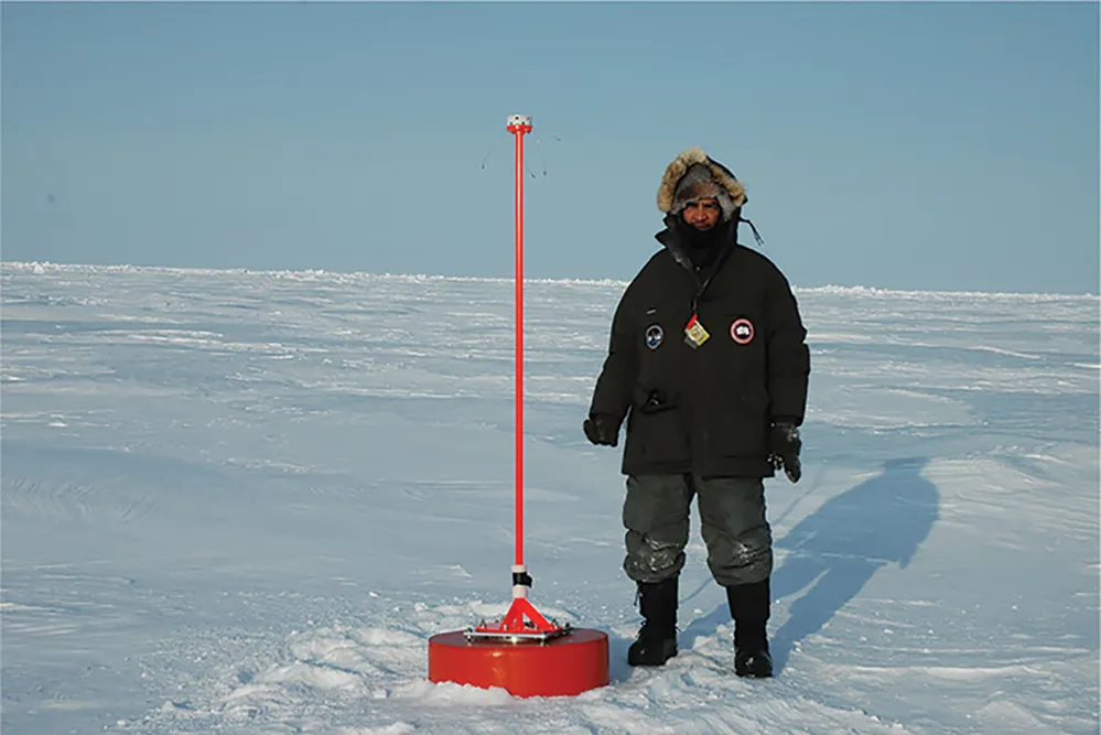
FIGURE 1.4 Ice beacon – for tracking ice movement by GPS, as well as other sensors for measuring more metocean parameters – and Pablo Clemente-Colón of the U.S. National Ice Center [3,5].
To meet the ever-increasing market demand for oil and gas, offshore prospecting and production of oil and gas, apart from onshore production, have become essential. Technological advancements have helped in reaching deepwater sources of oil and gas.
1.3.1 Comparison of Onshore versus Offshore Oil Production
It is clear from Figures 1.5 and 1.6 that, out of the total oil production, 67% is onshore production, and only 33% is offshore production, out of which 24% is from shallow water. Although since 2000 production from deepwater has continuously increased due to technological advancements, deepwater contributes to only 9% of the total production. Thus, to bridge the gap...
Table of contents
- Cover
- Half Title
- Title Page
- Copyright Page
- Table of Contents
- Foreword
- Preface
- Acknowledgments
- Authors
- Chapter 1 Introduction to Offshore Operation
- Chapter 2 Offshore Structure and Design
- Chapter 3 Offshore Drilling and Completion
- Chapter 4 Offshore Oil and Gas Production and Transportation
- Chapter 5 Utilities and Support System
- Chapter 6 Deep Sea Development
- Chapter 7 Offshore Field Development
- Chapter 8 Health, Safety, and Environment in Offshore
- Chapter 9 Legislations and Regulations in Offshore Operations around the World
- Index
Frequently asked questions
Yes, you can cancel anytime from the Subscription tab in your account settings on the Perlego website. Your subscription will stay active until the end of your current billing period. Learn how to cancel your subscription
No, books cannot be downloaded as external files, such as PDFs, for use outside of Perlego. However, you can download books within the Perlego app for offline reading on mobile or tablet. Learn how to download books offline
Perlego offers two plans: Essential and Complete
- Essential is ideal for learners and professionals who enjoy exploring a wide range of subjects. Access the Essential Library with 800,000+ trusted titles and best-sellers across business, personal growth, and the humanities. Includes unlimited reading time and Standard Read Aloud voice.
- Complete: Perfect for advanced learners and researchers needing full, unrestricted access. Unlock 1.4M+ books across hundreds of subjects, including academic and specialized titles. The Complete Plan also includes advanced features like Premium Read Aloud and Research Assistant.
We are an online textbook subscription service, where you can get access to an entire online library for less than the price of a single book per month. With over 1 million books across 990+ topics, we’ve got you covered! Learn about our mission
Look out for the read-aloud symbol on your next book to see if you can listen to it. The read-aloud tool reads text aloud for you, highlighting the text as it is being read. You can pause it, speed it up and slow it down. Learn more about Read Aloud
Yes! You can use the Perlego app on both iOS and Android devices to read anytime, anywhere — even offline. Perfect for commutes or when you’re on the go.
Please note we cannot support devices running on iOS 13 and Android 7 or earlier. Learn more about using the app
Please note we cannot support devices running on iOS 13 and Android 7 or earlier. Learn more about using the app
Yes, you can access Offshore Operations and Engineering by Shashi Shekhar Prasad Singh,Jatin Agarwal,Nag Mani in PDF and/or ePUB format, as well as other popular books in Technologie et ingénierie & Science des matériaux. We have over one million books available in our catalogue for you to explore.