![]() Part 1 Introduction
Part 1 Introduction![]()
Chapter 1 Origins and applications
Introduction
The need to place information in a geographical context pervades many aspects of human activity. In public and commercial organisations, many of these activities are concerned with the recording and planning of the human-made environment, with monitoring and managing the natural environment, with transport and navigation, and with understanding social structures. It is an inevitable consequence of the revolution in information technology that we should attempt to build computing systems to handle this geographical information. The results of these technological efforts are reflected in the fields of geographical information systems (GIS) and computer cartography which are the subject of this book.
When compared with the development of computing systems for maintaining commercial and financial information, progress in the field of geographical information systems has been remarkably slow. One of the earliest clearly identifiable geographical information systems is the Canada Geographic Information System (CGIS), which was developed for planning purposes (Tomlinson, 1985). Although the system can be regarded as having laid the foundations, in the mid 1960s, for many subsequent GIS, it was not in fact followed by a proliferation of similar systems. It was only in the late 1980s that we saw the introduction of proprietary GIS which could claim to meet a significant proportion of the data-handling requirements of organisations concerned with geographical information. Examples of organisations in which these requirements arose include environmental mapping agencies, local and regional government administrations, marketing companies, mineral exploration companies, the military, and utility companies supplying water, electricity, gas and telecommunications.
The relatively late introduction of commercially marketed GIS technology may be explained, to some extent, by the fact that the type of information to be stored in these systems is more complex, and more difficult to process at a basic level, than that found in conventional business information systems. The reasons why geographical data processing is more complex than commercial data processing relate both to the nature of geographical information itself and to the type of retrieval and analysis operations performed upon it. Geographical information is typically concerned with spatially referenced and interconnected phenomena, such as towns, roads and administrative areas, as well as less precisely defined regions with environmental attributes, such as woodlands and marshes. Physical structures and locations are defined by geometric data consisting of combinations of points, lines, areas, surfaces and volumes, in association with classifications and statistical data that attach real-world meaning. These collections of data must be treated in a manner which retains the integrity of the whole objects to which they refer, at different levels of abstraction, rather than as isolated pieces of data. Enquiries on geographical information frequently require some form of spatial search or analysis to be performed on individual regions or on combinations of particular phenomena. Such procedures often require quite sophisticated geometric procedures for manipulation and transformation.
In contrast, commercial data processing can, in general, be reduced to sets of comparative operations on the names or identifiers of, for example, personnel or goods, and to arithmetic operations on attribute values, such as salary and price, which are associated with them. These operations involve less complex algorithms than those required for spatial data. It could also be argued that the development of information technology was initially in response to non-spatial data-processing problems and as such it has been adapted to those requirements. GIS may be seen as one of a number of classes of information processing that require additional layers of special-purpose procedures.
Computer systems for storing and retrieving geographical data are now at a relatively advanced stage of development, but it is still a rapidly developing field and many problems remain to be solved if these systems are to meet all the requirements of spatial analysis and decision-making. Because many organisations need to access a mix of data relating to technical, commercial and human resource issues, a measure of the effectiveness of GIS technology in the future may be the extent to which it becomes absorbed within the information infrastructure and hence disappears as an information processing system in its own right!
In the remainder of this chapter we examine the relationship between GIS and computer cartography, before placing GIS in the context of a range of allied disciplines that have contributed to its development. We then go on to give an overview of the main application areas of GIS and computer cartography. This chapter is intended to provide an appreciation of the uses of GIS before introducing the generic characteristics of geographical information and spatial data models in Chapter 2 and the typical functional capabilities of GIS in Chapter 3.
Cartography and GIS
The fact that geographical information is spatially referenced means that it is associated, at least conceptually, with the field of cartography, as the traditional method of recording the location of spatial phenomena and the relationships between them. The application of computing technology to geographical information handling impacts therefore upon the discipline of cartography. Historically, the development of GIS may be seen to have paralleled efforts to automate cartographic production methods. The growth in the application of GIS technology is now so great however that, to some, cartography appears to be becoming subsumed within the field of GIS. This viewpoint may be understood if we see that the traditional role of cartography has combined the function of helping us understand spatial relationships with that of providing a database recording the form of the earth's surface and the objects located upon it. The introduction of GIS does not necessarily eclipse the role of cartography in the visualisation of spatial knowledge but, as a means of storing, managing and analysing that knowledge, a GIS provides immense benefits when compared to the analogue technology of conventional maps.
Geographical information systems may then be seen to be taking over and greatly extending the role of spatial data storage which was previously played by maps. Once spatial data have been represented in digital form it becomes very much easier to carry out measurements on the data, to perform analyses in various ways, and to make changes to it. Some of the operations can be applied without recourse to a graphic map of any sort. For example, one could enquire about the distance between two named places or, say, the area of coniferous forest within a named county, without referring to a map.
It remains the case however that, for many applications of geographical information, a map may serve for communication purposes as the ideal means of identifying objects of interest and for understanding their spatial properties. In the context of a GIS, an individual map may be seen as one of an infinite number of possible visual symbolisations of the stored data. Thus computer technology opens up opportunities for visualising and exploring spatial data in new ways or in ways that in the past were too expensive or time-consuming to contemplate. This sense of exploration of spatial data through cartography is enhanced when the possibilities of interaction with the map are considered (MacDougall, 1992; MacEachren, 1994). Interactive graphics enable the map to be linked to (non-map) graphical displays of statistics directly associated with the mapped data. Maps may also be regarded as a powerful form of user interface to a wide range of information sources. Thus we can expect to see interactive maps becoming more commonplace in public information systems and networked information resources such as the World Wide Web.
The relationship of GIS to other fields
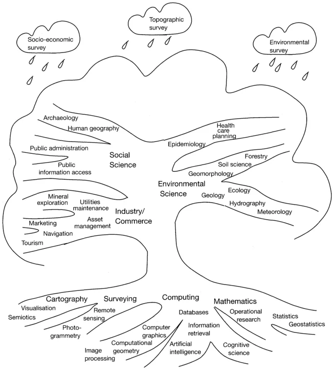
The purpose of the early emphasis here on the close relationship between GIS and cartography is to highlight their common function in storing and communicating geographical information. However, it should be stressed that in general a GIS can be expected to provide tools for data manipulation and analysis, and often for visualisation, which are far more versatile than any associated with traditional cartography. These strengths of GIS for spatial information handling derive from several other disciplines, notably from the fields of computer science, surveying and quantitative geography (Figure 1.1).
From a computing viewpoint, the early development of GIS may be seen to be built largely upon a combination of database technology, for storing information. and of computer graphics for digitising and displaying spatially referenced information. Some of the early GIS included map-overlay facilities which automated procedures used in landscape architecture to evaluate spatial coincidence of environmental and socio-economic factors. These procedures employ
Figure 1.1 The GIS tree. The roots represent the technical foundations of GIS. The branches represent applications of GIS, the results and requirements of which feed back to the roots. Raining down on the tree are the data sources on which the individual applications depend.
techniques from the field of computational geometry, which concerns the development of algorithms to manipulate geometric data. More recently we can see the importance of image processing in interpreting remotely sensed data and of artificial intelligence applied to several aspects of GIS, including image understanding, database design and query languages, planning and automated cartography.
Analytical uses of GIS for understanding spatial patterns and correlations build upon foundations for spatial data analysis and spatial statistics laid down in the 1960s and 1970s by quantitative geographers (Taylor and Johnston, 1995). Despite the subsequent reaction among many geographers and social scientists against the use of quantitative techniques in spatial analysis, the recent improvements in GIS technology and the wider availability of spatial data have resulted in a resurgence of interest in quantitative spatial analysis, particularly in some specific application areas such as epidemiology (deLepper et al., 1995) and in marketing and retailing (Longley and Clarke, 1995).
As GIS become more widely used for decision support in applications such as urban and regional planning, agriculture and the utilities, so the analytical tools of operational research will increasingly become integrated within existing GIS software. In this respect GIS may be seen as an adjunct to management science, and for some organisations the GIS-related functionality may become entirely integrated with a corporate or management information system.
Much of the data used in GIS are derived from topographic, socio-economic and environmental surveys. Because there are large quantities of such data recorded in paper documents, there has been an enormous demand for digitising such documents, which we refer to as secondary digital data acquisition. The largest primary source of digital data for use in GIS is undoubtedly that created by remote-sensing technology on board satellites and other aircraft. The discipline of remote sensing, which deals with the acquisition and analysis of remotely sensed data, is as an important relative of GIS, and from some points of view is regarded as a subdiscipline of GIS. In the future, a progressively higher proportion of acquired digital data will be from primary, ground-based or remote surveys. It is therefore essential for some applications that remote sensing and GIS be closely linked.
Uses of geographical information systems
As the range of information which can be placed in a geographical context is almost infinite, there are in principle few limits to the variety of possible applications of GIS. This is reflected in a continuing growth in GIS usage across many disciplines. It was indicated earlier however that the spur to development of commercial GIS packages has come from a much narrower range of interests among organisations that stand to benefit from the introduction of GIS technology. Major corporate users are found in the utility organisations, and in Western Europe and America there appear to be few local or regional government organisations that do not either currently exploit GIS or express a strong inten...