With an expected population of 400 million by 2040, America is morphing into an economic system composed of twenty-three 'megapolitan' areas that will dominate the nation's economy by midcentury. These 'megapolitan' areas are networks of metropolitan areas sharing common economic, landscape, social, and cultural characteristics.
The rise of 'megapolitan' areas will change how America plans. For instance, in an area comparable in size to France and the low countries of the Netherlands and Belgium – considered among the world's most densely settled – America's 'megapolitan' areas are already home to more than two and a half times as many people. Indeed, with only eighteen percent of the contiguous forty-eight states' land base, America's megapolitan areas are more densely settled than Europe as a whole or the United Kingdom.
Megapolitan America goes into spectacular demographic, economic, and social detail in mapping the dramatic – and surprisingly optimistic – shifts ahead. It will be required reading for those interested in America's future.
A Brief History of the Progression of Thought on How the Built Landscape Is Organized
In this book, we pose a new way of looking at America’s landscape. From its colonial beginnings as a loose confederation of merchant towns, America’s urban landscape has evolved considerably. In this chapter, we synthesize the progression of thought about the urban landscape from the simplistic monocentric urban form to the extended metropolis to megaregions. The next chapter reviews how the Census Bureau has wrestled with defining America’s changing urban landscape in ways useful for its purposes.
We start this chapter with a walk through standard models of city form. We progress to alternative forms that consider how multiple cities create a special region, one that might be called a metropolitan area. As transportation and telecommunication technology has advanced, we find the idea of spatially delimited regions to be anachronistic, so we explore the idea of diffuse regions defined largely by extended commuting sheds. We conclude with concepts of a nation composed of regions defined according to certain shared affinities.
City and Metropolitan Form
Cities are defined by their spatially integrated functions, not by their political boundaries. The suburbs and even exurbs of a city are elements of the city writ large. For instance, the “city” of Atlanta is not the 500,000 people living within its 60-square-mile jurisdictional limits but the extended commuting range, which includes more than 20,000 square miles.
Historically, cities arose because their location gave them least-cost access to farming, or they were at the crossroads of trading routes, or they were least-cost locations from which to ship goods, often by water. Cities arose mostly in isolation from one another, dominating surrounding trade areas. Over time, successful cities grow because of agglomeration and scale economies. Many become major, independent centers of commerce and manufacturing, such as modern-day Atlanta (McCarthy and Knox 2005). Others grow into each other, creating multicity regions that share interdependencies. Jean Gottmann’s (1961) megalopolis, extending from Boston to Washington, D.C.—called “BosWash” by some—is an example.
Cities also sort themselves into a hierarchy of trading areas, with the largest cities being in the center, where they are also closest to all other cities. This is known as the hierarchy of markets comprising a “system of cities,” conceptualized by Christaller (1933) and Lösch (1954). The “system” can be at any scale. For instance, in the Northeast, New York City would be the dominant or “capital” city, while Philadelphia and Boston, both of about equal size and distance from New York, would be secondary or “regional” cities. (This is only a schematic representation, however, since ocean port cities do not extend into the ocean.) For the nation as a whole, New York would remain the capital city in a system of cities, but the major second-tier regional cities across the breadth of the continent would be Chicago and Los Angeles. At a smaller scale, systems of cities form metropolitan areas, usually with a central city at the geographic center of accessibility.
While the hierarchy of cities describes how they arise, how they are organized internally is another matter. We will not review the evolution of city form but instead focus on different conceptualizations of that form since the early 20th century with the advent of modern transportation and telecommunication technologies. There are three general city forms: concentric ring or monocentric, sector, and multinuclear or polycentric.
Concentric Ring or Monocentric City and Metropolitan Form
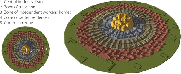
Park, Burgess, and McKenzie (1925) applied natural ecology to urban areas and created the urban ecology school of thought. Their theory describes what happens when a city grows. Generally, growth results in more activity in the downtown area, pushing it outward. As the downtown area penetrates the next ring, it absorbs or overtakes the business activities, terrain, and population, becoming spatially larger. At the same time, activities in the invaded zone grow because of overall growth and invade the next ring, succeeding uses that were previously there. The overall process extends the city outward and, with modern technology, results in an extensive commuting zone surrounding the built-up area. Figure 1.1 illustrates the theory. In Chicago, the concentric theory of growth seems to explain the distribution of land uses that creates the city’s overall form.
Figure 1.1. Concentric ring theory of urban form Credit: Doug Woodruff
Sector City and Metropolitan Form
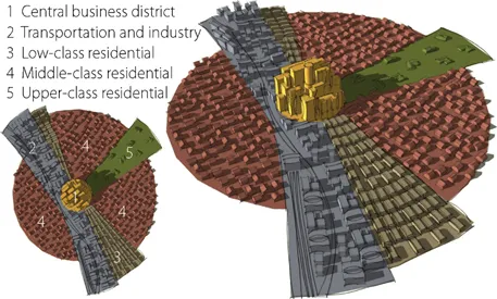
Cities are more complex than the simple model conceptualized by Park, Burgess, and McKenzie. To further understanding of city form, Hoyt (1939) conceptualized the sector theory. Generally, cities organize themselves around a center not in concentric rings but in sectors, as illustrated in Figure 1.2. Sometimes this occurs because of geography, but more often it occurs as a natural ordering of land uses based on principal uses. For instance, manufacturing and warehousing might occur along riverfronts (as in early Pittsburgh) or along railroads (as in early Atlanta). Residential areas in particular would sort themselves out demographically by race or socioeconomic class (or both) based substantially on income. Early on, a “favored” sector might emerge. Many factors facilitate the rise of a favored quarter; some important ones include elevation above flood-prone or polluted lowlands, location upwind from manufacturing plants, and the original settlement of upper-class families away from downtown. For instance, in Atlanta, Georgia, there was a settlement north of downtown called Buckhead where business and financial leaders chose to live in the mid-1800s when Atlanta had but a few tens of thousands of residents. Buckhead was a few miles away from the railroads that terminated in downtown (Atlanta’s original name was Terminus) and slightly elevated from downtown itself. Almost two centuries later, Atlanta’s favored sector has created a kind of northern arc that has been dubbed the “favored quarter” in recent times (Leinberger 1995).
Figure 1.2. Sector theory of urban form Credit: Doug Woodruff
Multinuclear or Polycentric City and Metropolitan Form
As urban areas grow and transportation costs decline, new, satellite suburban centers rise up, leading to multiple centers, or what some call a polycentric city form. Harris and Ullman (1945) were the first to conceptualize this form (Figure 1.3).
Vance (1964, 1977, 1986) expanded on the polycentric form to characterize large urban areas as composed of “urban realms” (Figure 1.4). Vance points out that the large geographic scale of modern urban areas limits personal routine interactions (for shopping, personal services, and social networks) to smaller areas, which he calls “realms.” Realms often have their own large commercial centers and, as we observe, a population base within a defined geography of about one quarter to one million people. The geographic space is defined by terrain and topographic barriers, the overall size of the metropolitan area, the amount and type of economic activity the area can support, and the geography of transportation within the region, such as the presence of transit nodes, freeway interchanges, and the like.
A variant of the polycentric form, and of the urban realm concept, is the edge city (Figure 1.5), popularized by Garreau (1991). Edge cities are seen as completely automobile-driven, suburban activity centers comprising more than five million square feet of office space, more than 600,000 square feet of retail space, having more jobs than bedrooms, perceived by the local population as a definable place, and could not have had any urban features 30 years earlier. Some well-known edge cities include Tysons Corner in suburban northern Virginia, King of Prussia in suburban Philadelphia, the Galleria in suburban Houston, Bloomington in suburban Minneapolis–St. Paul, and Bellevue in suburban Seattle. L...
Table of contents
Cover
Half Title
Title Page
Copyright Page
Dedication
Table of Contents
List of Figures
List of Tables
Foreword
Acknowledgments
Prologue: From Cities to Megapolitans
1 From Cities to Megaregions
2 Megapolitan Covergence: Soft-Nosed Planning and the New Regional Governance
3 Defining What Is Megapolitan
4 The Rural-Megapolitan Continuum
5 Megapolitan Areas as America’s New Economic Core
6 Megapolitan Attractiveness
7 Key Population Trends
8 Megapolitan Development
9 Transportation Planning and the Megapolitans
10 Implications of Megapolitan America for Land, Water, and Air Resources
11 Cascadia Megapolitan Cluster
12 Sierra Pacific Megapolitan Area
13 Southwest Megapolitan Cluster
14 Mountain Megapolitan Cluster
15 Texas Triangle Megapolitan Cluster
16 Twin Cities Megapolitan Area
17 Great Lakes Megapolitan Cluster
18 Florida Megapolitan Cluster
19 Piedmont Megapolitan Cluster
20 Megalopolis Megapolitan Cluster
Epilogue: The Megapolitan Century
Appendix: From Urban to Metropolitan
Notes
References and Selected Bibliography
Index
Frequently asked questions
Yes, you can cancel anytime from the Subscription tab in your account settings on the Perlego website. Your subscription will stay active until the end of your current billing period. Learn how to cancel your subscription
No, books cannot be downloaded as external files, such as PDFs, for use outside of Perlego. However, you can download books within the Perlego app for offline reading on mobile or tablet. Learn how to download books offline
Perlego offers two plans: Essential and Complete
Essential is ideal for learners and professionals who enjoy exploring a wide range of subjects. Access the Essential Library with 800,000+ trusted titles and best-sellers across business, personal growth, and the humanities. Includes unlimited reading time and Standard Read Aloud voice.
Complete: Perfect for advanced learners and researchers needing full, unrestricted access. Unlock 1.4M+ books across hundreds of subjects, including academic and specialized titles. The Complete Plan also includes advanced features like Premium Read Aloud and Research Assistant.
Both plans are available with monthly, semester, or annual billing cycles.
We are an online textbook subscription service, where you can get access to an entire online library for less than the price of a single book per month. With over 1 million books across 990+ topics, we’ve got you covered! Learn about our mission
Look out for the read-aloud symbol on your next book to see if you can listen to it. The read-aloud tool reads text aloud for you, highlighting the text as it is being read. You can pause it, speed it up and slow it down. Learn more about Read Aloud
Yes! You can use the Perlego app on both iOS and Android devices to read anytime, anywhere — even offline. Perfect for commutes or when you’re on the go. Please note we cannot support devices running on iOS 13 and Android 7 or earlier. Learn more about using the app
Yes, you can access Megapolitan America by Arthur Nelson,Robert Lang in PDF and/or ePUB format, as well as other popular books in Architecture & Urban Planning & Landscaping. We have over one million books available in our catalogue for you to explore.