1.1 Physical and cultural factors
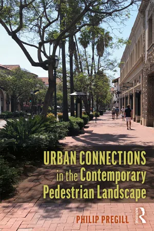
Urban contexts are undergoing contemporary transformations, with distinctive consequences for pedestrian street connections, including arterials, collectors, and locals. The urban landscapes associated with these connections exist within a hierarchy of streets influenced by form, scale, surfaces, edges, and places. Each connection contains degrees of influences, the sum of which affect identity and aesthetics. The distinction of each connection derives from inherent physical and cultural factors. Topography, hydrology and materials interface with existing land uses, architectural typologies, and walkability strategies, and are all influences on existing pedestrian connections. Ultimately, the quality of urban connections is the result of the intersection of physical and cultural factors along with contemporary design applications in the hierarchy of street connections. Boulevards, avenues, and alleys are locations defined by particular scales, from urban to human, with specific contemporary applications, all offering spatial diversity for enhanced pedestrian experience.
In some instances, the existing physical and cultural factors produce dramatic events in urban connection contexts. The annual presence of acqua alta in Venice, Italy’s Piazza San Marco is an example of a unique connection context and experience influenced by the intersection of the subsiding topography and the rising waters of the Venice Lagoon. The consequent effect of these topographic and aquatic conditions on the historic Venetian site continues to produce diverse images of the piazza, with ongoing influences on the identity of the historic social space. Alternately, in more stable geographic settings, the order of urban physical and cultural factors may furnish consistent and subtle experiences for pedestrians. For example, a line of street trees along a retail avenue may seem fairly routine during mid-day. However, depending on the orientation of the street, the tree line may render strong shadow patterns in the morning and afternoon at particular moments during the seasons, while furnishing useful information for pedestrian orientation and movement.
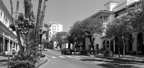
Figure 1.1Contemporary streets are a synthesis of physical and cultural elements and are the contexts that influence pedestrian experience.
Each connection context within an urban street hierarchy provides a range of experiences for pedestrians. Along local street connections, the framing effect of a narrow alley may bring into focus a visual terminus or a distant view of a hillside with a unique vegetation pattern. Less stimulating may be an arterial boulevard along a routine urban industrial district defined by stark surfaces that convey a harsh reflection of sunlight during mid-day. As pedestrians walk through an urban setting, the range of visual events provides an overall sense of the detail of the contexts along the connections. At the conclusion of a walk, pedestrians possess the experiential data to render aesthetic judgments about the quality of the connections, and potentially contribute opinions regarding the overall identity of the streets. Such experiences began centuries ago with the development of urban order through the utilization of the orthogonal grid configuration in regions experiencing the shift from hunting and gathering to permanent settlement during the agricultural revolution. Today the urban grid configuration is a prime model for communities around the globe.
1.2 Connections: history and function
An important element in the evolution of settlements and pedestrian experience was the eventual appearance of rational street configurations. The change began with communities during the Neolithic age, when settlements first appeared in the Near East and Asia. Initially these communities were modest in scale and architectural composition. With gradual expansion of settlements and the need for enhanced connections, irregular circulation patterns were eventually replaced with orthogonal patterns in communities where the influence of the agricultural revolution was a significant factor in the development of settlements. Over the millennia, the grid strategy of street order has become a common application around the world. An example of this transformation was the appearance of the grid street order in early settlements in the West, ultimately leading to the theories of Hippodamus of Miletus, during the Greek colonization of the Mediterranean region between 450 and 300 BCE.
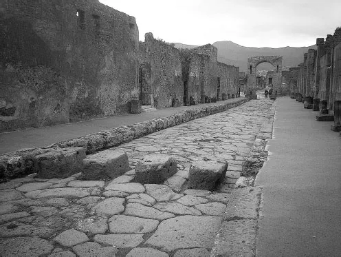
The basic orthogonal logic of the Hippodamian urban grid has eventually become an influence in many urban settings, East and West. From Classical times to the present day, the grid arrangement of urban circulation has engaged a variety of geographical settings, from level terrain to steep slopes. Priene, a Hippodamian influenced community dating from the fifth century BCE, possessed a rational grid order of circulation aligned along an existing slope. The result was the appearance of a rational configuration defined by a hierarchy of pathways, from primary streets to local lanes, with each contributing to an efficient arrangement of circulation for a variety of urban functions. The once populated Greco-Roman city of Pompeii near Naples, Italy is a distinctive reference to the order of the orthogonal order of Mediterranean communities organized on the rational configuration of the grid. Efficiency, orientation, livability, and comprehensible street hierarchy became the norm in many locations during the classical era. Over time, the grid has furnished pedestrians with an established order of circulation within a range of urban locations, through periods defined by cultural challenges and accomplishments.
Figure 1.2The orthogonal grid configuration in historic Pompeii, Italy provided efficient pedestrian circulation for several hundred years.
The effect of physical and cultural influences continues to appear in the grid configurations of modern cities and towns. In San Francisco, California, where the grid and local topography intersect, the result is an urban geography with a distinctive meaning for the current identity of the city. In locations with less topographic variety, the urban grid arrangement provides an equally effective order, livability, and identity to urban street contexts. Orientation, safety, and walkability all characterize current urban grid contexts, while enhancements occur in response to the increased presence of pedestrians in cities committed to advancing walkability and livability. A current contemporary example of this agenda is the recent adaptation of technology related to urban data and pedestrian presence and circulation in street contexts. The responses derive from technological applications aimed at enhancing pedestrian access and livability within urban contexts, and include the evolving Complete Streets initiative.
Though the grid format was the model for most newly established communities throughout much of the territory ruled by the Greeks and Romans, not all settlements affected by Roman authority maintained the logic of the grid after the fifth century in Western Europe. During the Middle Ages, the Roman logic of many settlements reverted to a less orthogonal organization. Those communities that made it through the Middle Ages to the present day provide unique pedestrian experiences derived from an era rooted in diverse urban street logics based on inductive and deductive influences. Examples include existing medieval hill towns in central Italy, including Siena and San Gimignano, both of which evolved through the Middle Ages to the present day as prime examples of communities possessing a mix of urban street arrangements. By the fifteenth century, some communities, including the former medieval town of Pienza in Tuscany, featured a subsequent transformation of the circulation order of the Medieval form to the Renaissance rational order, based on the logic of the orthogonal street order.
For the past two millennia, the grid configuration has influenced urban form in numerous societies and continues to be an influence on the order of urban settings in many regions around the globe (Kohlsted, 2018). In areas of the Americas during European exploration, countries including Spain and Portugal conformed to the Laws of the Indies by establishing settlements in the Americas arranged along the rational grid model (Rodriguez, 2013). Since the era of European exploration, the grid has provided a logical format for pedestrians to maintain a sense of orientation and direction, as they walk from one location to another. These include streets with visual connections to distant hillsides and vegetation patterns, in contrast to building facades and their detailed surface qualities as sources for orientation and direction. Regardless of the topographic setting and cultural function, the urban grid order continues to furnish a spatial logic, with a sense of orientation for pedestrians walking along urban street connections from points of origin and destination.
The experiential references in current urban settings also often engage a range of cultural expressions. For example, older urban grids convey the history of their connections, including avenues and collectors constructed in some locations during the nineteenth century possessing unique forms and materials. More recent grid contexts with their contemporary structures and details provide connections with a range of diversity in form and scale, including structures that step back at the second or third story level, thereby widening the visual dimension of a potentially relatively narrow avenue. In certain locations, the amount of visual information may be relatively discrete, and require a moment of observation and interpretation. In other instances, the range of information may approach a point of overload, with consequences for subsequent orientation, interpretation, and identity.
In every instance, past or present, specific factors derived from the intersection of physical and cultural conditions have produced unique contexts for pedestrian experiences. From a street layout and its relation to existing topography, to the orientation of building surfaces to daily sunlight angles, the intersection of physical and cultural factors ultimately contributes to the identity of an urban context. In current urban contexts, these visual events constitute the potential range of experiential data available to pedestrians, including points of interest and potential aesthetic experiences. Within the range of visual references, pedestrians are able to interpret their engagement of urban contexts through sensory experience derived from innumerable influences. Both top-down and bottom-up information derived from the quality of street contexts continue to influence the potential range of context quality and subsequent pedestrian engagement (Smedley, 2013). In sum, the grid order of urban circulation supports a range of spatial settings, each with a particular function and image. The opportunity for communities is to recognize the resources that they possess as bottom-up opportunities for the ongoing evolution of their respective cities and towns.
Ultimately, grid contexts provide the location for routine and notable moments of pedestrian experience, based on the existing quality of the connection hierarchy. Common contributors to the quality of streets include five spatial influences, which provide subjects for discussion in the text, including form, scale, surfaces, edges, and places. The selection of the five influences derives from the presence of the influences in documents related to quality and enhancement of urban connections. Spatially, each influence occurs routinely in the hierarchy of urban connections and helps define the individual and overall quality of arterials, collectors, and locals. Collectively, these spatial influences, along with their specific contemporary applications, provide substance for the sense of place, identity, and aesthetic moments, all influences on pedestrian experiences in urban connections.
Currently, many communities, faced with the prospect of increased populations and the consequent need to enhance livability and walkability within their urban contexts, are adopting contemporary planning and design strategies. For many cities and towns, the challenge is to direct the ongoing transformation of urban connections and contexts towards planning and design outcomes that include inductive and deductive applications with positive results for pedestrian experience. As more individuals choose to locate in urban settings, the demand for connection qualities responsive to livability and walkability will continue to call for strategies that promote change while preserving unique urban qualities. In the following chapters, the function and opportunities related to street enhancements relate to both formal public planning processes and to independent contemporary adaptations, influenced by the Complete Streets and smart streets agendas. These and other entities will continue to provide directions for the ongoing evolution of the urban street contexts (Smart Growth America, 2018).
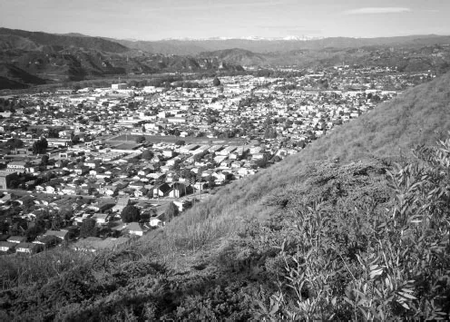
Figure 1.3The orthogonal grid arrangement continues to provide order and safety in many communities, while providing the basis for walkability and livability in urban contexts.
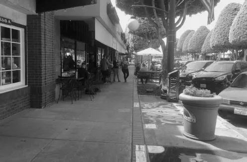
1.3 Function and opportunities
A prime characteristic of the grid arrangement is the function of urban linkages, including arterials, collectors, and local connections. Each connection plays a role in linking pedestrians to points of origin and destination, aided by local and global orientation references, such as landmarks and close-range details. As streets, the three levels of connection are defined by specific street titles. Arterials generally refer to boulevards and, occasionally, avenues. Collectors include both major and minor avenues, while locals consist of alleys and side-streets. Arterials are usually urban connections that join major transportation links—highways and transit lines—to avenue collector streets. Avenues then provide pedestrian and vehicular linkage to local connections, including alleys and local side streets. Local connectors, particularly alleys, are evolving as locations for personal human-scale experience enhanced by social spaces, green spaces, and fine art. In sum, the hierarchy of the three collectors are the essential linkages throughout an urban district, and are the focus of community planning and design related to standards and opportunities.
Figure 1.4Current streets are evolving to serve pedestrian presence and use, including street seats, art interventions and bottom-up influenced paving materials.
As potentially efficient connections within urban contexts, street hierarchies rely on a range of spatial influences, including form, scale, surfaces, edges and places. For example, arterials have an order and sense of scale distinct from the personal human scale of a mid-block lane or a local alley. Arterials, with their cross-street dimensions, often include lines of street trees, along with medians utilized for storm water management and as pedestrian islands. Specific features such as street seats, parklets, and pop-ups also occur within the hierarchy of arterials, collectors, and local connections and afford a range of visual dimensions and depth of field to pedestrians. Recent enhancements of arterials in response to transportation requirements have promoted the development of pedestrian alternatives for attaining efficient connections. A prime feature are mid-block cross walks with pedestrian refuge islands along medians. Avenues are the intermediary connections between arterials and locals, and often are the most intense locations for pedestrian places and activities. Street seats, curb extensions, and temporary interventions respond to pedestrian preferences and requirements and are contributing to the contemporary order of avenue collectors. The third level of connection includes local alleys and local streets with their personal human scale of spatial proportion. The inherent enclosure of alleys is ideal for the presence of intimate spaces and details, including advantages for murals and other fine art applications, along with social spaces and places for repose.
The consequence for pedestrians utilizing urban connections is a physical dimension of visual experiences distinguished by the form and detail of arterials, collectors, and local connections. As the accommodation of pedestrian activities continues to evolve in urban settings, the challenge for planners and designers is to refine existing connect...