
- 346 pages
- English
- ePUB (mobile friendly)
- Available on iOS & Android
eBook - ePub
About this book
London is a living architectural exhibition. This tried and trusted portable guide will help you to find your way around one of the world's most exciting cities, offering architectural experiences and insights into London's finest contemporary architecture.
- features more than 400 buildings including key venues from the 2012 Olympic Park
- provides a superb full colour photographic record of the capital
- aids navigation of the city's greatest architectural sights with a clear map-based format
- considers each district in turn, identifying the buildings most worthwhile visiting, and providing essential information and insights into each
- includes a large scale, portable, lightweight map, for use when walking the tours
Jam packed with the author's intimate architectural experience and knowledge of London's buildings, the accompanying commentary is both lively and entertaining, providing all the information that any architectural explorer will need to appreciate and experience London's contemporary architecture.
Trusted by 375,005 students
Access to over 1 million titles for a fair monthly price.
Study more efficiently using our study tools.
Information
Topic
ArchitectureSubtopic
Architecture GeneralThe City: London’s Historic Core
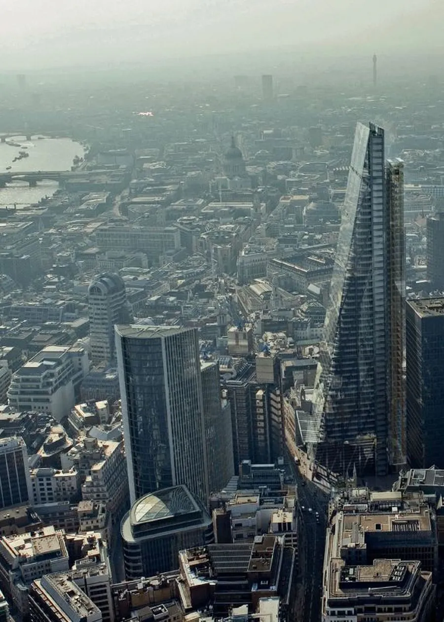

The symbolic and geographical heart of the City is at Bank – the location of the Bank of England. Traditionally, one was meant to have a respectable address that lay within a ten-minute walk of Bank – which is, more or less, the distance to the old Roman wall that wrapped the City from the Tower of London to Blackfriars (built about AD 200 and mostly demolished in the 18th and 19th centuries).
For most of its history City inhabitants turned their backs on the River Thames, its shipping and warehouses. This introverted character did not alter until the mid-1980s when, during the so-called ‘Big Bang’ of banking deregulation, the City expanded in every direction: pushing out, going upward and even leap-frogging across the River Thames. Today, the inner heart of the City is a conservation area of office buildings littered with old graveyards and churches, many of them by Wren and built between 1670 and 1700. And, around that heartland is a series of fringe areas with quite different characters. Overall, the area is increasingly like a set of concentric circles centred on Bank.
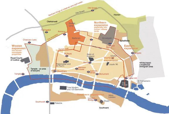
• The eastern geographic boundary is Farringdon Road, beyond which is Fleet Street, an area occupied by lawyers since the Middle Ages (Temple). When the newspapers left in the 1970s and 1980s, the sites of printing works became office buildings (what estate agents incongruously like to call ‘Mid-Town’).
• To the north-west is Smithfield and Clerkenwell – land of architects, designers and furniture showrooms. The Barbican and Golden Lane estates are here.
• Further around, to the north-east, is Broadgate and the peculiarity of Shoreditch and Hoxton: a mostly run-down area of high rents the government and estate agents would like to label ‘Tech-City’. The Sunday Colombia flower market is in this area.
• Hoxton quickly becomes a traditional area of immigration that forms the eastern boundary between the bankers and a Bangladeshi community – an area including Spitalfields and Brick Lane.
• Following around, we come to the Tower of London and St Katharine’s Dock, and then – across the River Thames – More London and a strip of regeneration that includes Southwark Cathedral and the Tate Modern, bringing us back to Blackfriars Bridge.
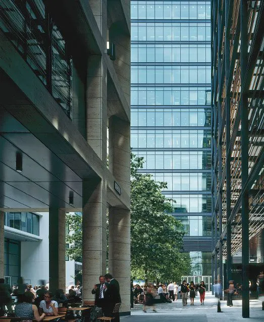
Photo: courtesy of Bennett Associates (Peter Cook)
New Street Square, Fetter Lane, by Bennett Associates – an instance of westward expansion and one of the City’s more outstanding recent developments (2009). The Square is located on the edge of the district of lawyers that sits between the City and the West End, comprising disparate buildings by the same architect, set around a simple urban square. It has been noted that some ground-floor areas are unnecessarily grand and largely empty entrance lobbies that achieve very little for anyone (and for which the architect was not responsible), but this is otherwise an admirable urban development. Beware of security guards eager to inform you that a photograph can’t be taken within the boundaries of the development – what looks public but is, in fact, private, as are many such developments in London. In fact, there is no curtailment of photographing as such. Simply walk to the perimeter, to a public pavement, and photograph from there. (Yes, it is all rather silly.)
Note: being adjacent to one another, these areas can overlap and are simply meant to identify an area’s character and groupings of buildings.
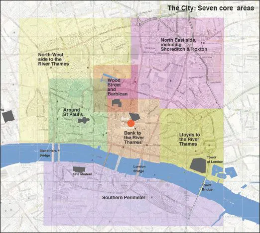
We have divided the area in and around the City of London into eight subgroups and provided a small local map for each area. The south, north-east and west are mixed fringe areas.
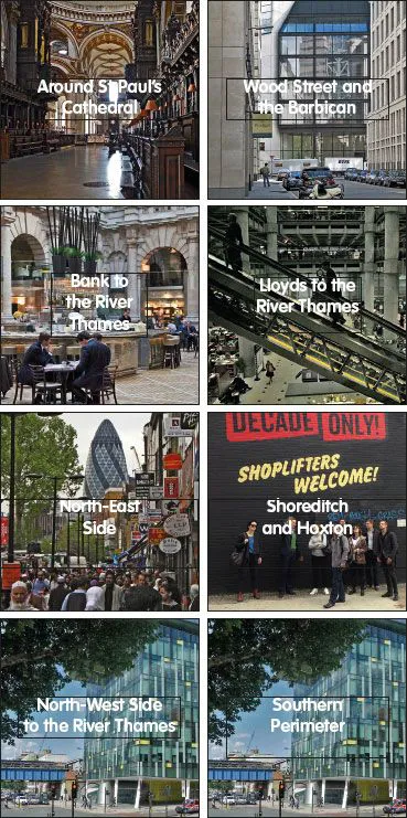
1. Around St Paul’s
Including Paternoster, One New Change, etc.
2. Wood Street and the Barbican
This group is centred where the old Roman fort was located and includes buildings by Rogers, Foster, Farrells, Grimshaw, etc., including the Barbican and Golden Lane housing (where most of the City population lives).
3. Bank to the River Thames
From the geographical heart of the City to the river.
4. Lloyds to the River Thames
This area is centred on a group of tall buildings near to the Lloyds ‘86 building, going down to the River Thames.
5. North-East Side
The northern edges of the City and its expansion to the north-east around Broadgate, toward Spitalfields. It is centred on the Broadgate development and on the Shoreditch triangle.
6. Shoreditch and Hoxton
The fringe area to the very north-east of the City, centred on ‘The Shoreditch Triangle’.
7. North-West Side to the River Thames
This is really an extension of the northern part of the City, as it runs into Islington and Hackney boroughs. It also extends westward into Fleet Street and Smithfield areas.
8. Southern Perimeter
This group covers the exceptional extension of office buildings over the river, especially to Bankside 123 and to More London. It includes the Tate Modern on the west side and the mixed former docklands area of Butlers Wharf to the east of Tower Bridge.
The City: Around St Paul’s Cathedral
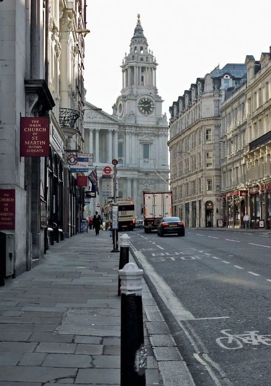
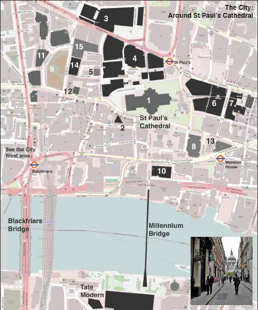
Most things in this area have to do with St Paul’s and its dome – a more potent symbol to Londoners than, say, the Houses of Parliament. From this area one can go in three principal directions: south, across the Millennium Bridge, to the Tate Modern and other buildings in that area, south of the River Thames; north-east, to the Wood Street area; or eastward, toward the Bank group.
Going westward leads into Fleet Street and the Inns of Court. Going north leads to Smithfield and Clerkenwell (an area dense with architectural practices).
It is worth noting that ‘the Square Mile’ is currently linked to one in six jobs in the capital; that 9200 people currently live within the City boundary and that 340,000 people work there.
1. St Paul’s Cathedral
Christopher Wren, 1700
Ludgate Hill, EC4
Tube: St Paul’s
London has many important buildings of historic importance, but one of them – St Paul’s Cathedral – is also of deep contemporary significance. Until comparatively recently, the church dominated London’s skyline – hence protection by a series of ‘strategic viewing corridors’ and height controls all around its location, all set within a ‘view management fram...
Table of contents
- Cover
- Title Page
- Copyright Page
- Dedication
- Table of Contents
- This 6th Edition
- The City: London’s Historic Core
- Going East from the City
- The West End
- North Central
- West Central
- South Central
- Index of Architects and Buildings
Frequently asked questions
Yes, you can cancel anytime from the Subscription tab in your account settings on the Perlego website. Your subscription will stay active until the end of your current billing period. Learn how to cancel your subscription
No, books cannot be downloaded as external files, such as PDFs, for use outside of Perlego. However, you can download books within the Perlego app for offline reading on mobile or tablet. Learn how to download books offline
Perlego offers two plans: Essential and Complete
- Essential is ideal for learners and professionals who enjoy exploring a wide range of subjects. Access the Essential Library with 800,000+ trusted titles and best-sellers across business, personal growth, and the humanities. Includes unlimited reading time and Standard Read Aloud voice.
- Complete: Perfect for advanced learners and researchers needing full, unrestricted access. Unlock 1.4M+ books across hundreds of subjects, including academic and specialized titles. The Complete Plan also includes advanced features like Premium Read Aloud and Research Assistant.
We are an online textbook subscription service, where you can get access to an entire online library for less than the price of a single book per month. With over 1 million books across 990+ topics, we’ve got you covered! Learn about our mission
Look out for the read-aloud symbol on your next book to see if you can listen to it. The read-aloud tool reads text aloud for you, highlighting the text as it is being read. You can pause it, speed it up and slow it down. Learn more about Read Aloud
Yes! You can use the Perlego app on both iOS and Android devices to read anytime, anywhere — even offline. Perfect for commutes or when you’re on the go.
Please note we cannot support devices running on iOS 13 and Android 7 or earlier. Learn more about using the app
Please note we cannot support devices running on iOS 13 and Android 7 or earlier. Learn more about using the app
Yes, you can access London's Contemporary Architecture by Ken Allinson,Victoria Thornton in PDF and/or ePUB format, as well as other popular books in Architecture & Architecture General. We have over one million books available in our catalogue for you to explore.