This book explains how with careful planning and design, the functions and performance of constructed wetlands can provide a huge range of benefits to humans and the environment. It documents the current designs and specifications for free water surface wetlands, horizontal and vertical subsurface flow wetlands, hybrid wetlands and bio retention basins; and explores how to plan, engineer, design and monitor these natural systems.
Sections address resource management (landscape planning), technical issues (environmental engineering and botany), recreation and physical design (landscape architecture), and biological systems (ecology). Site and municipal scale strategies for flood management, storm-water treatment and green infrastructure are illustrated with case studies from the USA, Europe and China, which show how these principles have been put into practice.
Written for upper level students and practitioners, this highly illustrated book provides designers with the tools they need to ensure constructed wetlands are sustainably created and well manage
Trusted by 375,005 students
Access to over 1 million titles for a fair monthly price.
This book addresses the intersection of development (both rural and urban), and the supply and quality of water required to sustain it. Sustainable development must include water quantity and quality as indicators applied to both human and ecosystem health. Furthermore, these indicators must be considered across the full range of human land uses, including urban, agricultural and industrial. In the planning for new urban centres, green infrastructure exhibits its potential as a continuous network of urban and natural spaces connected by ecological corridors. These linear and nodal green spaces structure the residential and commercial uses of the city while contributing many ecosystem services, such as pollution mitigation and provision of recreational open space. When a green infrastructure network is combined with high-density development, then compact, high-quality human environments are created (Austin, 2014).
Municipal master planning
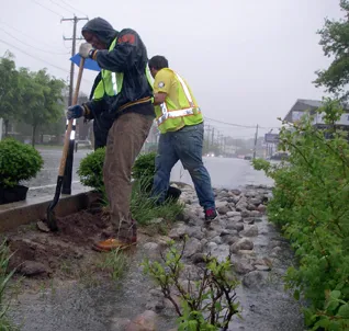
Establishing sustainable water use is more readily attainable when water supply and treatment infrastructure are incorporated into master planning. Retrofitting existing cities to achieve more sustainable use and disposal of water is possible, but requires intensive, coordinated efforts by government agencies and citizens through years of consistent effort. The city of Philadelphia, United States, is an example of a city with an aging infrastructure engaged in this difficult but economically advantageous process today. The $1.2-billion-dollar plan will require 25 years to complete, but will save the city $5.6 billion by eliminating the need for new conventional wastewater treatment plants, upgrades to existing plants and conventional stormwater infrastructure. This effort includes constructed wetlands and other measures to convert one-third of the city’s impervious surfaces to pervious conditions to reduce stormwater contributions to the city’s combined stormwater and sanitary sewer infrastructure (Figure 1.1). Ultimately, the amount of stormwater entering Philadelphia’s waterways will be reduced by 85 per cent (Philadelphia Water Department, 2015).
An example of green infrastructure master planning is in the city of Wuhan in the Hubei province of central China. Wuhan has a rapidly expanding population of more than 10 million people. The city receives about 47 inches (1,200 mm) of rainfall per year, much of it during the hot summer months. In east Wuhan, an area of 6.2 square miles (10 km2) has been designated for a new town named Wulijie. The gently rolling topography of the new town will be the home of 100,000 residents. The existing valleys and ponds will form the basis of a surface stormwater collection and treatment network. Retaining and treating the increase in run-off created by urban buildings and paving are important to preserve the high water quality of Liang Zhi Hu Lake, which is downstream to the east (Saunders and Yu, 2012).
Figure 1.1 The city of Philadelphia is engaged in a citywide campaign to divert stormwater run-off into infiltration areas rather than into the combined stormwater and sanitary sewer system.
Photo: Philadelphia Water Department. www.flickr.com/photos/philadelphiawater.
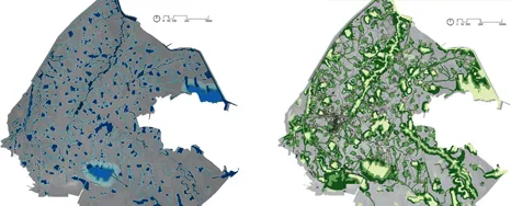
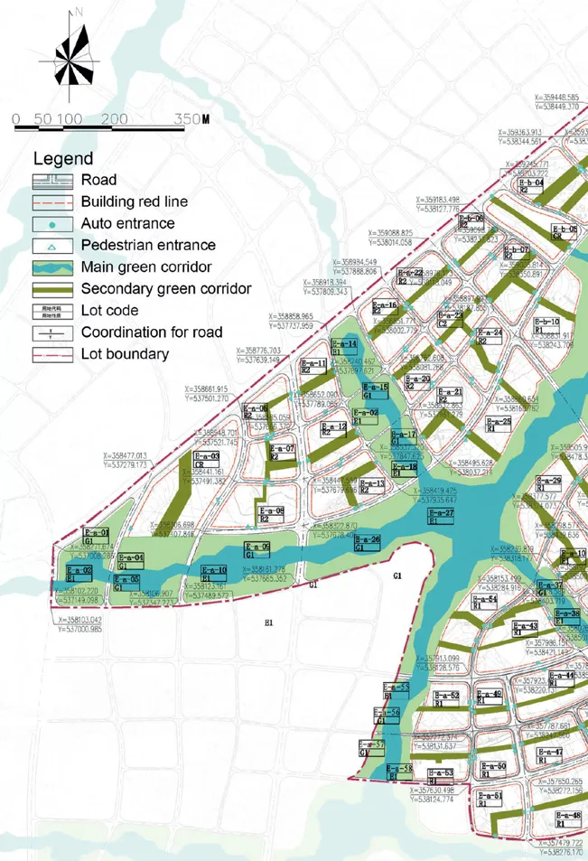
Figure 1.2 shows two sensitivity maps for the proposed development area. One studies the hydrology and the risk of flooding, while the second considers the habitat value and cultural sites. A composite of these plans led the planners to the configuration of the residential and commercial development blocks as well as the transportation network. Public transportation, pedestrian and bicycle systems were an integral part of the planning from the outset.
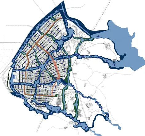
The development plan is structured by three types of corridors. In Figure 1.3, the three corridor types are distinguished by width and clearly establish the form and scale of the new town districts. The orange line indicates the major vehicular transportation routes.
The hierarchy of corridors specified in the master plan will accommodate increasingly greater stormwater run-off volumes. The tertiary corridors (Figure 1.4) are 50–100 feet wide (20–30 m); they receive stormwater from the development parcels and overflow to the larger corridors. The secondary corridors (Figures 1.5 and 1.9) are 200–300 feet wide (60–90 m); they subdivide the development blocks and deliver moderate stormwater flows to the major water corridors. The widest corridors (Figures 1.6, 1.7 and 1.8) are 400–500 feet (120–150 m), which define the perimeter and major development sections.
The width of the corridors (Figure 1.10) planned at Wulijie exceeds the minimum width recommended by ecological research and green infrastructure planning (Austin, 2014), which suggests minimum widths and lengths for ecological corridors. The recommendations vary according to the context, but in a low-density residential district, the minimum recommended width is about 33–66 feet (10–20 m) and their length should be limited to 3,270–6,335 feet (1,000–2,000 m) before a habitat patch is provided. At the rural scale, the recommended maximum length of 1,300–6,335 feet (400–1,000 m) is paired with a minimum corridor width of 66–164 feet (20–50 m). In order to sustain urban biological diversity, the ecological corridors should connect to habitat patches having a minimum area of 1.2–12.4 acres (0.5–5 hectares). At the outskirts of the community or in rural settings, the habitat patches should have a maximum area of 124 acres (50 hectares) and spaced 6,335 feet apart (2,000 m) (Kubei, 1996).
Figure 1.2The plan on the left identifies flooding risk in three categories, while the image on the right shows outstanding habitat and cultural features.
Image: Kongjian Yu, 2014.
Figure 1.3This plan shows the flow direction for stormwater through the three corridor types. It is clear that this is a surface water management approach to stormwater. This approach allows ancillary benefits to be attached. These include urban habitat, recreation, open space and natural beauty. The resulting installation and maintenance costs are low compared to a catch basin and pipe system, but the advantages related to the environment and quality of life are remarkable.
Image: Kongjian Yu, 2014.
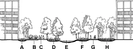
Figure 1.4The narrowest and the most urban corridors are surrounded by high-rise buildings. However, planted swales and basins collect and treat stormwater. A – bioswale; B – use node; C – pedestrian walk; D – infiltration basin; E – stormwater catchment; F – bioswale; G – pedestrian walk; H – bioswale.
Image: Kongjian Yu, 2014.
Figure 1.5This section through a secondary corridor (200–300 feet wide) illustrates the great attention to landform grading required to implement the surface drainage system and create treatment areas where non-point source pollution can be mitigated through filtration, sedimentation and biological processes. A – road; B – bioswale; C – bikeway; D – terrace; E – waterside path; F – infiltration wetland.
Image: Kongjian Yu, 2014.
At Wulijie, the wide corridors are appropriate for high-density development. The patches of habitat are provided at the corridor intersections in the most highly developed areas or as nodes attached to the perimeter corridors. The corridors become narrow as development intensifies, as shown in Figures 1.7 and 1.11.
Both the public landscape and the development parcels have development controls to assure effective implementation. Figure 1.12 shows a small portion of the controlling plan for development. These controls include build-to lines and links to the development requirements including standards for the public landscape. This plan most clearly shows the tertiary corridors separating the development parcels.
Figure 1.6The widest corridors (up to 500 feet wide) feature the best biological diversity, but recreation and stormwater storage and treatment are equally important. The intersections of the widest corridors create larger habitat patches.
Image: Kongjian Yu, 2014.
Figure 1.7 This image shows an intersection between one of the widest corridors and an intermediate one. It is remarkably consistent with the character imagined in the drawing inFigure 1.6.
Photo: Kongjian Yu, 2015.
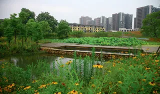
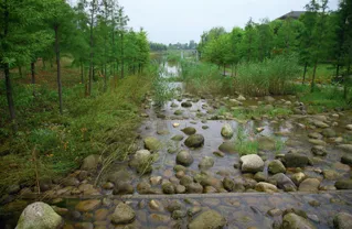
Figure 1.8 This image of one of the widest corridors illustrates that they support significant habitat, as upland species of shrubs and trees are adjacent to extensive wetlands. The presence of such expansive open space within high-density urban development is rare.
Photo: Kongjian Yu, 2015.
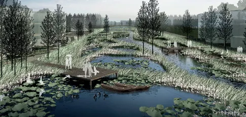
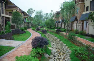
Figure 1.9This is an intermediate corridor at Wulijie. The diversity and beauty of the planting design is inspiring, but this is also a working landscape. In the foreground, a basin captures sediment in the first step of water quality improvement.
Photo: Kongjian Yu, 2015.
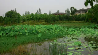
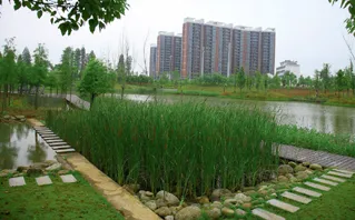
Figure 1.10 This image illustrates that there is great variety in the visual character coupled with diverse treatment strategies within the intermediate wetland corridors.
Photo: Kongjian Yu, 2015.
Figure 1.11 The narrowest corridor is the most urban in character but sufficiently wide to provide space between the buildings for light and privacy. The width still accommodates the landscape infrastructure.
Photo: Kongjian Yu, 2015.
Figure 1.12The controlling plan for a small section of the new town of Wulijie.
Image: Kongjian Yu, 2014.
Material selection, architecture featuring passive and active solar technology, public transportation options and other factors must be added to the consideration of storm water, open space, recreation and habitat in order to build a city with minimum adverse environmental impact. Indeed, a high-speed train station and other features are included in the plans for Wulijie. The first phase of the new town is complete. As other sections are completed and the project matures, we will have a new model of sustainable development to monitor and learn from. The images of the planning documents, conceptual perspectives and, most importantly, the installed landscape shown here indicate that the result fulfils the promise of the artist’s rendering in Figures 1.13 and 1.14.
Figure 1.13The artist’s rendering of the proposed development shows the major ecological corridor in the centre and to the right in this night-time scene. The secondary corridors establish smaller districts, while the narrowest corridors separate the buildings.
Image: Kongjian Yu, 2014.
Figure 1.14 This image shows where the primary and intermediate corridors meet. Consistent with the planning and design intensions, the narrower corridors capture and treat stormwater run-off. During large storms, the narrow corridors conduct floodwater to wider corridors in the network. Boardwalk and other pathways invite...
Table of contents
Cover
Half Title
Title Page
Copyright Page
Table of Contents
List of figures
List of tables
Acknowledgments
1 Water and sustainable urban design
2 Characteristics of wastewater
3 Free water surface constructed wetlands
4 Horizontal subsurface flow treatment wetlands
5 Vertical subsurface flow constructed wetlands
6 Hybrid constructed wetlands
7 Plants in constructed wetlands
8 Riparian wetlands
9 Stormwater management and sustainable development
10 Increasing the sustainability of agriculture
11 Treatment of industrial effluent in constructed wetlands
Appendix A
Appendix B
Appendix C
Index
Frequently asked questions
Yes, you can cancel anytime from the Subscription tab in your account settings on the Perlego website. Your subscription will stay active until the end of your current billing period. Learn how to cancel your subscription
No, books cannot be downloaded as external files, such as PDFs, for use outside of Perlego. However, you can download books within the Perlego app for offline reading on mobile or tablet. Learn how to download books offline
Perlego offers two plans: Essential and Complete
Essential is ideal for learners and professionals who enjoy exploring a wide range of subjects. Access the Essential Library with 800,000+ trusted titles and best-sellers across business, personal growth, and the humanities. Includes unlimited reading time and Standard Read Aloud voice.
Complete: Perfect for advanced learners and researchers needing full, unrestricted access. Unlock 1.4M+ books across hundreds of subjects, including academic and specialized titles. The Complete Plan also includes advanced features like Premium Read Aloud and Research Assistant.
Both plans are available with monthly, semester, or annual billing cycles.
We are an online textbook subscription service, where you can get access to an entire online library for less than the price of a single book per month. With over 1 million books across 990+ topics, we’ve got you covered! Learn about our mission
Look out for the read-aloud symbol on your next book to see if you can listen to it. The read-aloud tool reads text aloud for you, highlighting the text as it is being read. You can pause it, speed it up and slow it down. Learn more about Read Aloud
Yes! You can use the Perlego app on both iOS and Android devices to read anytime, anywhere — even offline. Perfect for commutes or when you’re on the go. Please note we cannot support devices running on iOS 13 and Android 7 or earlier. Learn more about using the app
Yes, you can access Constructed Wetlands and Sustainable Development by Gary Austin,Kongjian Yu in PDF and/or ePUB format, as well as other popular books in Architecture & Urban Planning & Landscaping. We have over one million books available in our catalogue for you to explore.