Urban redevelopment in American cities is neither easy nor quick. It takes a delicate alignment of goals, power, leadership and sustained advocacy on the part of many. Rebuilding the American City highlights 15 urban design and planning projects in the U.S. that have been catalysts for their downtowns—yet were implemented during the tumultuous start of the 21st century. The book presents five paradigms for redevelopment and a range of perspectives on the complexities, successes and challenges inherent to rebuilding American cities today. Rebuilding the American City is essential reading for practitioners and students in urban design, planning, and public policy looking for diverse models of urban transformation to create resilient urban cores.
eBook - ePub
Rebuilding the American City
Design and Strategy for the 21st Century Urban Core
- 250 pages
- English
- ePUB (mobile friendly)
- Available on iOS & Android
eBook - ePub
Rebuilding the American City
Design and Strategy for the 21st Century Urban Core
About this book
Trusted by 375,005 students
Access to over 1.5 million titles for a fair monthly price.
Study more efficiently using our study tools.
Information
Topic
ArchitectureSubtopic
Urban Planning & LandscapingSection 1
The Anchor Institution: Leveraging Stability
Drawing on Anchor Institutions to Catalyze Neighborhood Revitalization

1.1
Buffalo, NY:
Buffalo Niagara Medical Campus
Buffalo, NY
From its origins as a settlement along the shores of Lake Erie in 1789, Buffalo blossomed as a trade route and destination. Strategically located at the western terminus of the Erie Canal, Buffalo saw its population explode as rail replaced waterways. The city became a major railroad hub and a springboard for the country’s westward expansion. In 1900, Buffalo, New York, was the eighth largest city in the United States with a population of 352,000. Until World War II, it could still count itself among the top 10 largest economies in the United States.
Traces of Buffalo’s rich history can be found dotted throughout the downtown core and broader region. Embedded within an elegant radial street and grid plan by Joseph Ellicott are buildings designed by some of the most influential architects of their time. Formative buildings by Louis Sullivan (Guaranty Building), Frank Lloyd Wright (Darwin Martin House), Eliel and Eero Saarinen (Kleinhans Music Hall) and H.H. Richardson (Buffalo Psychiatric Hospital) are a testament to the city’s considerable social and cultural importance.
As with many other industrial centers, however, Buffalo’s economy struggled in the mid-to late 20th century. Much of the manufacturing sector relocated to the south and west portions of the country, in a systematic exodus that led to a precipitous decline in the city’s fortunes. The rich architectural legacy that defined Buffalo’s rise at the turn of the 19th century became increasingly eclipsed by sublime images of its decline in the 20th. Images of the city’s solemn grain silos and abandoned rail station continue to haunt a place that is eager to shed its reputation as a shrinking, cold-weather, postindustrial city. Over the last two decades, by strategically investing in particular areas of the city, rather than trying to address the entire region, Buffalo has nurtured an infrastructure that is rightsized to its economic strengths. The “Queen City” is rapidly shedding its Rust Belt image.
Strategic Planning, Strategic Investments
By the year 2000, Buffalo’s population had dropped nearly by half, from 580,000 in 1950 to 293,000 (Urban Design Project, 2006). With a reduction in population came a wide range of associated maladies: a reduced tax base, strained fiscal resources and an erratic dispersion of people in areas once densely populated and vibrant. The effects of contraction were exacerbated by the fact that the city’s urbanized area continued to grow, diluting important municipal services. While Buffalo has not suffered the extreme population decline that is evidenced in other postindustrial cities such as Detroit, Michigan, or Youngstown, Ohio, a number of downtown neighborhoods have high enough vacancy rates to appear isolated and neglected (Mallach & Brachman, 2013).

Medicine, education, research and entrepreneurship are driving private investment in and around the Buffalo Niagara Medical Campus.
Credit: Douglas Levere/© University at Buffalo, 2013
In 2003, the city created “Downtown Strategic Investment Areas” as part of a Regional Action Plan for downtown, which would become a component of the City’s Comprehensive Plan.1 Five neighborhood clusters were identified as having the most potential for transformation. Each area was characterized by its respective strengths and by the existing community assets that could be leveraged. Among these areas was the Buffalo Niagara Medical Campus. Buffalo’s downtown core is in resurgence today not only because the city has focused development in strategic districts, but also because it has embraced some of the largest growing business sectors today, the medical, academic and scientific industries. In the first decade of the 21st century, the Buffalo Niagara Medical Campus (BNMC) is where the greatest transformation in the city has occurred.
Building a Critical Mass
At the confluence of medicine, education and research—Buffalo’s new economies—the Buffalo Niagara Medical Campus has emerged as a major player in the national healthcare scene. Located less than a mile from the centerpiece of Joseph Ellicott’s radial street plan at Niagara Square, the 120-acre campus is situated between the neighborhoods of Allentown and the Fruit Belt. The western edge of the campus is defined by Main Street, upon which the region’s light rail transit line connects the downtown and waterfront to the University at Buffalo Campus just over six miles (10 kilometers) away.2
The medical campus was established in 2001 to brand and co-locate disparate medical-service institutions together as a single physical place. This strategy capitalized upon the biomedical research, education, business and clinical organizations that were already in proximity to each other but operating independently. The ambition to join together as a consolidated medical campus was the result of increased competition for services, and coincided with a New York State initiative to consolidate healthcare providers and remove redundancy from the healthcare system. Between 2001 and 2014, the BNMC invested over $1 billion in new, shared structures and streetscape design. The initial consortium of five primary institutions has matured during this time into a full-fledged Academic Health Center with over 20 individual institutions. The critical mass has attracted the University at Buffalo’s (UB) School of Medicine and Biomedical Sciences to the downtown campus.3
The Challenges of Planning for Medical Institutions
There is an inherent challenge in planning for medical institutions whose needs change rapidly. Transformations in healthcare delivery and the pressures to meet exceptional quality of care require that institutions constantly evaluate their planning and construction goals. Itemizing the growth needs of a hospital for the short or long term is a difficult endeavor, and if designing a single medical facility is complicated, than developing an expansion plan for a campus of many such facilities is even more demanding. To further complicate matters, in instances where multiple institutions constitute a consortium (such as the BNMC), each member has its own facility master plan. These are often created independent of one another as each organization seeks to leverage its own intrinsic advantages of proximity and place.
There are pitfalls for individual developments that are built in the wrong location, at the wrong time and with a density that diminishes the possibility for future linkages and partnerships. Individual projects planned in isolation can easily siphon away opportunities to enhance the open space networks or other shared amenities between institutions. The patchwork of property ownership also makes connections between institutions difficult, even as the need for “coatless connections” requires coordination. In the case of the BNMC, aligning and reconciling individual plans was an early and necessary endeavor.
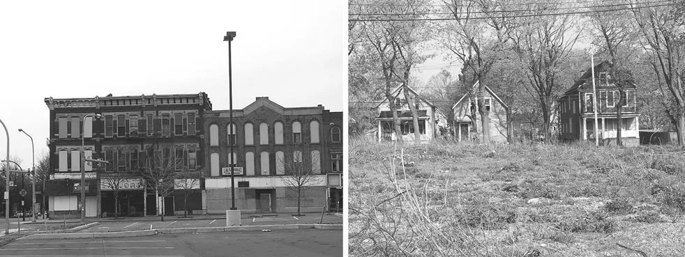
(left) The medical campus lies adjacent to Main Street and Allentown where the historic building fabric suffered from neglect. (right) To the east, the oldest inner-city neighborhood—the Fruit Belt—was losing its identity and cohesion.
An Urban Design Framework
Shortly after its formation in June 2001, the BNMC initiated its first Master Plan. Led by Chan Krieger & Associates (now NBBJ), the master plan proposed a framework for growth that improved the physical environment as it created a collaborative working environment for the emerging partnership. There were many underutilized sites within the geography owned or controlled by the member institutions. The sites had either obsolete facilities or were dedicated to service or surface parking. An inventory of properties within the campus boundary indicated that much of the projected growth could be accommodated within the existing campus footprint without significant land acquisition if the BNMC proceeded wisely, enhancing community partnerships and maximizing development potential on underutilized sites. Density in its core rather than expansion outward would prove to be key to the consortium’s success.
The urban design framework that emerged under the Master Plan established an armature for new development that consolidated each institution’s presence and reinforced a collective identity that would grow over time. The plan identified a single axis in the center of campus that included the most underutilized parcels but had the added benefit of including property from each of the five major institutions. Ellicott Street, the north–south spine, had the most potential to bring the institutions together and alleviate pressures on the seams it shared with the adjoining neighborhoods. The primary urban design concept on campus was a setback along this axis. While initially conceived as a device to structure new development, the setback would become rebranded as a linear park in a later phase of implementation. The park brought together the existing and future institutions along a shared open space. The 2003 Master Plan therefore envisioned a setback along this axis and, in 2006, nARCHITECTS won an Arts Master Plan by proposing to join the space of this setback and the street right-of-way to create a new linear park. The alignment and resulting new park (rebranded as Ellicott Park) brought together the existing and future institutions along a shared open space.
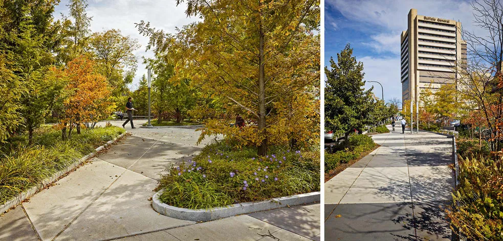
The 2006 Arts Master Plan advanced the initial 2003 BNMC Master Plan by establishing a linear park.
Credit: Frank Oudeman/nARCHITECTS
The linear open space was complemented with a series of east–west running perpendicular connections that tied the adjoining communities together on either side of the campus and anticipated future expansion. While the geography within the 120 acres lacked a unified campus character, the seams it shared with its neighbors suffered even more neglect, with considerable vacancies in existing buildings and numerous vacant lots. Over time, the impression of crime, if not the actual evidence of it, had turned the various institutions inward. The perpendicular organizing principle included an extension of Allen Street in order to connect the campus and Fruit Belt neighborhood on the east to an existing light rail stop on Main Street, to the west of the campus.
The Master Plan suggested that future buildings follow a 20-foot (6-meter) building setback from Ellicott Street’s eastern property line in order to establish a physical presence for future development.4 The armature had the distinct advantage of spanning the length of the campus, helping to align the close proximity of the medical campus to other concentrations of activity to the south. It also meant that the land of the setback impinged upon the property of individual institutions who each valued the land that they owned. Identifying underutilized space within an urban design plan is seldom a dilemma. Acquiring that land for communal use is much more challenging as the real estate is often owned by specific entities who each have their own agendas.
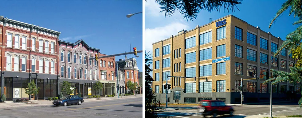
The Master Plan was based on the premise that as the campus grows, so too should the adjoining neighborhoods. Adaptive reuse is underway along Main Street (left) and Goodell Street (right).
Rebuilding the Seams
As employment rises on the BNMC campus, the rehabilitation of historic properties around it is attracting retail activity along Main Street in a portion of the corridor that has languished from decades of disinvestment. To the east of the campus, residential infill construction led by St. John Baptist Church is marking the first stage of larger redevelopment initiatives to come. Since 2003, the faith-based institution has redeveloped over 125 single- and multi-family homes on vacant sites within the Fruit Belt’s fine-grained street grid.
The City of Buffalo has more than 10,000 vacant structures within its municipal boundaries. By redeveloping specific infill sites surrounding its church, St. John is providing housing options for its residents who are located in McCarley Gardens, a low-density affordable housing project of 150 units lying in the shadow of the medical institutions. In addition to providing a spiritual role, the church here provides leadership in a variety of outreach and com...
Table of contents
- Cover
- Half Title
- Title Page
- Copyright Page
- Dedication
- Table of Contents
- Acknowledgments
- Foreword
- Introduction
- Section 1 The Anchor Institution: Leveraging Stability
- Section 2 The Urban River: Leveraging a Natural Resource
- Section 3 The Existing Urban Fabric: Leveraging Context
- Section 4 The Urban Park System: Leveraging Underutilized Land and Infrastructure
- Section 5 The Downtown District: Leveraging Proximities and Transit
- Appendix: Methodology: Criteria of Rebuilding
- Index
Frequently asked questions
Yes, you can cancel anytime from the Subscription tab in your account settings on the Perlego website. Your subscription will stay active until the end of your current billing period. Learn how to cancel your subscription
No, books cannot be downloaded as external files, such as PDFs, for use outside of Perlego. However, you can download books within the Perlego app for offline reading on mobile or tablet. Learn how to download books offline
Perlego offers two plans: Essential and Complete
- Essential is ideal for learners and professionals who enjoy exploring a wide range of subjects. Access the Essential Library with 800,000+ trusted titles and best-sellers across business, personal growth, and the humanities. Includes unlimited reading time and Standard Read Aloud voice.
- Complete: Perfect for advanced learners and researchers needing full, unrestricted access. Unlock 1.5M+ books across hundreds of subjects, including academic and specialized titles. The Complete Plan also includes advanced features like Premium Read Aloud and Research Assistant.
We are an online textbook subscription service, where you can get access to an entire online library for less than the price of a single book per month. With over 1.5 million books across 990+ topics, we’ve got you covered! Learn about our mission
Look out for the read-aloud symbol on your next book to see if you can listen to it. The read-aloud tool reads text aloud for you, highlighting the text as it is being read. You can pause it, speed it up and slow it down. Learn more about Read Aloud
Yes! You can use the Perlego app on both iOS and Android devices to read anytime, anywhere — even offline. Perfect for commutes or when you’re on the go.
Please note we cannot support devices running on iOS 13 and Android 7 or earlier. Learn more about using the app
Please note we cannot support devices running on iOS 13 and Android 7 or earlier. Learn more about using the app
Yes, you can access Rebuilding the American City by David Gamble,Patty Heyda in PDF and/or ePUB format, as well as other popular books in Architecture & Urban Planning & Landscaping. We have over 1.5 million books available in our catalogue for you to explore.