![]()
1 Introduction
Climate adaptation is a timely yet complex topic. It does not fit squarely into any one disciplinary realm, especially given the range of strategies, tools, and techniques that must be used to further our understanding of weather-related hazards and the impacts on people and places. Assessing vulnerability and risk, developing strategies to mitigate the potential impacts of natural hazards, and related policy and governance frameworks are examples that demonstrate the complex, interdisciplinary nature of the challenges that planning practitioners and policy-makers commonly face. By examining specific themes and problems, this book provides users with an understanding of the meaningful cross-cutting themes and connections and how the combination of geospatial tools and techniques can be used to plan for mitigation of greenhouse gas emissions and adaptation to climate impacts. However, a discussion of tools and techniques devoid of context and concepts is problematic. As such, the book sets out to provide relevant context and concepts for an intended broad audience of scholars, practitioners, and students.
Global Warming and Climate Change
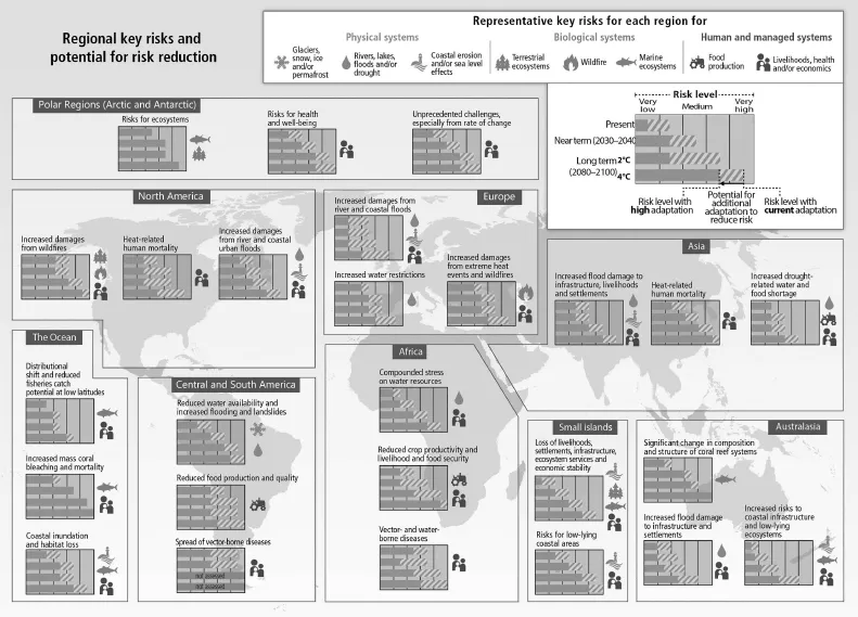
Global warming is the term used to describe an increase in average global temperatures (National Aeronautical and Space Agency [NASA], 2016). The term is also commonly used to indicate a relationship between the rise in global temperatures and the release of excessive amounts of carbon dioxide, methane, and other greenhouse gases. The temperature increase documented over the past century is largely attributed to the buildup of carbon dioxide from anthropogenic emissions and land clearing and is projected to continue affecting the global climate (Figure 1.1). Scientists prefer the term climate change as a more accurate representation of the multiple processes associated with the increases in global temperatures.
As a scientific concept, climate change was first introduced in 1975 in a paper by the U.S. geologist Wallace Broecker and later adopted by the National Academy of Sciences in the first major study on carbon dioxide and climate published in 1979 (NASA, 2016). Established in 1989, the United States Global Change Research Program adopted the term global change, with climate research being one of its research pillars. Global change and global environmental change are other terms used in the scientific literature, but lesser known to the general public.
Figure 1.1 Risks by region
Overcoming the challenges posed by climate change will require understanding and action on a personal level and engagement of multiple sectors and governments across the globe. Successful mitigation of greenhouse gas emissions and effective climate adaptation planning depend on a multitude of actions and initiatives passed at global, national, regional, state, and local levels. In December 2015, 195 nations, Parties to the Paris Agreement, pledged their support for measures that can cap greenhouse gas (GHG) emissions and, more importantly, set the agenda for large-scale strategic planning in climate mitigation and adaptation. The Paris Climate Conference is officially known as the 21st Conference of the Parties (COP21). The proposed strategies garnered the attention of world leaders, policy-makers at the highest level of authority, regional and city governments, and businesses and citizens alike. Kim, Smith, Mack, Cook, Furlow, and Njinga Cote (2016) describe a paradigm shift in national climate adaptation planning from “short-term, project-level interventions” into strategic considerations related to longer-term development goals.
In addition to actions at the global, national, regional, and local scale, climate adaptation is contingent upon myriad actions taken by individuals in their daily lives, including mode of transportation choices, home improvements, relocation decisions, and personal involvement in local climate initiatives. The ability to visualize the spatial distribution of hazards, and analyze interrelatedness between physical, social, economic, and environmental factors, is also fundamental to planners, policy-makers, and other professionals who work on climate mitigation and adaptation issues.
Climate Change Mitigation and Adaptation
Climate change commitments fall into two fundamental response strategies: climate mitigation and adaptation. Climate mitigation is defined in the Intergovernmental Panel on Climate Change (IPCC) Fourth Assessment Report as “anthropogenic intervention to reduce the sources or enhance the sinks of greenhouse gases” (IPCC, 2007). Climate mitigationrefers to actions that reduce the human contribution to the planetary greenhouse effect (Melillo, Richmond & Yohe, 2014). According to the United Nations Environment Programme (UNEP), mitigation actions can range from complex and high-tech projects (such as subway systems) to other simpler initiatives such as walkways (UNEP, 2017).
According to Climate-Eval Community of Practice (2015, p. 3), climate change adaptation (CCA) focuses on anticipating the risks and adverse impacts of a changing climate, taking appropriate action to prevent or minimize the damage, and seizing on potential opportunities that may arise. Climate adaptation also promotes the ability to cope with short-term climate impacts from extreme events and strategies for long-term response, including minimizing the threat of potential population displacement.
Climate change adaptation pathways may include fashioning programs, projects, and policies that try to minimize the effects of climate change. These pathways and interventions can take the form of disaster risk reduction and promotion of community resilience and capacities to respond to, cope with, and prepare communities for climate variability (Climate-Eval Community of Practice, 2015, p. 3). As such, it is important that this book provides in-depth coverage of rapid-onset and slow-onset natural hazards. Rapid-onset hazards develop with little warning and strike rapidly (e.g., volcanic eruptions, flash floods, landslides, severe thunderstorms, lightning, and wildfires) while slow-onset hazards take years to develop (e.g., droughts and sea level rise).
Climate change is intensifying the impacts of natural disasters given forecasts for more frequent hot days and nights over most land areas, more heat waves and droughts, heavier precipitation and rainfall events, and increases in intense tropical cyclones. Global warming is also expected to have an effect on cities along the banks of rivers. River flooding risk is projected to increase due to a higher prevalence and intensity of storms, and the economic value of urban infrastructure is expected to increase over time (Hirabayashi et al., 2013; Winsemius et al., 2016). Hirabayashi et al. (2013) reported notable increases in flood frequency in Southeast Asia, Peninsular India, eastern Africa, and the northern half of the Andes. From 1971 to 2010 ocean temperatures increased by 0.11°C per decade (IPCC, 2014), and the mean sea level rose by 0.19 meter from 1901 to 2010 (IPCC, 2014). In addition, the acidity of oceans (measured by pH) increased by 26% during the same period (IPCC, 2014). Coastal zones are particularly susceptible to erosion, accretion of sediments, saltwater intrusion, and sea level rise. The increased frequency and severity of storms is expected to exacerbate these processes (Masria, Iskander & Negm, 2015).
The Role of Spatial Planning and Geospatial Technologies
Climate mitigation and adaptation planning is as much policy as it is politics and science. Its success greatly depends on adequate data support. Planning for climate adaptation is unlike any other planning process given the long-term horizons, projections, uncertainty, and coupling of natural systems with human interactions. Activities, events, and phenomena all occur in a geographic context; therefore, all data are explicitly or implicitly spatial data. Spatial data are embodied in digital files, web portals, locational services, spatial data infrastructures, and real-time data capture and management. Spatial data play a significant role in storing geographic knowledge and analyzing trends and patterns of human activities. Spatial data applications range from a simple display of geographic features on a map to complex multilayered/multidimensional analyses of health, crime, hazards, real estate, transportation, business operations, social media, and more. Furthermore, many decisions are driven by their geographical contexts, with climate adaptation as a prime example.
Successful implementation of climate mitigation and adaptation policies will depend upon a robust understanding of spatially explicit information, rigorous vulnerability analysis, competent scenario planning, and visioning of alternatives and solutions. Virtually any adaptation decision begins with available scientific data, identification of knowledge gaps, and a quest for data resources sharing and capacity building. Geospatial technologies that combine the tools of a geographic information system (GIS), remote sensing, and global positioning systems (GPS) provide some of the widely available tools to build a strategic knowledge that reflects the latest advances in the scientific understanding of climate and its impacts and has the analytical leverage to inform policy decisions. Geospatial technologies are well suited to vulnerability assessment and, at the most fundamental level, to urban systems spatial modeling.
Increasingly, integrated spatial assessments of physical and social vulnerability to climate-related hazards use GIS as a visualization and analytical platform to link meteorological information with other environmental and socioeconomic data (Wilhelmi & Morss, 2013). Demographic data are an essential source of information used by planners and policy-makers to assess social vulnerability. Socioeconomic variables (e.g., population density, housing and homeownership, income, educational attainment, gender, age, and race) are often overlaid with other datasets for all phases of the disaster management cycle. Assessing vulnerability and risk, developing strategies to mitigate the potential impacts of natural hazards, and formulating policy and governance frameworks are examples that demonstrate the complex, interdisciplinary nature of the challenges that planning practitioners and policy-makers commonly face.
Engaging the “Whole Community”
Adaptation at the community level is largely dependent on buy-in and adoption of strategies and tools. Climate adaptation by nature connotes a proactive approach and inclusion of a broad range of stakeholders. Successful climate adaptation, therefore, requires the engagement of what the United States Federal Emergency Management Agency (FEMA) describes as the “whole community” approach. In the context of hazard management, a broad understanding of community risks, needs, resources, and capabilities must be captured. That approach “attempts to engage the full capacity of the private and nonprofit sectors including businesses, faith-based and disability organizations, and the general public, in conjunction with the participation of local, tribal, state, territorial, and Federal governmental partners” (FEMA, 2011).
Who should be involved in climate adaptation practice and research from various sectors remains a work in progress, but we can borrow from scholars such as Buanes, Jentoft, Maurstad, Soreng, and Karlsen (2005), Schwab (2010), FEMA (2011), and Smith (2012) with regard to some non-traditional stakeholders that need to be engaged in climate adaptation planning. These stakeholders include advocacy groups, airports, colleges, universities, chambers of commerce, financial institutions, insurance, media, public transportation systems, and utility providers. Several factors need to be considered, including engagement of community residents and planning and policy professionals for tasks such as vulnerability and assets assessment and scenario-building. As noted by Esnard (2012, p. 306), planners have increasingly filled their visualization toolkit to:
(8) enhance and inform multiple planner roles and tasks (e.g., plan maker, regulator, mediator, advocate, technical analyst); (ii) facilitate participatory and communicative planning processes; (iii) integrate and interpret data from disparate sources and in a variety of formats; and (iv) facilitate iterative processes in the analysis and recursive exploration of data.
Beyond planners, a broader range of private stakeholders and local interests must be involved, although participating groups are sure to vary by country and across economic sectors. In Norway, for example, the list of stakeholder participation in coastal zone planning is categorized as: (i) private stakeholders including fishermen and tourist operators; (ii) public stakeholders including government officials; and (iii) local interests such as recreation organizations, cottage owners, and developers and landowners (Buanes, Jentoft, Maurstad, Soreng & Karlsen, 2005).
Overview of Chapters
By examining specific themes and problems, this book provides users with an understanding of the meaningful thematic and conceptual linkages across disciplines and how the combination of geospatial tools and techniques can be used to mitigate climate impacts or inform climate adaptation strategies. In addition to the introduction (Chapter 1), the remaining 14 chapters are organized into four sections. Each chapter is grounded in the literature and uses examples and case studies from a diverse international group of scholars and entities in the public and private sectors. The focus is on reinforcement of geospatial applications and tools that can be used to explore problems and design climate-relevant solutions at multiple scales.
Part I, Climate Change and Climate Adaptation Planning: Context and Concepts, includes Chapters 2, 3, and 4. Chapter 2 briefly discusses how climate change issues have gained political saliency and highlights some of the efforts of the international community toward legally binding commitments to reduce greenhouse gases. The chapter also features global, regional, and local initiatives and commitments toward “low-carbon cities.” Chapter 3 examines ...