![]()
1
WHY MICROWAVES?
Opportunities multiply as they are seized.
— Sun Tzu, The Art of War.
The fundamental reason for using microwaves for remote sensing is that they are different. That sounds a rather trivial statement, but is true nonetheless. By using the microwave region of the electromagnetic (EM) spectrum we gain capabilities that complement remote sensing methods used in other spectral regions — microwave interactions, in general, are governed by different physical parameters to those that effect other forms of EM radiation. For example, the amount of microwave energy of a particular wavelength scattered off a green leaf is proportional to its size, shape and water content, rather than the amount of chlorophyll (or “greenness”).
Microwaves have further advantages: some can penetrate clouds and can even get through the top layer of dry soils or sand (by as much as a few metres in some circumstances). And since thermal emission is observed in passive imagers, and you provide your own illumination with active imagers, the measurements can be made at any time without relying on background sources such as the Sun. A further advantage for atmospheric remote sensing over, say, infrared techniques is that microwave wavelengths can be chosen such that ice clouds and other particulates (such as aerosols) have negligible effects on the signal.
Of course, there are also some disadvantages. The long wavelengths mean that large (about a metre or more) antennas are required even to achieve the kinds of spatial resolutions appropriate for regional-scale studies (many kilometres). And active microwave systems, such as Synthetic Aperture Radar (SAR) instruments, tend to be the heaviest, largest, most power consuming, and most data prolific instruments that are ever likely to fly on Earth observing satellites (and are therefore the most unpopular for all non-SAR devotees!). In addition, as will become apparent later in these notes, the interpretation of data from such instruments is rarely simple.
The term “microwave” is used throughout this text as a generic term to include centimetre, millimetre and submillimetre wavelength regions of the electromagnetic spectrum. Within the context of imaging radar this definition will also be stretched a little into the radio wave region when we additionally consider wavelengths up to a metre or longer.
1.1 Overview of Microwave Systems
On a rather general level, we may distinguish two types of microwave remote sensing instrument: active and passive.
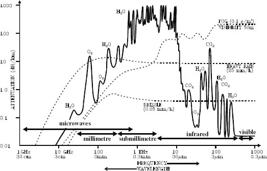
Passive sensors, or radiometers, measure the microwave energy that is radiated (by thermal emission) or reflected (from the sun or other radiating objects) by the Earth’s surface or atmosphere. A careful selection of observing frequency will allow measurements of the atmosphere, the ground, ice or rain. Figure 1.1 shows the atmospheric attenuation over the range of the electromagnetic spectrum. Those radiometers that are used to measure emission from the atmosphere are termed microwave sounders.
Active sensors, such as radar systems, generate their own illumination by transmitting pulses of microwave radiation and then using a specialised receiver system to measure the reflected (or more precisely, scattered) signal from the area of interest. They primarily (but not exclusively) use wavelengths greater than 3cm (<10GHz) where the atmosphere becomes virtually transparent.
1.1.1 Information from Passive Microwave Imagers
The microwave emission from objects are primarily dependent upon the objects physical temperature and its dielectric properties (i.e. their frequency dependent radiative/absorptive properties). We will see later that it is practical to define the measured microwave intensities in terms of temperature-like properties.
The dielectric properties are related to the physical make-up of the object: i.e. the materials it is made from. For most practical applications of passive imagers (for land observation and sea ice) the most significant factors effecting the measured intensities are temperature, salinity and liquid water content. The surface roughness also has an influence on the directivity of the emission.
1.1.2 Information from Passive Microwave Sounders
A unique feature of microwave spectroscopy for radiometry is the ability to design instrumentation which simultaneously gives the best possible spectral resolution and sensitivity of thermal emission measurements at long wavelengths. Measurements can be made of a number of physical parameters and molecular concentrations required for monitoring the global atmospheric system and for testing and developing atmospheric models; e.g. temperature, pressure, liquid water, rainfall, and a collection of molecular concentrations, including water vapour and ozone.
FIGURE 1.1 The attenuation of the atmosphere for a nominal clear atmosphere, with additional attenuation shown for fog, heavy rain and drizzle. Notice that the regions used most often for terrestrial remote sensing are in the “windows” (visible and microwave) while atmospheric sounding is carried out in the “walls” (millimetre to infrared). (After Preissner 1978, cited in Peckham 1991).
1.1.3 Information from Active Microwave Instruments
The optimism that still surrounds SAR imaging systems stems from both its unique properties (which are quite distinct from conventional optical and IR imagers) and its staggering potential to measure physical properties of ground features at high resolution. The properties of microwaves also allow imaging through clouds (ideal for observing regions perpetually covered in cloud, such as the surface of Venus and the humid tropics on Earth), and because SAR is an active system, both day and night imaging is possible, which offers the opportunity to obtain continuous coverage by Earth orbiting satellites.
In addition, the singular nature in which microwaves interact with surface features means that information obtained can be indicative of moisture content, salinity and physical characteristics (shape, size, orientation) — not just reflectivity. While it is generally convenient to consider a radar image as a representation of the reflecting properties (backscatter) of the terrain at radar wavelengths at each position within the image, we shall see in later chapters that this is perhaps a rather too simplistic way of thinking about such images.
Of course, every silver lining has a cloud: the digital processing and interpretation of such images are rarely straightforward. In terms of visual interpretation the most obvious problems are speckle and geometry. The effect of speckle (which is dealt with in Chapter 10) can be all but removed at the expense of spatial resolution, but the unnatural geometry is an inherent effect resulting from the imaging process of radar which maps objects as a function of their slant-range from the instrument rather than look-angle (as in optical systems). This can also be partially compensated for by geocoding or interferometry, or by other rectification methods, but areas of ambiguity always remain.
A further problem is our limited knowledge of how microwaves interact with surfaces and although there are various theoretical models at this time there is by no means a definitive way to characterise the interactive processes.
There are also headaches for the engineers and system managers. A typical SAR system weighs in at about 400kg, requires kilo-Watts of power (it is an active system remember), uses an antenna about 10 × 1 m and transmits data at a rate of many hundreds (if not thousands) of Mbps. So, for Earth observation it is the largest, heaviest, most power consuming and most data prolific instrument that could be put on a satellite. By way of illustration, the Microwave Limb Sounder on the Upper Atmosphere Research Satellite was only half as massive as the Active Microwave Instrument on the ERS satellites, used a tenth of the power, had an antenna one fifth of the size and transmitted less data per second by a factor of 100,000.
Despite these drawbacks, synthetic aperture radar (SAR) has developed into a highly successful imaging tool since its origins in the 1950s. The first SARs were carried on aircraft, but in 1978 NASA launched a SAR onboard the Seasat satellite. Although it failed after only 6 weeks the data was still being studied over ten years later.
Synthetic aperture radar has arguably been the most exciting and progressive field of remote sensing over the last decade, and is likely to continue to be so well into the new century1. Already ESA (the European Space Agency) has had successful missions with ERS-1 & 2, Japan’s space agency (JAXA) with JERS-1, and Canada with Radarsat, all of them carrying SAR instruments. These have been followed by ESA’s Envisat in 2002, and (hopefully by the time you read this) JAXA’s ALOS and Canada’s Radarsat 2. Additionally, the first commercially-oriented (rather than research oriented) radar satellite, TerraSAR-X is also shortly due for launch.
NASA meanwhile has continued its program of short term SAR missions on board the Space Shuttle, including the impressive 11-day Shuttle Radar Topography Mission in February 2000, as well as many short missions using their airborne AIRSAR instrument. Canada, The Netherlands, Denmark, France and Germany also continue with specific airborne SAR campaigns, and Intermap Technologies now fly the first truly operational commercial airborne SAR mapping system.
Elsewhere in the solar system, following the success of the SAR carried by the Magellan probe to Venus in 1990, the Marsis (Mars Advanced Radar for Subsurface and Ionosphere Sounding) instrument has been sent to Mars on the Mars Express Mission, and the Cassini Radar has been sent to Saturn and its largest moon, Titan. At the time of writing the Cassini radar is days away from its closest fly-by of Titan, and Marsis has been given the green light to deploy its antenna after a long delay due to unanticipated problems with the deployment mechanism.
1.1.4 How Can This Information be Used?
There are countless applications for which microwave remote sensing has proved capable of providing information comparable with, and sometimes beyond, that obtained with optical/IR sensors. Beyond these successes, there are also a few applications that are unique to microwave systems (e.g. those involving interferometry).
Here is a selection of some of the applications that have utilised microwave remote sensing: Planning shipping routes through the ice fields of the Arctic; observing deforestation in the tropical forests of Amazonia and S.E. Asia; measuring soil moisture variations in the semi-arid areas of the Sahel in Niger; monitoring ship movements and oil spills in seas and oceans; measuring atmospheric temperature and concentrations of ozone and water vapour in the upper atmosphere; making estimates of biomass in temperate forest regions; determination of regions of surface frost and thaw in Siberia; daily measurements of global wind speed and direction over the oceans; long term monitoring of the Antarctic ice shelf; making estimates of snow melt and run-off; inventory mapping of crop types in agricultural areas; mapping of ground movements (after earthquakes or subsidence) to within a few centimetres; mapping of glacial movements and estimates of velocity vectors; detection of ancient roads and river beds beneath metres of Saharan sand; acquisition of near-global topography; estimation of forest canopy heights.
The list continues to grow…
![]()
2
A BRIEF HISTORY OF MICROWAVES
We all know what light is; but it is not easy to tell what it is.
— Dr. Samuel Johnson (1776)
The labours of men of genius, however erroneously directed, scarcely ever fail in ultimately turning to the solid advantage of mankind.
— Mary Shelley, Frankenstein, Vol.I.
The development and exploitation of microwaves helped to shape the world as we know it today. Radio and television, mobile communication, microwave ovens and fanciful death rays all share a common heritage with microwave radiometry and radar systems. Experiments with microwaves led to one of the greatest advances in theoretical physics and laid the foundation of special relativity. The development of radar was probably the single most important contribution to the Allies winning World War II. And half a century of passive microwave measurements has increased our understanding of the solar system and changed our concepts of the size and history of the entire universe.
I begin this history of microwaves over 200 years ago, to a time when electricity, magnetism and light were three distinct phenomena, each wondrous in their own right, but entirely unconnected in the minds of the scientist of the day. Of course, this is a biased history written to set the scene for later chapters and form a basis for explaining the science, rather than intended as a scholarly historical study.
2.1 In the beginning…
There is a persistent mythology within the remote sensing community that the history of remote sensing is rooted in the development of photography in the 19th century. While it may be true that the great, great grandfather of Spot panchromatic imagery may be Nadar’s balloon-borne photograph of Paris, and this in turn relied on the development of photography by fellows such as Niepce and Fox Talbot, it is not true for all forms of remote sensing in operation today. The history of microwave remote sensing shares so little with the history of optical remote sensing, that had photography never been invented, microwave remote sensing would have progressed in much the same way as it did2. This lack of recognition of the distinct ...