![]()
p.1
PART I
The context
![]()
p.3
1
THE MEDITERRANEAN CONTEXT OF EARLY CHRISTIANITY
Philip F. Esler
Introduction
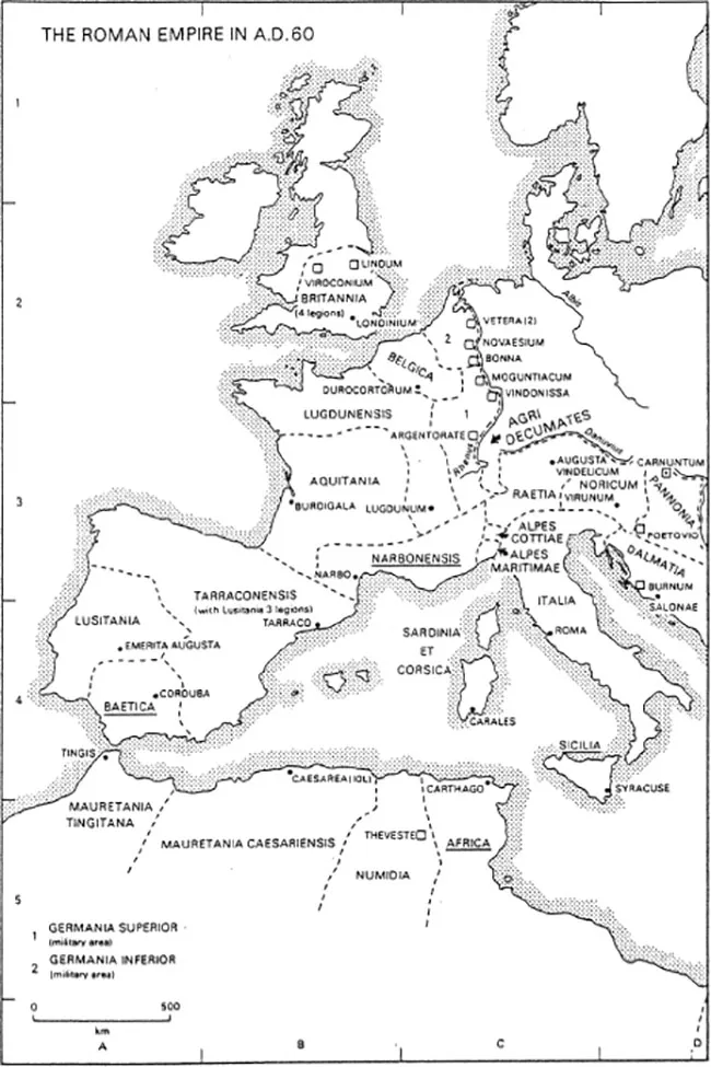
During its first four centuries, from 30 to 430 CE, the phenomenon we now designate as Christianity1 was closely connected with the Mediterranean region, which also constituted the original heartland of the Roman Empire (see Figure 1.1). Vital Christian areas, such as Palestine, Syria, Egypt, Asia Minor, Greece, Italy, North Africa, Gallia Narbonensis and Spain were all washed by the Mediterranean Sea. Parts of the empire further afield, like Cappadocia, Pontus and Bithynia, and even Gaul and Britain had been deeply affected by Mediterranean influences, either by their close proximity to the places just mentioned, or by the ubiquitous practices of Roman provincial administration, or both. There were Christians developing notable traditions somewhat away from the Mediterranean and outside the Roman empire, in places like Armenia and Ethiopia, or even further afield, in India, but they were a small minority of the total Christian population. In any event, even they had been shaped by the missionaries from the Mediterranean countries who had evangelised them.
This context for early Christianity inevitably prompts three fundamental questions: first, in what sense are we able to speak of a Mediterranean region in the first five centuries of our era – that is, was it distinctive and, if so, how? Second, what effect did the ensemble of natural and human features constituting this region have on the new religious movement struggling to be born and grow in its midst? And, third, what impact did Christianity have in turn on its Mediterranean context? Posing the matter like this involves acknowledging the validity of the insight from the sociology of knowledge that there is a dialectic relationship between social settings and the religious institutions and ideas which arise within them, with the settings contributing to the creation of the institutions and ideas while they in turn have an impact on their social settings (Berger 1969: 41, 47; Esler 1994: 10). My aim in this chapter is to set out the broad outlines of an answer to the first of these questions, with occasional reference to the second and third, which constitute a central interest in the essays in this work.
Although my focus will be on geographic, socio-economic and broad cultural questions, other contributors in the first broad section of this volume will deal with other aspects of the ancient Mediterranean context of Christianity, such as the political dominance of Rome, or (from 330 CE) Rome and Constantinople together (Jill Harries in Chapter 2), Graeco-Roman philosophy and religion (Luther Martin in Chapter 3) and Judaism (James Aitken in Chapter 4).
p.4
p.6
The Mediterranean as a physically distinctive region
Topography and climate
‘The Mediterranean is a great gulf of the Atlantic cutting back into the land mass of the Eastern Hemisphere’ (Semple 1932: 4). It carries the ocean 2,330 miles from the straights of Gibraltar to Lebanon, thus in effect giving Asia an Atlantic seaboard. It is enclosed by three continents – to the north, south and east. The northern, or European, coastline, measuring some 13,000 kilometres, is deeply dissected by peninsulas and islands, lying behind which is a fertile hinterland, these two features together providing the basis for the development of maritime trade. The southern, or African, coastline, only 5,000 kilometres long, is barely dissected at all by natural features and has situated behind it lands which are frequently arid, with Egypt, watered by the Nile, being the notable exception. The eastern, or Asiatic, coastline is some 6,000 kilometres long, with much of this due to the deeply indented coastline of Asia Minor. Historically, the Asian part continually mediated between the great civilisations of the east, in the Tigris and Euphrates valleys and even India, and those in the west.
In geological terms, the Mediterranean Sea is relatively young, occupying the areas of depression interposed between the belts of young folded mountains stretching across north-west Africa, southern Europe (especially the peninsulas of Spain, Italy and Greece) and the Asian ranges of the Caucasus and the Taurus. Throughout the region are found narrow coastal plains, while further inland deep valleys separate the folds of young mountains, or intersperse the old plateaus that survived the recent burst of mountain building. Extensive flat areas suitable for tillage are uncommon (Semple 1932: 4–34).
At a general level, similar climatic conditions occur across the Mediterranean lands. The characteristic pattern is that of winter rains and summer droughts. During summer, when the sun’s rays are vertical at the equator, the Mediterranean is subjected to hot and dry northeast trade winds, which supplant the rain-bearing westerly winds of winter and a heat belt moves north from Saharan Africa. In winter the reverse occurs, and the westerlies sweep in across the sea dropping their precipitation, especially when they meet obstacles such as the mountains of Lebanon and Palestine. In many areas, the summer drought is hard on vegetation, and irrigation can be required to maintain plant growth (Semple 1932: 83–101).
Yet the region produces staple cereals (which are generally sown in autumn around the onset of the rains and harvested in early summer), vegetables and fruits (including figs and grapes) and provides reasonable pasturage for small animals, especially sheep and goats, but is not so good for cattle. Most characteristic of the Mediterranean is the ubiquitous olive, whose deep roots allow it to survive the summer drought and produce the oil that in the ancient period was eaten, burnt to provide illumination and used for anointing the skin. The olive takes several years to produce its first fruit and is a reminder of the sedentary nature of Mediterranean life (Finley 1985: 31).
The steady northeast trade winds, which the Greeks called ‘Etesian’, appear in late May and begin to fade in mid-September. For the ancients this was the only safe season for sailing in the Mediterranean. The cyclonic storms typical of winter made navigation hazardous. Hesiod advised his readers ‘to avoid the winter sea when the winds war loud’ (Works and Days 619–25). Merchant vessels operated between 10 March and 10 November, but the safe period was from May to September (Semple 1932: 579–81).
Yet these characteristics common to the region can be deceptive. In 2000, when the original edition of this book was in production, Peregrine Hordern and Nicholas Purcell published a major work entitled The Corrupting Sea: A Study of Mediterranean History. While trying to provide a version of Fernand Braudel’s 1949 magnum opus (La Méditerranée et le Monde Méditerranéen a l’époque de Philippe II) appropriate for the ancient Mediterranean and seeking to link ecological, social and political dimensions of the region, Hordern and Purcell above all stressed that it was best understood as an assemblage of a large number of micro-regions that were a response in part to the fact that there was a large measure of climatic variability across the region. This meant that the human population exploited its fragmented landscape and variable climate in a wide variety of different ways. One result of this was that crop failure or another catastrophe in one micro-region might be balanced by a successful harvest in other places, with the sea allowing movement of food from an area of surplus to an area of deficit. Thus the picture was one of fragmentation yet also connectivity enabled by the relative ease of seaborne trade.
p.7
Ancient Greek and Roman views on the Mediterranean as a distinct region
The fact that modern people are accustomed to thinking of the Mediterranean as a distinctive region for a variety of reasons, such as its geomorphic structure, climate, culture and vegetation – especially in contrast to Northern Europe – does not necessarily mean that its ancient inhabitants had a similar understanding. Nevertheless, the ancient Mediterranean did have a regional identity and its inhabitants recognised this.
The Greeks and Romans broadly divided the area surrounding the Mediterranean Sea into three continents of Europe, Asia and Africa (which they called Libya: Herodotus, 4.42; Strabo, Book 1). Herodotus (writing c. 450 BCE) shrewdly pointed out that Europe is as long as the other two put together (Histories 4.42).2 Like the rest of the ancient world, Herodotus was richly aware of the huge variety of locales, peoples, languages and customs, represented around and inland from its shores. In his Histories he inaugurated the focused study of particular peoples in their homelands, with his accounts of the Egyptians in Book 2 (35–99) and the Scythians in Book 4 (2–36, 46–82) and was followed by a large number of Greek and Roman authors (Almagor and Skinner 2013). Yet in spite of this diversity, the sea itself permitted reasonably easy communication between all of these areas and groups. A remarkably useful discovery such as a phonetic alphabet, deployed soon after its discovery by Semitic peoples such as Phoenicians and Israelites, was soon adopted by the Greeks with whom the latter traded. Technological and artistic developments, religious cults, philosophic ideas and literary genres quickly spread across the region. Greek and later Latin became widely used lingua francas. ‘Ceaseless intercourse back and forth along “the wet ways” bound together the Mediterranean peoples into one great community life’ (Semple 1932: 11). In due course, the Mediterranean would become a vital highway for the spread and institutionalisation of the Christian message (see Chapter 14 of this work).
The ancient Greeks and Romans recognised this sense of regionality. Plato’s Socrates said of those who lived between the Phasis river (in the east) and the Pillars of Heracles (that is, the straits of Gibraltar, in the west) that ‘living around the sea we are like ants or frogs around a pond’ (Phaedo 109B). The Romans called the region the orbis terrarum, the circle of lands, a notion also invoked by an anonymous Greek lyric poet who wrote of ‘the sea-bound circle of the whole dry land’ (Greek Anthology 9, Epigram 672; Paton 1915: 375). Greeks and Romans referred to the Mediterranean as ‘our sea’ (mare nostrum), ‘this sea’ and, simply, ‘the sea’.
Ancient Mediterranean map-making
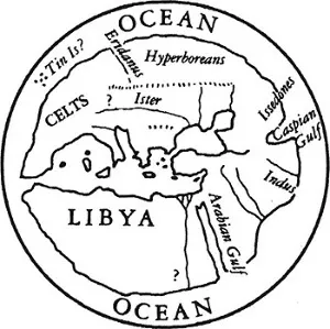
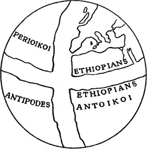
This sense of regionality emerged in ancient attempts to map the world. Older understandings of the cosmos assumed a flat earth, circular in shape and often surrounded by ocean. The Mesopotamian version of this model (which is well represented in the Old Testament) consisted of a flat triple-decker universe, divided into heaven, earth and underworld. Herodotus (writing c. 450 BCE) scoffed at map-makers who drew the earth in perfectly circular fashion, with Oceanus running round the circumference, and with Europe and Asia of roughly equal size (Histories 4.36). He may well have had the maps of Anaximander and Hecataeus, both of Miletus, in his sights (Kirk and Raven 1971: 104). Figure 1.2 is a reasonable modern reconstruction of what such a map might have looked like.3 Such attempts naturally situated ‘our sea’ near the centre of the world.
p.8
By the beginning of the first century CE, however, these cosmologies had largely been replaced in educated Greek and Roman circles by the realisation that the earth was a sphere, not a disk. As early as the second half of the sixth century BCE, Pythagoras and Parmenides of Elea had proposed a spherical earth (Dilke 1985: 25). Aristotle (384–322 BCE) offered proofs for the earth’s sphericity, such as the earth throwing a round shadow on the moon at eclipses (Thomson 1948: 118; Aristotle, de Caelo 297b) and Eratosthenes (c. 275–194 BCE) actually achieved a remarkably accurate measurement of its circumference of around 25,000 miles (Thomson 1948: 159–61).
The inhabited quadrant of the globe (which the Greeks called the oikoumene) was thought to stretch roughly from the straits of Gibraltar in the west to India and China in the east. While residing in Rome in about 168 BCE, Crates of Pergamum designed an orb which set out the position of the oikoumene in relation to other (imagined) parts of the globe (Strabo 2.5.10; Dilke 36), as conjectured in Figure 1.3.
p.9