Introduction
The science of Geology is concerned with the Earth and the rocks of which it is composed, the processes by which they were formed during geological time, and the modelling of the Earth’s surface in the past and at the present day. The Earth is not a static body but is constantly subject to changes both at its surface and at deeper levels.
Surface changes can be observed by engineers and geologists alike; among them erosion is a dominant process which in time destroys coastal cliffs, reduces the height of continents, and transports the material so removed either to the sea or to inland basins of deposition. Changes that originate below the surface are not so easily observed and their nature can only be postulated. Some are the cause of the slow movements of continents across the surface of the globe; others cause the more rapid changes associated with volcanic eruptions and earthquakes.
The changes result from energy transactions, of which the most important are listed in Table 1.1 (Smith, 1973):
Table 1.1
| Joules year−1 |
(1) Solar energy received and re-radiated; responsible for many geological effects generated within a depth of about 30 m of ground level, especially weathering and erosion. | 1025 |
(2) Geothermal heat loss from the Earth’s interior; responsible for many deep-seated movements that affect the elevation and relative position of continents and oceans. | 1021 |
(3) Energy lost by slowing down of Earth’s rotation. | 1019 |
(4) Energy released by earthquakes. | 1018 |
The last three items together account for many of the changes that originate below the Earth’s surface, and indicate the importance of internal processes in controlling the behaviour of the planet. These processes are thought to have operated for millions of years and geologists believe that processes working at present are fundamentally similar to those that operated in the past. The effects produced by geological processes may appear to be too slow to be significant in engineering, but many of them operate at rates similar to those found in engineering practice. For example, continents drift laterally at a rate of between 1 and 3 cm per year, or at about 10−7cm per second, which is the approximate value for the hydraulic conductivity of good concrete used in dams.
Geological processes such as those which operate at the present day have, during the very large span of geological time, left their record in the rocks - sometimes clearly, sometimes partly obliterated by later events. The rocks therefore record events in the long history of the Earth, as illustrated by the remains or marks of living organisms, animals or plants, when preserved; all rocks make their contribution to the record. In one sense geology is Earth-history.
The term rock is used for those materials of many kinds which form the greater part of the relatively thin outer shell, or crust, of the Earth; some are comparatively soft and easily deformed and others are hard and rigid. They are accessible for observation at the surface and in mines and borings. Three broad rock groups are distinguished, on the basis of their origins rather than their composition or strength:
(i) Igneous rocks, derived from hot material that originated below the Earth’s surface and solidified at or near the surface (e.g. basalt, granite, and their derivatives).
(ii) Sedimentary rocks, mainly formed from the breakdown products of older rocks, the fragments having been sorted by water or wind and built up into deposits of sediment (e.g. sandstone, shale); some rocks in this group have been formed by chemical deposition (e.g. some limestones). The remains of organisms such as marine shells or parts of plants that once lived in the waters and on the land where sediment accumulated, can be found as fossils.
(iii) Metamorphic rocks, derived from earlier igneous or sedimentary rocks, but transformed from their original state by heat or pressure, so as to acquire conspicuous new characteristics (e.g. slate, schist, gneiss).
Rocks are made up of small crystalline units known as minerals and a rock can thus be defined as an assemblage of particular minerals, and named accordingly. For engineering purposes, however, the two terms ‘rock’ and ‘soil’ have also been adopted to define the mechanical characters of geological materials. ‘Rock’ is a hard material and ‘soil’ either a sediment which has not yet become rock-like, or a granular residue from rock that has completely weathered (called a residual soil). Neither of these terms is strictly adequate and descriptive qualifications are required to distinguish weak rocks from hard soils. Rocks and soils contain pores and fissures that may be filled either with liquid or with gas: e.g. water or air. Such voids may be very small but can make up a considerable proportion of a rock or soil mass.
In the present chapter we consider the Earth as a whole, its general structure, its larger surface features - the oceans and continents, and its age and origin.
The surface of the Earth
Dimensions and surface relief
The radius of the Earth at the equator is 6370 km and the polar radius is shorter by about 22 km; thus the Earth is not quite a perfect sphere. The planet has a surface area of 510 × 106 km2, of which some 29 per cent is land. If to this is added the shallow sea areas of the shelf which surrounds the continents, the total land area is nearly 35 per cent of the whole surface. In other words, nearly two-thirds of the surface is covered by deep ocean.
Surface relief is very varied; mountains rise to several kilometres above sea level, with a maximum of 8.9 km at Everest. The average height of land above sea level is 0.86 km and the mean depth of the ocean floor is about 3.8 km. In places the ocean floor descends to much greater depths in elongated areas or trenches (p. 12); the Marianas Trench in the N.W. Pacific reaches the greatest known depth, 11.04 km. The extremes of height and depth are small in comparison with the Earth’s radius, and are found only in limited areas. The oceans, seas, lakes and rivers are collectively referred to as the hydrosphere; and the whole is surrounded by a gaseous envelope, the atmosphere.
Ocean floors
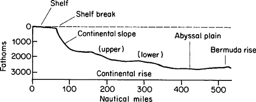
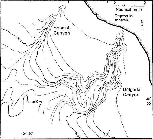
The topography of the deep oceans was known, from soundings, only in broad outline until 50 or 60 years ago. Advances in measurement techniques have made possible much more detailed surveys, particularly with the use of seismic refraction methods, which enable a profile of the ocean floor to be drawn. Methods of coring the floor at great depths have also been developed and, from the core samples obtained, the distribution and composition of the hard rocks that form the floor and its cover of softer sediments have been recorded in many areas. The topographical features of a continental margin, such as that of the North Atlantic, are shown in Fig. 1.1. The continental shelf is a submerged continuation of the land, with a gentle slope of 1 in 1000 or less, and is of varying width. It continues to a depth of about 100 fathoms (183 m), where there is a marked change in slope known as the shelf break, the gradient becoming 1 in 40 or more. The shelf break marks the beginning of the continental slope, which continues until the gradient begins to flatten out and merges into the continental rise, which is often several hundred kilometres wide as in the North Atlantic, with a diminishing gradient. Continental slopes in many places show erosional features known as submarine canyons, which are steep-sided gorge-like valleys incised into the sea floor (Fig. 1.2). Some lie opposite the mouths of large rivers, as at the Hudson Canyon opposite Long Island. Many of the canyons have been excavated by turbidity currents, i.e. submarine movements down the slope, similar to landslides. They carry much suspended sediment and are thus denser than normal sea water. In some instances they continue down to the continental rise.
Fig. 1.1 Profile of a continental margin from the continental shelf to deep ocean floor, based on data from the North Atlantic (after Heezen, Tharp & Ewing. 1959). Horizontal scale in nautical miles (1 nautical mile = 1185 km);vertical scale exaggerated (1 fathom = 1.82 m).
Fig. 1.2 Map of submarine canyons off the West coast of California.
At depths greater than about 2700 fathoms (or 5 km) the deep abyssal plain is reached. This is the ocean floor and from it rise submarine volcanic islands, some of which may be fringed with coral reefs. Volcanoes that no longer break the ocean surface are called drowned peaks or sea mounts. The volcanoes are related to oceanic ridges which form submarine chains of mountains. The mid-Atlantic ridge rises to a height of 2 to 4 km above the ocean floor and is several thousand kilometres wide. Oceanic ridges are discussed further on p. 8.